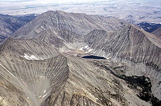
Mount Ouray is a high and prominent mountain summit in the far southern Sawatch Range of the Rocky Mountains of North America. The 13,961-foot (4255.4 m) thirteener is located in San Isabel National Forest, 7.5 miles (12.0 km) west of Poncha Pass, Colorado, United States, on the boundary between Chaffee and Saguache counties. The mountain was named in honor of Ute Chief Ouray.

Mount Cleveland is the highest mountain in Glacier National Park, located in Montana, United States. It is also the highest point in the Lewis Range, which spans part of the northern portion of the park and extends into Canada. It is located approximately 3 mi (4.8 km) southeast of the southern end of Waterton Lake, and approximately 5 mi (8.0 km) south of the US–Canada border. The east side of the future national park was purchased by the federal government from the Blackfoot Confederacy in 1895 during the second term of President Grover Cleveland. According to the United States Board on Geographic Names, the mountain is named for the former president.

The Scapegoat Wilderness consists of 239,936 acres (971 km2) spread across three different National Forests in the U.S. state of Montana. Created by an act of Congress in 1972, the wilderness is located in Lewis and Clark, Helena and Lolo National Forests. The Scapegoat Wilderness is a part of the 1.5 million acre (6,070 km2) Bob Marshall Wilderness Complex as it shares a boundary with the Bob Marshall Wilderness, which in turn is connected to the Great Bear Wilderness further north.
Crazy Peak, elevation 11,214 ft (3,418 m), is the highest peak in the Crazy Mountains, an island range of the Montana Rockies, in the United States. Crazy Peak dominates the surroundings, rising over 7,000 feet (2,100 m) above the Yellowstone River Valley, and is the highest peak in Montana north of the Beartooth Mountains, which are 50 miles (80 km) to the south. Crazy Peak is also the most topographically prominent peak in Montana. A small glacier exists on the northeast slope of the mountain. The mountain is located on private land within the Gallatin National Forest.

Mount Siyeh, with a height of 10,019 feet (3,054 m), is the fifth tallest and one of six peaks over 10,000 feet (3,048 m) in Glacier National Park, Montana, United States. Mount Siyeh was named after a Blackfeet Indian, Sai-yeh, whose name means "Crazy Dog" or "Mad Wolf."

Mount Jackson is located in the Lewis Range, Glacier National Park in the U.S. state of Montana. Mount Jackson is the fourth tallest mountain in Glacier National Park and it is situated on the Continental Divide. Both the mountain and its namesake Jackson Glacier are easily seen from the Going-to-the-Sun Road. Harrison Glacier, the park's largest remaining glacier, is located on the mountain's southern flank. Based on the Köppen climate classification, Mount Jackson has an alpine climate characterized by long, usually very cold winters, and short, cool to mild summers. Temperatures can drop below −10 °F with wind chill factors below −30 °F.

Crested Butte is a prominent mountain summit in the Elk Mountains range of the Rocky Mountains of North America. The 12,168-foot (3,709 m) peak is in Gunnison National Forest, 2.1 miles (3.4 km) northeast by east of the Town of Crested Butte in Gunnison County, Colorado, United States. Ski lifts and runs of the Crested Butte Mountain Resort occupy the north side of the mountain.
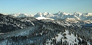
The Whitefish Range is a mountain range stretching north-south from British Columbia, Canada to Montana, United States. It is about 76 miles (122 km) long and 58 miles (93 km) wide. Water flowing from its east side drains down the North Fork Flathead River and its west side drains into the Whitefish River, both part of the Columbia River drainage basin.

The Sweet Grass Hills are a small group of low mountains rising more than 3,000 feet (910 m) above the surrounding plains southwest of Whitlash, Montana, in Liberty and Toole County, Montana. The tallest point in the hills is West Butte at 6,983 feet (2,128 m). Quite prominent in the local area, they are clearly visible from US Highway 2 to the south, I-15, and can sometimes be seen as far North as the Crowsnest Highway (Highway 3) near Medicine Hat in Alberta as well as from the West, near Glacier National Park and Browning, Montana. Visibility may vary depending on local air temperatures or heat domes that may increase or decrease the apparent height of the features. Other named peaks in the small group are Gold Butte (6,512 ft [1,985 m]), East Butte, and Mount Lebanon (5,807 ft [1,770 m]). The Sweet Grass Hills are an example of the island ranges that dot the central third portion of the state of Montana. These island ranges, completely surrounded by the 'sea' of plains and not geographically part of the Rocky Mountains to the west, are "biological hotspots", containing more species than the prairie below.

Red Mountain is located in the Lewis Range, Glacier National Park in the U.S. state of Montana. Red Mountain is 2.75 miles (4.43 km) north of Rising Wolf Mountain.

Long Knife Peak is located in the Clark Range, Glacier National Park in the U.S. state of Montana. Though much of the mountain slopes extend into the Canadian Province of British Columbia, the main summit is in the U.S. Long Knife Peak rises more than a vertical 1 mile (1.6 km) above Upper Kintla Lake. It is also the most northerly peak and land area in the contiguous United States above 9,000 feet (2,743 m). Long Knife Peak is on an east west ridgeline identified as the "Boundary Mountains" on the USGS 7.5 minute topo quad and this extended ridge, with peak 8864, also contains the most northerly named (numbered) peak and land area in the contiguous United States above 8,000 feet (2,438 m).
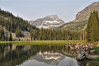
El Capitan is a mountain summit in the Bitterroot Range of Montana. The peak is located in the Selway-Bitterroot Wilderness on land managed by the Bitterroot National Forest. The summit lies 12 miles west of the town of Darby, Montana, and three miles east of the Idaho–Montana border. The highest point of the Central Bitterroot Range is line parent Trapper Peak, 9.3 miles south-southeast.

Highland Peak is a prominent 10,936-foot-elevation (3,333-meter) mountain summit located in the Sierra Nevada mountain range, in Alpine County of northern California, United States. It is situated 3.5 miles east of Ebbetts Pass in the Carson-Iceberg Wilderness, on land managed by Humboldt–Toiyabe National Forest. Although it ranks as the 680th-highest summit in California, it ranks 36th-highest of those with at least 500 meters of topographic prominence. Also, there is no higher peak than Highland Peak to the north within the Sierra Nevada. Highland Peak has a subsidiary South Peak, with one-half mile separation between summits. The Pacific Crest Trail traverses the western foot of this mountain, providing an approach option. Precipitation runoff from this mountain drains into tributaries of the East Fork Carson River.. Topographic relief is significant as the summit rises over 2,900 feet above Noble Canyon in 1.6 mile (2.6 km).

Haystack Butte is a 7,486-foot-elevation (2,282-meter) summit located in the Lewis Range, of Glacier National Park in the U.S. state of Montana. It is situated one mile west of the Continental Divide, in Flathead County, above the Weeping Wall on its south slope. Topographic relief is significant as the west aspect rises 3,900 feet above McDonald Creek in less than 1.5 mile. It can be seen from Logan Pass, and from Going-to-the-Sun Road which traverses the west and south slopes of the peak. The nearest higher neighbor is Mount Gould, 1.07 miles (1.72 km) to the northeast. Climbing access is via the Highline Trail. This geographical feature's descriptive name was on maps as early as 1904, and was officially adopted March 6, 1929, by the United States Board on Geographic Names

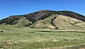
Old Baldy is a 9,156-foot (2,791-metre) double summit mountain located in Teton County of the U.S. state of Montana.

Square Top Mountain is a 13,794-foot (4,204 m) mountain summit in Clear Creek County, Colorado, United States.

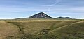
Gold Butte is a 6,512-foot (1,985-metre) mountain summit located in Toole County, Montana, United States.

Mount Lebanon is a 5,807-foot (1,770-metre) mountain summit in Liberty County, Montana, United States.

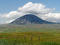
Mount Brown is a 6,958-foot-elevation (2,121-meter) mountain summit located in Liberty County, Montana, United States.
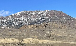
Jim Mountain is a 10,430-foot-elevation (3,179-meter) summit in Park County, Wyoming, United States.