
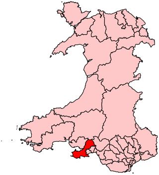
Aberavon is a constituency represented in the House of Commons of the Parliament of the United Kingdom since 2015 by Stephen Kinnock of the Welsh Labour Party. It includes the town of Aberavon, although the largest town in the constituency is Port Talbot.

Until 1974, Glamorgan, or sometimes Glamorganshire, was an administrative county in the south of Wales, and later classed as one of the thirteen historic counties of Wales. Originally an early medieval petty kingdom of varying boundaries known in Welsh as Morgannwg, which was then invaded and taken over by the Normans as the Lordship of Glamorgan. The area that became known as Glamorgan was both a rural, pastoral area, and a conflict point between the Norman lords and the Welsh princes. It was defined by a large concentration of castles.

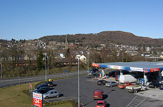
Port Talbot is a town and community in the county borough of Neath Port Talbot, Wales, situated on the east side of Swansea Bay, approximately eight miles from Swansea. The Port Talbot Steelworks covers a large area of land which dominates the south east of the town. It is one of the biggest steelworks in the world, but has been under threat of closure since the 1980s. The population was 31,550 in 2021, comprising about a fifth of the 141,931 population of Neath Port Talbot.

Neath Port Talbot is a county borough in the south-west of Wales. Its principal towns are Neath, Port Talbot, Briton Ferry and Pontardawe. The county borough borders Bridgend County Borough and Rhondda Cynon Taf to the east, Powys and Carmarthenshire to the north; and Swansea to the west.
Pontardawe is a town and a community in the lower Swansea Valley. it had a population of approximately 7,172 in the 2021 Census for Pontardawe Parish, and forms part of the county borough of Neath Port Talbot.
Gower is a constituency created in 1885 and represented in the House of Commons of the UK Parliament by one Member of Parliament (MP). Tonia Antoniazzi of the Labour Party became its MP after winning it from Conservative Byron Davies in the 2017 UK general election. Her party had previously represented the seat from 1909 until 2015.

Mawr is a community of the City and County of Swansea, in south Wales, U.K. Mawr has its own elected community council. Its name simply means "large", and it was given the name because it was the largest piece of land in the former parish of Llangyfelach.

Lliw Valley was a local government district with borough status in West Glamorgan, Wales from 1974 to 1996.

The River Loughor is a river in Wales which marks the border between Carmarthenshire and Swansea. The river is sourced from an underground lake at the Black Mountain emerging at the surface from Llygad Llwchwr which translates from the Welsh as "eye of the Loughor". It flows past Ammanford and Hendy in Carmarthenshire and Pontarddulais in Swansea. The river divides Carmarthenshire from Swansea for much of its course and it separates Hendy from Pontarddulais at the point where the river becomes tidal. The Loughor meets the sea at its estuary near the town of Loughor where it separates the south coast of Carmarthenshire from the north coast of the Gower Peninsula. Among its tributaries is the River Amman and the River Morlais, with the former joining the Loughor near Pantyffynnon. The area of the catchment is some 262 square kilometres (101 sq mi).

Neath Port Talbot County Borough Council is the local authority for the county borough of Neath Port Talbot, one of the 22 principal areas of Wales. The council was controlled by the Labour Party from its creation in 1996 until 2022, when Plaid Cymru and a group of independent councillors agreed to share power.
The City and County of Swansea Council, or simply Swansea Council, is the local authority for the city and county of Swansea, one of the principal areas of Wales. The principal area also includes rural areas to the north of the built-up area of Swansea and the Gower Peninsula to the west. The council consists of 75 councillors representing 32 electoral wards.
Llwchwr is a community and electoral ward in the central western part of the City and County of Swansea, Wales, UK. It lies 9 km west-north-west of Swansea city centre and is bounded by the communities of Gorseinon to the north, Penllergaer to the east, and Gowerton to the south, as well as by the estuary of the River Loughor to the west, on the far side of which lies Bynea in Carmarthenshire, connected to Llwchwr by road and rail bridges.
Rhiwfawr is a village of just under 100 houses in the Swansea Valley, in Neath Port Talbot county borough, Wales.
Aberavon is a constituency of the Senedd. It elects one Member of the Senedd by the first past the post method of election. Also, however, it is one of seven constituencies in the South Wales West electoral region, which elects four additional members, in addition to seven constituency members, to produce a degree of proportional representation for the region as a whole.

Pontardawe Arts Centre is a multi-purpose cultural venue in Pontardawe, Neath Port Talbot, Wales. The building is owned by Neath Port Talbot County Borough Council and is located in Herbert Street.
The history of local government in Wales in a recognisably modern form emerged during the late 19th century. Administrative counties and county boroughs were first established in Wales in 1889. Urban and rural districts were formed in 1894. These were replaced in 1974 by a two-tier authority system across the country comprising eight counties and, within them, thirty-seven districts. This system was itself replaced by the introduction of 22 single-tier authorities in 1996.
Pontardawe is the name of an electoral ward of Neath Port Talbot county borough, Wales. It is a division of the Pontardawe community and falls within the parliamentary constituency of Neath.

The Gower Ornithological Society is a society for professional and amateur birdwatchers covering the geographical areas of south Wales comprising Gower, Swansea, Neath and Port Talbot.
The first election to the Neath Port Talbot County Borough Council was held on 4 May 1995. It was followed by the 1999 election. On the same day there were elections to the other 21 local authorities in Wales and community councils in Wales.
The first election to West Glamorgan County Council was held in April 1973. It was followed by the 1977 election.

