West Monroe, Michigan

Last updated

West Monroe, Michigan
WestMonroeMI.png
West Monroe looking east along M-50
Location within Monroe County
USA Michigan location map.svg
Red pog.svg
West Monroe
Location within the state of Michigan
Usa edcp location map.svg
Red pog.svg
West Monroe
Location within the United States
Coordinates: 41°54′50″N83°25′54″W / 41.91389°N 83.43167°W / 41.91389; -83.43167
CountryUnited States
State Michigan
County Monroe
Township Monroe
Area
[1]
  Total1.27 sq mi (3.29 km2)
  Land1.25 sq mi (3.24 km2)
  Water0.02 sq mi (0.05 km2)
Elevation
600 ft (183 m)
Population
 (2020)
  Total3,227
  Density2,579.54/sq mi (995.89/km2)
Time zone UTC-5 (Eastern (EST))
  Summer (DST) UTC-4 (EDT)
ZIP code(s)
48161 (Monroe)
Area code 734
FIPS code 26-86050 [2]
GNIS feature ID1867326 [3]

West Monroe is an unincorporated community and census-designated place (CDP) in Monroe County in the U.S. state of Michigan. The population was 3,227 at the 2020 census. The CDP is located within Monroe Charter Township.

Contents

Geography

According to the U.S. Census Bureau, the CDP has a total area of 1.27 square miles (3.29 km2), of which 1.25 square miles (3.24 km2) is land and 0.02 square miles (0.05 km2) (1.60%) is water. [1]

Major highways

Demographics

Historical population
CensusPop.Note
1990 3,919
2000 3,893−0.7%
2010 3,503−10.0%
2020 3,227−7.9%
U.S. Decennial Census [4]

As of the census [2] of 2000, there were 3,893 people, 1,505 households, and 1,044 families residing in the CDP. The population density was 3,100.4 inhabitants per square mile (1,197.1/km2). There were 1,599 housing units at an average density of 1,273.5 per square mile (491.7/km2). The racial makeup of the CDP was 96.48% White, 0.98% African American, 0.26% Native American, 0.64% Asian, 0.69% from other races, and 0.95% from two or more races. Hispanic or Latino of any race were 1.77% of the population.

There were 1,505 households, out of which 36.7% had children under the age of 18 living with them, 48.6% were married couples living together, 13.9% had a female householder with no husband present, and 30.6% were non-families. 25.3% of all households were made up of individuals, and 7.9% had someone living alone who was 65 years of age or older. The average household size was 2.59 and the average family size was 3.09.

In the CDP, the population was spread out, with 28.1% under the age of 18, 10.7% from 18 to 24, 32.1% from 25 to 44, 19.7% from 45 to 64, and 9.4% who were 65 years of age or older. The median age was 32 years. For every 100 females, there were 97.1 males. For every 100 females age 18 and over, there were 93.4 males.

The median income for a household in the CDP was $42,986, and the median income for a family was $48,628. Males had a median income of $39,958 versus $25,635 for females. The per capita income for the CDP was $20,067. About 7.9% of families and 12.0% of the population were below the poverty line, including 17.0% of those under age 18 and 7.4% of those age 65 or over.

Related Research Articles

<span class="mw-page-title-main">West Samoset, Florida</span> Census-designated place in Florida, United States

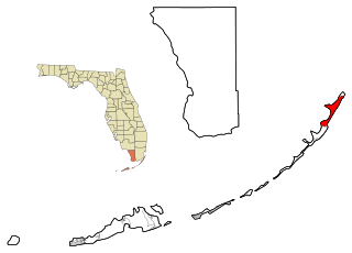
West Samoset is an unincorporated area and census-designated place (CDP) in Manatee County, Florida, United States. The population was 6,482 at the 2020 census, up from 5,583 in 2010. It is part of the Bradenton–Sarasota–Venice Metropolitan Statistical Area.

<span class="mw-page-title-main">North Key Largo, Florida</span> Census-designated place in Florida, United States

North Key Largo is an unincorporated area and census-designated place (CDP) in Monroe County, Florida, United States. The population was 1,431 at the 2020 census, up from 1,244 in 2010. It includes two private clubs, the Ocean Reef Club and the Key Largo Anglers Club, and is reached from the mainland via the Card Sound Bridge.

<span class="mw-page-title-main">Conley, Georgia</span> Census-designated place in Georgia, United States

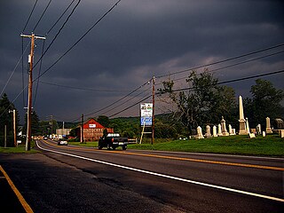
Conley is a census-designated place (CDP) in Clayton County, Georgia, United States. It is at Atlanta’s southeast corner, 7.98 miles from downtown. The population was 6,680 at the 2020 census. It is part of the Atlanta Metropolitan Area.

Midway is an unincorporated community and census-designated place (CDP) in LaSalle Parish, Louisiana, United States. The population was 1,291 at the 2010 census, down from 1,505 at the 2000 census.

Claiborne is an unincorporated community and census-designated place (CDP) in Ouachita Parish, Louisiana, United States. The population was 9,830 at the 2000 census. It is part of the Monroe Metropolitan Statistical Area.

Detroit Beach is an unincorporated community and census-designated place (CDP) in Monroe County in the U.S. state of Michigan. The population was 1,957 at the 2020 census. The CDP is located within Frenchtown Charter Township, and as an unincorporated community, Detroit Beach has no legal autonomy of its own.

<span class="mw-page-title-main">South Monroe, Michigan</span> Census-designated place & unincorporated community in Michigan, United States

South Monroe is an unincorporated community and census-designated place (CDP) in Monroe County in the U.S. state of Michigan. The population was 6,468 at the 2020 census. The CDP is located within Monroe Charter Township.

<span class="mw-page-title-main">Stony Point, Michigan</span> Census-designated place & unincorporated community in Michigan, United States

Stony Point is an unincorporated community and census-designated place (CDP) in Monroe County in the U.S. state of Michigan. The population was 1,784 at the 2020 census. The CDP is located within Frenchtown Charter Township.

<span class="mw-page-title-main">Temperance, Michigan</span> Census-designated place & unincorporated community in Michigan, United States

Temperance is an unincorporated community and census-designated place (CDP) in Monroe County in the U.S. state of Michigan. The population was 9,188 at the 2020 census. The CDP is located within Bedford Township.

<span class="mw-page-title-main">Woodland Beach, Michigan</span> Census-designated place & unincorporated community in Michigan, United States

Woodland Beach is a census-designated place (CDP) and unincorporated community in Monroe County in the U.S. state of Michigan. The population was 1,899 at the 2020 census. The CDP is located within Frenchtown Charter Township.

<span class="mw-page-title-main">Victory Lakes, New Jersey</span> Populated place in Gloucester County, New Jersey, US

Victory Lakes is an unincorporated community and census-designated place (CDP) located within Monroe Township, in Gloucester County, in the U.S. state of New Jersey. As of the 2010 United States Census, the CDP's population was 2,111.

<span class="mw-page-title-main">Concordia, New Jersey</span> Populated place in Middlesex County, New Jersey, US

Concordia is an unincorporated community and census-designated place (CDP) located within Monroe Township, in Middlesex County, in the U.S. state of New Jersey. The CDP is oriented around the age restricted gated community of Concordia. As of the 2010 United States Census, the CDP's population was 3,092.

<span class="mw-page-title-main">Whittingham, New Jersey</span> Populated place in Middlesex County, New Jersey, US

Whittingham, also known as Greenbriar at Whittingham, is an unincorporated community and census-designated place (CDP) located within Monroe Township, in Middlesex County, in the U.S. state of New Jersey. As of the 2010 United States Census, the CDP's population was 2,476. The area is focused around the age-restricted gated community of Whittingham.

<span class="mw-page-title-main">Walton Park, New York</span> CDP in New York, United States

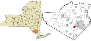
Walton Park is a census-designated place (CDP) in Orange County, New York, United States. As of the 2020 census, the CDP had a total population of 3,907. Walton Park is on the town line separating the towns of Chester and Monroe. Street addresses within Walton Park are usually assigned to Monroe, not Chester.

Arlington Heights is a census-designated place (CDP) in Monroe County, Pennsylvania, United States. The population was 6,331 at the 2020 census. One notable location in Arlington Heights is the Stroud Mall.

<span class="mw-page-title-main">Brodheadsville, Pennsylvania</span> Census-designated place in Pennsylvania, United States

Brodheadsville is a census-designated place (CDP) in Monroe County, Pennsylvania, United States. The population was 1,700 at the 2020 census. The community is served by Pleasant Valley School District.

<span class="mw-page-title-main">Mountainhome, Pennsylvania</span> Census-designated place in Pennsylvania, United States

Mountainhome is a census-designated place (CDP) in Barrett Township, Monroe County, Pennsylvania, United States. The population was 1,182 at the 2010 census.

Brighton is a census-designated place (CDP) in Monroe County, New York, United States. The population was 36,609 at the 2010 census. The CDP takes its name from locations in the county.

Greece is a suburban community and census-designated place in Monroe County, New York, United States. The population was 14,519 at the 2010 census. Google Maps only shows that part of Greece.

<span class="mw-page-title-main">Clearbrook, New Jersey</span> Populated place in Middlesex County, New Jersey, US

Clearbrook is a gated community and census-designated place (CDP) located in Monroe Township, Middlesex County, in the U.S. state of New Jersey. It is in the western part of the township, bordered to the north by Encore at Monroe and to the east by Concordia and The Ponds. It is 3.5 miles (5.6 km) southwest of Jamesburg and 5 miles (8 km) northeast of Hightstown.

References

  1. 1 2 "2020 U.S. Gazetteer Files". United States Census Bureau. Retrieved May 21, 2022.
  2. 1 2 "U.S. Census website". United States Census Bureau . Retrieved January 31, 2008.
  3. U.S. Geological Survey Geographic Names Information System: West Monroe, Michigan
  4. "Census of Population and Housing". Census.gov. Retrieved June 4, 2016.