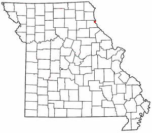
West Quincy is a small commercial area in northeastern Marion County, Missouri, United States, on U.S. Route 24. It has no permanent residents.
West Quincy is a small commercial area in northeastern Marion County, Missouri, United States, on U.S. Route 24. It has no permanent residents.
West Quincy was platted in 1874, and named for its location west of Quincy, Illinois. [1] It is the location of the Lock and Dam No. 21 Historic District, listed on the National Register of Historic Places in 2004. [2]
West Quincy is directly across the Mississippi River from Quincy, Illinois and once housed a Chicago, Burlington & Quincy train station, drive-in theater, and corporation. However, since the Great Flood of 1993, many businesses have left.
The Knapheide corporation headquarters was formerly located in West Quincy, but it has relocated its main location to northern Quincy, Illinois. However, an active Knapheide facility still remains in West Quincy to this day. A tornado hit the drive-in theater and nearly crossed to Quincy but receded once it hit the bluffs.
During the flood of 1993, the levee was sabotaged and water filled the floodplain, and a nearby barge was sucked into the break in the levee. It hit a local gas station and caused an explosion. [3] Oil caught fire and the fire snaked across the water before it extinguished itself. All of the Quincy bridges—the only links across the river from Missouri to Illinois for 200 miles—were closed. One bridge, the Bayview Bridge, was closed for 71 days. [4] This forced residents to drive to St. Louis or Burlington, Iowa, fly or take a ferry to get across the river.
A man from the Illinois side of the river, James Scott, was convicted of causing the flood and was sentenced to life in prison.
Today, West Quincy is home to a number of gas stations that largely serve consumers from Quincy. Missouri's lower state taxes on gasoline and cigarettes are the primary draw, as are the seasonal fireworks tents that spring up in the area during the summer. A number of other small businesses, including a pawn shop, a bank, and a number of car dealerships also operate in West Quincy.

The Mississippi River is the second-longest river and chief river of the second-largest drainage system in North America, second only to the Hudson Bay drainage system. From its traditional source of Lake Itasca in northern Minnesota, it flows generally south for 2,340 miles (3,766 km) to the Mississippi River Delta in the Gulf of Mexico. With its many tributaries, the Mississippi's watershed drains all or parts of 32 U.S. states and two Canadian provinces between the Rocky and Appalachian mountains. The main stem is entirely within the United States; the total drainage basin is 1,151,000 sq mi (2,980,000 km2), of which only about one percent is in Canada. The Mississippi ranks as the thirteenth-largest river by discharge in the world. The river either borders or passes through the states of Minnesota, Wisconsin, Iowa, Illinois, Missouri, Kentucky, Tennessee, Arkansas, Mississippi, and Louisiana.

Quincy, known as Illinois's "Gem City", is a city in and the county seat of Adams County, Illinois, United States, located on the Mississippi River. The 2020 census counted a population of 39,463 in the city itself, down from 40,633 in 2010. As of July 1, 2015, the Quincy Micro Area had an estimated population of 77,220. During the 19th century, Quincy was a thriving transportation center as riverboats and rail service linked the city to many destinations west and along the river. It was Illinois' second-largest city, surpassing Peoria in 1870. The city has several historic districts, including the Downtown Quincy Historic District and the South Side German Historic District, which display the architecture of Quincy's many German immigrants from the late 19th century.

Prairie du Rocher is a village in Randolph County, Illinois, United States. Founded in the French colonial period in the American Midwest, the community is located near bluffs that flank the east side of the Mississippi River along the floodplain often called the "American Bottom". The population was 502 at the 2020 census.

Burlington is a city in, and the county seat of, Des Moines County, Iowa, United States. The population was 23,982 in the 2020 census, a decline from the 26,839 population in 2000. Burlington is the center of a micropolitan area, which includes West Burlington and Middletown, Iowa, and Gulfport, Illinois. Burlington is the home of Snake Alley, an extremely crooked street.
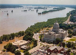
The Great Flood of 1993 was a flood that occurred in the Midwestern United States, along the Mississippi and Missouri rivers and their tributaries, from April to October 1993. The flood was among the most costly and devastating to ever occur in the United States, with $15 billion in damages. The hydrographic basin affected an area approximately 745 miles (1,199 km) in length and 435 miles (700 km) in width, totaling about 320,000 square miles (830,000 km2). Within this zone, the flooded area totaled around 30,000 square miles (78,000 km2) and was the worst such U.S. disaster since the Great Mississippi Flood of 1927, as measured by duration, area inundated, persons displaced, crop and property damage, and number of record river levels. In some categories, the 1993 flood even surpassed the 1927 flood, at the time the largest flood ever recorded on the Mississippi River.

Forgottonia, also spelled Forgotonia, is the name given to a 16-county region in Western Illinois in the late 1960s and early 1970s. This geographic region forms the distinctive western bulge of Illinois that is roughly equivalent to "The Tract", the Illinois portion of the Military Tract of 1812, along and west of the Fourth Principal Meridian. Since this wedge-shaped region lies between the Illinois and Mississippi rivers, it has historically been isolated from the eastern portion of Central Illinois.

The Quincy Rail Bridge is a truss bridge that carries a rail line across the Mississippi River between West Quincy, Missouri, and Quincy, Illinois, USA. It was originally constructed in 1868 for the Chicago, Burlington and Quincy Railroad, a predecessor of BNSF Railway.

The Kansas City Zephyr was a streamliner passenger train service operated by the Chicago, Burlington and Quincy Railroad (CB&Q) between Chicago and Kansas City.

Plano station, also known as the Chicago, Burlington and Quincy Railroad Depot is an Amtrak intercity train station in Plano, Illinois, United States. The station was added to the U.S. National Register of Historic Places on November 12, 1993.

Quincy station is an Amtrak intercity train station in Quincy, Illinois, United States. The station is one of the namesake stations of the Chicago, Burlington and Quincy Railroad, but today serves as the western terminus of Amtrak's Illinois Zephyr and Carl Sandburg trains. It was built in 1985 and was modeled after a former streetcar station of the early 20th Century. Previously, the Illinois Zephyr crossed the Mississippi River and terminated at the former CB&Q station in West Quincy, Missouri after stopping in Quincy; indeed, the Quincy station was built due to West Quincy being frequently cut off by flooding. The decision to build a station on the Illinois side proved to be prescient when the Great Flood of 1993 destroyed the West Quincy station.

The June 2008 Midwestern United States floods were flooding events which affected portions of the Midwestern United States. After months of heavy precipitation, a number of rivers overflowed their banks for several weeks at a time and broke through levees at numerous locations. Flooding continued into July. States affected by the flooding included Illinois, Indiana, Iowa, Michigan, Minnesota, Missouri and Wisconsin. The American Red Cross assisted the victims of flooding and tornadoes across seven states and the National Guard was mobilized to assist in disaster relief and evacuation.

The Iowa flood of 2008 was a hydrological event involving most of the rivers in eastern Iowa which began June 8 and continued until July 1. Flooding continued on the Upper Mississippi River in the southeastern area of the state for many more days. The phrase "Iowa's Katrina" was often heard.
James Robert Scott is an American who was convicted of causing a massive flood of the Mississippi River at West Quincy, Missouri as part of the Great Flood of 1993. Scott is currently serving a sentence of 20 years to life in a Missouri prison. The 2007 book Damned to Eternity and a 2022 Vice News documentary have been critical of Scott's conviction.

The Chicago, Milwaukee, St. Paul and Pacific Freight House, known locally as The Freight House, is a historic building in Downtown Davenport, Iowa, United States. It was listed on the National Register of Historic Places in 1985.

Stolp Island is a small island in the Fox River in Aurora, Illinois. In 1986 the island and its 41 buildings were added to the National Register of Historic Places as the Stolp Island Historic District. It covers 0.03 square miles (0.1 km2) of land area.

Union Station, also known as Union Station and Burlington Freight House, is located along the riverfront in downtown Davenport, Iowa, United States. It is listed on the National Register of Historic Places. The buildings are in a section of downtown with several historic structures. Across Ripley Street to the west is the Chicago, Milwaukee, St. Paul and Pacific Freight House, and to the east across Harrison Street is the Dillon Memorial. On River Drive northwest from the Burlington Freight House is The Linograph Company Building. Across Beiderbecke Drive to the south are the W.D. Petersen Memorial Music Pavilion and the Mississippi River.

The 2011 flooding event on the Missouri River in the United States was triggered by record snowfall in Rocky Mountains of Montana and Wyoming along with near-record spring rainfall in central and eastern Montana. All six major dams along the Missouri River released record amounts of water to prevent overflow which led to flooding threatening several towns and cities along the river from Montana to Missouri; in particular Bismarck, North Dakota; Pierre, South Dakota; Dakota Dunes, South Dakota; South Sioux City, Nebraska, Sioux City, Iowa; Omaha, Nebraska; Council Bluffs, Iowa; Saint Joseph, Missouri; Kansas City, Missouri; Jefferson City, Missouri, and St. Louis, Missouri. Many smaller towns were also at risk, suffering the same fate as the larger cities if not worse. According to the National Weather Service, in the second half of the month of May 2011, almost a year's worth of rain fell over the upper Missouri River basin. Extremely heavy rainfall in conjunction with an estimated 212 percent of normal snowpack in the Rocky Mountains contributed to this flooding event.

The Burlington and Missouri River Railroad Passenger Station is a historic building located in Burlington, Iowa, United States. The station was built by the Burlington and Missouri River Railroad in 1856. It is the oldest train depot in the upper Midwest that is still standing west of the Mississippi River.

The Alton Bridge was a railroad bridge that carried the Chicago, Burlington, and Quincy across the Mississippi River between West Alton, Missouri, and Alton, Illinois. It was located 100 yards (91 m) upriver from, and parallel to, the Old Clark Bridge. The bridge was built between 1892 and 1894 and was removed shortly after the line was abandoned in 1988. With a total length of 2,060 feet (630 m), it consisted of eight through-truss segments—six Pratt trusses, one Pennsylvania truss, and one pivot-swinging truss.

The Midwestern United States experienced major floods in the spring of 2019, primarily along the Missouri River and its tributaries in Nebraska, Missouri, South Dakota, Iowa, and Kansas. The Mississippi River also saw flooding, although starting later and ending earlier. The 2019 January-to-May period was the wettest on record for the U.S., with multiple severe weather outbreaks through May in the Midwest, High Plains, and South exacerbating the flooding and causing additional damage. Throughout late May and early June, rain in Iowa, Illinois, and Missouri caused every site on the Mississippi River to record a top-five crest. At least three people in Iowa and Nebraska died.
Municipalities and communities of Marion County, Missouri, United States | ||
|---|---|---|
| Cities |  | |
| Townships | ||
| CDP | ||
| Other communities | ||
| Ghost towns | ||
| Footnotes | ‡This populated place also has portions in an adjacent county or counties | |