West Rutland, Vermont

Last updated

West Rutland, Vermont
West Rutland Vermont high shool 20040701.jpg
West rutland vt highlight.png
West Rutland, Vermont
Coordinates: 43°35′53″N73°3′3″W / 43.59806°N 73.05083°W / 43.59806; -73.05083
Country United States
State Vermont
County Rutland
NECTA Rutland
Chartered1886
Area
  Total18.0 sq mi (46.6 km2)
  Land18.0 sq mi (46.6 km2)
  Water0.0 sq mi (0.0 km2)
Elevation
489 ft (149 m)
Population
 (2020)
  Total2,214
  Density120/sq mi (48/km2)
Time zone UTC-5 (Eastern (EST))
  Summer (DST) UTC-4 (EDT)
ZIP code
05777
Area code 802
FIPS code 50-82300 [1]
GNIS feature ID1462256 [2]

West Rutland is a town in Rutland County, Vermont, United States. The population was 2,214 at the 2020 census. [3] The town center, located in the south-central portion of the town and where about 87% of the population resides, is defined by the U.S. Census Bureau as a census-designated place (CDP). The town is part of the Rutland micropolitan NECTA.

Contents

Local culture

West Rutland has many small businesses, many of which are found on Marble Street, the town's main street. Other businesses include Boardman Hill Farm (including its associated solar farm) and the Carving Studio & Sculpture Center.

The town has a small public school, West Rutland School, that enrolls students from pre-kindergarten to 12th grade. It is part of the Quarry Valley Unified Union School District. [4]

History

The town of Rutland was originally granted in 1761 as one of the New Hampshire Grants and named after Rutland, Massachusetts, the home of the first grantee, John Murrey. It was one of the most successful of those grants because of excellent farmland and gentle topography.

In 1863, there was rioting in West Rutland after the state instituted a draft. [5]

During a strike in 1868, owners evicted Irish-Catholic workers from company-owned homes, then imported dozens of French-Canadian Catholic "strikebreakers" to replace them. [6]

West Rutland petitioned the Vermont legislature to separate from East Rutland. On November 19, 1886, West Rutland was incorporated as its own town. [7]

The Marble Street Historic District was added to the National Register of Historic Places in 1990. [8]

Marble industry

In the early 19th century, small high-quality marble deposits were discovered in Rutland, and in the 1830s a large deposit of nearly solid marble of high quality was found in what is now West Rutland. By the 1840s small firms had begun operations, but marble quarries only became profitable when the railroad arrived in 1851. At the same time, the famous quarries of Carrara in Tuscany, Italy, became largely unworkable because of their extreme depth, and Rutland quickly became one of the leading producers of marble in the world.

Marble mills c. 1915 Marble Mills, West Rutland, VT.jpg
Marble mills c.1915

This fueled enough growth and investment that in 1886 the marble companies saw to it that when the present Rutland City was incorporated, most of the remainder of the village was split off as West Rutland and Proctor. Although the closing of the marble quarries in the area in the 1980s and 1990s cost the town many jobs, West Rutland has attracted artists and families looking for a semi-rural lifestyle. Because it is a very rural town, much of its economy is dependent on the city of Rutland.

Demographics

Historical population
CensusPop.Note
1880 2,379
1890 3,68054.7%
1900 2,914−20.8%
1910 3,42717.6%
1920 3,391−1.1%
1930 3,4210.9%
1940 2,922−14.6%
1950 2,487−14.9%
1960 2,302−7.4%
1970 2,3813.4%
1980 2,351−1.3%
1990 2,4484.1%
2000 2,5353.6%
2010 2,326−8.2%
2020 2,214−4.8%
U.S. Decennial Census [9]

At the 2010 census, there were 2,326 people, 1,691 households, and 1166 families in the town. The population density was 72.0 people per square mile (54.7/km2). There were 1,079 housing units at an average density of 60.38/sq mi (23.31/km2). The racial makeup of the town was 96.9%% White, 0.5% African American, 0.4% Native American, 1.7% Asian, 0.04% are Pacific Islander, 0.04% from other races, and 0.8% from two or more races. 0.7% of the population were Hispanic or Latino of any race.

Of the 1,021 households 30.1% had children under the age of 18 living with them, 52.8% were married couples living together, 10.1% had a female householder with no husband present, and 32.8% were non-families. 25.9% of households were one person and 12.7% were one person aged 65 or older. The average household size was 2.48 and the average family size was 3.00.

The age distribution was 23.8% under the age of 18, 6.6% from 18 to 24, 29.8% from 25 to 44, 24.7% from 45 to 64, and 15.1% 65 or older. The median age was 39.0 years. For every 100 females, there were 96.1 males. For every 100 females age 18 and over, there were 95.0 males.

The median household income was $67,389 and the median family income was $71,955. Males had a median income of $30,962 versus $21,935 for females. The per capita income for the town was $17,325. 14.7% of the population and 11.2% of families were below the poverty line. Out of the total people living in poverty, 60.8% are under the age of 18 and 9.2% are 65 or older.

Of the 913 households 29.7% had children under the age of 18 living with them, 51.2% were married couples living together, 10.4% had a female householder with no husband present, and 34.2% were non-families. 27.2% of households were one person and 13.3% were one person aged 65 or older. The average household size was 2.48 and the average family size was 3.03.

The age distribution was 24.0% under the age of 18, 7.1% from 18 to 24, 29.7% from 25 to 44, 24.6% from 45 to 64, and 14.6% 65 or older. The median age was 39 years. For every 100 females, there were 97.0 males. For every 100 females age 18 and over, there were 95.1 males.

The median household income was $37,204 and the median family income was $41,795. Males had a median income of $30,861 versus $21,936 for females. The per capita income for the CDP was $17,144. About 6.7% of families and 11.1% of the population were below the poverty line, including 16.3% of those under age 18 and 7.3% of those age 65 or over.

Geography

West Rutland is located at 43°36′38″N72°58′23″W / 43.61056°N 72.97306°W / 43.61056; -72.97306 , at an elevation of 648 feet (198 m), all land. [10] According to the United States Census Bureau, the town has a total area of 17.87 square miles (46.3 km2). Drained by the Clarendon River, West Rutland lies between the Taconic Range and the Green Mountains.

The town is crossed by U.S. Route 4, Vermont Route 3, and Vermont Route 4A.

Town center

The boundaries of the town center as defined by the U.S. Census Bureau are as follows: U.S. Route 4 and some power lines on the west; Dewey Avenue on the southwest; Ira town line on the south; the Clarendon River on the southeast; the Rutland town line on the east; the Proctor town line on the northeast and more power lines on the north and northwest. The area of the CDP is 3.7 square miles (9.6 km2), roughly 21% of the total area of the town.

Climate

The Köppen Climate Classification subtype for this climate is "Dfb" (Warm Summer Continental Climate). [11]

Climate data for West Rutland, Vermont
MonthJanFebMarAprMayJunJulAugSepOctNovDecYear
Mean daily maximum °F (°C)30
(−1)
33
(1)
42
(6)
56
(13)
68
(20)
77
(25)
81
(27)
79
(26)
71
(22)
60
(16)
47
(8)
34
(1)
57
(14)
Daily mean °F (°C)20
(−7)
22
(−6)
32
(0)
45
(7)
56
(13)
65
(18)
69
(21)
68
(20)
60
(16)
49
(9)
38
(3)
26
(−3)
46
(8)
Mean daily minimum °F (°C)11
(−12)
12
(−11)
22
(−6)
33
(1)
44
(7)
53
(12)
58
(14)
56
(13)
48
(9)
38
(3)
29
(−2)
17
(−8)
35
(2)
Average precipitation inches (mm)2.4
(61)
2.0
(51)
2.5
(64)
2.8
(71)
3.5
(89)
3.8
(97)
4.2
(110)
3.8
(97)
3.7
(94)
3.2
(81)
3.1
(79)
2.5
(64)
37.5
(950)
Average precipitation days121011111312111110111212136
Source: Weatherbase [12]

Notable people

Sites of interest

Related Research Articles

<span class="mw-page-title-main">Bennington County, Vermont</span> County in Vermont, United States

Bennington County is a county in the U.S. state of Vermont. As of the 2020 census, the population was 37,347. The shire towns are jointly Bennington and Manchester, and the largest municipality is Bennington. The county was created in 1778.

<span class="mw-page-title-main">Cockeysville, Maryland</span> Census-designated place in Maryland, United States

Cockeysville is a census-designated place (CDP) in Baltimore County, Maryland, United States. The population was 20,776 at the 2010 census.

<span class="mw-page-title-main">Leicester, Vermont</span> Town in Vermont, United States

Leicester is a town in Addison County, Vermont, United States. The population was 990 at the 2020 census. Satans Kingdom is an unincorporated community located in Leicester.

<span class="mw-page-title-main">Dorset, Vermont</span> Town in Vermont, United States

Dorset is a town in Bennington County, Vermont, United States. The population was 2,133 at the 2020 census. Dorset is famous for being the location of Cephas Kent's Inn, where four meetings of the Convention that signed the Dorset Accords led to the independent Vermont Republic and future statehood. Dorset is the site of America's oldest marble quarry and is the birthplace of Bill W., co-founder of Alcoholics Anonymous. East Dorset is the site of the Wilson House and the Griffith Library. The town is named after the English county of Dorset.

<span class="mw-page-title-main">Peru, Vermont</span> Town in Vermont, United States

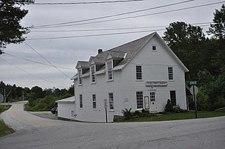
Peru is a town in Bennington County, Vermont, United States. The population was 531 at the 2020 census. Originally known as Bromley, the town name was changed to "Peru" by the land grantees as a way of attracting land buyers to an area that had been described as 36 square miles (93 km2) of "trees, bears and mountain lions".

<span class="mw-page-title-main">Morristown, Vermont</span> Town in Vermont, United States

Morristown is a town in Lamoille County, Vermont, United States. As of the 2020 census, the population was 5,434. Morristown is the largest town by population in Lamoille County, and its central village of Morrisville serves as the county's main commercial center.

<span class="mw-page-title-main">Danby, Vermont</span> Town in Vermont, United States

Danby is a town in Rutland County, Vermont, United States. The population was 1,284 at the 2020 census.

<span class="mw-page-title-main">Ira, Vermont</span> Town in Vermont, United States

Ira is a town in Rutland County, Vermont, United States. The population was 368 at the 2020 census. It was named for Ira Allen, brother of Ethan Allen, who fought with the Green Mountain Boys of the Revolutionary War.

<span class="mw-page-title-main">Mount Tabor, Vermont</span> Town in Vermont, United States

Mount Tabor is a town in Rutland County, Vermont, United States. The population was 210 at the 2020 census.

<span class="mw-page-title-main">Pawlet, Vermont</span> Town in Vermont, United States

Pawlet is a town in Rutland County, Vermont, United States. The population was 1,424 at the 2020 census.

<span class="mw-page-title-main">Proctor, Vermont</span> Town in Vermont, United States

Proctor is a town in Rutland County, Vermont, United States. The population was 1,763 at the 2020 census. Proctor is home to the Vermont Marble Museum and Wilson Castle.

<span class="mw-page-title-main">Sudbury, Vermont</span> Town in Vermont, United States

Sudbury is a town in Rutland County, Vermont, United States. The population was 545 at the 2020 census.

<span class="mw-page-title-main">West Haven, Vermont</span> Town in Vermont, United States

West Haven is a town in Rutland County, Vermont, United States. The population was 239 at the 2020 census.

<span class="mw-page-title-main">Bridgewater, Vermont</span> Town in Vermont, United States

Bridgewater is a town in Windsor County, Vermont, United States. The population was 903 at the 2020 census. Bridgewater contains the hamlets of Bridgewater Village, Bridgewater Corners, West Bridgewater, and Bridgewater Center.

<span class="mw-page-title-main">Rutland (CDP), Massachusetts</span> CDP in Massachusetts, United States

Rutland is a census-designated place (CDP) in the town of Rutland in Worcester County, Massachusetts, United States. The population was 2,111 at the 2010 census.

<span class="mw-page-title-main">Brandon, Vermont</span> Town in Vermont, United States

Brandon is a town in Rutland County, Vermont, United States. As of the 2020 census, the population was 4,129.

<span class="mw-page-title-main">Fair Haven, Vermont</span> Town in Vermont, United States

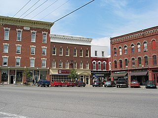
Fair Haven is a town in Rutland County, Vermont, United States. The population was 2,736 at the 2020 census. Within the town is located the census-designated place of Fair Haven. The town is noted for its late 19th century residential and commercial architecture.

<span class="mw-page-title-main">Rutland (town), Vermont</span> Town in Vermont, United States

Rutland is a town in Rutland County, Vermont, United States. As of the 2020 census, the population was 3,924. Rutland Town completely surrounds Rutland City, which is a separate municipality. The villages of the town effectively comprise the inner suburbs of Rutland City.

<span class="mw-page-title-main">Rutland (city), Vermont</span> City in Vermont, United States

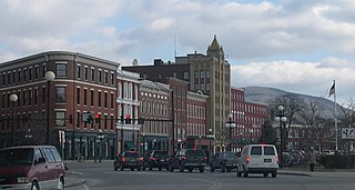
Rutland is the only city in and the seat of Rutland County, Vermont, United States. As of the 2020 census, the city had a total population of 15,807. It is located approximately 65 miles (105 km) north of the Massachusetts state line, 35 miles (56 km) west of New Hampshire state line, and 20 miles (32 km) east of the New York state line. Rutland is the third largest city in the state of Vermont after Burlington and South Burlington. Rutland City is completely surrounded by Rutland Town, which is a separate municipality. The downtown area of the city is listed as a historic district on the National Register of Historic Places.

<span class="mw-page-title-main">Arlington (CDP), Vermont</span> Census-designated place in Vermont, United States

Arlington is a census-designated place (CDP) in the towns of Arlington and Sunderland, Bennington County, Vermont, United States. The population was 1,213 at the 2010 census.

References

  1. "U.S. Census website". United States Census Bureau . Retrieved January 31, 2008.
  2. "US Board on Geographic Names". United States Geological Survey. October 25, 2007. Retrieved January 31, 2008.
  3. "Census - Geography Profile: West Rutland town, Vermont". United States Census Bureau . Retrieved January 7, 2022.
  4. "Home". wrs.grcsu.org.
  5. "Book Reviews" (PDF). vermonthistory.org.
  6. ""Rerum Novarum" and the Catholic Church in Vermont". Vermont Catholic. 1 (12): 21. June 2010.
  7. "West Rutland Vermont | A Truly Special Place | Town Information". westrutlandtown.com.
  8. "National Register of Historical Places - VERMONT (VT), Rutland County". nationalregisterofhistoricplaces.com.
  9. "U.S. Decennial Census". United States Census Bureau. Retrieved May 16, 2015.
  10. "US Gazetteer files: 2010, 2000, and 1990". United States Census Bureau. February 12, 2011. Retrieved April 23, 2011.
  11. "Center Rutland, Vermont Kippen Climate Classification (Weatherbase)". Weatherbase. Retrieved February 3, 2024.
  12. "Weatherbase.com". Weatherbase. 2013. Retrieved on July 2, 2013.
  13. "Rutland County Audubon Society - Birds and Bird Watching in Rutland County, Vermont, USA - Rutland County Audubon Hot Spot:West Rutland Marsh". rutlandcountyaudubon.org.