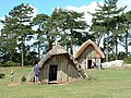
West Stow Anglo-Saxon Village is an archaeological site and an open-air museum located near to West Stow in Suffolk, eastern England. Evidence for intermittent human habitation at the site stretches from the Mesolithic through the Neolithic, Bronze Age, Iron Age and Romano-British period, but it is best known for the small village that existed on the site between the mid-5th century and the early 7th century CE, during the early Anglo-Saxon period. During this time, around 70 sunken-featured buildings were constructed on the site, along with 8 halls and a number of other features. Subsequently, abandoned, the area became farmland in the Late Medieval period.
Antiquarian interest in the site began in 1849, when a nearby Anglo-Saxon cemetery was discovered. Subsequent excavations of Romano-British pottery kilns took place in the late 19th and mid-20th centuries, before the Anglo-Saxon settlement was revealed. The site was excavated between 1956 and 1972 by an archaeological team from the Ministry of Public Buildings and Works (MOPBW), led first by Vera Evison and then by Stanley West. Following the culmination of excavation, it was decided to reconstruct the village on the site, an experimental archaeological project which has been ongoing since 1974. In 1999, the site was opened to the public with a new visitor's centre, museum and cafe.
Location
Panorama of the reconstructed village, on the sloping hill, with the 19th century pines in the background.
West Stow Anglo-Saxon Village is located on the north bank of the River Lark, adjacent to the village of West Stow in the western part of Suffolk.[1] Situated on a small hill 15 feet (4.6m) in height, it would have been noticeably prominent in the surrounding landscape; this hill formed a "core" for a sand dune that developed around from wind-carried sand during the early 14th century and which sharply drops on the leeward side while gradually sloping on the windward side. The steep southern slope is accentuated by a ditch at its base, which marks the edge of the river's flood plain.[2]
The surrounding landscape as it appears today is radically different from the landscape that would have surrounded the area in the Iron Age and Early Medieval periods.[3] The land to the north and east of the West Stow Anglo-Saxon village has been heavily modified during the construction of the Bury sewage farms, with the north-east corner of the site having been partly destroyed by a gravel pit in the 1950s.[2] By the mid-1980s, the rubbish dumps that surrounded the site had been converted into a Country Park, with the landscape being regenerated with sedge, grass, birch and oak.[2] The site of the settlement is also bisected by a row of pine trees that had been planted in the 19th century.[3]
The solid geology of the Lark Valley is chalk, with patches of boulder clay that forms a high plateau capped with sands and gravels in West Stow and Icklingham.[4] The site is seven miles west from the town of Bury St. Edmunds.[1]
Prehistoric settlement
The site at West Stow has shown evidence of human habitation throughout British prehistory. Indeed, the wider Lark Valley contains the greatest known concentration of prehistoric settlements in the region of East Anglia.[4]
Mesolithic
Excavation at West Stow has discovered evidence for hunter-gatherers living in the area during the Mesolithic, or "Middle Stone Age" period. Temporarily camping on the knoll, they left behind them five or six dense concentrations of Sauveterrian-style waste lithic flakes, blades, cores and other stone implements. Similar scatters of Mesolithic worked flints have been found across the valley area.[5]
Neolithic and Bronze Ages
Grooved ware and petit tranchet-style arrowheads dating from the Neolithic Age have been found in a field adjacent to the West Stow site.[6]
Anglo-Saxon settlement
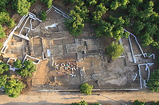
During the early Anglo-Saxon period, West Stow was the site of a small village made up of timber buildings. Archaeological excavation of the site unearthed evidence for a variety of different constructions and areas at West Stow: 69 sunken-featured buildings (SFBs), alongside 7 post-hole buildings interpreted as halls, traces of several lesser structures, a reserve area for clay, 2 large hollows or animal pens, pits, various unassociated post holes and several 7th century boundary ditches.[7] The Anglo-Saxon village showed no signs of the development of property boundaries until the last phase of occupation.[7] There was no evidence that the settlement was defended by fortifications.[7]
Sunken-featured buildings
This section needs expansion. You can help by adding to it. (July 2012)
The majority of structures built at West Stow belonged to a category of what the excavators called "sunken-featured buildings" (SFBs), a term first coined by Professor Philip Rahtz. In previous decades, buildings in this style had been known as "pit houses", "sunken houses" or "grubenhauser" (German: Grubenhäuser), but site director Stanley West noted that Rahtz's terminology had been adopted because it was "less contentious" and provided "a non-functional description."[7][8] Seventy such sunken-featured buildings were recorded at the site.[8]
Halls
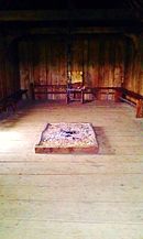
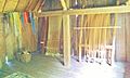
The interior of the reconstructed Hall, constructed in 2005.
The other category of building uncovered at West Stow consisted of seven larger structures held up by wooden posts which left behind postholes; the excavators interpreted these as halls.[3][7] Five of these buildings were located along the central spine of the hill, with the other two being positioned on the north side and south side respectively. All of the buildings were roughly positioned east to west, although the hall on the north slope was instead orientated north-west to south-east.[3]
Four of the halls are simple, rectangular areas which are defined by their single row of post holes.[3] Another, Hall No. 2, was more complex than the others, having an internal division and double post-holes along the length.[3] No. 7 was also different because it was built from a sleeper beam and larger post holes, while Hall No. 5 cannot be clearly defined because it lay in area that had seen multiple features rebuilt on top of it.[3]
Hall 1 was located on the eastern end of the site, and survived as the most clearly defined of the post-built structures. 26ft (7.9m) in length and 13ft 6in (4.11m) in breadth, there are gaps in the south and east side walls, suggesting the existence of two doorways. No hearth was found, although a patch of burnt sand, 2ft (0.61m) in diameter, was found in the centre of the hall. No objects were found within the building, although four were uncovered from the post-holes: a Roman bronze coin from the era of Emperor Valens, a flat iron strip, a flat palette and a fragment of a pottery spindle-whorl.[3]
Hall 2, which was probably the largest of the structures, was located on the crest of the hill, surrounded by SFBs. 32ft (9.8m) in length and 14ft (4.3m) in width, there was a partition down the eastern side of the building, creating a chamber 8ft (2.4m) wide. East of the hall's centre was a patch of burnt sand, marking the position of a hearth. The position of the doorway is not entirely clear, although excavators believed that it was most likely on the south side, close to the partitioning wall. Items discovered in Hall 2 included a Roman bronze coin from the era of the Emperor Victorinus, bronze and iron strips, a bone pin, fragments of both glass and a loomweight, as well as a variety of iron objects, including a knife, nail, plate and key.[9]
The reconstruction of the Hall, constructed in 2005.
The incomplete Hall 3, on the same axis as Halls 1 and 2, was akin in shape and size to the former, but much of its south side had been obliterated by the subsequent construction of other buildings on that site. Fifteen items were found in the interior of the Hall, including three bronze Roman objects; a coin from the era of Emperor Constantine I, a ligula and a dolphin brooch, as well as fragments of glass, a spindlewhorl, and a series of iron objects.[9] Also on this axis was Hall 4, which was also heavily obscured by later building, but it appeared to cover an area at least 22ft (6.7m) long and 16ft (4.9m) wide. Only three finds were discovered from within it; a Roman bronze coin from the era of Emperor Crispus, a Roman glass fragment and a triangular bone comb.[9]
Hall 5 was located on the south-eastern corner of the settlement, on the lowest slope of the hill. Like with several other of the halls, its plan has been obscured by subsequent buildings constructed on the site, although a large number of postholes and three hearths were uncovered; this has led excavators to believe that there had been two halls on that site, one known as 5A and the other as 5B. Finds from the buildings included a number of items made out of bronze, iron and bone.[10]
Hall 6 was at the far western end of the hill, along as the same east-to-west axis as Halls 1, 2, 3 and 4. At least 25ft (7.6m) long and 12ft (3.7m) wide, the structure was apparently relatively weak in design, and within it was discovered a Roman bronze spoon, and two iron objects, one of which was possibly a small chisel.[11] Hall 7 contained a dark layer of material at the occupation layer, with finds including a variety of stones, bones and sherds, along with much burnt daub, unburnt clay mixed with chalk and a broken Anglo-Saxon pot. It has been interpreted as being 37ft 6in in length and 25ft 9in in diameter, making it the largest of the halls at West Stow. It was subject to various possible interpretations, although represented the most sophisticated building at West Stow, involving a more advanced technique than that shown for many of the other constructions. Artefacts found at the site included a number of Roman bronze coins, and a variety of bronze, iron, glass and bone artefacts.[12]
Other features
A number of post-built structures were uncovered at the West Stow Anglo-Saxon settlement which were too small to be interpreted as Halls. These postholes tended to be clustered together, suggesting the possibility that they may have been used to repair small structures. No evidence of fencing was found on any of these structures, which were labelled Buildings 8 through to 14 by the excavators.[8]
At the site, four large areas of grey, disturbed soil were uncovered, three of which were in the eastern side of the settlement. Stratigraphically dated to the Anglo-Saxon period, they all contained a number of small potsherds, with Hollows 1 and 4 also containing a number of bronze and iron objects. The purpose of these Hollows is unknown, although chief excavator Stanley West speculated that they may have represented animal pens which were once surrounded by a form of hurdling or light fencing, traces of which have not survived.[13]
79 pits at the site were also dated to the Anglo-Saxon period, with a further 20 possibles also being identified. This latter group included 12 pits forming a separate group, each of which was rectangular in shape, vertically sided, flat bottomed, and containing a buff sand filling. Their purposes remain unknown.[14]
In the final phase of settlement at the site, it is evident that several ditches were dug, often containing fragments of Ipswich ware and other artefacts. Those ditches dug on the village's western sector appeared to have been used to define certain areas of the settlement, while those on the eastern side serve no apparent functional purpose.[15]
Artefacts
This section needs expansion. You can help by adding to it. (July 2012)
Environmental evidence
This section needs expansion. You can help by adding to it. (July 2012)
Modern history
Excavation: 1849–1976
The first excavations to take place in the vicinity of the West Stow village were undertaken in 1849, when an Anglo-Saxon cemetery was accidentally discovered on the nearby heath, and "skeletons and numerous urns" were found.[16] Finds discovered at the cemetery would be collected by a number of locals until 1852. These included John Gwilt of Icklingham, Reverend S. Banks of Dullingham and the Reverend E.R. Benyon of Culford, who at the time was the proprietor of the heath. None of them ever seem to have publicly suggested that there may have been an Anglo-Saxon settlement nearby.[2] In 1879, and then again in the 1890s, a local amateur archaeologist named Henry Prigg of Icklingham identified and excavated several Romano-British pottery kilns on the heat, although no accurate records from this excavation have survived.[2] In 1940, the archaeologist Basil Brown (1888–1977), best known for having excavated the Anglo-Saxon ship burial at Sutton Hoo in the 1930s, discovered two further Romano-British pottery kilns at the site. He proceeded to excavate them in 1947, and they were sampled for archaeo-magnetic purposes by Dr John Belshé of the Department of Geodosy and Geophysics at the University of Cambridge.[2]
Stone relief depiction of Stanley West holding an archaeological trowel at West Stow.
The man responsible for initiating the archaeological investigation of the Anglo-Saxon village was Stanley West, who had first become interested in Anglo-Saxon England when working as an assistant at the Ipswich Museum. In 1947, he joined the West Stow excavation being run by Brown that unearthed two Romano-British pottery kilns. During this investigation, it became clear to the excavators that there had also been a later Anglo-Saxon settlement on the site, evidenced by the finding of early Anglo-Saxon potsherds in rabbit-burrow scrapes over the area and then the discovery of the section of a hut in the site's north-eastern corner. Proceeding to publish his findings on the kilns in 1952, West went on to excavate Anglo-Saxon areas of Ipswich for the MOPBW alongside studying archaeology in an academic capacity at the University of Cambridge. In April 1958, he attended a conference on early Anglo-Saxon pottery in Norwich that was organised by the Council for British Archaeology. Here, he met Professor Vera Evison of Birkbeck College, London, and posed the question to her as to why archaeologists had so far focused on the excavation of Anglo-Saxon cemeteries rather than settlements; she replied that the latter were far harder to detect than the former. In response, West informed her about the Anglo-Saxon potsherds that had emerged at West Stow, and intrigued, she soon began excavating at the site for the Ministry of Public Building and Works (MOPBW).[2][17]
Meanwhile, inspired by Mary Leakey's discoveries in Olduvai Gorge, West traveled to Eastern Africa to excavate at the Tanganyikan city of Dar Es Salaam, only returning to England five years later, in 1965. Here, Evison and John Hurst, Inspector of the MOPBW asked him to take charge of the West Stow excavation, which he agreed to. Over the next 7 years he opened up an area of approximately ¾ of an acre each season. Funded by the MOPBW, West hoped to excavate as much of the site as possible, but ultimately, the excavation remained restrained to the settlement site, not exploring the surrounding field systems, an idea proposed by Dr. Van Es, Head of the Dutch Archaeological Service.[2][17] The excavation was undertaken by a team of site supervisors and six builders' labourers, aided by roughly 30 volunteers drawn from both universities and the local area.[18]
The top stratigraphic layer on the site, a sediment of blown sand known as Layer 1, was removed by backhoe, exposing the old ground surface (Layer 2) beneath it. Evidence of late medieval ridge-and-furrow ploughing was found in this layer, and dated through the discovery of 13th century pottery. Layer 2 consisted largely of a very dark soil that was removed primarily by backhoe. Below this was revealed the layers in which the Anglo-Saxon village had been constructed.[19] Towards the end of the final season, the excavators at West Stow made use of the pioneering system of retrieving seeds and plant remains by flotation, which had just been developed by archaeologists at the University of Cambridge.[20]
Reconstruction: 1977–present
"Over the first 27 years the West Stow Anglo-Saxon Village project has moved through a series of experimental reconstructions with a controlled development of woodworking and structural detail within the range of technologies available to the Anglo-Saxons. This practical experience has provided fresh insights into the everyday life of an Anglo-Saxon community and has, I believe, put some flesh on the dry bones of archaeology by encouraging the visitor to see the people and appreciate their struggle to survive and indeed, prosper."
The St Edmundsbury District Council planned to turn the area into a rubbish dump servicing the city of Bury St. Edmunds following the culmination of excavation, a decision that was reviewed annually.[17] Eventually they decided against this decision, forming the West Stow Saxon Village Trust, an experimental archaeological group, in order to reconstruct some of the Anglo-Saxon buildings in the hope of learning more about Anglo-Saxon building techniques and architecture. The work was undertaken by a group of undergraduate students from Cambridge University who called themselves the West Stow Environmental Archaeology Group.[2] These experimental reconstructions ensured that they only made use of woodworking techniques and technologies that would have been available in Anglo-Saxon England.[21]
One of the halls excavated at West Stow also provided the basis for a reconstruction erected at the Bishops Wood Environmental Centre near Stourport-on-Severn in Worcestershire; known as "Saxon Hall", it took four years to build, and was used to teach local schoolchildren about life in the Early Medieval. It burned down in 2008 when an ember from a cooking fire set the building alight; John Rhymer, Head of Bishops Wood Centre, told press that he and his team were "devastated". However, the Hall was rebuilt over the following two years at a cost of £34,000. At its official reopening on 21 January 2011, the Anglo-Saxonist Stephen Pollington gave a speech in Old English while a historical reenactor, Paul Mortimer, appeared in character as Raedwald, King of East Anglia. Other attendees included Terry Herbert, who had discovered the Staffordshire Hoard in 2009, members of the Kidderminster Art Society and children on a school trip from Northleigh Manor School in Oxfordshire.[22][23][24]
Anglo-Saxon architecture was a period in the history of architecture in England from the mid-5th century until the Norman Conquest of 1066. Anglo-Saxon secular buildings in Britain were generally simple, constructed mainly using timber with thatch for roofing. No universally accepted example survives above ground. Generally preferring not to settle within the old Roman cities, the Anglo-Saxons built small towns near their centres of agriculture, at fords in rivers or sited to serve as ports. In each town, a main hall was in the centre, provided with a central hearth.
Cadbury Castle is a Bronze and Iron Age hillfort in the civil parish of South Cadbury in the English county of Somerset. It is a scheduled monument and has been associated with King Arthur's legendary court at Camelot.
The Lunt Roman Fort is the archaeological site of a Roman fort, of unknown name, in the Roman province of Britannia. It is open to the public and located in the village of Baginton on the south eastern outskirts of Coventry. The fort has now been fully excavated and partially reconstructed; the wooden gateway rebuild was led by archaeologist Margaret Rylatt, using the same tools and techniques that the military engineers of the Roman Army would have used. In 2001, Anglo Saxon artefacts dating to Sub-Roman Britain were discovered on the site.
Badbury Rings is an Iron Age hill fort and Scheduled Monument in east Dorset, England. It was in the territory of the Durotriges. In the Roman era a temple was located immediately west of the fort, and there was a Romano-British town known as Vindocladia a short distance to the south-west.
Teppe Hasanlu or Hasanlu Tepe is an archeological site of an ancient city located in northwest Iran, a short distance south of Lake Urmia. The nature of its destruction at the end of the 9th century BC essentially froze one layer of the city in time, providing researchers with extremely well preserved buildings, artifacts, and skeletal remains from the victims and enemy combatants of the attack. The site was likely associated with the Mannaeans.
West Stow is a small village and civil parish in West Suffolk, England. The village lies north of Bury St. Edmunds, south of Mildenhall and Thetford and west of the villages of Culford and Ingham in the area known as the Breckland. This area is located near the Lark River Valley and was settled from around AD 420–650. West Stow Hall is to the north of the village.
The Snape Anglo-Saxon Cemetery is a place of burial dated to the 6th century AD located on Snape Common, near to the town of Aldeburgh in Suffolk, Eastern England. Dating to the early part of the Anglo-Saxon Era of English history, it contains a variety of different forms of burial, with inhumation and cremation burials being found in roughly equal proportions. The site is also known for the inclusion of a high status ship burial. A number of these burials were included within burial mounds.
Yeavering is a hamlet in the north-east corner of the civil parish of Kirknewton in the English county of Northumberland. It is located on the River Glen at the northern edge of the Cheviot Hills. It is noteworthy as the site of a large Anglo-Saxon period settlement that archaeologists have interpreted as being one of the seats of royal power held by the kings of Bernicia in the 7th century AD.
Mucking is a hamlet and former Church of England parish and civil parish adjoining the Thames Estuary in the Thurrock unitary authority area, in southern Essex, England. It is located approximately 2 miles (3.2 km) south of the town of Stanford-le-Hope. In 1931 the civil parish had a population of 498.
The Sedgeford Historical and Archaeological Research Project (SHARP) is a long-term, multidisciplinary research project based in north-west Norfolk, United Kingdom. It is involved in the investigation of the local history and archaeology, with a strong emphasis on community involvement, practical training and education. The Project attracts volunteer excavators and students from all over the world.
The Tall Zira'a is an archaeological tell in Jordan. Surveys and geophysical investigations showed the site's great potential for excavations.
Mucking is an archaeological site near the village of Mucking in southern Essex. The site contains remains dating from the Neolithic to the Middle Ages—a period of some 3,000 years—and the Bronze Age and Anglo-Saxon features are particularly notable.
Tel Kabri, or Tell al-Qahweh, is an archaeological tell containing one of the largest Middle Bronze Age Canaanite palaces in Israel, and the largest such palace excavated as of 2014. Kabri is named for the abundance of its perennial springs the presence of which has led to the site's occupation and use as a water source from the Pottery Neolithic (PN) period to the present day. Located in the Western Upper Galilee, the site was at the height of its power in the Middle Bronze, controlling much of the surrounding region. Kabri declined as a local power at the end of the Middle Bronze, but the site continued to be occupied at times, on a much reduced level, up until the 1948 Arab-Israeli War.
Mundigak is an archaeological site in Kandahar province in Afghanistan. During the Bronze Age, it was a center of the Helmand culture. It is situated approximately 55 km (34 mi) northwest of Kandahar near Shāh Maqsūd, on the upper drainage of the Kushk-i Nakhud River.
The archaeology of Anglo-Saxon England is the study of the archaeology of England from the 5th century AD to the 11th century, when it was ruled by Germanic tribes known collectively as the Anglo-Saxons.
Blewburton Hill is the site of an Iron Age hillfort located in Oxfordshire, in the southeast of England. It was a univallate hillfort. The area is mostly farmland with some small areas of wooded copse to the south and the northeast. The hill fort may have been occupied from the 4th century BC to the 1st century BC, and replaced a small settlement surrounded by a stockade, which is estimated to have been built in the 5th or 6th century BC.
The Dinas Powys hillfort is an Iron Age hillfort near Dinas Powys, Glamorgan, Wales. It is just one of several thousand hillforts to have been constructed around Great Britain during the British Iron Age, for reasons that are still debatable. The main fort at Dinas Powys was constructed on the northernmost point of the hill in either the third or 2nd century BCE, with two further constructs, known as the Southern Banks, being built further down on the southern end of the hill in the following 1st century BCE. It appears that occupation at the site ceased during the period of Roman Britain, but was re-inhabited by an Early Mediaeval settlement in the 5th century CE, who constructed further additions to the fort. The site was subsequently excavated by a team of archaeologists led by Leslie Alcock from 1954 through to 1958.
Tell Afis is an archaeological site in the Idlib Governorate of northern Syria, lying about fifty kilometers southeast of Aleppo and 11 kilometers north of the ancient site of Ebla. The site is thought to be that of ancient Hazrek capital of the Kingdom of Hamath and Luhuti. The Stele of Zakkur, dated c, 785 BC, which contains a dedication in Aramaic to the gods Iluwer and Baalshamin, was discovered at the top of the acropolis in 1903 by the French Consul Henri Pognon. It is now in the Louvre Museum.
Tell Yunatsite, also known as Ploskata mogila, is situated in the Pazardzhik Province of southern Bulgaria, some 8 kilometres (5 mi) to the west of the district capital Pazardzhik. The tell stands 12 metres (39 ft) above modern ground level and has a diameter of 110 m (360 ft). It is situated on a low terrace at the right bank of the former Topolnitsa riverbed near to its confluence with the Maritsa River. Medieval, Roman, Iron Age, Early Bronze Age, and Copper Age periods have all been attested at the site. The Copper Age tell is associated with the Karanovo culture.
West, Stanley (1985). West Stow: The Anglo-Saxon Village: Volume I: The Text. East Anglian Archaeology 24. Bury St. Edmunds: Suffolk County Planning Department.
West, Stanley (1985). West Stow: The Anglo-Saxon Village: Volume II: Figures and Plates. Bury St. Edmunds: Suffolk County Planning Department.
West, Stanley (2001). West Stow Revisited. Bury St. Edmunds: St. Edmundsbury Borough Council. ISBN0-9541747-0-4.
This page is based on this Wikipedia article Text is available under the CC BY-SA 4.0 license; additional terms may apply. Images, videos and audio are available under their respective licenses.