
Lincoln is a cathedral city and district in Lincolnshire, England, of which it is the county town. In the 2021 Census, the Lincoln district had a population of 103,813. The 2011 census gave the urban area of Lincoln, including North Hykeham and Waddington, a population of 115,000, a figure which has been updated to 127,540 with the 2021 census.

The Midlands are a part of England that broadly correspond to the Kingdom of Mercia of the Early Middle Ages, bordered by Wales, Northern England, Southern England and the North Sea. The Midlands were important in the Industrial Revolution of the 18th and 19th centuries. They are split into the West Midlands and East Midlands. The region's biggest city, Birmingham – often considered the social, cultural, financial and commercial centre of the Midlands, – is the second-largest city and metropolitan area in the United Kingdom.

North Thoresby is a village and civil parish in the East Lindsey district of Lincolnshire, England. It is situated between Louth and Grimsby, approximately 7.5 miles (12 km) from each. and has a village population of 1,068 (2011) Some 50.5% of the population is older than 60 years.

Scunthorpe is an industrial town in the North Lincolnshire district, in the ceremonial county of Lincolnshire, England. It is Lincolnshire's third most populous settlement, after Lincoln and Grimsby, with a population of 81,286 in 2021. Scunthorpe is the United Kingdom's largest steel processing centre.

Barton-upon-Humber or Barton is a town and civil parish in North Lincolnshire, England. The population at the 2011 census was 11,066. It is situated on the south bank of the Humber Estuary at the southern end of the Humber Bridge. It is 6 miles (10 km) south-west of Kingston upon Hull and 31 miles (50 km) north north-east of the county town of Lincoln. Other nearby towns include Scunthorpe to the south-west and Grimsby to the south-east.

Louth is a market town and civil parish in the East Lindsey district of Lincolnshire, England. Louth serves as an important town for a large rural area of eastern Lincolnshire. Visitor attractions include St James' Church, Hubbard's Hills, the market, many independent retailers and Lincolnshire's last remaining cattle market.

Market Deeping is a market town and civil parish in the South Kesteven district of Lincolnshire, England, on the north bank of the River Welland and the A15 road. The population of the town at the 2011 census was 6,008.

Metheringham is a village and civil parish in the North Kesteven district of Lincolnshire, England. The population of the civil parish at the 2011 census was 3,605. It is about 9 miles (14 km) south of Lincoln and 10 miles (16 km) north of Sleaford. The centre of the village is a conservation area.

Gedney Hill is a village and civil parish in South Holland district of Lincolnshire, England. The population of the civil parish at the 2011 census was 737. It is situated close to the border of Cambridgeshire, and approximately 9 miles (14 km) south-east of Spalding, 8 miles (13 km) west of Wisbech and 9 miles (14 km) south of Holbeach.
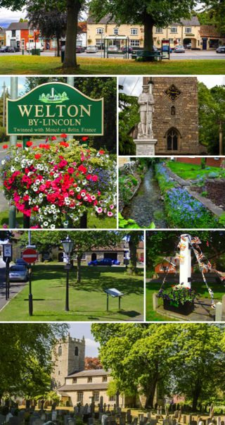
Welton is a large village and civil parish in the West Lindsey district of Lincolnshire, England. The population of the civil parish was recorded as 4,327 in the 2011 census. It is geographically situated 10 km (6 mi) north from Lincoln city centre. The name Welton by Lincoln is also used to distinguish from other similarly named villages in Lincolnshire: Welton le Wold and Welton le Marsh.

Surfleet is a small village and civil parish in the South Holland district of Lincolnshire, England. It is situated on the B1356 road, 3 miles (4.8 km) north of Spalding, in the Lincolnshire fens. The River Glen runs through the village.

700 Naval Air Squadron is an experimental test squadron in the Royal Navy’s Fleet Air Arm.

Scampton is a village and civil parish in the West Lindsey district of Lincolnshire, England. The population of the civil parish including Brampton and Broadholme at the 2011 census was 1,358. It is situated 8 km (5 mi) north of Lincoln, 16 km (10 mi) south-east of Gainsborough, and immediately west of the A15.
Heckington is a village and civil parish in the North Kesteven district of Lincolnshire, England. It is situated between Sleaford and Swineshead Bridge, and south of the A17 road. Heckington, with 1,491 households, is one of the largest villages in Lincolnshire. The population of the civil parish including Boughton was 3,353 at the 2011 census.
Pinchbeck is a village and civil parish in the South Holland district of Lincolnshire, England. The civil parish population was 5,153 at the 2001 census, 5,455 at the 2011 census and 6,011 at the 2021 census. It is situated 2 miles (3.2 km) north from the centre of Spalding.

Dry Doddington is a small village in the north-west of the South Kesteven district of Lincolnshire, England within the civil parish of Westborough and Dry Doddington. It is situated approximately 5 miles (8 km) south-east from Newark, approximately 8 miles (13 km) north-west from Grantham, and just over 1 mile (2 km) to the east from the A1 road.

Weston is a village and civil parish in the South Holland district of Lincolnshire, England. It is situated approximately 2 miles (3 km) north-east from the town of Spalding. The Civil Parish also includes Weston Hills. The population of the civil parish including Austendike was at the 2011 census 2,054.

This is the Military intervention against ISIL aerial order of battle, which lists the American forces and allies aerial assets that have taken part in the Military intervention against ISIL between June 2014 and the present day.

