Wetlands of Louisiana

Last updated

Atchafalaya Basin Atchafalaya Basin.jpg
Atchafalaya Basin

The wetlands of Louisiana are water-saturated coastal and swamp regions of southern Louisiana, often called 'Bayou'.

Contents

The Louisiana coastal zone stretches from the border of Texas to the Mississippi line [1] and comprises two wetland-dominated ecosystems, the Deltaic Plain of the Mississippi River (unit 1, 2, and 3) and the closely linked Chenier Plain (unit 4). [2] The Deltaic Plain contains numerous barrier islands and headlands, such as the Chandeleur Islands, Barataria Basin Barrier Islands, and Terrebonne Basin Barrier Islands. [3] The Coastal Wetlands Planning, Protection and Restoration Act (CWPPRA) program, through the NOAA Habitat Conservation National Marine Fisheries Service funded $102 million in construction for deteriorated wetlands and barrier island habitats. [4]

Geography

The Environmental Protection Agency defines wetlands as "those areas that are inundated or saturated by surface or groundwater at a frequency and duration water to support, and that under normal circumstances do support, a prevalence of vegetation typically adapted for life in saturated soil conditions (e.g. swamps, bogs, fens, marshes, and estuaries)." [5] Different wetland types arise due to a few key factors, primarily: water levels, fertility, natural disturbance and salinity. [6] Around Lake Pontchartrain, for example, these few factors produce wetlands including bottomland hardwoods, cypress swamp, freshwater marsh and brackish marsh. [7] High levels of flooding reduce the abundance of trees, leaving four principal marsh types: saline, brackish, intermediate and fresh. [8]

Although these areas make up a very small percentage of the total land found in the United States, southern Louisiana contains 40 to 45 percent of the wetlands found in the lower states. This is because Louisiana is the drainage gateway to the Gulf of Mexico for the Lower Mississippi Regional Watershed. The Lower Mississippi Regional Watershed drains more than 24 million acres (97,000 km2) in seven states from southern Illinois to the Gulf of Mexico. Hence the wetlands of this area are important at the national scale. [9]

On the east side of Louisiana, coastal wetlands intergrade with long leaf pine savannas, which support many rare and unusual species such as pitcher plants and gopher tortoises. [10] [ self-published source ] On the western side, they intergrade with wet prairies, an ecosystem type that was once vast, and now has been all but eliminated. [10] The larger vertebrate fauna such as wolves and bison was exterminated. The eastern coastline of Louisiana is much more susceptible to erosion than the western coastline because much of the eastern coastline was created by silt deposits from the Mississippi River. This natural process of sediment deposition has been blocked by an extensive levee system that directs flood water past wetlands. [11] The western coastline is marshy, but the marshes only extend inland by 30 miles (48 km) at the most, then the elevation begins to increase and the marshes fade into solid grounded prairies. Therefore, rising sea levels due to global warming and coastal erosion, may not affect the western coastline as profoundly as it will the eastern half, which may be replaced in open water over substantial areas.

Loss of the wetlands

Diorama picturing wetland loss in coastal Louisiana as attributed to human activities The wetland lose of southern louisiana due to human activities.jpg
Diorama picturing wetland loss in coastal Louisiana as attributed to human activities

The wide range of benefits provided by the wetlands of this region were not recognized by a majority of policy makers in the early 20th century. Wetlands provide vital ecological services including flood control, fisheries production, carbon storage, water filtration and enhanced disagreement over the relative importance of these factors, [12] although it is probably safe to say that the two major factors now acting are subsidence, mostly from lack of sediment, and salt water intrusion from canals dredged to service oil and gas wells and facilitate oil and gas exploration. Further wetland loss is attributed to the construction of the now-closed Mississippi River Gulf Outlet, which introduced salt water into freshwater and intermediate marshes and facilitated significant erosion. [13] A brief explanation of various causes follows.

Subsidence of the coast is certainly occurring. Some people blame the direct effects of oil and gas extraction. The logic is that as billions of barrels of oil and saltwater and as trillions of cubic feet of gas were removed from the reservoirs in which they had accumulated over millions of years, these reservoirs lost their ability to support the weight of the rocks above. [14] As these structures slowly collapsed, the soil above gradually subsided. The wetlands on the surface began to sink into the gulf waters. Others argue that subsidence is a natural process in deltas, as sediments compress, and that the real problem is the lack of flood waters that would normally deposit new layers of sediment. [15] [16] The role of hurricanes is also a matter of disagreement; some studies show that hurricanes actually build elevation in marshes. [17] Another factor is rising sea levels estimated to be about 2mm per year [18] associated with global warming. [19] [20]

Sediment compaction is also a significant source of wetland loss. Compaction rates have been conservatively estimated at 5mm to 10mm or more per year for the organic-rich Holocene sediment (peat) that predominates the Mississippi River Delta environment. Given the ubiquity of this compaction-prone sediment in southern Louisiana, coastal restoration project managers (see: Louisiana Coastal Protection and Restoration Authority) must consider the underlying geology of their regions prior to development as to not exacerbate rates of compaction. [21]

An extensive levee system aided by locks and dams has been developed in the waterways of the lower Mississippi River. [22] The levees (designed to prevent flooding along the waterways) prevent needed sediment from being distributed into the marshes downriver. With no new accretion and with steady subsidence, the wetlands slowly are replaced by encroaching saltwater from the Gulf. As a result of this apparent engineering dilemma, large areas of marsh are being lost to the ocean. Since 1930 water has consumed more than 1,900 square miles (4,900 km2) of the state's land. This loss equates to the disappearance of 25 square miles (65 km2) of wetlands each year, or a football field sized area every 30 minutes. This loss can be reversed (at least in some areas) but, only with large scale restoration, including the removal of levees to allow the Mississippi River to carry sediment into these areas. [6] [23]

Another factor that damaged wetlands was large scale logging, particularly the extensive logging of cypress forests in the early 1900s. [24] One early logger described it this way: "We just use the old method of going in and cutting down the swamp and tearing it up and bringing the cypress out. When a man's in here with all the heavy equipment, he might as well cut everything he can make a board foot out of; we're not ever coming back in here again". [25] [ self-published source ] This logging often required construction of canals, which, once the logging was finished, allowed salt water to enter the wetlands and prevent regeneration of the cypress. [7]

As if these problems were not enough, the introduction of nutria from South America in the 1930s provided an entirely new species of grazing mammal. Although only a few escaped, there are now millions. [26] [27] [ self-published source ] Natural grazing by muskrat was now accelerated by grazing from nutria. By removing plants, nutria both cause loss of vegetation, and, perhaps more seriously, a loss of dead organic matter which would otherwise accumulate as peat and raise the level of the marsh [28] One of the most important natural controls on nutria is large alligators, which may provide a useful tool for biological control of nutria, and therefore for reduced impacts of grazing. [29]

Southern Louisiana's disappearing wetlands have a broad impact ranging from cultural to economic. Commercial fishing in Louisiana accounts for more than 300 million dollars of the state's economy. More than 70% of that amount stems from species such as shrimp, oysters and blue crabs that count on the coastal wetlands as a nursery for their young. Annually Louisiana sells more than 330,000 hunting licenses and 900,000 fishing licenses to men and women who depend on the wetlands as a habitat for their game. Additional recreational activities such as boating, swimming, camping, hiking, birding, photography and painting are abundant in wetland areas. Wetlands host a variety of trees such as the bald cypress, tupelo gum and cottonwood. Other plants such as the dwarf palmetto and wax myrtle and submerged aquatic plants such as Vallisneria and Ruppia are native to Louisiana wetlands. Wetland plants act as natural filters, helping to remove heavy metals, sewage, and pesticides from polluted water before reaching the Gulf of Mexico. Animal species native to these areas include osprey, anhinga, ibis, herons, egrets, manatees, alligators, and beavers. Although there are several naturally occurring forces that adversely affect the wetland regions of Louisiana, many believe it is human intervention that has caused the majority of the decline. [30]

Prior to the building of levees on the Mississippi River, the wetlands were kept in balance by occasional floods, which fill the area with sediment, and subsidence, the sinking of land. After the levees were built, however, flood sediment flowed directly into the Gulf of Mexico. This subsidence along with the recent sea level rise tipped the balance toward subsidence rather than marsh growth. This, along with the canals built in the area, caused decline of the wetlands and also caused less weakening of and less protection from recent hurricanes such as Hurricane Katrina. [30] The Lake Pontchartrain Basin Foundation has developed a comprehensive management plan [31] for the eastern regions of the Louisiana coast, placing emphasis upon restoration of river habitats, cypress swamps and fringing marsh. This could be a model applied to other coastal regions.

Oil company canals

The dredging of access canals by oil companies has long been considered to be a cause of coastal erosion. These concerns were raised in 1925 and continued with a 2013 lawsuit against many oil companies. [32]

Policy and protection

The National Oceanic and Atmospheric Administration (NOAA) enacted the Coastal Zone Management Act of 1972 (CZMA) amended by 16 U.S.C. 1451 et seq. that includes Louisiana, to develop plans providing assessment priorities for land conservation needs. The agency provides guidance in selecting conservation projects in the state. In 2002 the Secretary of Commerce was directed by Congress to establish the Coastal and Estuarine Land Conservation Program (CELCP), "for the purpose of protecting important coastal and estuarine areas that have significant conservation, recreation, ecological, historical, or aesthetic values, or that are threatened by conversion from their natural or recreational state to other uses", through the Department of Commerce, Justice, and State Appropriations Act of 2002 by Public Law 107-77. This was re-authorized in 2009 by the Omnibus Public Land Management Act (P.L. 111-11).

In 2002, Congress directed the Secretary of Commerce to establish a Coastal and Estuarine Land Conservation Program (CELCP) "for the purpose of protecting important coastal and estuarine areas that have significant conservation, recreation, ecological, historical, or aesthetic values, or that are threatened by conversion from their natural or recreational state to other uses" (The Department of Commerce, Justice, and State Appropriations Act of 2002, Public Law 107-77). CELCP was re-authorized in 2009 as part of the Omnibus Public Land Management Act (P.L. 111-11).

The Louisiana Department of Natural Resources, Office of Coastal Management, Inter-agency Affairs and Field Service Division (LDNR/OCM/IAFSD) became the lead agency for implementing a state coastal management program, or CELCP program, based on federal guidelines. Louisiana chose the conditionally approved Coastal Nonpoint Pollution Control Program (CNPCP) boundaries. On January 23, 2008, the Governor of Louisiana signed Executive Order No. BJ 2008-7, creating the Coastal Protection and Restoration Authority (CPRA), that implemented the Integrated Ecosystem Restoration and Hurricane Protection plan, becoming known as the "Master Plan."

See also

Related Research Articles

<span class="mw-page-title-main">Swamp</span> A forested wetland

A swamp is a forested wetland. Swamps are considered to be transition zones because both land and water play a role in creating this environment. Swamps vary in size and are located all around the world. The water of a swamp may be fresh water, brackish water, or seawater. Freshwater swamps form along large rivers or lakes where they are critically dependent upon rainwater and seasonal flooding to maintain natural water level fluctuations. Saltwater swamps are found along tropical and subtropical coastlines. Some swamps have hammocks, or dry-land protrusions, covered by aquatic vegetation, or vegetation that tolerates periodic inundation or soil saturation. The two main types of swamp are "true" or swamp forests and "transitional" or shrub swamps. In the boreal regions of Canada, the word swamp is colloquially used for what is more formally termed a bog, fen, or muskeg. Some of the world's largest swamps are found along major rivers such as the Amazon, the Mississippi, and the Congo.

<span class="mw-page-title-main">Grand Isle, Louisiana</span> Town in Louisiana, United States

Grand Isle is a town in Jefferson Parish in the U.S. state of Louisiana, located on a barrier island of the same name in the Gulf of Mexico. The island is at the mouth of Barataria Bay where it meets the gulf. The town of Grand Isle is statistically part of the New Orleans−Metairie−Kenner metropolitan statistical area, though it is not connected to New Orleans' continuous urbanized area.

<span class="mw-page-title-main">Lake Pontchartrain</span> Estuary located in southeastern Louisiana, United States

Lake Pontchartrain is an estuary located in southeastern Louisiana in the United States. It covers an area of 630 square miles (1,600 km2) with an average depth of 12 to 14 feet. Some shipping channels are kept deeper through dredging. It is roughly oval in shape, about 40 miles (64 km) from west to east and 24 miles (39 km) from south to north.

<span class="mw-page-title-main">Pearl River (Mississippi–Louisiana)</span> River in Mississippi and Louisiana, United States

The Pearl River is a river in the U.S. states of Mississippi and Louisiana. It forms in Neshoba County, Mississippi from the confluence of Nanih Waiya and Tallahaga creeks, and has a meander length of 444 miles (715 km). The lower part of the river forms part of the boundary between Mississippi and Louisiana.

<span class="mw-page-title-main">Aquatic ecosystem</span> Ecosystem in a body of water

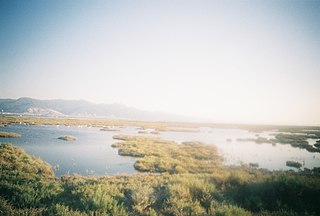
An aquatic ecosystem is an ecosystem found in and around a body of water, in contrast to land-based terrestrial ecosystems. Aquatic ecosystems contain communities of organisms—aquatic life—that are dependent on each other and on their environment. The two main types of aquatic ecosystems are marine ecosystems and freshwater ecosystems. Freshwater ecosystems may be lentic ; lotic ; and wetlands.

<span class="mw-page-title-main">Lake Borgne</span> Lagoon of the Gulf of Mexico in southeastern Louisiana, United States

Lake Borgne is a lagoon of the Gulf of Mexico in southeastern Louisiana. Although early maps show it as a lake surrounded by land, coastal erosion has made it an arm of the Gulf of Mexico. Its name comes from the French word borgne, which means "one-eyed."

<span class="mw-page-title-main">Mississippi River Delta</span> Delta of the Mississippi River

The Mississippi River Delta is the confluence of the Mississippi River with the Gulf of Mexico in Louisiana, southeastern United States. The river delta is a three-million-acre area of land that stretches from Vermilion Bay on the west, to the Chandeleur Islands in the east, on Louisiana's southeastern coast. It is part of the Gulf of Mexico and the Louisiana coastal plain, one of the largest areas of coastal wetlands in the United States. The Mississippi River Delta is the 7th largest river delta on Earth (USGS) and is an important coastal region for the United States, containing more than 2.7 million acres of coastal wetlands and 37% of the estuarine marsh in the conterminous U.S. The coastal area is the nation's largest drainage basin and drains about 41% of the contiguous United States into the Gulf of Mexico at an average rate of 470,000 cubic feet per second.

<span class="mw-page-title-main">Hurricane preparedness in New Orleans</span>

Hurricane preparedness in New Orleans has been an issue since the city's early settlement because of its location.

Drainage in New Orleans, Louisiana, has been a major concern since the founding of the city in the early 18th century, remaining an important factor in the history of New Orleans today. The central portion of metropolitan New Orleans is fairly unusual in that it is almost completely surrounded by water: Lake Pontchartrain to the north, Lake Borgne to the east, wetlands to the east and west, and the Mississippi River to the south. Half of the land area between these bodies of water is at or below sea level, and no longer has a natural outlet for flowing surface water. As such, virtually all rainfall occurring within this area must be removed through either evapotranspiration or pumping. Thus, flood threats to metropolitan New Orleans include the Mississippi River, Lake Pontchartrain, canals throughout the city, and natural rainfall. Artificial levees have been built to keep out rising river and lake waters but have had the negative effect of keeping rainfall in, and have failed on numerous occasions.

<span class="mw-page-title-main">Atchafalaya Basin</span> Largest wetland and swamp in the United States

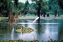
The Atchafalaya Basin, or Atchafalaya Swamp, is the largest wetland and swamp in the United States. Located in south central Louisiana, it is a combination of wetlands and river delta area where the Atchafalaya River and the Gulf of Mexico converge. The river stretches from near Simmesport in the north through parts of eight parishes to the Morgan City southern area.

The Louisiana Coastal Protection and Restoration Authority (CPRA) is a governmental authority created by the Louisiana State Legislature in the aftermath of Hurricanes Katrina and Rita. The CPRA reports to the Office of the Governor of Louisiana. The organization takes advantage of both federal and state funding of around $1 billion annually. Since its founding, the organization has completed over 140 projects, benefitting 55,807 acres (87.198 sq mi) of land, placing 193 million cubic yards of sediment, improving 369 miles (594 km) of levees, and restoring 71.6 miles (115.2 km) of barrier islands. CPRA predicts that, without action over the next 50 years, between 1,100 and 3,000 square miles (2,800 and 7,800 km2) of coastal land may be lost, depending on a low (1.6 feet (0.49 m)) or high (2.5 feet (0.76 m)) forecast of local sea level rise.

<span class="mw-page-title-main">Coastal Wetlands Planning, Protection and Restoration Act</span>

The Coastal Wetlands Planning, Protection and Restoration Act (CWPPRA) was passed by Congress in 1990 to fund wetland enhancement. In cooperation with multiple government agencies, CWPPRA is moving forward to restore the lost wetlands of the Gulf Coast, as well as protecting the wetlands from future deterioration. The scope of the mission is not simply for the restoration of Louisiana's Wetlands, but also the research and implementation of preventative measures for wetlands preservation.

Pass a Loutre Wildlife Management Area (WMA) is a 115,000-acre (47,000 ha) protected wetland in Plaquemines Parish, Louisiana, United States. The WMA is located due south and bordering the 48,000 acre Delta National Wildlife Refuge, accessible only by air or boat, contains the Pass A L'Outre Lighthouse, and Port Eads is within the boundary.

<span class="mw-page-title-main">Effects of Hurricane Isaac in Louisiana</span> Effects of Hurricane Isaac in 2012

The effects of Hurricane Isaac in Louisiana were more severe than anywhere in the storm's path, and included $611.8615 million in damages and five total deaths. Forming from a tropical wave in the central Atlantic, Isaac traversed across many of the Lesser and Greater Antilles, before reaching peak intensity with winds of 80 mph (130 km/h) on August 28, 2012 while in the Gulf of Mexico. Nearing the coast of Louisiana, the Category 1 hurricane slowly moved towards the west, making two landfalls in the state with little change of intensity prior to moving inland for a final time. The hurricane weakened and later dissipated on September 1 while over Missouri. Before landfall, Governor Bobby Jindal declared a state of emergency to the state, as well as ordering the mandatory evacuation of 60,000 residents in low-lying areas of Louisiana along the Tangipahoa River in Tangipahoa Parish.

<span class="mw-page-title-main">Fauna of Louisiana</span> State ecology

The fauna of Louisiana is characterized by the region's low swamplands, bayous, creeks, woodlands, coastal marshlands and beaches, and barrier islands covering an estimated 20,000 square miles, corresponding to 40 percent of Louisiana's total land area. Southern Louisiana contains up to fifty percent of the wetlands found in the Continental United States, and are made up of countless bayous and creeks.

The Mississippi Alluvial Plain is a Level III ecoregion designated by the Environmental Protection Agency (EPA) in seven U.S. states, though predominantly in Arkansas, Louisiana, and Mississippi. It parallels the Mississippi River from the Midwestern United States to the Gulf of Mexico.

<span class="mw-page-title-main">Coastal erosion in Louisiana</span> Overview of costal erosion in Louisiana

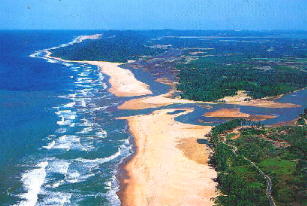
Coastal erosion in Louisiana is the process of steady depletion of wetlands along the state's coastline in marshes, swamps, and barrier islands, particularly affecting the alluvial basin surrounding the mouth of the Mississippi River. In the last century, coastal Louisiana has lost an estimated 4,833 square kilometers (1,866 sq mi) of land, approximately the size of Delaware's land area. Coast wide rates of wetland change have varied from −83.5 square kilometers (−32.2 sq mi) to −28.01 square kilometers (−10.81 sq mi) annually, with peak loss rates occurring during the 1970's. One consequence of coastal erosion is an increased vulnerability to hurricane storm surges, which affects the New Orleans metropolitan area and other communities in the region. The state has outlined a comprehensive master plan for coastal restoration and has begun to implement various restoration projects such as fresh water diversions, but certain zones will have to be prioritized and targeted for restoration efforts, as it is unlikely that all depleted wetlands can be rehabilitated.

<span class="mw-page-title-main">Land loss</span>

Land loss is the term typically used to refer to the conversion of coastal land to open water by natural processes and human activities. The term land loss includes coastal erosion. It is a much broader term than coastal erosion because land loss also includes land converted to open water around the edges of estuaries and interior bays and lakes and by subsidence of coastal plain wetlands. The most important causes of land loss in coastal plains are erosion, inadequate sediment supply to beaches and wetlands, subsidence, and global sea level rise. The mixture of processes responsible for most of the land loss will vary according to the specific part of a coastal plain being examined. The definition of land loss does not include the loss of coastal lands to agricultural use, urbanization, or other development.

<span class="mw-page-title-main">Sedimentation enhancing strategy</span> Environmental management projects aiming to restore land-building processes in deltas

Sedimentation enhancing strategies are environmental management projects aiming to restore and facilitate land-building processes in deltas. Sediment availability and deposition are important because deltas naturally subside and therefore need sediment accumulation to maintain their elevation, particularly considering increasing rates of sea-level rise. Sedimentation enhancing strategies aim to increase sedimentation on the delta plain primarily by restoring the exchange of water and sediments between rivers and low-lying delta plains. Sedimentation enhancing strategies can be applied to encourage land elevation gain to offset sea-level rise. Interest in sedimentation enhancing strategies has recently increased due to their ability to raise land elevation, which is important for the long-term sustainability of deltas.

Terrebonne Basin is an abandoned delta complex, in Terrebonne Parish, Louisiana. The area is identified by thick sections of unconsolidated sediments that are undergoing dewatering and compaction which contributes to high subsidence. There is a network of old distributary ridges, associated with past distributaries of the Mississippi River, extending south from Houma, Louisiana into the Gulf of Mexico.

References

  1. "Department of Natural Resources | State of Louisiana". Dnr.louisiana.gov. Retrieved 2021-11-26.
  2. Penland, Shea; Ramsey, Karen E. (1990). "Relative Sea-Level Rise in Louisiana and the Gulf of Mexico: 1908-1988". Journal of Coastal Research. 6 (2): 323–342. ISSN   0749-0208. JSTOR   4297682.
  3. "Archived copy" (PDF). Archived from the original (PDF) on 2017-01-31. Retrieved 2017-02-28.{{cite web}}: CS1 maint: archived copy as title (link)
  4. "NOAA Habitat Conservation | Restoring Barrier Islands in Louisiana". Archived from the original on 2017-03-07. Retrieved 2017-02-28.
  5. "EPA: Term :". Iaspub.epa.gov. Retrieved 13 February 2022.
  6. 1 2 Keddy, P.A. 2010. Wetland Ecology: Principles and Conservation (2nd edition). Cambridge University Press, Cambridge, UK. 497 p.
  7. 1 2 Keddy, P.A.; Campbell, D.; McFalls, T.; Shaffer, G.; Moreau, R.; Dranguet, C.; Heleniak, R. (2007). "The wetlands of lakes Pontchartrain and Maurepas: past, present and future". Environmental Reviews. 15: 1–35. doi:10.1139/a06-008.
  8. Chabreck, R. H. 1972. Vegetation, Water and Soil Characteristics of the Louisiana Coastal Region. Louisiana State University, Agricultural Experiment Station Bulletin No. 664
  9. Gosselink, J. G., J. M. Coleman, and R. E. Stewart, Jr. 1998. Coastal Louisiana. pp. 385–436. In M. J. Mac, P. A. Opler, C. E. Puckett Haecker, and P. D. Doran 1998. Status and Trends of the Nation's Biological Resources, 2 Vols. Reston: U.S. Department of the Interior, U.S. Geological Survey.
  10. 1 2 Keddy, P.A. 2008. Water, Earth, Fire: Louisiana's Natural Heritage. Xlibris, Philadelphia. 229 p.
  11. Keddy, P.A. 2010. Wetland Ecology: Principles and Conservation (2nd edition). Cambridge University Press, Cambridge, UK. 497 p. Figure 2.25, p. 73.
  12. Turner, R.E. (1997). "Wetland loss in the Northern Gulf of Mexico: multiple And the working hypotheses". Estuaries. 20 (1): 1–13. doi:10.2307/1352716. JSTOR   1352716. S2CID   86622393.
  13. ""Closing the Mississippi River Gulf Outlet: Environmental and Economic Considerations."" (PDF). Lacoast.gov. 27 February 2013. Archived (PDF) from the original on Jan 5, 2024. Coastal Wetlands Planning Protection and Restoration Act. Louisiana State Government
  14. E.P. Mallman and M.D. Zoback (2007), Subsidence in the Louisiana coastal zone due to hydrocarbon production. In: Lemckert, C. (ed.), International Coastal Symposium (ICS) 2007 Proceedings (Gold Coast, Queensland, Australia). Journal of Coastal Research, Special Issue No. 50, pp. 443–448.
  15. Boesch, D. F., Josselyn, M. N., Mehta, A. J., Morris, J. T., Nuttle, W. K., Simenstad, C. A., and Swift, D. P. J. (1994). Scientific assessment of coastal wetland loss, restoration and management in Louisiana. Journal of Coastal Research, Special Issue No. 20.
  16. Baumann, R.H.; Day, J.W. Jr.; Miller, C.A. (1984). "Mississippi deltaic wetland survival: sedimentation versus coastal submergence". Science. 224 (4653): 1093–1094. Bibcode:1984Sci...224.1093B. doi:10.1126/science.224.4653.1093. PMID   17735245. S2CID   36952782.
  17. Liu, K. and Fearn, M. L. (2000). Holocene history of catastrophic hurricane landfalls along the Gulf of Mexico coast reconstructed from coastal lake and marsh sediments. In Current Stresses and Potential Vulnerabilities: Implications of Global Change for the Gulf Coast Region of the United States, eds. Z. H. Ning and K. K. Abdollhai, pp. 38–47. Baton Rouge, LA: Franklin Press for Gulf Coast Regional Climate Change Council.
  18. "Sea Level Trends - Global Regional Trends". Archived from the original on 2016-03-04. Retrieved 2016-02-27.
  19. Ricardo A. Olea and James L Coleman., Jr. (2014), A synoptic examination of causes of land loss in southern Louisiana as they relate to the exploitation of subsurface geologic resources. Journal of Coastal Research, v. 30, no. 5, p. 1025−1044.
  20. Nuttle, W. K.; Brinson, M. M.; Cahoon, D.; Callaway, J. C.; Christian, R. R.; Chmura, G. L.; Conner, W. H.; Day, R. H.; Ford, M.; et al. (1997). "The Working Group on Sea Level Rise and Wetland Systems: conserving coastal wetlands despite sea level rise". Eos. 78 (25): 257–62. doi: 10.1029/97EO00169 .
  21. Törnqvist, Torbjörn E., et al. "Mississippi Delta subsidence primarily caused by compaction of Holocene strata." Nature Geoscience 1.3 (2008): 173-176.
  22. Reuss, M. (1998). Designing the Bayous: The Control of Water in the Atchafalaya Basin 1800–1995. Alexandria, VA: U.S. Army Corps of Engineers Office of History.
  23. Turner, R. E. and Streever, B. 2002. Approaches to Coastal Wetland Restoration: Northern Gulf of Mexico. The Hague, the Netherlands: SPB Academic Publishing.
  24. Norgress, R. E. (1947). "The history of the cypress lumber industry in Louisiana". Louisiana Historical Quarterly. 30: 979–1059.
  25. Keddy, P.A. 2008. Water, Earth, Fire: Louisiana's Natural Heritage. Xlibris, Philadelphia. 229 p. P. 122.
  26. Atwood, E. L. (1950). "Life history studies of the nutria, or coypu, in coastal Louisiana". Journal of Wildlife Management. 14 (3): 249–65. doi:10.2307/3796144. JSTOR   3796144.
  27. Keddy, P.A. 2008. Water, Earth, Fire: Louisiana's Natural Heritage. Xlibris, Philadelphia. 229 p. P. 148-150.
  28. Keddy, P.A. 2000. Wetland Ecology: Principles and Conservation. Cambridge University Press, Cambridge, UK. 614 p. P. 163-165.
  29. Keddy, P.A., L. Gough, J.A. Nyman, T. McFalls, J. Carter and J. Siegrist. 2009. Alligator hunters, pelt traders, and runaway consumption of Gulf coast marshes: A trophic cascade perspective on coastal wetland losses. p. 115-133 in B.R. Silliman, E.D. Grosholz, and M.D. Bertness (eds.) Human Impacts on Salt Marshes. A Global Perspective. University of California Press, Berkeley, CA.
  30. 1 2 Tidwell, Mike. The Ravaging Tide: Strange Weather, Future Katrinas, and the Coming Death of America's Coastal Cities, Free Press, 2006. ISBN   0-7432-9470-X
  31. "Lake Pontchartrain Basin Foundation". Archived from the original on 2015-09-06. Retrieved 2012-05-04.
  32. "Tulane Law School". Law.tulane.edu. Retrieved 2021-11-26.