
Georgetown is a historic neighborhood and commercial district in Northwest Washington, D.C., situated along the Potomac River. Founded in 1751 as part of the colonial-era Province of Maryland, Georgetown predated the establishment of Washington, D.C. by 40 years. Georgetown was an independent municipality until 1871 when the United States Congress created a new consolidated government for the entire District of Columbia. A separate act, passed in 1895, repealed Georgetown's remaining local ordinances and renamed Georgetown's streets to conform with those in Washington, D.C.

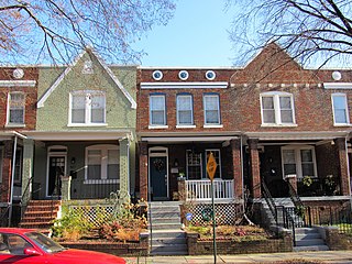
A terrace, terraced house (UK), or townhouse (US) is a kind of medium-density housing that first started in 16th century Europe with a row of joined houses sharing side walls. In the United States and Canada these are sometimes known as row houses or row homes.

Embassy Row is the informal name for a section of Northwest Washington, D.C., with a high concentration of embassies, diplomatic missions, and diplomatic residences. It spans Massachusetts Avenue N.W. between 18th and 35th street, bounded by Scott Circle to the south and the United States Naval Observatory to the north; the term is often applied to nearby streets and neighborhoods that also host diplomatic buildings, such as Kalorama.

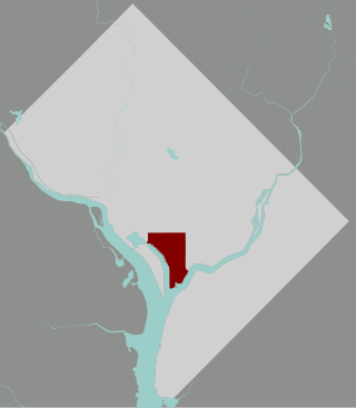
Southwest is the southwestern quadrant of Washington, D.C., the capital of the United States, and is located south of the National Mall and west of South Capitol Street. It is the smallest quadrant of the city, and contains a small number of named neighborhoods and districts, including Bellevue, Southwest Federal Center, the Southwest Waterfront, Buzzard Point, and the military installation known as Joint Base Anacostia–Bolling.

William Cranch was a United States circuit judge and chief judge of the United States Circuit Court of the District of Columbia. A staunch Federalist and nephew of President John Adams, Cranch moved his legal practice from Massachusetts to the new national capital, where he became one of three city land commissioners for Washington, D.C., and during his judicial service also was the 2nd Reporter of Decisions of the Supreme Court of the United States and a Professor of law at Columbian College.

L'Enfant Plaza is a complex of four commercial buildings grouped around a large plaza in the Southwest section of Washington, D.C., United States. Immediately below the plaza and the buildings is La Promenade shopping mall.
Kingman Park is a residential neighborhood in the Northeast quadrant of Washington, D.C., the United States capital city. Kingman Park's boundaries are 15th Street NE to the west; C Street SE to the south; Benning Road to the north; and Anacostia Park to the east. The neighborhood is composed primarily of two-story brick rowhouses. Kingman Park is named after Brigadier General Dan Christie Kingman, the former head of the United States Army Corps of Engineers.

Barney Circle is a small residential neighborhood located between the west bank of the Anacostia River and the eastern edge of Capitol Hill in southeast Washington, D.C., in the United States. The neighborhood is characterized by its sense of community, activism, walkability, and historic feel. The neighborhood's name derives from the eponymous former traffic circle Pennsylvania Avenue SE just before it crosses the John Philip Sousa Bridge over the Anacostia. The traffic circle is named for Commodore Joshua Barney, Commander of the Chesapeake Bay Flotilla in the War of 1812.
The Southwest Waterfront is a neighborhood in Southwest Washington, D.C. The Southwest quadrant is the smallest of Washington's four quadrants, and the Southwest Waterfront is one of only two residential neighborhoods in the quadrant; the other is Bellevue, which, being east of the Anacostia River, is frequently, if mistakenly, regarded as being in Southeast.

Greenway is a residential neighborhood in Southeast Washington, D.C., in the United States. The neighborhood is bounded by East Capitol Street SE, Interstate 295 SE, Fairlawn Avenue SE, Minnesota Avenue SE, Pennsylvania Avenue SE,

Marshall Heights is a residential neighborhood in Southeast Washington, D.C. It is bounded by East Capitol Street, Central Avenue SE, Southern Avenue, Fitch Street SE, and Benning Road SE. It was an undeveloped rural area occupied by extensive African American shanty towns, but the neighborhood received nationwide attention after a visit by First Lady Eleanor Roosevelt in 1934, which led to extensive infrastructure improvements and development for the first time. In the 1950s, Marshall Heights residents defeated national legislation designed to raze and redevelop the neighborhood. Queen Elizabeth II of the United Kingdom visited the area in 1991, at a time when Marshall Heights was in the throes of a violent crack cocaine epidemic. Limited redevelopment has occurred in the neighborhood, which was the site of two notorious child murders in 1973.

The Constitution Center, formerly known as the David Nassif Building, is an office building located at 400 7th Street SW in Washington, D.C. It is 140 feet (43 m) high and has 10 floors. Covering an entire city block, it is the largest privately owned office building in Washington, D.C. Current tenants include the Federal Housing Finance Agency and the Office of the Comptroller of the Currency. As of February 2014, Constitution Center was worth $725.8 million, making it the most valuable taxable property in the city.
Kingdon Gould III is an American real estate developer, active in the Washington, D.C.-area. He is part of the fifth generation of the Gould family of financiers, philanthropists and diplomats, which includes his father Kingdon Gould, Jr., grandfather Kingdon Gould Sr., great-grandfather George Jay Gould and great-great-grandfather Jay Gould, with associated generations of mothers, siblings, uncles, aunts and cousins.

P Street refers to four different streets within the city of Washington, D.C. The streets were named by President George Washington in 1791 as part of a general street naming program, in which east–west running streets were named alphabetically and north–south running streets numerically.

Friendship House is a Georgian townhouse, located at 619 D Street,, Southeast, Washington, D.C., in the Capitol Hill neighborhood.

Duncanson-Cranch House is an historic house, located at 468-470 N Street, Southwest, Washington, D.C.

O Street Market, also known as Northern Market, is a historic structure located at 1400 7th Street NW in the Shaw neighborhood of Washington, D.C. Built in 1881, it is one of three 19th-century public market buildings still standing in the city, along with Eastern Market and Georgetown Market. The market was listed on the District of Columbia Inventory of Historic Sites in 1968 and the National Register of Historic Places in 1995. The most distinctive architectural element of the Gothic Revival building is its corner tower on 7th and O Streets.

The James V. Forrestal Building is a low-rise Brutalist office building in Washington, D.C. Originally known as Federal Office Building 5, and nicknamed the Little Pentagon, the Forrestal Building was constructed between 1965 and 1969 to accommodate United States armed forces personnel. It is named after James Forrestal, the first United States Secretary of Defense. It became the headquarters of the United States Department of Energy after that agency's creation in 1977.

The Seven Buildings were seven townhouses constructed on the northwest corner of Pennsylvania Avenue NW and 19th Street NW in Washington, D.C., in 1796. They were some of the earliest residential structures built in the city. One of the Seven Buildings was the presidential home of President James Madison and his wife, Dolley, after the burning of the White House in 1814, and later the residence of Martin Van Buren shortly before and after his inauguration as president. Most of the buildings were demolished in 1959. The facades of two buildings were incorporated into the Embassy of Mexico in 1986.

James Greenleaf was a late 18th and early 19th century American land speculator responsible for the development of Washington, D.C., after the city was designated as the nation's capital following passage of the Residence Act in 1790. A member of a prominent and wealthy Boston family, he married a Dutch noblewoman, who he later abandoned and then divorced, and served briefly as consul at the United States embassy in Amsterdam.


