Whitmire, South Carolina

Last updated

Whitmire, South Carolina
Whitmire-Main-St-sc.jpg
Businesses along Main Street
Nickname: 
Pearl of the Piedmont
SCMap-doton-Whitmire.PNG
Location of Whitmire, South Carolina
Coordinates: 34°30′8″N81°36′51″W / 34.50222°N 81.61417°W / 34.50222; -81.61417
Country United States
State South Carolina
County Newberry
Area
[1]
  Total1.25 sq mi (3.24 km2)
  Land1.25 sq mi (3.24 km2)
  Water0.00 sq mi (0.00 km2)
Elevation
[2]
436 ft (133 m)
Population
 (2020) [3]
  Total1,390
  Density1,112.00/sq mi (429.38/km2)
Time zone UTC-5 (Eastern (EST))
  Summer (DST) UTC-4 (EDT)
ZIP code
29178
Area code(s) 803, 839
FIPS code 45-77380 [4]
GNIS feature ID1251440 [2]
Website townofwhitmire.godaddysites.com

Whitmire is a town in Newberry County, South Carolina, United States, along the Enoree River. The population was 1,441 at the 2010 census. The town was named for George Fredrick Whitmire, who came from Stuttgart, Germany.

Contents

History

The earliest settler in what is now Whitmire was John Duncan, who built a house along the creek that now bears his name. The George Frederick Whitmire family arrived prior to the 1790s (1790 Census) and established a tavern and post office. The arrival of the Georgia, Carolina and Northern Railway in 1890 led to the town's rapid growth. Whitmire incorporated in 1891. [5]

In 1902, William Coleman and several associates established a large textile factory known as the Glenn-Lowery Mill, which included 900 looms and 33,000 spindles. By 1911, the mill had nearly doubled in size. Later owners continued to expand the mill, and it would remain a major source of revenue for Whitmire throughout the 20th century. [5]

A fire in 1916 destroyed much of downtown Whitmire, which consisted primarily of wooden buildings. The town passed a series of new fire ordinances, and the business district was rebuilt with brick. Many of these buildings are still standing. [5]

In 1924, Whitmire attempted to "secede" from Newberry County and form a new county known as Carlisle County. The new county would have consisted of parts of Newberry County, Laurens County, and Union County, with Whitmire as the county seat. The county's organizers failed to acquire the necessary amount of land, however, and the initiative failed. [5]

Geography

Whitmire is located at 34°30′8″N81°36′51″W / 34.50222°N 81.61417°W / 34.50222; -81.61417 (34.502227, -81.614162). [6] The town is concentrated around the intersection of U.S. Route 176 and South Carolina Highway 72, northwest of Columbia and southeast of Spartanburg. The town's eastern boundary lies along the Enoree River.

According to the United States Census Bureau, the town has a total area of 1.3 square miles (3.3 km2), all land.

Demographics

Historical population
CensusPop.Note
1900 131
1910 1,045697.7%
1920 1,95587.1%
1930 2,76341.3%
1940 3,27218.4%
1950 3,006−8.1%
1960 2,663−11.4%
1970 2,226−16.4%
1980 2,038−8.4%
1990 1,702−16.5%
2000 1,512−11.2%
2010 1,441−4.7%
2020 1,390−3.5%
U.S. Decennial Census [7] [3]

As of the census [4] of 2010, there were 1,441 people, 597 households, and 382 families residing in the town. The population density was 1,147.0 people per square mile. There were 760 housing units at an average density of 617.4 per square mile (238.4/km2). The racial makeup of the town was 78.51% White, 20.50% African American, 0.07% Native American, 0.07% Asian, 0.07% Pacific Islander, 0.26% from other races, and 0.53% from two or more races. Hispanic or Latino of any race were 0.53% of the population.

There were 650 households, out of which 25.7% had children under the age of 18 living with them, 40.3% were married couples living together, 16.2% had a female householder with no husband present, and 37.7% were non-families. 34.5% of all households were made up of individuals, and 23.5% had someone living alone who was 65 years of age or older. The average household size was 2.30 and the average family size was 2.94.

In the town, the population was spread out, with 23.7% under the age of 18, 6.4% from 18 to 24, 22.7% from 25 to 44, 22.7% from 45 to 64, and 24.5% who were 65 years of age or older. The median age was 43 years. For every 100 females, there were 82.2 males. For every 100 females age 18 and over, there were 78.9 males.

The median income for a household in the town was $22,007, and the median income for a family was $30,833. Males had a median income of $27,500 versus $18,258 for females. The per capita income for the town was $13,429. About 16.3% of families and 18.7% of the population were below the poverty line, including 22.5% of those under age 18 and 15.1% of those age 65 or over.

Economy

Whitmire earned the title "Pearl of the Piedmont" for its status as a successful textile town, but by the early 2010s the last mill was closed. [8]

Education

Whitmire has a public library, a branch of the Newberry County Library System. [9]

Notable people

Related Research Articles

<span class="mw-page-title-main">Newberry County, South Carolina</span> County in South Carolina, United States

Newberry County is a county located in the U.S. state of South Carolina. As of the 2020 census, its population was 37,719. Its county seat is Newberry. The name is of unknown origin, although one theory suggests that it was named by Quaker settlers in honor of their home of Newberry, a suburb of London in the United Kingdom.

<span class="mw-page-title-main">Laurens County, South Carolina</span> County in South Carolina, United States

Laurens County is a county located in the U.S. state of South Carolina. As of the 2020 census, its population was 67,539. Its county seat is Laurens.

<span class="mw-page-title-main">Fairfield County, South Carolina</span> County in South Carolina, United States

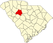
Fairfield County is a county located in the U.S. state of South Carolina. As of the 2020 census, its population was 20,948. Its county seat is Winnsboro.

<span class="mw-page-title-main">Newberry, Indiana</span> Town in Indiana, United States

Newberry is a town in Cass Township, Greene County, Indiana, United States. The population was 193 at the 2010 census. It is part of the Bloomington, Indiana Metropolitan Statistical Area.

<span class="mw-page-title-main">Lawndale, North Carolina</span> Town in North Carolina, United States

Lawndale is a town in Cleveland County, North Carolina, United States, situated along the First Broad River. The population was 606 at the 2010 census.

<span class="mw-page-title-main">Troy, North Carolina</span> Town in North Carolina, United States

Troy is a town in Montgomery County, North Carolina, United States. The population was 3,188 at the 2010 census. It is the county seat of Montgomery County. A short story by Charles W. Chesnutt, The Sheriff's Children, is set in Troy.

<span class="mw-page-title-main">East Laurinburg, North Carolina</span> Unincorporated community in North Carolina, United States

East Laurinburg is an unincorporated community in Scotland County, North Carolina, United States. The population was 345 at the 2020 census. The town was incorporated in 1903 but, due to financial improprieties and failing finances, the town's charter was revoked by the state effective June 30, 2022, in which the area became an unincorporated part of Scotland County.

<span class="mw-page-title-main">Winnsboro, South Carolina</span> Town in South Carolina, United States

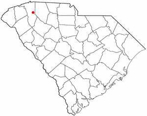
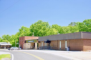
Winnsboro is a town in Fairfield County, South Carolina, United States. The population was 3,550 at the 2010 census. The population was 3,215 at the 2020 census, a population decrease of approximately 9.5% for the same 10 year period. It is the county seat of Fairfield County. Winnsboro is part of the Columbia, South Carolina metropolitan Area as well as a suburb of Columbia.

<span class="mw-page-title-main">Winnsboro Mills, South Carolina</span> Census-designated place in South Carolina, United States

Winnsboro Mills is an unincorporated community and census-designated place (CDP) in Fairfield County, South Carolina, United States. The population was 1,898 at the 2010 census, down from 2,263 at the 2000 census. It is part of the Columbia, South Carolina Metropolitan Statistical Area.

<span class="mw-page-title-main">Taylors, South Carolina</span> CDP in South Carolina, United States

Taylors is a census-designated place (CDP) in Greenville County, South Carolina, United States. The population was 23,222 at the 2020 census. It is part of the Greenville–Mauldin–Easley Metropolitan Statistical Area.

<span class="mw-page-title-main">Joanna, South Carolina</span> Census-designated place in South Carolina, United States

Joanna is an unincorporated community and census-designated place (CDP) in Laurens County, South Carolina, United States. The population was 1,539 at the 2010 census, down from 1,609 at the 2000 census. It is part of the Greenville–Mauldin–Easley Metropolitan Statistical Area.

<span class="mw-page-title-main">Watts Mills, South Carolina</span> Census-designated place in South Carolina, United States

Wattsville is an unincorporated community in Laurens County, South Carolina, United States. The town name is derived from Watts Mill, a textile mill in the center of town. The area is listed as the Wattsville census-designated place (CDP) for statistical purposes. The population of the CDP was 1,635 at the 2010 census. It is part of the Greenville–Mauldin–Easley Metropolitan Statistical Area.

<span class="mw-page-title-main">Newberry, South Carolina</span> City in South Carolina, United States

Newberry is a city in Newberry County, South Carolina, United States, in the Piedmont 43 miles northwest of Columbia. The charter was adopted in 1894. The population was 10,277 at the 2010 census. It is the county seat of Newberry County; at one time it was called Newberry Courthouse.

<span class="mw-page-title-main">Peak, South Carolina</span> Town in South Carolina, United States

Peak is a town in Newberry County, South Carolina, United States. The population was 64 at the 2010 census.

<span class="mw-page-title-main">Pomaria, South Carolina</span> Town in South Carolina, United States

Pomaria is a town in Newberry County, South Carolina, United States. The population was 179 at the 2010 census.

<span class="mw-page-title-main">Prosperity, South Carolina</span> Town in South Carolina, United States

Prosperity is a town in Newberry County, South Carolina, United States. The population was 1,178 at the 2020 U.S. census.

<span class="mw-page-title-main">Silverstreet, South Carolina</span> Town in South Carolina, United States

Silverstreet is a town in Newberry County, South Carolina, United States. The population was 162 at the 2010 census. Arguably its biggest tourist attraction is its Thunderbolt siren, tested on the 4th Saturday of every month for three minutes, and one of the only active Thunderbolts left In the state of South Carolina. With there only being five others remaining.

<span class="mw-page-title-main">Lyman, South Carolina</span> Town in South Carolina, United States

Lyman is a town in Spartanburg County, South Carolina, United States. Its population was 6,173 at the 2020 census.

<span class="mw-page-title-main">Honea Path, South Carolina</span> Town in South Carolina, United States

Honea Path is a town primarily in Anderson County, South Carolina and extending into Abbeville County in the northwest part of the state. The population was 3,686 at the 2020 census.

<span class="mw-page-title-main">Piedmont, South Carolina</span> CDP in South Carolina, United States

Piedmont is a census-designated place (CDP) along the Saluda River in Anderson and Greenville counties in the U.S. state of South Carolina. The population was 5,411 at the 2020 census.

References

  1. "ArcGIS REST Services Directory". United States Census Bureau. Retrieved October 15, 2022.
  2. 1 2 U.S. Geological Survey Geographic Names Information System: Whitmire, South Carolina
  3. 1 2 "Census Population API". United States Census Bureau. Retrieved October 15, 2022.
  4. 1 2 "U.S. Census website". United States Census Bureau . Retrieved January 31, 2008.
  5. 1 2 3 4 Jennifer Revels, "Historical and Architectural Survey of Newberry County, South Carolina," 2003, pp. 52-54.
  6. "US Gazetteer files: 2010, 2000, and 1990". United States Census Bureau. February 12, 2011. Retrieved April 23, 2011.
  7. "Census of Population and Housing". Census.gov. Retrieved June 4, 2015.
  8. Collins, Jeffrey (April 28, 2011). "Troubles in Whitmire: Plant closure, recession hit textile town hard". The Post and Courier. Retrieved June 13, 2019.
  9. "Locations & Hours". Greenville County Library System. Retrieved June 13, 2019.