Related Research Articles

Charles Lee Tilden Regional Park, also known as Tilden Park or Tilden, [], is a 2,079-acre (841 ha) regional park in the East Bay, part of the San Francisco Bay Area in California. It is between the Berkeley Hills and San Pablo Ridge. Its main entrance is near Kensington, Berkeley, and Richmond. The park is contiguous with Wildcat Canyon Regional Park.

Claremont Canyon Regional Preserve is a small regional park mainly located in the city of Oakland, California, and administered by the East Bay Regional Park District. The park is named for the canyon in which it is situated, Claremont Canyon, out of which Claremont Creek flows on its way to its confluence with Temescal Creek. Originally, the canyon was named Harwood's Canyon, and then later as Telegraph Canyon. The name was changed to Claremont by a developer of the nearby Claremont district.

Bernard Ralph Maybeck was an American architect in the Arts and Crafts Movement of the early 20th century. He was an instructor at University of California, Berkeley. Most of his major buildings were in the San Francisco Bay Area.

Montclair is a hillside neighborhood in Oakland, California, United States. Montclair is located along the western slope of the Oakland Hills from a valley formed by the Hayward Fault to the upper ridge of the hills.

Northside is a principally residential neighborhood in Berkeley, California, located north of the University of California, Berkeley campus, east of Oxford Street, and south of Cedar Street. There is a small shopping area located at Euclid and Hearst Avenues, at the northern entrance to the university. The Graduate Theological Union is located one block west of Euclid Avenue, in an area nicknamed Holy Hill. The north fork of Strawberry Creek runs southwestward across Northside, mostly culverted under buildings and pavement, to the campus.

The Berkeley Hills are a range of the Pacific Coast Ranges that overlook the northeast side of the valley that encompasses San Francisco Bay. They were previously called the "Contra Costa Range/Hills", but with the establishment of Berkeley and the University of California, the current usage was applied by geographers and gazetteers.

Temescal Creek is one of the principal watercourses in the city of Oakland, California, United States.

La Loma Park is a neighborhood and tract of land located in the Berkeley Hills section of the city of Berkeley, California in the San Francisco Bay Area. The land had been the property of Captain Richard Parks Thomas, a veteran of the American Civil War and Berkeley businessman. Today, it is entirely a residential area The Spanish word loma means "rise/low hill". Although hilly throughout, its average elevation is about 614 feet (187 m).

Schoolhouse Creek is a creek which flows through the city of Berkeley, California in the San Francisco Bay Area.

Wildcat Canyon Regional Park is a 2,789-acre (1,129 ha) East Bay Regional Parks District park bordering the city of Richmond in Contra Costa County in the San Francisco Bay Area of California. It includes a portion of Wildcat Canyon as well as a portion of the adjoining San Pablo Ridge, and is directly connected to the more heavily used Tilden Regional Park.
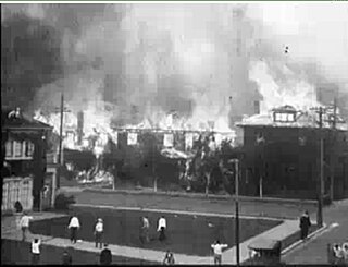
The 1923 Berkeley, California, fire was a conflagration that consumed some 640 structures, including 584 houses in the densely built neighborhoods north of the campus of the University of California in Berkeley, California, on September 17, 1923.

Sanborn County Park is a 3,453 acre (13.97 km2) county park situated in the Santa Cruz Mountains, managed by the Santa Clara County Parks and Recreation Department. The deeply forested park features over 15 miles of trails, second-growth redwoods, and creeks that flow year-round. It offers hiking, RV camping, walk-in campsites, and picnicking/BBQ sites. In the summer months, Sanborn County Park hosts the only outdoor Shakespearean company in Silicon Valley.

The San Pablo Reservoir is an open cut terminal water storage reservoir owned and operated by the East Bay Municipal Utility District (EBMUD). It is located in the valley of San Pablo Creek, north of Orinda, California, United States, and south of El Sobrante and Richmond, east of the Berkeley Hills between San Pablo Ridge and Sobrante Ridge.
Las Trampas Regional Wilderness is a 5,342-acre (21.62 km2) regional park located in Alameda and Contra Costa counties in Northern California. The nearest city is Danville, California. Las Trampas is Spanish for the traps, or the snares. The park belongs to the East Bay Regional Park District (EBRPD).

Wildcat Creek is a 13.4-mile-long (21.6 km) creek which flows through Wildcat Canyon situated between the Berkeley Hills and the San Pablo Ridge, emptying into San Pablo Bay in Contra Costa County, northern California.

San Pablo Creek is an 18.7-mile-long (30.1 km) creek in Contra Costa County, California, United States, which drains the canyon or valley between the San Pablo Ridge and the Sobrante Ridge, parts of the Pacific Coast Ranges east of San Francisco Bay.
San Pablo Ridge is a small mountain range in western Contra Costa County from Pinole to Orinda between Wildcat Canyon and San Pablo Canyon. The western flank is part of the Wildcat Creek watershed and the eastern flank is part of the San Pablo Creek watershed. To the west are the Berkeley Hills, and to the east, the Sobrante Ridge. The highest point on the San Pablo Ridge is Vollmer Peak, formerly called "Bald Peak", located near the point where it meets the Berkeley Hills at the head of Wildcat Canyon.

Oakland Hills is an informal term used to indicate the city neighborhoods lying within the eastern portion of Oakland, California. The northernmost neighborhoods were devastated by the Oakland firestorm of 1991.

Jewel Lake is a former reservoir and artificial lake along Wildcat Creek, a small stream in Northern California in Tilden Regional Park. It is located in the Wildcat Canyon between the Berkeley Hills and Sobrante Ridge Hills in an unincorporated area closest to Richmond and Kensington, California geographically and Berkeley accessibly. A wooden raised walkway built in the 1970s runs over marshland to the south of the lake. The dam and abandoned flood control machinery are visible at the north end of the lake.

Monte Bello Open Space Preserve is a 3,133-acre (12.68 km2) open space preserve, located near Palo Alto in the Santa Cruz Mountains, in San Mateo and Santa Clara Counties, California, United States. The preserve encompasses the upper Stevens Creek watershed in the valley between Monte Bello Ridge and Skyline Ridge. "Monte Bello" means "beautiful mountain" in Italian, and refers to Black Mountain which is the highest part of Montebello Ridge. The straight valley of upper Stevens Creek is also the rift valley of the San Andreas Fault.
References
- ↑ Biswell, Harold (2023-11-15). Prescribed Burning in California Wildlands Vegetation Management. Univ of California Press. pp. 66–67. ISBN 978-0-520-35406-7.
- ↑ Wilson, Mark Anthony; Maybeck, Bernard R. (2011). Bernard Maybeck: Architect of Elegance. Gibbs Smith. p. 206. ISBN 978-1-4236-1180-6.