Willow Springs, Missouri

Last updated

Willow Springs, Missouri
Willow-Springs-Main-St-mo.jpg
Main Street
Howell County Missouri Incorporated and Unincorporated areas Willow Springs Highlighted.svg
Location of Willow Springs, Missouri
Coordinates: 36°59′15″N91°57′46″W / 36.98750°N 91.96278°W / 36.98750; -91.96278
Country United States
State Missouri
County Howell
Area
[1]
  Total3.77 sq mi (9.77 km2)
  Land3.76 sq mi (9.73 km2)
  Water0.02 sq mi (0.04 km2)
Elevation
[2]
1,227 ft (374 m)
Population
 (2020)
  Total2,164
  Density575.84/sq mi (222.31/km2)
Time zone UTC-6 (Central (CST))
  Summer (DST) UTC-5 (CDT)
ZIP code
65793
Area code 417
FIPS code 29-80098 [3]
GNIS feature ID2397325 [2]
Website www.willowspringsmo.com

Willow Springs is a city in Howell County, Missouri, in the Ozark Mountains of the United States. The population was 2,164 at the 2020 census.

Contents

History

Willow Springs was so named from its position at the site of a spring, surrounded by willows. [4]

Geography

According to the United States Census Bureau, the city has a total area of 3.55 square miles (9.19 km2), of which 3.53 square miles (9.14 km2) is land and 0.02 square miles (0.05 km2) is water. [5]

The community is located on Route 137, east of concurrent U.S. Routes 60 and 63.

Demographics

Historical population
CensusPop.Note
1890 1,535
1900 1,078−29.8%
1910 1,40130.0%
1920 1,4412.9%
1930 1,430−0.8%
1940 1,5307.0%
1950 1,91425.1%
1960 1,913−0.1%
1970 2,0456.9%
1980 2,2158.3%
1990 2,038−8.0%
2000 2,1475.3%
2010 2,1841.7%
2020 2,164−0.9%
U.S. Decennial Census [6]

2010 census

As of the census [7] of 2010, there were 2,184 people, 925 households, and 564 families living in the city. The population density was 618.7 inhabitants per square mile (238.9/km2). There were 1,082 housing units at an average density of 306.5 per square mile (118.3/km2). The racial makeup of the city was 96.11% White, 0.14% Black or African American, 0.41% Native American, 0.73% Asian, 0.46% from other races, and 2.15% from two or more races. Hispanic or Latino of any race were 2.06% of the population.

There were 925 households, of which 31.5% had children under the age of 18 living with them, 42.3% were married couples living together, 13.7% had a female householder with no husband present, 5.0% had a male householder with no wife present, and 39.0% were non-families. 35.1% of all households were made up of individuals, and 18.3% had someone living alone who was 65 years of age or older. The average household size was 2.36 and the average family size was 2.94.

The median age in the city was 38.6 years. 26.6% of residents were under the age of 18; 8.1% were between the ages of 18 and 24; 23.2% were from 25 to 44; 21.1% were from 45 to 64; and 21.1% were 65 years of age or older. The gender makeup of the city was 47.1% male and 52.9% female.

2000 census

As of the census [3] of 2000, there were 2,147 people, 913 households, and 545 families living in the city. The population density was 654.9 inhabitants per square mile (252.9/km2). There were 1,033 housing units at an average density of 315.1 per square mile (121.7/km2). The racial makeup of the city was 97.02% White, 0.37% African American, 0.84% Native American, 0.28% Asian, and 1.49% from two or more races. Hispanic or Latino of any race were 1.07% of the population.

There were 913 households, out of which 27.6% had children under the age of 18 living with them, 46.8% were married couples living together, 10.5% had a female householder with no husband present, and 40.3% were non-families. 36.0% of all households were made up of individuals, and 22.3% had someone living alone who was 65 years of age or older. The average household size was 2.21 and the average family size was 2.89.

In the city the population was spread out, with 23.5% under the age of 18, 7.7% from 18 to 24, 22.6% from 25 to 44, 19.2% from 45 to 64, and 27.0% who were 65 years of age or older. The median age was 42 years. For every 100 females, there were 82.6 males. For every 100 females age 18 and over, there were 73.3 males.

The median income for a household in the city was $19,894, and the median income for a family was $25,917. Males had a median income of $22,357 versus $16,316 for females. The per capita income for the city was $13,681. About 20.8% of families and 26.0% of the population were below the poverty line, including 41.4% of those under age 18 and 17.0% of those age 65 or over.

Education

Public education in Willow Springs is administered by Willow Springs R-IV School District. [8]

Willow Springs has a lending library, the Willow Springs Public Library. [9]

Notable people

Related Research Articles

<span class="mw-page-title-main">Bogard, Missouri</span> City in Missouri, United States

Bogard is a city in Carroll County, Missouri, United States. The population was 167 at the 2020 census.

<span class="mw-page-title-main">Kearney, Missouri</span> City in Missouri, United States

Kearney is a city in Clay County, Missouri, United States. The population per the 2020 U.S. Census was 10,404. The city was the birthplace of Jesse James, and there is an annual festival in the third weekend of September to recognize the outlaw. It is part of the Kansas City metropolitan area.

<span class="mw-page-title-main">Berger, Missouri</span> City in Missouri, United States

Berger is a city in northwest Franklin County, Missouri, United States, located south of the Missouri River. The population was 256 at the 2020 census.

<span class="mw-page-title-main">Urich, Missouri</span> City in Missouri, United States

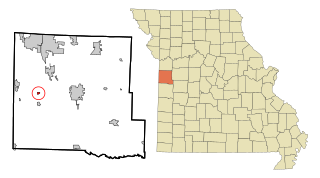
Urich is a city in Henry County, Missouri, United States. The population was 505 at the 2010 census.

<span class="mw-page-title-main">Mountain View, Missouri</span> City in Missouri, United States

Mountain View is a city in northeastern Howell County, Missouri, United States. The population was 2,533 at the 2020 census.

<span class="mw-page-title-main">Lake Tapawingo, Missouri</span> City in Missouri, United States

Lake Tapawingo is a city in Jackson County, Missouri, United States. The population was 730 at the 2010 census.

<span class="mw-page-title-main">Oronogo, Missouri</span> City in Missouri, United States

Oronogo is a city in Jasper County, Missouri, United States. The population was 2,558 at the 2020 census. It is part of the Joplin, Missouri Metropolitan Statistical Area.

<span class="mw-page-title-main">Linneus, Missouri</span> City in Missouri, United States

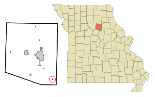
Linneus is a small city in Linn County, Missouri, United States. The population was 281 at the 2020 census. It is the county seat of Linn County.

<span class="mw-page-title-main">Elmer, Missouri</span> City in Missouri, United States

Elmer is a city in Macon County, Missouri, United States. The population was 51 at the 2020 census.

<span class="mw-page-title-main">Ravenwood, Missouri</span> City in Missouri, United States

Ravenwood is a city in eastern Nodaway County, Missouri, United States, near the Platte River. The population was 439 at the 2020 census.

<span class="mw-page-title-main">Hayti Heights, Missouri</span> City in Missouri, United States

Hayti Heights is a city in eastern Pemiscot County in the bootheel of southeast Missouri, United States. The population was 515 at the 2020 census.

<span class="mw-page-title-main">Bolivar, Missouri</span> City in Missouri, United States

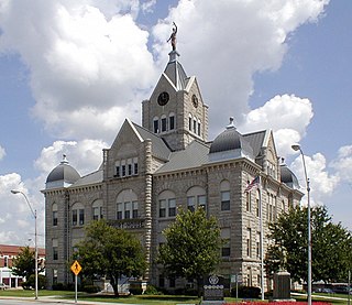
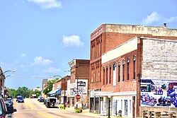
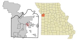
Bolivar is a city and county seat of Polk County, Missouri, United States.

<span class="mw-page-title-main">Nelson, Missouri</span> City in Missouri, United States

Nelson is a city in Saline County, Missouri, United States. The population was 152 at the 2020 census.

<span class="mw-page-title-main">Benton, Missouri</span> City in Missouri, United States

Benton is a city in Scott County, Missouri, United States. The population was 863 at the 2010 census. It is the county seat of Scott County.

<span class="mw-page-title-main">Manchester, Missouri</span> City in Missouri, United States

Manchester is a city in St. Louis County, Missouri, United States. The population was 18,333 at the 2020 census.

<span class="mw-page-title-main">Winchester, Missouri</span> City in Missouri, United States

Winchester is a city in St. Louis County, Missouri, United States. The population was 1,447 at the 2020 census.

<span class="mw-page-title-main">Lake Annette, Missouri</span> City in Missouri, United States

Lake Annette is a city in Cass County, Missouri, United States. The population was 100 at the 2010 census. It is part of the Kansas City metropolitan area.

<span class="mw-page-title-main">Lock Springs, Missouri</span> Village in Missouri, United States

Lock Springs is a village in southeast Daviess County, Missouri, United States. The population was 40 at the 2020 census.

<span class="mw-page-title-main">Clark, Missouri</span> City in Missouri, United States

Clark is a city in Randolph County, Missouri, United States. The population was 298 at the 2010 census.

<span class="mw-page-title-main">Clarkson Valley, Missouri</span> City in Missouri, United States

Clarkson Valley is a city in St. Louis County, Missouri, United States. The population was 2,609 at the 2020 census.

References

  1. "ArcGIS REST Services Directory". United States Census Bureau. Retrieved August 28, 2022.
  2. 1 2 U.S. Geological Survey Geographic Names Information System: Willow Springs, Missouri
  3. 1 2 "U.S. Census website". United States Census Bureau . Retrieved January 31, 2008.
  4. Eaton, David Wolfe (1916). How Missouri Counties, Towns and Streams Were Named. The State Historical Society of Missouri. pp.  176.
  5. "US Gazetteer files 2010". United States Census Bureau . Retrieved July 8, 2012.
  6. "Census of Population and Housing". Census.gov. Retrieved June 4, 2015.
  7. "U.S. Census website". United States Census Bureau . Retrieved July 8, 2012.
  8. "Homepage". Willow Springs R-Iv School District. Retrieved June 5, 2019.
  9. "Missouri Public Libraries". PublicLibraries.com. Archived from the original on June 10, 2017. Retrieved June 5, 2019.
  10. Washington Post - National Geographic Writer and Editor Cecil Rowe Findley