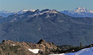
The Cascade Range or Cascades is a major mountain range of western North America, extending from southern British Columbia through Washington and Oregon to Northern California. It includes both non-volcanic mountains, such as many of those in the North Cascades, and the notable volcanoes known as the High Cascades. The small part of the range in British Columbia is referred to as the Canadian Cascades or, locally, as the Cascade Mountains. The highest peak in the range is Mount Rainier in Washington at 14,411 feet (4,392 m).

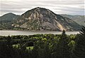
The Columbia River Gorge is a canyon of the Columbia River in the Pacific Northwest of the United States. Up to 4,000 feet (1,200 m) deep, the canyon stretches for over eighty miles (130 km) as the river winds westward through the Cascade Range, forming the boundary between the state of Washington to the north and Oregon to the south. Extending roughly from the confluence of the Columbia with the Deschutes River in the east down to the eastern reaches of the Portland metropolitan area, the water gap furnishes the only navigable route through the Cascades and the only water connection between the Columbia Plateau and the Pacific Ocean. It is thus that the routes of Interstate 84, U.S. Route 30, Washington State Route 14, and railroad tracks on both sides run through the gorge.

The Yacolt Burn is the collective name for dozens of fires in Washington state and Oregon occurring between September 8 and September 12, 1902, causing 38 deaths in the Lewis River area, at least nine deaths by fire in Wind River and 18 deaths in the Columbia River Gorge.

Huckleberry Mountain is a 6,320+ ft summit located on the shared border of King County and Kittitas County in Washington state.

Naches Peak is a 6,452-foot mountain summit located on the shared border of Mount Rainier National Park and William O. Douglas Wilderness. It is also on the shared border of Pierce County and Yakima County in Washington state. Naches Peak is situated on the crest of the Cascade Range and immediately southeast of Chinook Pass. Its nearest higher neighbor is Tahtlum Peak, 1.45 mi (2.33 km) to the east. The name Naches Peak was proposed by the Yakima Chamber of Commerce and approved by Asahel Curtis in 1927. The Naches Peak Loop Trail is a popular 3.5 mile trail encircling the peak. Precipitation runoff from the west side of Naches Peak drains into Chinook Creek, which is a tributary of the Ohanapecosh River, whereas the east side drains into tributaries of the American River.

Tamanos Mountain is a 6,790-foot (2,070 m) summit located in Mount Rainier National Park in Pierce County of Washington state. It is part of the Cascade Range. Tamanos Mountain is situated west of Governors Ridge and northeast of the Cowlitz Chimneys, all of which can be seen from the Sunrise Historic District. The name tamanos derives from Chinook Jargon and has the meaning of guardian spirit. This landform's toponym was officially adopted by the U.S. Board on Geographic Names in 1932. Topographic relief is significant as the summit rises 3,100 feet above the White River in approximately 1.5 mile. The normal climbing access is from the Owyhigh Lakes Trail, and from the lakes scrambling up the south slope to the summit.
Hidden Lake Peaks is series of peaks with a maximum elevation of 7,088 feet that are located in the North Cascades, in Skagit County of Washington state. The peaks extend three miles southwest from the nearest higher peak called The Triad. Situated on the western boundary of North Cascades National Park, Hidden Lake Peaks are positioned west of the crest of the Cascade Range, approximately ten miles east of the town of Marblemount. The popular subsidiary peak, Hidden Lake Lookout (6890 ft), lies a half mile to the southwest of the highest summit. The mountain's name is taken from its proximity to Hidden Lake which lies in a cirque below the east aspect of these two main peaks. Precipitation runoff from Hidden Lake Peaks drains into Cascade River which is a tributary of the Skagit River.

Crystal Peak is a 6,595-foot summit located in eastern Mount Rainier National Park, in Pierce County of Washington state. Crystal Peak is situated 0.75 mi (1.21 km) northwest of Chinook Peak, and nearly on the crest of the Cascade Range. Crystal Mountain and Crystal Lakes lie immediately to the northeast, and Three Way Peak is 1.09 mi (1.75 km) to the east. Access to the summit is via a hiking trail which branches off from the Crystal Lakes Trail. That trailhead starts along Highway 410, which traverses the western base of the mountain. Precipitation runoff from Crystal Peak drains into tributaries of the White River.
Mother Mountain is a 6,480+ ft multi-summit, 3-mile long ridge-like mountain located in Mount Rainier National Park, in Pierce County of Washington state. It is part of the Cascade Range, and lies 7 mi (11 km) northwest of the summit of Mount Rainier. The Wonderland Trail provides one approach option to this mountain, and the summit offers views of Mount Rainier. East Fay Peak is its nearest higher neighbor, 0.42 mi (0.68 km) to the south. Precipitation runoff from Mother Mountain is drained by Cataract Creek on the south side of the mountain, and Ipsut Creek drains the north side of it, and both are tributaries of the Carbon River. The west side drains into Mowich Lake, and thence Mowich River.
Hock Mountain is a 7,750-foot-elevation summit located in the Methow Mountains, a subset of the North Cascades in Washington state. It is situated on the triple-shared boundary of North Cascades National Park, Lake Chelan-Sawtooth Wilderness, and Lake Chelan National Recreation Area, as well as the shared border between Chelan County and Okanogan County. Additionally, it lies one mile southwest of Twisp Mountain, and 2.24 miles (3.60 km) due south of Stiletto Peak, the nearest higher neighbor. The north face is steep, granitic rock, but the west slope is more moderate, allowing a scramble ascent. Precipitation runoff from the north and west sides of Hock drains to the Stehekin River via Bridge Creek, whereas the south and east sides of the mountain drain into the South Fork Twisp River.

Tumtum Peak is a 4,678-foot-elevation (1,426-meter) mountain summit located in the southwest corner of Mount Rainier National Park, in Pierce County of Washington state. This top-to-bottom forested peak is part of the Cascade Range and lies 8.7 mi (14.0 km) southwest of the summit of Mount Rainier. The nearest higher neighbor is Mount Wow, 2.2 mi (3.5 km) to the northwest, and Iron Mountain rises 3.56 mi (5.73 km) to the northeast. Precipitation runoff from Tumtum Peak is drained by Tahoma Creek on the west side of the mountain, whereas Kautz Creek drains the east side, and both are tributaries of the Nisqually River. The Road to Paradise traverses the southern base of the peak shortly after visitors to the park enter via the Nisqually Entrance. Topographic relief is significant as the southwest aspect rises nearly 2,500 feet above the road in one mile.
Mount Watson is a 6,220-foot-elevation (1,900-meter) summit located in the North Cascades, in Whatcom County of Washington state.

Painted Mountain is a 6,975-foot-elevation (2,126-meter) summit located in the North Cascades, in Snohomish County of Washington state. The mountain is situated in the Glacier Peak Wilderness on land managed by Mount Baker-Snoqualmie National Forest. Neighbors include line parent Black Mountain, 2.2 mi (3.5 km) to the east, and Glacier Peak is 7 mi (11 km) to the northeast. Precipitation runoff from the peak drains west into tributaries of the North Fork Sauk River. Topographic relief is significant as the summit rises nearly 5,000 feet above the river in less than two miles.
Bedal Peak is a 6,554-foot-elevation (1,998-meter) mountain summit located in the North Cascades, in Snohomish County of Washington state. The mountain is situated in the Henry M. Jackson Wilderness, on land managed by Mount Baker-Snoqualmie National Forest. The nearest higher neighbor is line parent Sloan Peak, 2 mi (3.2 km) to the south-southeast. Precipitation runoff from the peak drains west to the South Fork Sauk River via Bedal Creek, as well as north and east into tributaries of the North Fork. The north and south forks merge at the northwest base of the mountain to form the Sauk River. Topographic relief is significant as the summit rises 5,250 feet above the Sauk River Valley and Mountain Loop Highway in approximately two miles.

Kelly Butte is a 5,417-foot-elevation (1,651-meter) summit located in the southeast corner of King County in Washington state. It is set on land managed by Mount Baker-Snoqualmie National Forest. It is situated 3.1 mi (5.0 km) northwest of Colquhoun Peak and five miles west of the crest of the Cascade Range. Precipitation runoff from Kelly Butte drains into tributaries of the Green River. Topographic relief is significant as the west aspect rises 3,000 feet above Rock Creek in one mile. Access is via the 1.7-mile Kelly Butte Trail which leads to a restored, historical fire lookout tower originally constructed in 1926 and occupies the summit. Flora along the trail includes lilies, bear grass, Indian paintbrush, penstemon, arnica, columbine, lupine, phlox, and huckleberry. This geographical feature's name has been officially adopted by the U.S. Board on Geographic Names.

Glee Peak is a 7,180-foot-elevation (2,190-meter) mountain summit located in Whatcom County of Washington state, United States. It is set within North Cascades National Park and Stephen Mather Wilderness, where it is situated 1.7 mile north of The Roost and one mile south of Azure Lake. The nearest higher neighbor is McMillan Spire, 1.7 miles (2.7 km) to the north-northwest. Glee Peak is part of the Picket Range which is a sub-range of the North Cascades, and like many North Cascades peaks, it is more notable for its large, steep rise above local terrain than for its absolute elevation. Topographic relief is significant as the northeast aspect rises 4,000 feet above Stetattle Creek in approximately one mile, and the southwest aspect rises 6,000 feet above Goodell Creek in three miles. Precipitation runoff from the mountain drains into these two creeks which are both tributaries of the Skagit River. Who made the first ascent of the summit is unknown, but Glee Davis and Burton Babcock were climbing in the immediate area as early as 1905.

Tinkham Peak is a double summit mountain located on the common boundary of King County and Kittitas County in Washington state.

Mailbox Peak is a 4,841-foot-elevation (1,476 m) mountain located in King County of Washington state. It is set west of the crest of the Cascade Range, on land managed by Mount Baker-Snoqualmie National Forest. Mailbox Peak is situated seven miles east of North Bend, and one mile northeast above the Washington State Fire Training Academy. Precipitation runoff from the south side of the mountain drains into the South Fork Snoqualmie River, whereas the north side drains to the Middle Fork of the Snoqualmie. The summit lies along a ridge containing Dirtybox Peak, its topographical parent, and Dirty Harry's Peak. Topographic relief is significant as the northwest aspect rises nearly 4,100 feet above the Middle Fork in 1.25 mile. The popular Mailbox Peak Trail gains 4,100 feet of elevation over 5.5 miles. Prior to 2014 when the new trail was completed, climbing Mailbox Peak involved 4,000 feet gain in only 2.6 miles along an unmaintained route that was used for conditioning for major climbs, and recruits from the Fire Training Academy would celebrate graduation by carrying a fire hydrant to the summit. The peak is named for a mailbox at the top which functions as the summit register, but this toponym has not been officially adopted by the U.S. Board on Geographic Names.

French Cabin Mountain is a triple-peak mountain located in Kittitas County of Washington state. The highest summit is West Peak, elevation 5,724-feet, the South Peak is 5,560-feet-elevation, and the North Peak is 5,498-feet. French Cabin Mountain is situated six miles north of Easton, between Kachess Lake and Cle Elum Lake, on land managed by Okanogan-Wenatchee National Forest. Precipitation runoff from the mountain drains north into French Cabin Creek and south into Silver Creek, which are both part of the Yakima River drainage basin. Topographic relief is significant as the summit rises 1,700 feet above Silver Creek in one mile, and the east aspect rises 3,400 feet above Cle Elum Lake in one and a half miles (2.4 km). French Cabin Mountain is the toponym officially adopted by the U.S. Board on Geographic Names, however "Frenchman Mountain" is a variant. West Peak is also an official toponym.

Wedge Mountain is a 5,860-foot-elevation (1,786-meter) summit located in Chelan County of Washington state. It is set on the boundary line of the Alpine Lakes Wilderness, on land managed by Okanogan-Wenatchee National Forest. Wedge Mountain is the northeastern terminus of the Stuart Range, which is a subset of the Cascade Range. It is situated 3.5 miles (5.6 km) northeast of The Temple, and the nearest town is Leavenworth, 5 miles (8.0 km) to the north-northeast. Precipitation runoff from the mountain drains into tributaries of the Wenatchee River. Topographic relief is significant as the summit rises over 2,800 feet above Snow Creek in one-half mile. Backpackers hiking en route to The Enchantments via the Snow Creek Trail traverse the western foot of this mountain. Wedge Mountain is the toponym officially adopted by the U.S. Board on Geographic Names for the 5,860-foot summit.