Winterville, Georgia | |
---|---|
Nickname(s): The Marigold Capital of Georgia, the Friendship City [1] | |
Coordinates: 33°58′00″N83°16′53″W / 33.96667°N 83.28139°W | |
Country | United States |
State | Georgia |
County | Clarke |
Incorporated | 1904 [1] |
Area | |
• Total | 2.65 sq mi (6.85 km2) |
• Land | 2.62 sq mi (6.78 km2) |
• Water | 0.03 sq mi (0.07 km2) |
Elevation | 797 ft (243 m) |
Population (2020) | |
• Total | 1,202 |
• Density | 458.40/sq mi (177.01/km2) |
Time zone | UTC-5 (Eastern (EST)) |
• Summer (DST) | UTC-4 (EDT) |
ZIP code | 30683 |
Area code | 706 |
FIPS code | 13-83728 [4] |
GNIS feature ID | 2405776 [3] |
Website | cityofwinterville.com |
Winterville is a village in Clarke County, Georgia, United States. The population was 1,122 at the 2010 census. [5]
The community was named after John Winter, a railroad official. [6] Winterville was incorporated in 1904. [7]
Since 1991, when the City of Athens dissolved its city charter to form the unified government of Athens-Clarke County, Winterville has been the only municipality located wholly within Athens-Clarke County.
Winterville is located at 33°58′00″N83°16′54″W / 33.966720°N 83.281669°W , [8] a 6-mile (10 km)–drive from the University of Georgia. [1] According to the United States Census Bureau, the city has a total area of 2.7 square miles (7.0 km2), all land.
Climate data for Winterville, Georgia, 1991–2020 normals, extremes 1999–2021 | |||||||||||||
---|---|---|---|---|---|---|---|---|---|---|---|---|---|
Month | Jan | Feb | Mar | Apr | May | Jun | Jul | Aug | Sep | Oct | Nov | Dec | Year |
Record high °F (°C) | 79 (26) | 80 (27) | 89 (32) | 91 (33) | 98 (37) | 107 (42) | 106 (41) | 101 (38) | 97 (36) | 97 (36) | 83 (28) | 78 (26) | 107 (42) |
Mean maximum °F (°C) | 70.3 (21.3) | 74.7 (23.7) | 83.2 (28.4) | 85.9 (29.9) | 89.3 (31.8) | 95.3 (35.2) | 95.2 (35.1) | 94.5 (34.7) | 90.9 (32.7) | 84.7 (29.3) | 76.9 (24.9) | 72.7 (22.6) | 97.0 (36.1) |
Average high °F (°C) | 54.0 (12.2) | 57.7 (14.3) | 66.3 (19.1) | 73.7 (23.2) | 79.6 (26.4) | 85.4 (29.7) | 88.3 (31.3) | 87.1 (30.6) | 82.0 (27.8) | 72.9 (22.7) | 63.1 (17.3) | 55.9 (13.3) | 72.2 (22.3) |
Daily mean °F (°C) | 41.8 (5.4) | 45.1 (7.3) | 52.5 (11.4) | 60.2 (15.7) | 67.3 (19.6) | 74.5 (23.6) | 77.8 (25.4) | 76.8 (24.9) | 71.2 (21.8) | 60.6 (15.9) | 50.6 (10.3) | 44.1 (6.7) | 60.2 (15.7) |
Average low °F (°C) | 29.5 (−1.4) | 32.5 (0.3) | 38.7 (3.7) | 46.7 (8.2) | 55.0 (12.8) | 63.7 (17.6) | 67.2 (19.6) | 66.5 (19.2) | 60.4 (15.8) | 48.3 (9.1) | 38.0 (3.3) | 32.3 (0.2) | 48.2 (9.0) |
Mean minimum °F (°C) | 16.7 (−8.5) | 21.1 (−6.1) | 25.9 (−3.4) | 33.3 (0.7) | 43.1 (6.2) | 56.9 (13.8) | 60.9 (16.1) | 61.3 (16.3) | 50.5 (10.3) | 35.5 (1.9) | 26.0 (−3.3) | 22.3 (−5.4) | 15.6 (−9.1) |
Record low °F (°C) | 7 (−14) | 13 (−11) | 19 (−7) | 25 (−4) | 37 (3) | 45 (7) | 55 (13) | 55 (13) | 39 (4) | 27 (−3) | 18 (−8) | 14 (−10) | 7 (−14) |
Average precipitation inches (mm) | 4.76 (121) | 4.73 (120) | 4.78 (121) | 3.65 (93) | 3.93 (100) | 4.62 (117) | 4.32 (110) | 4.77 (121) | 4.34 (110) | 3.32 (84) | 3.85 (98) | 4.71 (120) | 51.78 (1,315) |
Average snowfall inches (cm) | 0.1 (0.25) | 0.4 (1.0) | 0.0 (0.0) | 0.0 (0.0) | 0.0 (0.0) | 0.0 (0.0) | 0.0 (0.0) | 0.0 (0.0) | 0.0 (0.0) | 0.0 (0.0) | 0.0 (0.0) | 0.1 (0.25) | 0.6 (1.5) |
Average precipitation days (≥ 0.01 in) | 10.1 | 10.3 | 10.3 | 8.5 | 8.3 | 10.8 | 10.9 | 9.6 | 7.9 | 6.5 | 8.2 | 10.6 | 112.0 |
Average snowy days (≥ 0.1 in) | 0.2 | 0.4 | 0.1 | 0.0 | 0.0 | 0.0 | 0.0 | 0.0 | 0.0 | 0.0 | 0.0 | 0.1 | 0.8 |
Source 1: NOAA [9] | |||||||||||||
Source 2: National Weather Service (mean maxima/minima 2006–2020) [10] |
Census | Pop. | Note | %± |
---|---|---|---|
1910 | 465 | — | |
1920 | 504 | 8.4% | |
1930 | 432 | −14.3% | |
1940 | 503 | 16.4% | |
1950 | 453 | −9.9% | |
1960 | 497 | 9.7% | |
1970 | 551 | 10.9% | |
1980 | 621 | 12.7% | |
1990 | 876 | 41.1% | |
2000 | 1,068 | 21.9% | |
2010 | 1,122 | 5.1% | |
2020 | 1,201 | 7.0% | |
U.S. Decennial Census [11] |
Race | Num. | Perc. |
---|---|---|
White (non-Hispanic) | 832 | 69.28% |
Black or African American (non-Hispanic) | 220 | 18.32% |
Asian | 21 | 1.75% |
Pacific Islander | 1 | 0.08% |
Other/Mixed | 46 | 3.83% |
Hispanic or Latino | 81 | 6.74% |
As of the 2020 United States census, there were 1,201 people, 449 households, and 331 families residing in the city.
At the 2010 census, there were 1,122 people in 485 households, including 318 families, in the city. The population density was 431.5 people per square mile (166.6 people/km2). There were 529 housing units at an average density of 203.5 units per square mile (78.6 units/km2). The racial makeup of the city was 73.35% White, 21.84% African American, 0.36% Asian, 0.27% Native American, 3.57% from other races, and 0.62% from two or more races. Hispanic or Latino people of any race were 5.26% of the population.
Of the 485 households 28.9% had children under the age of 18 living with them, 47.8% were married couples living together, 14.2% had a female householder with no husband present, and 34.4% were non-families. 28.7% of households were one person and 13.2% were one person aged 65 or older. The average household size was 2.31 and the average family size was 2.84.
The age distribution was 21.6% under the age of 18, 6.9% from 18 to 24, 26.2% from 25 to 44, 20.3% from 45 to 64, and 16.0% 65 or older. The median age was 41.2 years. For every 100 females, there were 94 males. For every 100 females age 18 and over, there were 87 males.
As of the 2014 American Community Survey, the median household income was $51,500, and the median family income was $69,167. Males had a median income of $21,667 versus $27,083 for females. The per capita income for the city was $29,108. About 11.5% of families and 12.9% of the population were below the poverty line, including 18.7% of those under age 18 and 6.9% of those age 65 or over.
As of the census [4] of 2000,[ needs update ] there were 1,068 people in 409 households, including 299 families, in the city. The population density was 403.2 inhabitants per square mile (155.7/km2). There were 432 housing units at an average density of 163.1 units per square mile (63.0 units/km2). The racial makeup of the city was 78.93% White, 18.26% African American, 1.03% Asian, 0.37% Native American, 0.66% from other races, and 0.75% from two or more races. Hispanic or Latino people of any race were 1.78% of the population.
Of the 409 households 35.2% had children under the age of 18 living with them, 55.0% were married couples living together, 14.7% had a female householder with no husband present, and 26.7% were non-families. 20.0% of households were one person and 7.3% were one person aged 65 or older. The average household size was 2.52 and the average family size was 2.91.
The age distribution was 24.5% under the age of 18, 6.3% from 18 to 24, 33.0% from 25 to 44, 23.7% from 45 to 64, and 12.5% 65 or older. The median age was 37 years. For every 100 females, there were 88 males. For every 100 females age 18 and over, there were 81.5 males.
The median household income was $47,727 and the median family income was $51,667. Males had a median income of $37,100 versus $25,000 for females. The per capita income for the city was $18,693. About 3.5% of families and 5.3% of the population were below the poverty line, including 5.4% of those under age 18 and 9.3% of those age 65 or over.
Winterville's Marigold Auditorium for Arts and Culture, built in 1953, fell into disrepair later in the 20th century. It has since been renovated. [13] [14] The original auditorium burned down on its opening night in the early 1900s. [15]
The village's Cultural Center is located in the former high-school building, built in 1956. [16] The original high school was built at the same time as the auditorium. [15]
Winterville Community Center is located in a former Georgia Railroad train depot, [1] which was built in the late 19th century. [17]
In the late 1980s, members of the neo-psychedelia rock band Butthole Surfers lived in Winterville, where they recorded their infamous third full-length LP, Locust Abortion Technician in a tiny two-bedroom home studio they rented during the summer of 1986. [18]
Thomas County is a county located in the U.S. state of Georgia. As of the 2020 census the population was 45,798. The county seat is Thomasville.
Oglethorpe County is a county located in the northeastern part of the U.S. state of Georgia. As of the 2020 census, the population was 14,825. The county seat is Lexington.
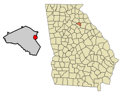
Clarke County is located in the northeastern part of the U.S. state of Georgia. As of the 2020 census, the population was 128,671. Its county seat is Athens, with which it is a consolidated city-county.
Gillsville is a city in Banks and Hall counties in the U.S. state of Georgia. The population was 235 at the 2010 census.
Lula is a city in Hall and Banks counties in the U.S. state of Georgia. Most of the city is in Hall County, with a small eastern portion of the city located in Banks County. The population was 2,822 at the 2020 census. The Hall County portion of Lula is part of the Gainesville, GA Metropolitan Statistical Area. Lula is the home of RailRoad Days, a yearly festival held usually every May. Lula is the railroad junction between the Atlanta northeast line and the Athens north line of Norfolk Southern Railway.
Maysville is a town in Banks and Jackson counties in the U.S. state of Georgia. The population was 1,798 at the 2010 census, up from 1,247 at the 2000 census.
Auburn is a city in Barrow and Gwinnett counties in the U.S. state of Georgia. As of the 2020 census, the city had a population of 7,495.
Statham is a city in Barrow County, Georgia, United States. The population was 2,408 at the 2010 census.
Bogart is a town in Clarke and Oconee counties in the U.S. state of Georgia. The town is mostly in Oconee County, with a portion extending into Clarke County. As of the 2020 census, the city had a population of 1,326. The 30622 ZIP code extends outside the boundary of Bogart into the western portion of Athens, giving some of Athens' citizens Bogart mailing addresses. For the Oconee County area of Bogart, the high school is North Oconee High School and the middle school is Malcom Bridge Middle School; for the Clarke County area of Bogart, the high school is Clarke Central High School and the middle school is Burney-Harris-Lyons Middle School.
Bowman is a city in Elbert County, Georgia, United States. As of the 2020 census, the city had a population of 872.
Franklin Springs is a city in Franklin County, Georgia, United States. The population was 952 at the 2010 census, up from 762 in 2000. Emmanuel University is located here.
Union City is a city in Fulton County, Georgia, United States. The population was 26,830 at the 2020 census.
Sparta is a city in and the county seat of Hancock County, Georgia, United States. It is part of the Milledgeville Micropolitan Statistical Area. The city's population was 1,400 at the 2010 census.
Nicholson is a city in Jackson County, Georgia, United States. The population was 1,696 at the 2010 census, up from 1,247 at the 2000 census.
Stapleton is a city in Jefferson County, Georgia, United States. The population was 438 at the 2010 census, up from 318 at the 2000 census.
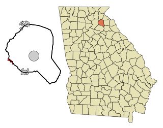
Arnoldsville is a city in Oglethorpe County, Georgia, United States. As of the 2020 census, the city had a population of 431.
Norwood is a city in Warren County, Georgia, United States. The population was 299 at the 2000 census.
Gordon is a city in Wilkinson County, Georgia, United States. As of the 2010 census, the town's population was 2,017.
Winterville Plantation is a plantation in Aroostook County, Maine, United States. The population was 194 at the 2020 census.
Winterville is a town in Pitt County, North Carolina, United States. The population was 10,591 as of the 2020 census. The town is a part of the Greenville Metropolitan Area.
There was a rumor floating around in the '80s that the Surfers had moved to Athens, Georgia for a very specific reason. It was Winterville, but yeah we lived in Georgia.