Wolayita has 358 kilometres (222mi) of all-weather roads and 425 kilometres (264mi) of dry-weather roads, for an average road density of 187 kilometres per 1000 square kilometres.[4] Its highest point is Mount Damota (2738 meters).
History
Before 1894
The people of Wolayta are known for their more than fifty kings within four dynasties.[5] The kings of Wolaita got the title Kawo. The Wolayta nationality are a proud people who had a distinct, continuous, strong and independent kingdoms going back to the 13th Century and beyond to the first Millennium until 1894. The war of resistance led by the last Kawo (King) of Wolaita, Tona Gaga, was one of the bloodiest campaigns in Menelik's whole period of expansion, which resulted in the incorporation of the Wolaita Kingdom, along with other nationalities and peoples in the South, into the Ethiopian Empire. The Wolaita's military resistance, and repulsion of Menelik’s generals (which were armed with modern firearms), showed the strength of Wolaita's military organization and people. The Wolaita’s resistance was finally crushed, with it conquered by Ethiopia, in 1894 after the bloodiest battle led by Emperor Menelik II himself.[6]
From 1894
Despite the centuries-old oppression, the Wolayta people have a distinct national identity, that is, the people have a language, culture, traditions, history, a psychological make-up, and a contiguous geography that define them and make them distinct from other nationalities and people in Ethiopia. The Wolayta people’s resistance and struggle against the Monarchical regime for economic and political emancipation, and the anti-democratic denial of the Wolayta peoples self-governance afterwards epitomizes their enduring and uninterrupted struggle for self-determination.[7]
Quest for statehood
During the 1991-94 Transitional Government period, the Wolayta had its own Region which was Kilil 9 but it was merged into the Southern Nations, Nationalities, and Peoples' Region (SNNPR) when the federation was constituted in 1995. Since, there has been public discontent and opposition members requesting autonomy were beaten, tortured, and a significant number of youths exiled.[8]
In 1997, SEPDM tried to create WOGAGODA, merging the neighboring ethnicities with Wolayta, which ultimately would have diluted the century-old culture and emblem of the Wolayta people. That attempt saw a fierce struggle from the people and the government’s homogenizing move was finally abandoned. However, thousands were detained and hundreds were killed, and hundreds of thousands of ethnic Wolaita were forcefully displaced from Arba Minch, the then capital of North Omo Zone, which dissolved after Wolaita, Gamo Gofa and Dawro split and formed their own zonal administration between 1998 and 2000. In popular mob security forces killed at least five when the Wolayta successfully campaigned for their own zone and rejected the attempted imposition of the new composite language and identity.[9]
Until 2000 Wolayita was part of the North Omo Zone, and the 1994 national census counted its inhabitants as part of that zone. However friction between the various ethnic groups in North Omo, which was often blamed on the Wolayta for "ethnic chauvinism" and despite the efforts of the ruling party to emphasize the need to co-ordinate, consolidate, and unify the smaller ethnic units to achieve the "efficient use of scarce government resources", eventually led to the division of the zone in 2000, resulting in the creation of not only the Wolayita, but also the Gamo Gofa and Dawro Zones, and two special woredas.[10]
The constitutional rights of the Wolayta people for statehood has gathered momentum in the recent years, where following widespread consultation held at all levels the proposal to establish a Wolaita Regional State was approved. During the administration of Dagato Kumbe, the Zonal Council unanimously voted to demand statehood, and consistent with the letter and spirit of the Constitution sent a formal letter on 19 December 2018 to the SNNPR Government requesting a referendum.[9]
In August 2020 38 members of SNNPR Council who represent the Wolaita zone withdrew themselves from the region's council in protests against move to reorganize the region into 4 states. Wolaita zone representatives say the move didn't consider their request for separate statehood.[11]
In May and December 2019 rallies were held in Wolaita supporting the separation of the zone from the SNNPR to become a region in its own right. A rally on 20 December 2019, oppose the failure of the regional council to send a request of the zone to become a regional state to the National Board of Election to arrange a referendum.[12]
2023 Referendum
In 2018 Wolayita have submitted a request to the SNNPR council to form their own new state. However, following the formation of Sidama regional state in June 2020, the request was not immediately dealt with. Instead the then ruling party SEPDM wanted to establish cluster regions by uniting two or more zones and special woredas. Originally, Wolayta zonal council insisted on a separate referendum and threatened a unilateral declaration of statehood. This led to a crackdown by federal security forces against the Wolayta zone leaders and activists that resulted in the arrest of several people.[13]
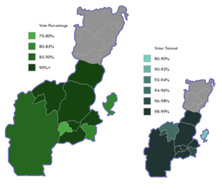
On 1 August 2022 after several months passed, the Wolayita zonal council gave in by reversing its decision and agreed to join the other zones and special woredas to form one state. As result, in February, referendum was held in Wolayta and other five zones and five special woredas in the Southern Nations, Nationalities and Peoples Regional State on statehood to determine whether Wolayta, Gamo, Gofa, South Omo, Gedeo and Konso zones and Dirashe, Amaro, Burji, Basketo and Ale special woredas will form a separate autonomous state or remain within the SNNPR.[14]
On 20 February, the National Election Board of Ethiopia released the results of referendum. However the official results from the Wolayita Zone were not announced at the moment.[15] As the board stated the case was a variety of irregularities occurred before and during the vote. These irregularities are due to the strict move for Wolayita to form their own regional state. As result, Wolayita Zone referendum was rerun on 19 June 2023. The referendum held for second time is different from other referendums held in Ethiopia as its voter registration and voting was held in one day.[16] After eight days later, the result was released and made Wolaita Zone as the part of South Ethiopia Regional State.
Geography
Omo river, Gibe III Dam in Wolayita
Wolayta is one of the 16 Zonal Administrations of the Southern Region In Ethiopia, located about 300 kilometers (190mi) south of Addis Ababa. Wolayta is limited north west by Tambaro, eastward by Bilate river which divides it from Arsi-Oromo, Southward by Lake Abaya and Kucha, westward by Omo River. Gilgel Gibe III Dam is a hydroelectric power plant built on Omo river; and with the capacity of 1870 Megawatt, it is the third largest hydroelectric plant in Africa.
The vegetation and climate of the large part of the region are conditioned by an overall elevation of between 1,500 and 1,800 meters (5,900ft) above the sea level. There are, however, five mountains higher than 2,000 meters (6,600ft), with Mount Damota — at 3,000 meters — at the center.
Damot Weyide
Through undulating hills there are no large forests except in the Sodo Zuria, and Omo river basin, which is below 1,500 meters (4,900ft) and a malaria zone.
In the local view, there are only two regions: the highlands Gezziya and the lowlands Garaa. In the highlands, there are streams and small rivers. Several thermal hot springs are situated around Lake Abaya, with boiling and steaming water.
The soil of the Wolayta is of heavy red color which becomes brown and black during the rains and has the fragility and the softness of sand. The dry period makes the soil hard as brick, making ploughing and digging possible after the rains. The layer of soil is very deep—an average of 30 meters—in both the plains and the hills, as verified during the drilling of wells. The soil is fertile and produce two crops per year when the rains are regular.
Climate
Wolaita's climate has a bimodal rainfall pattern that lasts from March to October. The first rainy season lasts from March to May. The season lasts from July to October, with a peak in July and August. Over the last 43 years, the average annual rainfall has been 1,014mm (39.9in). The average yearly temperature is 19.9°C, with monthly temperatures ranging from 17.7°C in July to 22.1°C in February and March.[17]
The climate is stable, with temperature variation between 24 and 30°C during the day and 16 to 20°C at night, all year round.[18] The year is divided into two seasons: the wet season (balgguwaa) from June to October, and the dry season (boniya) from October to June, broken in February by a short period of so-called "little rains" (badhdheesaa). The average rainfall for the entire region is 1,350 millimetres (53in) per year.[19]
The dry season is characterized by a strong wind which blows from the east. During the wet seasons, heavy precipitation and violent storms which, at the end of the season can last a full evening or night are common events. Fog can be seen in the valleys almost every morning of the rainy season; it then evaporates in the first hours of the sun. In both dry and wet seasons either hail which destroys crops or tornadoes, which knock down trees, are possible events.
Demographics
Based on the 2021 population projection conducted by the Central Statistical Agency of Ethiopia (CSA), the zone has a total population of 6,142,063 (in an area of 4,208.64 square kilometres (1,624.96sqmi)).[2] Out of the total population of the zone, females count 3,115,050 and males count 3,027,013. Wolayita has a population density of 520.8 per square kilometer.[20]
The 2007 Census conducted by the CSA reported a total population for this Zone of 1,501,112. While 366,567 or 11.49% were urban inhabitants, a further 1,196 or 0.08% were pluralists. A total of 310,454 households were counted in the zone, which resulted in an average of 4.84 persons to a household, and 297,981 housing units. The largest ethnic group reported in the zone was the Wolayta (96.31%); all other ethnic groups made up 3.69% of the population. Welayta was spoken as a first language by 96.82% of the inhabitants; the remaining 3.18% spoke all other primary languages reported. 51.34% were Protestants, 43.04% of the population said they practiced Ethiopian Orthodox Christianity, and 5.35% embraced Catholicism.[21]
Wolaita Zone is composed of sixteen woredas and seven city administrations. There are also different towns and cities in the Wolaita zone. Sodo town is administrative and trading center it is located at the center of roads to and seven entering gates. The followings are urban centres in the Wolaita Zone.
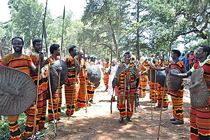
Gifaataa is the most well-known festival among those rituals in Wolaita that has been celebrated annually in the month of September. The festival of New Year in Wolaita called Gifaataa, is celebrated eating the special foods Baacciraa and Muchchuwaa on the eve and throughout the celebration weeks. Gifaataa is Wolaita's New year festival-which Wolaitas had been celebrating many hundred years ago. Gifaataa celebrated in always Sunday in each Year, which falls between Meskerem (September) 14 and 20.[22] Gifaataa is a bridge that brings together all from near and far.[23]
Wolaita war dance
Tourism
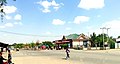
Tourists coming into Wolaita Sodo enter the city from Addis Ababa by traveling overland through the Butajira about 310km (190mi) or Shashemane roads about 380km (240mi). Alternatively, tourists may take the local bus transportation from Addis Ababa to Wolaita or travel by air, flying into Arba Minch and taking land transportation from Arba Minch to Wolaita Sodo. The city has a bus terminal and an airport. However, the latter is not fully functional and does not accept commercial flights.[24]
Leke Playing
There are different potential tourist sites, that were selected in the Wolaita Zone to assess the region's ability to capture the natural heritage and cultural heritage tourist markets.[25]
The Ajora Falls are twin waterfalls formed by the Ajancho and Skokie rivers located approximately 390km (240mi) from Addis Ababa. The Ajancho waterfall drops 210 meters (690ft) from the edge of the cliff while the Soke is slightly less at 170 meters (560ft). The 118 falls are located 7km (4.3mi) north of the town of Areka, but access to the site requires driving roughly 25km (16mi) along a dirt from the town. As with many tourist sites throughout Ethiopia, tourism at Ajora Falls is dominated by domestic tourists, sometimes exceeding foreign tourists by 23 times. Annually the site averages 14 international and 195 domestic tourists.[26]
Mochena Borago
The Mochena Borago Rockshelter is located northwest of the city of Wolaita Sodo, on the southwestern slope of Mt. Damota. Damota also known as Mount Damot rises over 2,900m (9,500ft) above sea level although the Mochena Borago Rockshelter lies at around 2,200m (7,200ft) above sea level. In order to access the Mochena Borago Rockshelter, tourists drive approximately, 10km (6.2mi) from Wolaita Sodo along the Hosanna road. A sign marks the turnoff for the unpaved road leading to the rockshelter. Over the years, access to the site has become easier. A small trickling waterfall runs off the top of the rockshelter into a stream that runs to the base of the mountain. From 2006 to 2008 the University of Florida’s Southwest Ethiopia Archaeological Project (SWEAP) concentrated upon excavating the shelter’s late Pleistocene deposits.[27]
Natural Bridge
Natural bridge is found in Wolaita Zoneoffa woreda at a distance of 5 k.m from wereda town Gesuba and 29 k.m from zonal administrative town, Sodo. The bridge which was made naturally from one big stone lying over the flowing river Manisa. The name of this bridge called (ye egzier dildiy) in Amharic
Abala Chokare (Bilbo Hotspring)
The hot spring is situated in Humbo Woreda Abela mareka kebele. The circle shaped hot spring covers wide areas and has rising smoke and boiled bubbles coming from within the ground and the water vapor can be seen from a distance.[28]
Mount Damota
Damota mountain is found in wolaita zone Sodo Zuria woreda about 12 k.m away from the town of Sodo to the North, and is nearly 3000 meter above sea level.
Sports
Wolayta Dicha fans
There are different clubs in Wolaita that compete in various sporting activities at a national and continental level. Wolaitta Dicha S.C. is an Ethiopian football club based in Sodo. The club was established in 2009 by the Welayta Development Association. Wolaitta Dicha is a name that now common with East African nationals and even the entire Africa. The club from Southern Ethiopia eliminated Egyptian giants and five times winners of the CAF Champions league Zamalek in a dramatic penalty shootout in Cairo. The club replaced the Wolaita Tussa S.C. before the so-called tussa restructured and came into picture newly. The club got its nickname "Bees of Tona" from the Wolaita Kingdom leader "King Tona" in the 19th century. Wolaitta Dicha S.C. club won its first domestic cup in 2017, and qualified for the 2018 CAF Confederation Cup, in which the club beat Zamalek SC and passed to the quarter-final.
Wolaita Sodo City sport Club is also another which is based in the city of Wolaita Sodo. It was officially established in 2011. The club is participating in Ethiopian First League.
Boditi City F.C. is Ethiopian football club based on the city of Boditi. In 2021 the Club represented Wolayita Zone in the Southern Nations, Nationalities, and Peoples' Region (SNNPR) regional Championship in Jinka, ended its season with a victory.[29]
Wolaita Dicha Men's volleyball team was established in January 2005 E.C. Wolaita Dicha Volleyball Team is sport team based in Wolaita Sodo. The team won Ethiopia volleyball premier league for several times. And as well as represented Ethiopia in the African volleyball club championship of 2019 and 2021.[30]
The Wolaita Zone Administration has made great strides in the social, economic and political spheres over the years in its efforts to achieve rapid and sustainable economic growth by developing a long-term and medium-term plan to alleviate poverty and backwardness and improve the public's access to various media resources. The mass media in wolaita consist of radio, television and the Internet, which remain under the control of the Ethiopian government, as well as private newspapers and magazines. The radio broadcasting stations in Sodo include Radio wogeta 96.6 and Radio fana 99.9. Satellite television has been very popular in Ethiopia for many years. In addition to this, Wolaita Tv which made Wolaita Zone accessible to the cultural and historical information of the people of the zone by investing heavily in various media outlets due to the lack of television media in the area.[31]
Education is a key to ensuring the sustainable socio-economic and political development of a country. Wolaita Zone, in Ethiopia's South Ethiopia Regional State, is a rural and thickly inhabited area. The educational system is struggling to provide excellent instruction and assistance, and secondary schools are in limited supply. To this end to improve education system in the Zone, Zonal education department working with Scotland’s leading international education charity. This organization working to improve education across sub-Saharan Africa and beyond.[32] In Wolaita, there are schools that are among the oldest in Ethiopia; for instance, the Dubbo Our Lady’s Catholic School and Ligaba Aba-Sebsib school, which were established in 1933 and 1945, respectively. Wolaita Sodo University (WSU), established in 2007, is a public higher education institution located in Sodo. The university has been engaged in teaching/learning, research and community services. The university has campuses in different areas, such as in Gandaba, Otona and Dawuro Tarcha Campuses.
There are different government and private colleges are opened in Wolaita Zone. Wolayta sodo Agricultural College This college was established in 2001. It is technical and vocational training centre established in Wolaita Sodo city. In addition to these, Sodo city schools include Wolaita Sodo Secondary & preparatory school, Wolaita Liqa School and also Bogale Walelu Secondary and Preparatory School.
Agriculture is the livelihood for more than 90% of the population in the rural areas. Animal husbandry is complementary to crop production, and the livestock population of Wolayita with estimated standing populations of 685,886 cattle, 87,525 sheep, 90,215 goats, 1951 horses, 669,822 poultry and 38,564 bee hives.[35] Farmers are well known for the production of livestock, predominantly cattle for their organic beef and butter (Million, 2003). They have long tradition of fattening oxen distinctively practiced using local/home based feed supplement/concentrate (cereal grains, root and tuber crops), household leftovers, grass)(Takele and Habtamu, 2009). The Sodo milkshed is also one of the areas with a strong potential to achieve growth in milk production. Maize, haricot bean, taro, sweet potato, enset, banana, avocado, mango and coffee are the major crops with tremendous benefits to smallholder farmers’ in Wolaita and surrounding areas (CSA, 2020). Cassava is also flourishing nowadays. Mixed farming involving the production of cereals, root crops, Enset, and coffee are practiced. Enset is an essential element in Wolayita food economy and acts as a staple, or co-staple, food. Where land is very scarce and consequently where cereal harvests are low, high yielding Enset offers some opportunity for food security. Enset is also popular because of its drought resistant properties.[36]
Administrative divisions
Duguna Pango biittaa utettaaDiguna Fango
Woredas and City administrations in Wolaita Zone[37]
• City administrations, which are considered as Woreda for all administrative purposes.
Fauna and Flora
In the Wolaita, the spread of animal species is also diverse. Middle-order mammals predominate, with a small population of herbivores and a small number of peripheral species.[38] Throughout the year, eucalyptus, pines, acacia, magnolias, fire trees, and giant sycamores coexist alongside fake banana trees (Uuttaa). Grass may reach three meters in height towards the conclusion of the wet season. The communities are surrounded by enormous fields of grain and, above all, large cotton plantations, which serve as indicators of their wealth. Here is the cotton land, where Ethiopian mantles are manufactured, where this plant thrives, which, together with coffee, is the source of Ethiopia's current wealth and will become the country's major export commodity in the near future. Maize, wheat, durra, barley, and teff are all grown in the area. Many of them may be harvested twice a year. All Mediterranean trees produce fruit throughout the year: grapes, apples, pears, peaches, apricots, oranges, tangerines, bananas, papayas, avocados, and so on.
Notable persons
Asrat Tera (PhD), is an Ethiopian politician serving as Director General of Livestock Development Institute of Ethiopia since October 2018
Chernet Gugesa, an Ethiopian professional who plays for Ethiopian Premier League club Saint George and the Ethiopia national team
Dagato Kumbe, former chief adiminstrator of Wolayita Zone and Director General of FDRE Documents Registration and Authentication Service
Endrias Geta, is an Ethiopian politician serving as State Minister of Ministry of Irrigation and Lowland and Areas
Firew Altaye, Ethiopian politician and second chief administrator of Wolayita Zone
Gebremeskel Chala (PhD), current Minister of the Ethiopian Trade and Regional Integration
Kawo Ogato Sana, was one of the most renowned kings of the Kingdom of Wolaita along with Tigre dynasty.
Kawo Tona Gaga, the last king of Kingdom of Wolaita. Believed to be one of the greatest warriors and the most powerful king of Wolayta. His army defeated King Menelik's forces six times before losing to combined forces of Menelik and Abba Jifar in 1896.
Roman Tesfaye, First Lady of Ethiopia (2012–2018). In the past, she held senior management positions in the United Nations Development Program and other offices[39]
Yeshurun Alemayehu, (PhD), is Deputy Director General of Ethiopian Space Science & Technology Institute, Team Leader of the First Ethiopian Satellite Development Team
Related Research Articles
The Southern Nations, Nationalities, and Peoples' Region was a regional state in southwestern Ethiopia. It was formed from the merger of five kililoch, called Regions 7 to 11, following the regional council elections on 21 June 1992. Its government was based in Hawassa.
Sodo or officially Wolaita Sodo is a city in south Ethiopia. The City is a political and administrative center of the Wolaita Zone and South Ethiopia Regional State. It has a latitude and longitude of 6°54′N37°45′E with an elevation between 1,600 and 2,100 metres above sea level. It was part of the former Sodo woreda which included Sodo Zuria which completely surrounds it.
North Omo Zone was a zone in the Southern Nations, Nationalities, and Peoples' Region of Ethiopia. It was named after the Omo River, which flows in the western area of the former zone. In 2000 it was split into three zones: Dawro, Gamo Gofa, and Wolayita; and Basketo and Konta became special woredas.
The Welayta, Wolayta or Wolaytto are an ethnic group and its former kingdom, located in southern Ethiopia. According to the most recent estimate (2017), the people of Wolayta numbered 5.83 million in Welayta Zone. The language of the Wolayta people, similarly called Wolaytta, belongs to the Omotic branch of the Afro-Asiatic language family. Despite their small population, Wolayta people have widely influenced national music, dance and cuisine in Ethiopia.
Wolayta, Wolayita or Wolaita may refer to:
Dawro is a zone in the Southwest Region of Ethiopia. The name "Dawuro" represents both the land and the people. It is located at about 500km southwest of Addis Ababa, the capital of Ethiopia, about 111 km west of Wolaita Sodo, the capital of South Ethiopia Regional State and 319 km of Hawassa the capital of the Sidama Region. Dawuro is bordered on the south by Gofa Zone, on the west by the Konta Zone, on the north by the Gojeb River which defines its boundary with the Oromia Region,Jimma zone, on the northeast by Hadiya and Tembaro Special Woreda in Central Ethiopia Regional State, and on the east by Wolayita Zone; the Omo River defines its eastern and southern boundaries.
Wolaitta Dicha Sport Club is a professional football club based in Sodo, Ethiopia. They play in the Ethiopian Premier League, the top division of Ethiopian football.
Mount Damota or Mount Damot is the highest peak in Wolayita, Southern Nations, Nationalities, and Peoples' Region, Ethiopia with altitude of nearly 2,750 meters (9,020 ft) above the sea level. Mt. Damota area is found in Wolaita Zone between Damot Gale, Boloso Sore, and Soddo Zuria districts. Mt. Damota is a source of many streams flowing to different districts in radial pattern namely: Hamessa, Waja (river), Bisare, Gazina and other rivers.
Tebela or (Wolaita: Xabala) is a city in Wolaita Zone South Ethiopia Regional State. Tebela is an administrative capital of Humbo woreda district of Wolayita Zone. Tebela is located about 345 km away from Addis Ababa to the south. And also, Tebela is located 20 km, South from Sodo, the capital of the region and also Wolayita Zone. The coordinate point of the town in map is 6°42′24″N 37°46′10″E. The amenities in the town are; 24 hours electricity, pure public water, banks, primary and secondary schools, postal service, telecommunications services health centre, private clinics, drugs store, public market, public road light around high ways, internal and town crossing asphalt roads and others.
Kercheche or is a town in Diguna Fango woreda, Wolayita Zone of South Ethiopia Regional State. Kercheche is about 10 km (6.2 mi) north of Bedessa and about 8 km (5.0 mi) southwest of Bitena on the road of Sodo-Dimtu Hawassa. The approximate distance from the city of Addis Ababa to the town is 362 km (225 mi) on Addis-Hawassa-Dimtu-Sodo road. It is 38 km (24 mi) from Sodo, the capital of Wolayita Zone. The coordinate point of Kercheche lies between 6°57'21"N 37°59'29"E. The amenities in the town are 24-hours electric light, pure water service, kindergarten, primary school, high school, all time market, health stations and others. Kercheche has also dry weather and all weather roads which connect it to other surrounding areas.
Bayra Koysha is the woredas in Wolayita Zone of the South Ethiopia Regional State in Ethiopia. Bayra Koysha was established in 2019 from the other surrounding woredas. Bayra Koysha is bordered by Sodo Zuria on east, Damot Sore on north, Kawo Koysha on west and on south Humbo woredas. The administrative town of this woreda is Beklo Segno.
Bombe is a town in Wolayita Zone of the South Ethiopia Regional State, Ethiopia. Bombe town is located 325 km and 55 km away from Addis Ababa and Wolaita Sodo town through Hossana exit, respectively. Bombe town is used as an administrative capital of Boloso Bombe woreda of Wolaita Zone. It is located at an elevation of 1,531 meters above sea level. The amenities in the town are 24 hours electric light, pure water service, kindergarten, primary and high schools, health center, everyday public market and others. Bombe lies between about 7°08'04"North 37°34'54"East
Kingdom of Wolaita, also known as Wolaita Kingdom, was a kingdom dominated by Wolayta people in today's southern Ethiopia from 1251 until conquest of Ethiopian Empire in 1896.
Lasho is a town in Wolayita Zone of the South Ethiopia Regional State, Ethiopia. The approximate distance from the town of Sodo to Lasho is about 79 kilometres to Northwest via B52. And also the distance from Addis Ababa to Bombe is 388 km via Butajira-Worabe-Sodo to Southwest. Lasho town is used as an administrative capital of Kawo Koysha woreda of Wolaita Zone. It is located at an elevation of 2,130 meters above sea level. Lasho is a populated place in South Ethiopia Regional State. The amenities in the town are 24 hours electric light, pure water service, kindergarten, primary and high schools, health center, everyday public market and others. Lasho lies between about 6°42'29" North 37°28'23" East
Boditi Stadium or Boditi City Stadium is a stadium in Southern Ethiopia within Wolayita Zone. The stadium is multipurpose stadium based in Boditi city, Northeastern part of Wolayita Zone. It is primarily used for concerts and also serves as Boditi City F.C.'s home stadium. And it used by Wolaita Dicha sport club for matches of Ethiopian Premier League as home stadium when Sodo Stadium is under renewal and enlargement in 2007 and 2008 Ethiopian calendar. The full capacity for seated spectators enjoying a football match at Boditi Stadium is about 1,500. The stadium geographical location lies on the 6°57'19" N and 37°51'37" E. And also elevation of the stadium is 2038 meters above the sea level.
Dalbo is a town in Southern Nations, Nationalities, and Peoples' Region, Ethiopia within Wolayita Zone. Dalbo is located about 304 km away from Addis Ababa to the south through Butajira. And the town is located 11 km, North from Sodo, the capital of Wolayita Zone. The coordinate point of the town in map is 6°54′0″N 37°52′0″E with elevation of 2349 meters above the sea level.
Firew Altaye Gebremedhin or ፍሬው አልታዬ ገብረመድህን was born on 2 August 1966. He was an Ethiopian politician and second chief administrator of Wolayita Zone, from 2002 to 2004 and he was succeeded by Amanuel Otoro. He served as member of Ethiopian parliament from 2001 to 2002.
On 6 February 2023 a referendum was held in the Wolayita, Gamo, Gofa, South Omo, Gedeo, and Konso Zones, as well as the Dirashe, Amaro, Burji, Ale, and Basketo special woredas of the Southern Nations, Nationalities, and Peoples' Region (SNNP) of Ethiopia, on whether the included areas should leave SNNP and form their own Region.
Wamura is a town in Wolayita Zone of the South Ethiopia Regional State of Ethiopia. The town is found in western part of Kawo Koysha woreda. Wamura is one of municipal administrations in Kawo Koysha woreda. The town has different infrastructures and governmental service centers such as electricity, pure public water, primary and high schools, postal service, telecommunications services, health care institutions and others. Wamura is located in the West of Wolaita Sodo via Sodo-Beklo Segno-Lasho road on the way to Halale.
Endrias Geta Baldada is an Ethiopian politician serving as State Minister of Ministry of Irrigation and Lowland and Areas. Endrias is from the Wolaita people and he served as chief administrator of Wolayita Zone after SNNPR Prosperity Party ousted Dagato Kumbe from his position in August 2020.
↑ Sarah Vaughan (2003). "Ethnicity and Power in Ethiopia"(PDF). www.ihasa.org. University of Edinburgh: Ph.D. Thesis. pp.251–260. Archived from the original(PDF) on 2021-02-25. Retrieved 2021-11-13.
This page is based on this Wikipedia article Text is available under the CC BY-SA 4.0 license; additional terms may apply. Images, videos and audio are available under their respective licenses.