Woodston, Kansas

Last updated

Woodston, Kansas
Woodston Kansas City Office est 1910.jpg
Woodston City Office est 1910 (2016)
Rooks County Kansas Incorporated and Unincorporated areas Woodston Highlighted.svg
Location within Rooks County and Kansas
Map of Rooks Co, Ks, USA.png
Coordinates: 39°27′14″N99°05′54″W / 39.45389°N 99.09833°W / 39.45389; -99.09833 [1]
Country United States
State Kansas
County Rooks
Founded1885
Incorporated 1905
Named for Charles Woods
Area
[2]
  Total0.21 sq mi (0.55 km2)
  Land0.21 sq mi (0.55 km2)
  Water0.00 sq mi (0.00 km2)
Elevation
[1]
1,709 ft (521 m)
Population
 (2020) [3]
  Total94
  Density450/sq mi (170/km2)
Time zone UTC-6 (CST)
  Summer (DST) UTC-5 (CDT)
ZIP code
67675
Area code 785
FIPS code 20-80450
GNIS ID 2397374 [1]

Woodston is a city in Rooks County, Kansas, United States. [1] As of the 2020 census, the population of the city was 94. [3]

Contents

History

Woodston was established along the Missouri Pacific Railroad in 1885 as a railroad town between Bull City (Alton) and Stockton. Woodston was named for Stockton businessman Charles C. Woods who was instrumental in getting railroad service to Stockton. [4]

The Rooks Centre Post Office, established in 1872, was moved to Woodston in 1886. [5]

Woodston filed for incorporation in 1905. [6]

Geography

According to the United States Census Bureau, the city has a total area of 0.24 square miles (0.62 km2), all of it land. [7]

Demographics

Historical population
CensusPop.Note
1910 299
1920 3145.0%
1930 287−8.6%
1940 286−0.3%
1950 2963.5%
1960 33212.2%
1970 211−36.4%
1980 157−25.6%
1990 121−22.9%
2000 116−4.1%
2010 13617.2%
2020 94−30.9%
U.S. Decennial Census

2010 census

As of the census [8] of 2010, there were 136 people, 53 households, and 38 families living in the city. The population density was 566.7 inhabitants per square mile (218.8/km2). There were 82 housing units at an average density of 341.7 per square mile (131.9/km2). The racial makeup of the city was 94.9% White, 1.5% African American, 2.9% Asian, and 0.7% from two or more races. Hispanic or Latino of any race were 0.7% of the population.

There were 53 households, of which 34.0% had children under the age of 18 living with them, 50.9% were married couples living together, 11.3% had a female householder with no husband present, 9.4% had a male householder with no wife present, and 28.3% were non-families. 24.5% of all households were made up of individuals, and 9.5% had someone living alone who was 65 years of age or older. The average household size was 2.57 and the average family size was 2.92.

The median age in the city was 34.5 years. 26.5% of residents were under the age of 18; 11% were between the ages of 18 and 24; 20.6% were from 25 to 44; 24.3% were from 45 to 64; and 17.6% were 65 years of age or older. The gender makeup of the city was 54.4% male and 45.6% female.

2000 census

As of the census [9] of 2000, there were 116 people, 63 households, and 22 families living in the city. The population density was 489.7 inhabitants per square mile (189.1/km2). There were 87 housing units at an average density of 367.3 per square mile (141.8/km2). The racial makeup of the city was 98.28% White and 1.72% Native American. Hispanic or Latino of any race were 0.86% of the population.

There were 63 households, out of which 17.5% had children under the age of 18 living with them, 31.7% were married couples living together, 3.2% had a female householder with no husband present, and 63.5% were non-families. 57.1% of all households were made up of individuals, and 31.7% had someone living alone who was 65 years of age or older. The average household size was 1.84 and the average family size was 3.09.

In the city, the population was spread out, with 23.3% under the age of 18, 2.6% from 18 to 24, 24.1% from 25 to 44, 21.6% from 45 to 64, and 28.4% who were 65 years of age or older. The median age was 45 years. For every 100 females, there were 107.1 males. For every 100 females age 18 and over, there were 107.0 males.

The median income for a household in the city was $20,357, and the median income for a family was $25,625. Males had a median income of $23,438 versus $13,750 for females. The per capita income for the city was $10,592. There were 11.1% of families and 23.5% of the population living below the poverty line, including 28.6% of under eighteens and none of those over 64.

Education

Woodston is part of Unified School District 271. [10] The district doesn't have any schools in Woodston.

Woodston High School closed in 1968. The grade school closed in 1974. [6] The Woodston High School mascot was Woodston Coyotes. [11]

Related Research Articles

<span class="mw-page-title-main">Rooks County, Kansas</span> County in Kansas, United States

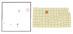
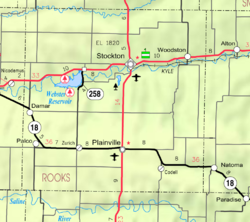
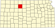
Rooks County is a county located in the U.S. state of Kansas. Its county seat is Stockton, and its largest city is Plainville. As of the 2020 census, the county population was 4,919. The county was named for John Rooks, a private in Company I of the 11th Kansas Cavalry Regiment, who died at the Battle of Prairie Grove during the American Civil War.

<span class="mw-page-title-main">Stockton, Iowa</span> City in Iowa, United States

Stockton is a city in Muscatine County, Iowa, United States. The population was 176 at the time of the 2020 census. It is part of the Muscatine Micropolitan Statistical Area.

<span class="mw-page-title-main">Morrill, Kansas</span> City in Brown County, Kansas

Morrill is a city in Brown County, Kansas, United States. As of the 2020 census, the population of the city was 218.

<span class="mw-page-title-main">Coldwater, Kansas</span> City in Comanche County, Kansas

Coldwater is a city and county seat of Comanche County, Kansas, United States. As of the 2020 census, the population of the city was 687.

<span class="mw-page-title-main">Carlton, Kansas</span> City in Dickinson County, Kansas

Carlton is a city in Dickinson County, Kansas, United States. As of the 2020 census, the population of the city was 40.

<span class="mw-page-title-main">Manchester, Kansas</span> City in Dickinson County, Kansas

Manchester is a city in Dickinson County, Kansas, United States. As of the 2020 census, the population of the city was 47.

<span class="mw-page-title-main">Webber, Kansas</span> City in Jewell County, Kansas

Webber is a city in Jewell County, Kansas, United States. As of the 2020 census, the population of the city was 30.

<span class="mw-page-title-main">Bern, Kansas</span> City in Nemaha County, Kansas

Bern is a city in Nemaha County, Kansas, United States. As of the 2020 census, the population of the city was 161.

<span class="mw-page-title-main">Seneca, Kansas</span> City in Nemaha County, Kansas

Seneca is a city in and the county seat of Nemaha County, Kansas, United States. As of the 2020 census, the population of the city was 2,139.

<span class="mw-page-title-main">Olivet, Kansas</span> City in Osage County, Kansas

Olivet is a city in Osage County, Kansas, United States. As of the 2020 census, the population of the city was 73. It is located near the south side of Melvern Lake.

<span class="mw-page-title-main">St. George, Kansas</span> City in Pottawatomie County, Kansas

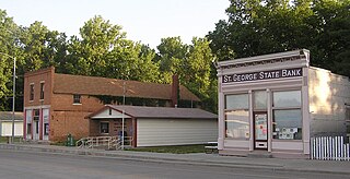
St. George or Saint George is a city in Pottawatomie County, Kansas, United States. As of the 2020 census, the population of the city was 1,054. The name might have been intended to honor several pioneer settlers named George.

<span class="mw-page-title-main">Stockton, Kansas</span> City in Rooks County, Kansas

Stockton is a city in and the county seat of Rooks County, Kansas, United States. As of the 2020 census, the population of the city was 1,480.

<span class="mw-page-title-main">Andale, Kansas</span> City in Sedgwick County, Kansas

Andale is a city in Sedgwick County, Kansas, United States. As of the 2020 census, the population of the city was 941.

<span class="mw-page-title-main">Kechi, Kansas</span> City in Sedgwick County, Kansas

Kechi is a city in Sedgwick County, Kansas, United States, and a suburb of Wichita. As of the 2020 census, the population of the city was 2,217.

<span class="mw-page-title-main">Mount Hope, Kansas</span> City in Sedgwick County, Kansas

Mount Hope is a city in Sedgwick County, Kansas, United States. As of the 2020 census, the population of the city was 806.

<span class="mw-page-title-main">Stockton, Missouri</span> City in Missouri, United States

Stockton is a city in Cedar County, Missouri, United States. The population was 1,683 at the 2020 census. It is the county seat of Cedar County.

<span class="mw-page-title-main">Randolph, Missouri</span> City in Missouri, United States

Randolph is a city in Clay County, Missouri, United States. The population was 57 at the 2020 census. It is completely surrounded by Kansas City and is a part of the Kansas City metropolitan area.

<span class="mw-page-title-main">Ferrelview, Missouri</span> Village in Missouri, United States

Ferrelview is a village in Platte County, Missouri in the United States. It is within the Kansas City metropolitan area. The population was 451 at the 2010 census.

<span class="mw-page-title-main">Oakwood Park, Missouri</span> Village in Missouri, United States

Oakwood Park is a village in Clay County, Missouri, United States. The population was 189 at the 2020 census. It is part of the Kansas City metropolitan area.

<span class="mw-page-title-main">Vining, Kansas</span> City in Clay and Washington Counties in Kansas

Vining is a city in Clay and Washington counties in Kansas, United States. As of the 2020 census, the population of the city was 43.

References

  1. 1 2 3 4 U.S. Geological Survey Geographic Names Information System: Woodston, Kansas
  2. "2019 U.S. Gazetteer Files". United States Census Bureau. Retrieved July 24, 2020.
  3. 1 2 "Profile of Woodston, Kansas in 2020". United States Census Bureau. Archived from the original on March 15, 2022. Retrieved March 15, 2022.
  4. "Origin of Town Names" (PDF). Solomon Valley Highway 24 Heritage Alliance. p. 4. Retrieved April 9, 2018.
  5. "Kansas Post Offices, 1828-1961". Kansas Historical Society. Retrieved December 21, 2016.
  6. 1 2 "History of Woodston" (PDF). Solomon Valley Highway 24 Heritage Foundation. Retrieved December 30, 2016.
  7. "US Gazetteer files 2010". United States Census Bureau . Retrieved July 6, 2012.
  8. "U.S. Census website". United States Census Bureau . Retrieved July 6, 2012.
  9. "U.S. Census website". United States Census Bureau . Retrieved January 31, 2008.
  10. "Stockton USD 271" . Retrieved January 3, 2017.
  11. "Woodston Wins P and R Title", The Salina Journal, 24 November 1958, p.14.

Further reading