Related Research Articles

The Reclamation Act of 1902 is a United States federal law that funded irrigation projects for the arid lands of 20 states in the American West.
The United States Bureau of Reclamation (USBR), and formerly the United States Reclamation Service, is a federal agency under the U.S. Department of the Interior, which oversees water resource management, specifically as it applies to the oversight and operation of the diversion, delivery, and storage projects that it has built throughout the western United States for irrigation, water supply, and attendant hydroelectric power generation. Currently the USBR is the largest wholesaler of water in the country, bringing water to more than 31 million people, and providing one in five Western farmers with irrigation water for 10 million acres of farmland, which produce 60% of the nation's vegetables and 25% of its fruits and nuts. The USBR is also the second largest producer of hydroelectric power in the western United States.
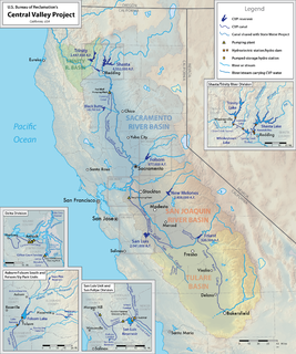
The Central Valley Project (CVP) is a federal power and water management project in the U.S. state of California under the supervision of the United States Bureau of Reclamation (USBR). It was devised in 1933 in order to provide irrigation and municipal water to much of California's Central Valley—by regulating and storing water in reservoirs in the northern half of the state, and transporting it to the water-poor San Joaquin Valley and its surroundings by means of a series of canals, aqueducts and pump plants, some shared with the California State Water Project (SWP). Many CVP water users are represented by the Central Valley Project Water Association.

The Sacramento–San Joaquin River Delta, or California Delta, is an expansive inland river delta and estuary in Northern California. The Delta is formed at the western edge of the Central Valley by the confluence of the Sacramento and San Joaquin rivers and lies just east of where the rivers enter Suisun Bay. The Delta is recognized for protection by the California Bays and Estuaries Policy. Sacramento–San Joaquin Delta was designated a National Heritage Area on March 12, 2019. The city of Stockton is located on the San Joaquin River on the eastern edge of the delta. The total area of the Delta, including both land and water, is about 1,100 square miles (2,800 km2). Its population is around 500,000 residents.

Shasta Dam is a concrete arch-gravity dam across the Sacramento River in Northern California in the United States. At 602 feet (183 m) high, it is the eighth-tallest dam in the United States. Located at the north end of the Sacramento Valley, Shasta Dam creates Shasta Lake for long-term water storage, flood control, hydroelectricity and protection against the intrusion of saline water. The largest reservoir in the state, Shasta Lake can hold about 4,500,000 acre feet (5,600 GL).

The Trinity River is a major river in northwestern California in the United States, and is the principal tributary of the Klamath River. The Trinity flows for 165 miles (266 km) through the Klamath Mountains and Coast Ranges, with a watershed area of nearly 3,000 square miles (7,800 km2) in Trinity and Humboldt Counties. Designated a National Wild and Scenic River, along most of its course the Trinity flows swiftly through tight canyons and mountain meadows.

New Melones Dam is an earth and rock filled embankment dam on the Stanislaus River, about 5 miles (8.0 km) west of Jamestown, California, United States, on the border of Calaveras County and Tuolumne County. The water impounded by the 625-foot (191 m)-tall dam forms New Melones Lake, California's fourth largest reservoir, in the foothills of the Sierra Nevada east of the San Joaquin Valley. The dam serves mainly for irrigation water supply, and also provides hydropower generation, flood control, and recreation benefits.

Friant Dam is a concrete gravity dam on the San Joaquin River in central California in the United States, on the boundary of Fresno and Madera Counties. It was built between 1937 and 1942 as part of a U.S. Bureau of Reclamation (USBR) water project to provide irrigation water to the southern San Joaquin Valley. The dam impounds Millerton Lake, a 4,900-acre (2,000 ha) reservoir about 15 miles (24 km) north of Fresno.

San Luis Dam is a major earth-filled dam in Merced County, California, which forms San Luis Reservoir, the largest off-stream reservoir in the United States. The dam and reservoir are located in the Diablo Range to the east of Pacheco Pass and about 10 miles (16 km) west of Los Banos. San Luis Dam, a jointly-owned state and federal facility, stores more than 2 million acre feet of water for the California State Water Project and the federal Central Valley Project. Although the dam is located in the valley of San Luis Creek, the majority of its water comes from man-made aqueducts which are supplied from other rivers in Northern California.

The Stanislaus River is a tributary of the San Joaquin River in north-central California in the United States. The main stem of the river is 96 miles (154 km) long, and measured to its furthest headwaters it is about 150 miles (240 km) long. Originating as three forks in the high Sierra Nevada, the river flows generally southwest through the agricultural San Joaquin Valley to join the San Joaquin south of Manteca, draining parts of five California counties. The Stanislaus is known for its swift rapids and scenic canyons in the upper reaches, and is heavily used for irrigation, hydroelectricity and domestic water supply.

Trinity Dam is an earthfill dam on the Trinity River located about 7 miles (11 km) northeast of Weaverville, California in the United States. The dam was completed in the early 1960s as part of the federal Central Valley Project to provide irrigation water to the arid San Joaquin Valley.
Westlands Water District is a water district in central California, i.e. a local-government entity formed in 1952 that holds long-term contracts for water supplied by the Central Valley Project and the California State Water Project.
The environment of California describes results of human habitation of the State of California.
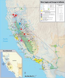
California's interconnected water system serves over 30 million people and irrigates over 5,680,000 acres (2,300,000 ha) of farmland. As the world's largest, most productive, and most controversial water system, it manages over 40 million acre feet (49 km3) of water per year.
The Consolidated Natural Resources Act of 2008 was an act passed in the 110th United States Congress and enacted on May 8, 2008.
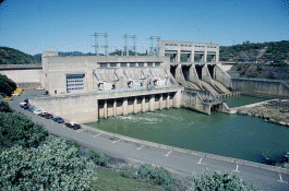
Keswick Dam is a concrete gravity dam on the Sacramento River about 2 miles (3.2 km) northwest of Redding, California. Part of the U.S. Bureau of Reclamation's Central Valley Project, the dam is 157 feet (48 m) high and impounds the Keswick Reservoir, which has a capacity of 23,800 acre⋅ft (29,400,000 m3). The dam's power plant has three turbines with a generating capacity of 117 megawatts (MW), which, in 1992, was uprated from its original 75 MW. The dam and reservoir serve as a forebay to regulate peaking power releases from the Shasta Dam upstream.

Lake Tahoe Dam is a concrete gravity dam on the Truckee River, at the outlet of Lake Tahoe in Placer County, California.

Red Bluff Diversion Dam is a disused irrigation diversion dam on the Sacramento River in Tehama County, California, United States, southeast of the city of Red Bluff. Until 2013, the dam provided irrigation water for two canals that serve 150,000 acres (61,000 ha) of farmland on the west side of the Sacramento Valley. The dam and canals are part of the Sacramento Canals Unit of the Central Valley Project, operated by the U.S. Bureau of Reclamation. In 2013, the dam was decommissioned and the river allowed to flow freely through the site in order to protect migrating fish. A pumping plant constructed a short distance upstream now supplies water to the canal system.
The California Water Commission Act of 1913 was the first attempt by the legislature of the state of California to address water rights in a comprehensive manner. The Act was necessitated by the complicated landscape of competing water rights doctrines, demands for reclamation and irrigation, and tension between large landowners and smaller farmers all in the context of California's unique climate and topography. The State Water Commission created by the Act was given the responsibility of permitting and licensing water appropriators post-1914, but had no authority over pre-1914 claims. Ultimately the Act improved the recording of water rights but was inadequate to supervise the distribution of water and left many unresolved issues.
References
- ↑ Godfrey, Anthony The Ever-Changing View-A History of the National Forests in California USDA Forest Service Publishers, 2005 p.18 ISBN 1-59351-428-X
- ↑ Reclamation, Bureau of. "Bureau of Reclamation". www.usbr.gov. Retrieved 2016-02-29.
- ↑ Fourteenth Census of the United States Taken in the Year 1920: Irrigation. U.S. Government Printing Office, 1922. p. 28.
- ↑ Deering, James Henry Digest of the Reports of the Supreme Court of California: Volumes One to One Hundred Inclusive... Published by Bancroft-Whitney, 1895 p.1573 retrieved Nov.12, 2008 ()
- ↑ "The Watering of California's Central Valley | Environment & Society Portal". www.environmentandsociety.org. Retrieved 2016-03-02.