Wrinkle ridge

Last updated
Unnamed wrinkle ridges north of the lunar crater Flamsteed, Oceanus Procellarum, from Apollo 12 AS12-54-8112.jpg
Unnamed wrinkle ridges north of the lunar crater Flamsteed, Oceanus Procellarum, from Apollo 12

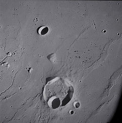
A wrinkle ridge is a type of feature commonly found on lunar maria, or basalt plains. These features are low, sinuous ridges formed on the mare surface that can extend for up to several hundred kilometers. Wrinkle ridges are tectonic features created after the lava cooled and solidified. They frequently outline ring structures buried within the mare, follow circular patterns outlining the mare, or intersect protruding peaks. They are sometimes called veins due to their resemblance to the veins that protrude from beneath the skin.

Contents

Wrinkle ridges are named with the Latin designation dorsum (plural dorsa). The standard IAU nomenclature uses the names of people (generally scientists) to identify wrinkle ridges on the Moon. For example, the Dorsa Burnet are named for Thomas Burnet, and the Dorsum Owen is named after George Owen of Henllys.

Wrinkle ridges can also be found on Mars, for example in Chryse Planitia, on several of the asteroids that have been visited by spacecraft, on Mercury, and certain moons of Jupiter and Saturn. Although several hypotheses have been advanced as causes of wrinkle ridges, today they are generally considered to be of tectonic origin. They involve folding and faulting. [1] If correctly interpreted as thrust faults, where a rupture occurs and one side of the rupture is pushed on top of the other, they are evidence of compressional stress in planetary crust. [2]

Examples on the Moon

Examples on Mars

Examples on Mercury

See also

Related Research Articles

<span class="mw-page-title-main">Mare Crisium</span> Feature on the moon

Mare Crisium is a lunar mare located in the Moon's Crisium basin, just northeast of Mare Tranquillitatis. Mare Crisium is a basin of Nectarian age.

<span class="mw-page-title-main">Alba Mons</span> Martian volcano

Alba Mons is a volcano located in the northern Tharsis region of the planet Mars. It is the biggest volcano on Mars in terms of surface area, with volcanic flow fields that extend for at least 1,350 km (840 mi) from its summit. Although the volcano has a span comparable to that of the United States, it reaches an elevation of only 6.8 km (22,000 ft) at its highest point. This is about one-third the height of Olympus Mons, the tallest volcano on the planet. The flanks of Alba Mons have very gentle slopes. The average slope along the volcano's northern flank is 0.5°, which is over five times lower than the slopes on the other large Tharsis volcanoes. In broad profile, Alba Mons resembles a vast but barely raised welt on the planet's surface. It is a unique volcanic structure with no counterpart on Earth or elsewhere on Mars.

<span class="mw-page-title-main">Memnonia quadrangle</span> Map of Mars

The Memnonia quadrangle is one of a series of 30 quadrangle maps of Mars used by the United States Geological Survey (USGS) Astrogeology Research Program. The Memnonia quadrangle is also referred to as MC-16.

<span class="mw-page-title-main">Geology of Mars</span> Scientific study of the surface, crust, and interior of the planet Mars

The geology of Mars is the scientific study of the surface, crust, and interior of the planet Mars. It emphasizes the composition, structure, history, and physical processes that shape the planet. It is analogous to the field of terrestrial geology. In planetary science, the term geology is used in its broadest sense to mean the study of the solid parts of planets and moons. The term incorporates aspects of geophysics, geochemistry, mineralogy, geodesy, and cartography. A neologism, areology, from the Greek word Arēs (Mars), sometimes appears as a synonym for Mars's geology in the popular media and works of science fiction. The term areology is also used by the Areological Society.

<span class="mw-page-title-main">Medusae Fossae Formation</span> Large geological unit of uncertain origin on Mars

The Medusae Fossae Formation is a large geological formation of probable volcanic origin on the planet Mars. It is named for the Medusa of Greek mythology. "Fossae" is Latin for "trenches". The formation is a collection of soft, easily eroded deposits that extends discontinuously for more than 5,000 km along the equator of Mars. Its roughly-shaped regions extend from just south of Olympus Mons to Apollinaris Patera, with a smaller additional region closer to Gale Crater.

<span class="mw-page-title-main">Arabia quadrangle</span> Map of Mars

The Arabia quadrangle is one of a series of 30 quadrangle maps of Mars used by the United States Geological Survey (USGS) Astrogeology Research Program. The Arabia quadrangle is also referred to as MC-12.

<span class="mw-page-title-main">Amazonis quadrangle</span> Map of Mars

The Amazonis quadrangle is one of a series of 30 quadrangle maps of Mars used by the United States Geological Survey (USGS) Astrogeology Research Program. The Amazonis quadrangle is also referred to as MC-8.

<span class="mw-page-title-main">Mare Tyrrhenum quadrangle</span> Part of the surface of Mars

The Mare Tyrrhenum quadrangle is one of a series of 30 quadrangle maps of Mars used by the United States Geological Survey (USGS) Astrogeology Research Program. This quadrangle is also referred to as MC-22. It contains parts of the regions Tyrrhena Terra, Hesperia Planum, and Terra Cimmeria.

<span class="mw-page-title-main">Thaumasia quadrangle</span> Map of Mars

The Thaumasia quadrangle is one of a series of 30 quadrangle maps of Mars used by the United States Geological Survey (USGS) Astrogeology Research Program. The Thaumasia quadrangle is also referred to as MC-25 . The name comes from Thaumas, the god of the clouds and celestial apparitions.

<span class="mw-page-title-main">Mare Australe quadrangle</span> Map of Mars

The Mare Australe quadrangle is one of a series of 30 quadrangle maps of Mars used by the United States Geological Survey (USGS) Astrogeology Research Program. The Mare Australe quadrangle is also referred to as MC-30. The quadrangle covers all the area of Mars south of 65°, including the South polar ice cap, and its surrounding area. The quadrangle's name derives from an older name for a feature that is now called Planum Australe, a large plain surrounding the polar cap. The Mars polar lander crash landed in this region.

<span class="mw-page-title-main">Ceraunius Fossae</span> Set of fractures in the northern Tharsis region of Mars

The Ceraunius Fossae are a set of fractures in the northern Tharsis region of Mars. They lie directly south of the large volcano Alba Mons and consist of numerous parallel faults and tension cracks that deform the ancient highland crust. In places, younger lava flows cover the fractured terrain, dividing it into several large patches or islands. They are found in the Tharsis quadrangle.

<span class="mw-page-title-main">Phlegra Montes</span> System of eroded massifs and knobbly terrain on Mars

The Phlegra Montes are a system of eroded Hesperian–Noachian-aged massifs and knobby terrain in the mid-latitudes of the northern lowlands of Mars, extending northwards from the Elysium Rise towards Vastitas Borealis for nearly 1,400 km (870 mi). The mountain ranges separate the large plains provinces of Utopia Planitia (west) and Amazonis Planitia (east), and were named in the 1970s after a classical albedo feature. The massif terrains are flanked by numerous parallel wrinkle ridges known as the Phlegra Dorsa.

<span class="mw-page-title-main">Lineated valley fill</span> Martian geologic feature

Lineated valley fill (LVF), also called lineated floor deposit, is a feature of the floors of some channels on Mars, exhibiting ridges and grooves that seem to flow around obstacles. Shadow measurements show that at least some of the ridges are several metres high. LVF is believed to be ice-rich. Hundreds of metres of ice probably lie protected in LVF under a thin layer of debris. The debris consists of wind-borne dust, material from alcove walls, and lag material remaining after ice sublimated from a rock-ice mixture. Some glaciers on Earth show similar ridges. High-resolution pictures taken with HiRISE reveal that some of the surfaces of lineated valley fill are covered with strange patterns called closed-cell and open-cell brain terrain. The terrain resembles a human brain. It is believed to be caused by cracks in the surface accumulating dust and other debris, together with ice sublimating from some of the surfaces. The cracks are the result stress from gravity and seasonal heating and cooling. This same type of surface is present on Lobate debris aprons and Concentric crater fill so all three are believed to be related.

<span class="mw-page-title-main">Hesperian</span> Era of Mars geologic history

The Hesperian is a geologic system and time period on the planet Mars characterized by widespread volcanic activity and catastrophic flooding that carved immense outflow channels across the surface. The Hesperian is an intermediate and transitional period of Martian history. During the Hesperian, Mars changed from the wetter and perhaps warmer world of the Noachian to the dry, cold, and dusty planet seen today. The absolute age of the Hesperian Period is uncertain. The beginning of the period followed the end of the Late Heavy Bombardment and probably corresponds to the start of the lunar Late Imbrian period, around 3700 million years ago (Mya). The end of the Hesperian Period is much more uncertain and could range anywhere from 3200 to 2000 Mya, with 3000 Mya being frequently cited. The Hesperian Period is roughly coincident with the Earth's early Archean Eon.

<span class="mw-page-title-main">Hesperia Planum</span> Broad lava plain in the southern highlands of the planet Mars

Hesperia Planum is a broad lava plain in the southern highlands of the planet Mars. The plain is notable for its moderate number of impact craters and abundant wrinkle ridges. It is also the location of the ancient volcano Tyrrhena Mons. The Hesperian time period on Mars is named after Hesperia Planum.

<span class="mw-page-title-main">Glaciers on Mars</span> Extraterrestrial bodies of ice

Glaciers, loosely defined as patches of currently or recently flowing ice, are thought to be present across large but restricted areas of the modern Martian surface, and are inferred to have been more widely distributed at times in the past. Lobate convex features on the surface known as viscous flow features and lobate debris aprons, which show the characteristics of non-Newtonian flow, are now almost unanimously regarded as true glaciers.

<span class="mw-page-title-main">Groundwater on Mars</span> Water held in permeable ground

Rain and snow was a regular occurrence on Mars in the past; especially in the Noachian and early Hesperian epochs. Some moisture entered the ground and formed aquifers. That is, the water went into the ground, seeped down until it reached a formation that would not allow it to penetrate further. Water then accumulated forming a saturated layer. Deep aquifers may still exist.

The common surface features of Mars include dark slope streaks, dust devil tracks, sand dunes, Medusae Fossae Formation, fretted terrain, layers, gullies, glaciers, scalloped topography, chaos terrain, possible ancient rivers, pedestal craters, brain terrain, and ring mold craters.

Linear ridge networks are found in various places on Mars in and around craters. These features have also been called "polygonal ridge networks," "boxwork ridges", and "reticulate ridges." Ridges often appear as mostly straight segments that intersect in a lattice-like manner. They are hundreds of meters long, tens of meters high, and several meters wide. It is thought that impacts created fractures in the surface, these fractures later acted as channels for fluids. Fluids cemented the structures. With the passage of time, surrounding material was eroded away, thereby leaving hard ridges behind. It is reasonable to think that on Mars impacts broke the ground with cracks since faults are often formed in impact craters on Earth. One could guess that these ridge networks were dikes, but dikes would go more or less in the same direction, as compared to these ridges that have a large variety of orientations. Since the ridges occur in locations with clay, these formations could serve as a marker for clay which requires water for its formation. Water here could have supported past life in these locations. Clay may also preserve fossils or other traces of past life.

<span class="mw-page-title-main">Thaumasia Planum</span>

The Thaumasia Planum of Mars lies south of Melas Chasmata and Coprates Chasmata. It is in the Coprates quadrangle. Its center is located at 21.66 S and 294.78 E. It was named after a classical albedo feature. The name was approved in 2006. Some forms on its surface are evidence of a flow of lava or water the Melas Chasma. Many wrinkle ridges and grabens are visible. One set of grabens, called Nia Fossae, seem to follow the curve of Melas Chasmata which lies just to the north.

References

  1. Kieffer, H, B. Jakosky, C. Snyder, M. Matthews (eds.). 1992. Mars. University of Arizona Press.
  2. "HiRISE | Wrinkle Ridges and Pit Craters (ESP_046817_1775)". Uahirise.org. 2016-10-19. Retrieved 2018-10-22.

Notes