Wyocena, Wisconsin | |
---|---|
Location of Wyocena in Columbia County, Wisconsin. | |
Coordinates: 43°30′40″N89°18′21″W / 43.51111°N 89.30583°W Coordinates: 43°30′40″N89°18′21″W / 43.51111°N 89.30583°W | |
Country | United States |
State | Wisconsin |
County | Columbia |
Area | |
• Total | 1.56 sq mi (4.04 km2) |
• Land | 1.43 sq mi (3.71 km2) |
• Water | 0.13 sq mi (0.33 km2) |
Elevation | 794 ft (242 m) |
Population | |
• Total | 768 |
• Estimate (2019) [4] | 725 |
• Density | 505.58/sq mi (195.20/km2) |
Time zone | UTC-6 (Central (CST)) |
• Summer (DST) | UTC-5 (CDT) |
FIPS code | 55-89325 [5] |
GNIS feature ID | 1577066 [2] |
Website | www |
Wyocena is a village in Columbia County, Wisconsin, United States. The population was 768 at the 2010 census. The village is located within the Town of Wyocena. It is part of the Madison Metropolitan Statistical Area.
A tornado struck the village on April 25, 2008 destroying several homes. [6]
Wyocena is located at 43°29′39″N89°18′33″W / 43.49417°N 89.30917°W (43.494319, -89.309191). [7]
According to the United States Census Bureau, the village has a total area of 1.55 square miles (4.01 km2), of which, 1.42 square miles (3.68 km2) of it is land and 0.13 square miles (0.34 km2) is water. [8]
Wyocena is served by Wis 16 and Wis 22. Wis 16 heads east to Columbus and west to Poynette and Portage. Wis 22 heads north to Pardeeville and Montello and south to US Route 51 at North Leeds. Wis 22 South is the most direct way to get to Madison via US 51 South.
Historical population | |||
---|---|---|---|
Census | Pop. | %± | |
1850 | 101 | — | |
1870 | 270 | — | |
1880 | 219 | −18.9% | |
1910 | 425 | — | |
1920 | 425 | 0.0% | |
1930 | 490 | 15.3% | |
1940 | 706 | 44.1% | |
1950 | 714 | 1.1% | |
1960 | 747 | 4.6% | |
1970 | 809 | 8.3% | |
1980 | 548 | −32.3% | |
1990 | 620 | 13.1% | |
2000 | 668 | 7.7% | |
2010 | 768 | 15.0% | |
2019 (est.) | 725 | [4] | −5.6% |
U.S. Decennial Census [9] |
As of the census [3] of 2010, there were 768 people, 271 households, and 170 families living in the village. The population density was 540.8 inhabitants per square mile (208.8/km2). There were 296 housing units at an average density of 208.5 per square mile (80.5/km2). The racial makeup of the village was 98.3% White, 0.1% African American, 0.4% Native American, 0.3% Asian, and 0.9% from two or more races. Hispanic or Latino of any race were 2.0% of the population.
There were 271 households, of which 31.4% had children under the age of 18 living with them, 48.7% were married couples living together, 10.3% had a female householder with no husband present, 3.7% had a male householder with no wife present, and 37.3% were non-families. 31.7% of all households were made up of individuals, and 8.1% had someone living alone who was 65 years of age or older. The average household size was 2.38 and the average family size was 2.95.
The median age in the village was 43.5 years. 20.2% of residents were under the age of 18; 6.2% were between the ages of 18 and 24; 25.1% were from 25 to 44; 23.3% were from 45 to 64; and 25.1% were 65 years of age or older. The gender makeup of the village was 46.5% male and 53.5% female.
As of the census [5] of 2000, there were 668 people, 226 households, and 145 families living in the village. The population density was 466.3 people per square mile (180.4/km2). There were 241 housing units at an average density of 168.2 per square mile (65.1/km2). The racial makeup of the village was 97.90% White, 0.15% Black or African American, 0.15% Native American, 1.35% Asian, 0.15% from other races, and 0.30% from two or more races. 1.20% of the population were Hispanic or Latino of any race.
There were 226 households, out of which 31.4% had children under the age of 18 living with them, 51.3% were married couples living together, 8.0% had a female householder with no husband present, and 35.8% were non-families. 27.9% of all households were made up of individuals, and 11.1% had someone living alone who was 65 years of age or older. The average household size was 2.37 and the average family size was 2.94.
In the village, the population was spread out, with 19.5% under the age of 18, 6.1% from 18 to 24, 26.8% from 25 to 44, 18.9% from 45 to 64, and 28.7% who were 65 years of age or older. The median age was 43 years. For every 100 females, there were 92.0 males. For every 100 females age 18 and over, there were 90.1 males.
The median income for a household in the village was $42,857, and the median income for a family was $50,875. Males had a median income of $35,417 versus $24,464 for females. The per capita income for the village was $17,430. About 2.8% of families and 5.0% of the population were below the poverty line, including 7.8% of those under age 18 and none of those age 65 or over.
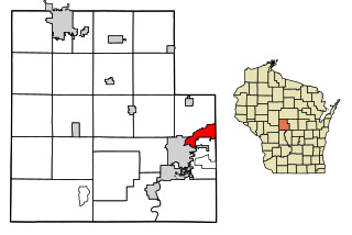
Pardeeville is a village in Columbia County, Wisconsin, United States. The population was 2,115 at the 2010 census. It is part of the Madison Metropolitan Statistical Area.
Lynxville is a village in Crawford County, Wisconsin, United States. The population was 132 at the 2010 census.
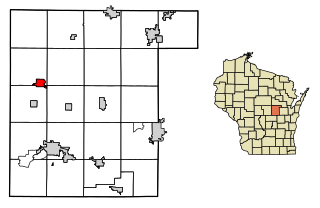
St. Cloud is a village in Fond du Lac County, Wisconsin, United States, along the Sheboygan River. The population was 477 at the 2010 census. St. Cloud is part of The Holyland region in northeastern Fond du Lac County.
Boaz is a village in Richland County, Wisconsin, United States. The population was 156 at the 2010 census.
Rock Springs is a village in Sauk County, Wisconsin, United States, along the Baraboo River. The population was 362 at the 2010 census.
Cecil is a village in Shawano County, Wisconsin, United States. The population was 570 at the 2010 census.
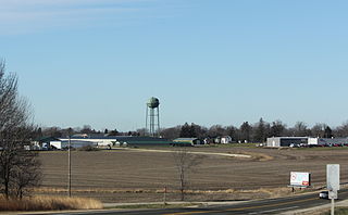
Cascade is a village in Sheboygan County, Wisconsin, United States. The population was 709 at the 2010 census. It is included in the Sheboygan, Wisconsin Metropolitan Statistical Area. Wisconsin Highway 28 passes through Cascade.
Stoddard is a village in Vernon County, Wisconsin, United States. The population was 774 at the 2010 census.
Biron is a village in Wood County, Wisconsin, United States. The population was 839 at the 2010 census. It is the site of Catalyst Paper's Biron Mill.
Wrightstown is a village in Brown and Outagamie counties in the U.S. state of Wisconsin. The population was 2,827 at the 2010 census. Of this, 2,676 were in Brown County, and 151 were in Outagamie County. The village is surrounded mostly by the westernmost part of the Town of Wrightstown in Brown County. On February 28, 2002, the village annexed a portion of land within the adjacent Town of Kaukauna in Outagamie County.
Arlington is a village in Columbia County, Wisconsin, United States. The population was 819 at the 2010 census. The village is located within the Town of Arlington. It is part of the Madison Metropolitan Statistical Area.
Wyocena is a town in Columbia County, Wisconsin, United States. The population was 1,543 at the 2000 Census. The Village of Wyocena is located within the town. Wyocena is part of the Madison, WI Metropolitan Statistical Area.
Wauzeka is a village in Crawford County, Wisconsin, United States. The population was 728 at the 2010 census. The village is located within the Town of Wauzeka.
Oakfield is a town in Fond du Lac County, Wisconsin, United States. The population was 767 at the 2000 census. The Village of Oakfield is located within the town. The unincorporated community of Oak Center is also located in the town.
Rosendale is a village in Fond du Lac County, Wisconsin, United States. The population was 1,063 at the 2010 census. The village is located partially within the Town of Rosendale and partially within the Town of Springvale.
Necedah is a village in Juneau County, Wisconsin, United States. The population was 916 at the 2010 census. The village is located within the Town of Necedah.
Mishicot is a village in Manitowoc County, Wisconsin, United States. The population was 1,442 at the 2010 census. The village is adjacent to the Town of Mishicot.
Montello is a city in and the county seat of Marquette County, Wisconsin, United States. The population was 1,495 at the 2010 census. The Fox River flows through the city. Montello is home to the largest tree in Wisconsin. A notable attraction in the city is the former granite quarry, which has been transformed into a park with several waterfalls.
Oxford is a village in Marquette County, Wisconsin, United States. The population was 607 at the 2010 census. The village is located within the Town of Oxford. The Union Pacific Railroad runs through the town and over Neenah Lake to the northwest.
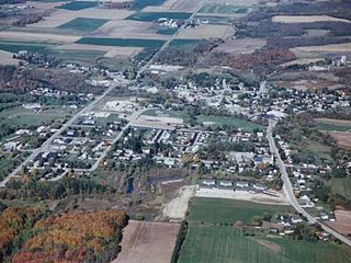
Iola is a village in Waupaca County, Wisconsin, United States. The population was 1,301 at the 2010 census. The village is bordered by the towns of Iola and Scandinavia. The community was named after a Potawatomi girl.
Wikimedia Commons has media related to Wyocena, Wisconsin . |