
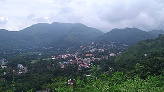
Dharamshala is a town in the Indian state of Himachal Pradesh. It serves as the winter capital of the state and the administrative headquarters of the Kangra district since 1855. The town also hosts the Tibetan Government-in-exile. Dharamshala was a municipal council until 2015, when it was upgraded to a municipal corporation.

Manali is a town, near Kullu town in Kullu district in the Indian state of Himachal Pradesh. It is situated in the northern end of the Kullu Valley, formed by the Beas River. The town is located in the Kullu district, approximately 270 kilometres (170 mi) north of the state capital of Shimla and 544 kilometres (338 mi) northeast of the national capital of New Delhi. With a population of 8,096 people recorded in the 2011 Indian census Manali is the beginning of an ancient trade route through Lahaul (H.P) and Ladakh, over the Karakoram Pass and onto Yarkand and Hotan in the Tarim Basin of China. Manali is a popular tourist destination in India and serves as the gateway to the Lahaul and Spiti district as well as the city of Leh in Ladakh.

Una is a City and a Municipal Council in Una district in the Indian state of Himachal Pradesh. It serves as the headquarters of Una district. There are 11 wards under Municipal Council. Una City is home to the Kila, which is a historical fort and an ancestral home of the descendants of the first guru of the Sikhs, Guru Nanak.

Kangra is a city and a municipal council in Kangra district in the Indian state of Himachal Pradesh. It is also known as Nagarkot.

Pathankot is a city and the district headquarters of the Pathankot district in Punjab, India. Pathankot is the 6th most populous city of Punjab, after Ludhiana, Amritsar, Jalandhar, Patiala and Bathinda. Its local government is a municipal corporation.
Palampur is a hill station and a municipal corporation situated in the Kangra District in the Indian state of Himachal Pradesh.
Gagret is a nagar panchayat in Tehsil Ghanari of Una district in the state of Himachal Pradesh, India. It is situated in plains of Una.
Nagrota Bagwan is a town and a municipal council in Kangra district in the Indian state of Himachal Pradesh. It is an important town situated in Kangra valley around a serene lap of Dhauladhar Mountain Range. It is a major market area with numerous stores and showrooms. The area also has an industrial area with small-scale industries. There are various automobile showrooms around the town. It is located within the center of 3 main towns of the valley: Dharamshala, Palampur, and Kangra.
Nurpur is a city and a municipal council in Kangra district in the Indian state of Himachal Pradesh. It was formerly part of the Nurpur State since the 11th century AD. The capital of the state was at Pathankot formerly known as Paithan, now in Punjab.It got its name from wife of Mughal emperor Jahangir, Nur Jahan, when they visited Kangra (Nagarkot) after Jahangir's successful conquest of the Kangra Fort.
Sujanpur is a city and municipal council in the Pathankot district of the Indian state of Punjab. It is 06 km from Pathankot towards Jammu on Jalandhar-Jammu-Amritsar National Highway (NH-1A). It is situated near the banks of Ravi River and surrounded by two canals: UBDC and Bias Link. Sujanpur Municipal Council area is divided into 15 wards.
Sundar Nagar is a town and a municipal council in Mandi district in the Indian state of Himachal Pradesh. It was formerly a princely state, known as Suket.
Dalhousie cantonment is a town in Dalhousie, just 50 km from Chamba town in Chamba district in the state of Himachal Pradesh, India.
Jogindernagar, or Jogindar Nagar, is a municipality, and a sub district in Mandi district in the Indian state of Himachal Pradesh. Named after Raja Joginder Sen, the hill station is the terminus of the 163-kilometre-long (101 mi) Kangra Valley narrow-gauge railway. Jogindernagar is the third-largest city in the Mandi district. The only city in Asia with three hydro-electric power stations, its nickname is "The City of Powerhouses".
Rehan is a small town in the Kangra district of Himachal Pradesh state, in the north of India. It lies on the border of Punjab and Himachal Pradesh. It is well-known as a juncture between the cities of Nurpur, Jawali and Pathankot. Pathankot is the nearest and largest city with two railway stations. It is also the place of Freedom fighter and then MLA of the constituency from 1952 to 1972 Comrade Shr. Ram Chandar, one of the close associates of Shaheed Bhagat Singh.

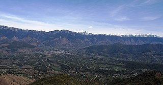
Kangra Valley is a river valley situated in the Western Himalayas. It lies in the state of Himachal Pradesh in India, and is a popular tourist destination. The Kangri language is spoken there. Dharamshala, the headquarters of Kangra district and the main city of the valley, lies on the southern spur of Dhauladhar.
McLeod Ganj or McLeodganj is a suburb of Dharamshala in Kangra district, Himachal Pradesh, India. It is known as "Little Lhasa" or "Dhasa" as the Tibetan government-in-exile is headquartered here and there is a significant population of Tibetans in the region.

Bir Tibetan Colony is a Tibetan refugee settlement in the Himalayan village of Chowgan adjacent to the town of Bir, in the north Indian state of Himachal Pradesh.
Jawali is a town in Kangra District of Himachal Pradesh State in India.Old name of Jawali is Jawanwalashehar. Jawali is the second largest Assembly constituency in the state of Himachal Pradesh. It is located 250 km distance from its State Capital, Shimla and is located 50 km distance from its District headquarters Dharamshala.
Nagrota Surian is a town in Nagrota Surian Mandal, Kangra District, in the Indian state of Himachal Pradesh. Nagrota Surian is 45.2 km from the district headquarters Dharamshala. It is about 260 km from the state capital Shimla. Block Head office is also available in Nagrota surian.
Ichhi is a village and a Village Panchayat in Kangra district in the Indian state of Himachal Pradesh. Ichhi village is 8 kilometres from Kangra.

