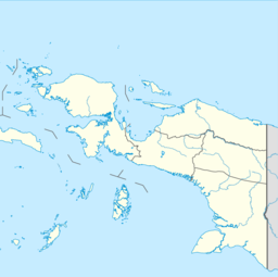
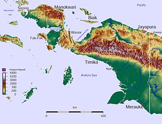
Papua is a province of Indonesia, comprising the northern coast of Western New Guinea together with island groups in Cenderawasih Bay to the west. It roughly follows the borders of Papuan customary region of Tabi Saireri. It is bordered by the sovereign state of Papua New Guinea to the east, the Pacific Ocean to the north, Cenderawasih Bay to the west, and the provinces of Central Papua and Highland Papua to the south. The province also shares maritime boundaries with Palau in the Pacific. Following the splitting off of twenty regencies to create the three new provinces of Central Papua, Highland Papua, and South Papua on 30 June 2022, the residual province is divided into eight regencies (kabupaten) and one city (kota), the latter being the provincial capital of Jayapura. The province has a large potential in natural resources, such as gold, nickel, petroleum, etc. Papua, along with five other Papuan provinces, has a higher degree of autonomy level compared to other Indonesian provinces.

Dutch New Guinea or Netherlands New Guinea was the western half of the island of New Guinea that was a part of the Dutch East Indies until 1949, later an overseas territory of the Kingdom of the Netherlands from 1949 to 1962. It contained what are now Indonesia's six easternmost provinces, Central Papua, Highland Papua, Papua, South Papua, Southwest Papua, and West Papua, which were administered as a single province prior to 2003 under the name Irian Jaya, and now comprise the Papua region of the country.
Jayapura is the capital and largest city of the Indonesian province of Papua. It is situated on the northern coast of New Guinea island and covers an area of 940.0 km2 (362.9 sq mi). The city borders the Pacific Ocean and Yos Sudarso Bay to the north, the sovereign state of Papua New Guinea to the east, Keerom Regency to the south, and Jayapura Regency to the west.

West Papua, formerly Irian Jaya Barat, is a province of Indonesia. It covers the two western peninsulas of the island of New Guinea, the eastern half of the Bird's Head Peninsula and the Bomberai Peninsula, along with nearby smaller islands. The province is bordered to the north by the Pacific Ocean, to the west by Southwest Papua, the Halmahera Sea and the Ceram Sea, to the south by the Banda Sea, and to the east by the province of Central Papua and the Cenderawasih Bay. Manokwari is the province's capital and largest city. West Papua is the second-least populous province in Indonesia. It had a population of 1,134,068 at the 2020 Census, and the official estimate for mid-2022 was 1,183,307. However, the total area and population was reduced by the Parliamentary decision on 17 November 2022 to create a 38th province of Indonesia, comprising Sorong city and the regencies of Sorong, South Sorong, Raja Ampat, Maybrat and Tambrauw; this new province, called Southwest Papua, came into existence from 8 December 2022. The reduced West Papua Province thus had a mid-2022 population estimated at only 561,403.

Biak is an island located in Cenderawasih Bay near the northern coast of Papua, an Indonesian province, and is just northwest of New Guinea. Biak is the largest island in its small archipelago, and has many atolls, reefs, and corals.
Pulau Yos Sudarso or Pulau Dolok is an island separated only by the narrow Muli Strait from the main island of New Guinea. It is part of the Merauke Regency, in the Indonesian province of South Papua. The island is leaf-shaped, about 165 km (103 mi) long with an area of 11,740 km2 (4,530 sq mi). It was known as Frederik Hendrik Island until 1963. Local and alternative names of the island include Dolok, Kimaam and Kolepom.

Commodore Yosaphat "Yos" Sudarso was an Indonesian naval officer killed at the Battle of Arafura Sea. At the time of his death, Yos Sudarso was deputy chief of staff of the Indonesian Navy and in charge of an action to infiltrate Dutch New Guinea. He was promoted to vice admiral posthumously.

The Battle of Hollandia was an engagement between Allies of World War II and Japanese forces during World War II. The majority of the Allied force was provided by the United States, with the bulk of two United States Army infantry divisions being committed on the ground. Air and naval support consisted largely of U.S. assets, although Australia also provided air support during preliminary operations and a naval bombardment force.

Tanahmerah Bay, or Tanah Merah Bay, is a bay on the north coast of New Guinea, in Jayapura Regency, Papua, Indonesia, about 50 km northwest of the provincial capital of Jayapura.

The Mombum languages, also known as the Komolom or Muli Strait languages, are a pair of Trans–New Guinea languages, Mombum (Komolom) and Koneraw, spoken on Komolom Island just off Yos Sudarso Island, and on the southern coast of Yos Sudarso Island, respectively, on the southern coast of New Guinea. Komolom Island is at the southern end of the Muli Strait.

New Guinea is the world's second-largest island, with an area of 785,753 km2 (303,381 sq mi). Located in Oceania in the southwestern Pacific Ocean, the island is separated from Australia by the 150-kilometre wide Torres Strait, though both landmasses lie on the same continental shelf. Numerous smaller islands are located to the west and east.
The History of Western New Guinea refers to the history of the Indonesian western half of the island of New Guinea and other smaller islands to its west. This region was previously named Irian Jaya. The eastern half of the island is Papua New Guinea.

Lake Sentani is a tropical, shallow, and at low-altitude open lake located at the northeast extremity of the Jayapura Regency in the Indonesian province of Papua, about 20 kilometres (12 mi) from the provincial capital, Jayapura City. It is located just to the south of the town of Sentani.

Major TNI Marthen Indey (1912–1986) was a colonial police officer in New Guinea, Dutch East Indies who later became nationalist fighter in the Indonesian National Revolution and a supporter of Papua becoming part of Indonesia. He was declared a National Hero of Indonesia in 1993 along with two other people of Papuan descent, Frans Kaisiepo and Silas Papare.

Silas Ayari Donrai Papare was a Papuan–Indonesian politician and guerilla leader who is a National Hero of Indonesia.

The Battle of Arafura Sea, also known as the Battle of Vlakke Hoek, was a naval battle in the Vlakke Hoek Bay of the Arafura Sea in Western New Guinea on January 15, 1962, between Indonesia and the Netherlands.
The West New Guinea dispute (1950–1962), also known as the West Irian dispute, was a diplomatic and political conflict between the Netherlands and Indonesia over the territory of Dutch New Guinea. While the Netherlands had ceded sovereignty over most of the Dutch East Indies to Indonesia on 27 December 1949 following an independence struggle, it retained control over its colony on the western half of New Guinea. The Indonesian government claimed this territory as well, on the basis that it had belonged to the Dutch East Indies and that the new Republic of Indonesia was the legitimate successor to the former Dutch colony.

Naval Base Hollandia was a United States Navy base built during World War II at Humboldt Bay, near the city of Hollandia in New Guinea. The base was built by the US Navy Seabees during the Battle of Hollandia, starting on May 9, 1944. Later Naval Base Hollandia became a supply base to support the invasion of the Philippines that started on October 20, 1944. Naval Base Hollandia became an advance headquarter of the United States Seventh Fleet.
The Japanese occupation of New Guinea was the military occupation of the island of New Guinea by the Empire of Japan from 1941 to 1945 during World War II when Japanese forces captured the city of Rabaul.