Young, New South Wales

Last updated

Young
New South Wales
YoungCourthouse.JPG
Young courthouse built in 1884 but transferred to the Department of Education in 1925 and used as the main hall of Young High School
Australia New South Wales relief location map.png
Red pog.svg
Young
Coordinates 34°18′0″S148°18′0″E / 34.30000°S 148.30000°E / -34.30000; 148.30000
Population7,712 (UCL 2021) [1]
Established1826
Postcode(s) 2594
Elevation440 m (1,444 ft)
Location
LGA(s) Hilltops Council
County Monteagle
State electorate(s) Cootamundra
Federal division(s) Riverina
Mean max tempMean min tempAnnual rainfall
22.2 °C
72 °F
7.1 °C
45 °F
626.2 mm
24.7 in

Young is a town in the South Western Slopes region of New South Wales, Australia and the largest town in the Hilltops Region. The "Lambing Flat" Post Office opened on 1 March 1861 and was renamed "Young" in 1863. [2]

Contents

Young is marketed as the Cherry Capital of Australia and every year hosts the National Cherry Festival. [3] Young is situated on the Olympic Highway and is approximately 2 hours drive from the Canberra area. It is in a valley, with surrounding hills. The town is named after Sir John Young, the governor of NSW from 1861 to 1867. [4] [5]

History

Brass breast plate presented to the Aboriginal leader Coborn Jackey of the Burrowmunditory tribe by the squatter James White. The artifact is held in the museum at Young. BreastplateCobornJackey.jpg
Brass breast plate presented to the Aboriginal leader Coborn Jackey of the Burrowmunditory tribe by the squatter James White. The artifact is held in the museum at Young.

Before European settlers arrived in Young, members of the Burrowmunditory tribe, a family group of the indigenous Wiradjuri Nation, lived in the region. [7] Descendants of the Burrowmunditory clan still live in Young. [8]

James White was the first European settler in the district and established 'Burrangong' station in 1826 with a squatting claim of 260 square kilometres (100 sq mi). [6] [7] His story is told in the novel Brothers in Exile.

In late June 1860 Michael Sheedy from Binalong, and a group of other stockmen, were on James White's 'Burrangong' pastoral run looking for horses. [9] The sheltered area known as 'Lambing Flat' lay along a creek between heavily timbered hills. Stock yards had been built there and used to enclose strayed and wild horses from the surrounding country. [10] The cook for the party, an American, "who was familiar with the appearance of many other goldfields, was struck with the appearance of the place". The cook washed several spadefuls of earth "and succeeded in getting a good prospect of gold". After procuring the horses the men returned to Binalong, 32 miles to the south-east, and after a few days Sheedy and six men returned with tools and provisions, "determined to test the auriferous quality of the place". The second dishful washed by the men produced a nugget of seven pennyweight. By late July 1860 word had spread and there were about fifty persons at Lambing Flat who had joined the search for gold. [11]

From November 1860 through to June 1861, anti-Chinese miners attacked Chinese gold miners in the area, now known as the infamous Lambing Flat riots. As gold became scarce, European miners began to resent what they saw as the greater success of the more industrious Chinese, and hence many Chinese miners were attacked, robbed and killed. The anti-Chinese rebels rallied in numbers of up to 3,000. Eventually the rioters were controlled, Chinese miners had their claims restored to them, but the New South Wales Parliament passed the Chinese Immigration Bill which restricted the number of Chinese that could be brought into New South Wales on any ship and imposed a tax per head on entry.

The town of Young was gazetted in 1861. The goldfields produced 15,000 kilograms (470,000 ozt) of gold sent by escort from the fields. Up to 20,000 miners worked the fields including about 2,000 Chinese miners. [7]

Later in the 1860s, some Chinese, who remained in the district, ran intensive and successful market gardens, supplying Young and other towns, even as far away as Wagga. [12]

The town was incorporated in 1882, with miller, Peter Cram, the first mayor. [13]

In 1889 Young was the first town in Australia to install electricity into the streets and homes of the township; Tamworth NSW had installed electricity to the streets only the previous year.

The former Young Shire was acknowledged as the first Local Government Area to institute a rural school bus system in New South Wales. [7]

Heritage listings

Young has a number of heritage-listed sites, including:

Climate

Owing to Young's far western location, it features hot, dry summers and cool, damp winters making for a particularly wide seasonal range characteristic of the South West Slopes region. Snow falls occasionally, notwithstanding its low elevation of just 400 metres (1,300 ft) as it lay far west enough to bear the brunt of the cold westerly airmasses. [17]

Climate data are sourced from Young Airport, at an elevation of 380 metres (1,250 ft) and operating since 1988.

Climate data for Young Airport (1988–2022); 380 m AMSL; 34.25° S, 148.25° E
MonthJanFebMarAprMayJunJulAugSepOctNovDecYear
Record high °C (°F)44.9
(112.8)
43.6
(110.5)
38.6
(101.5)
33.9
(93.0)
27.1
(80.8)
21.9
(71.4)
20.1
(68.2)
23.6
(74.5)
30.8
(87.4)
35.0
(95.0)
42.1
(107.8)
44.1
(111.4)
44.9
(112.8)
Mean daily maximum °C (°F)32.0
(89.6)
30.4
(86.7)
27.2
(81.0)
22.8
(73.0)
17.7
(63.9)
13.9
(57.0)
13.0
(55.4)
14.5
(58.1)
18.0
(64.4)
22.1
(71.8)
26.0
(78.8)
29.3
(84.7)
22.2
(72.0)
Mean daily minimum °C (°F)14.9
(58.8)
14.5
(58.1)
11.4
(52.5)
6.8
(44.2)
3.4
(38.1)
2.3
(36.1)
1.0
(33.8)
1.3
(34.3)
3.0
(37.4)
5.6
(42.1)
9.5
(49.1)
12.0
(53.6)
7.1
(44.8)
Record low °C (°F)1.4
(34.5)
2.3
(36.1)
0.4
(32.7)
−4.1
(24.6)
−5.8
(21.6)
−6.1
(21.0)
−7.0
(19.4)
−6.5
(20.3)
−5.5
(22.1)
−4.7
(23.5)
−2.5
(27.5)
−0.2
(31.6)
−7.0
(19.4)
Average precipitation mm (inches)45.6
(1.80)
51.1
(2.01)
49.7
(1.96)
33.4
(1.31)
42.2
(1.66)
61.1
(2.41)
58.8
(2.31)
52.7
(2.07)
51.8
(2.04)
50.0
(1.97)
71.2
(2.80)
55.0
(2.17)
626.2
(24.65)
Average precipitation days (≥ 0.2 mm)7.56.97.05.610.415.117.815.611.39.59.27.0122.9
Average afternoon relative humidity (%)31343540516363555144383145
Source: Australian Bureau of Meteorology [18]

Demographics

At the 2021 census, the population of Young was 10,610, [19] up from 10,295 people at the 2016 census. [20]

The breakdown of population in 2016 in the township included 367 people (5.1%) (197 males and 172 females) who identified as being of Indigenous origin. The median age of people was 40 years. [21]

The number of people born overseas in the 2016 Census was 1023 (13.9%) compared with 650 (5.8%) in the 2001 Census, 589 (5.3%) in the 1996 Census and 549 (5.1%) in the 1991 Census. Of those born overseas, the three main countries of birth in the 2016 Census were:

In the 2016 Census, the three most common ancestries identified with were:

English was stated as the only language spoken at home by 6,413 people (89.6%) in the 2016 Census. The three most common languages spoken at home other than English in the 2016 Census were:

In the week preceding the 2016 Census, 1894 households (67.8%) had accessed the internet at home. 501 (8.9%) people held a bachelor's degree or above. 212 people were unemployed, representing 7.6% of the labour force. The median weekly individual income for people aged 15 years and over in the 2016 Census was $505. In the 2016 Census, there were 2,324 separate houses (83.2%), 202 semi-detached, row or terrace houses and townhouses (7.2%), 257 flats, units or apartments (9.2%) and 3 other dwellings (0.1%). In the 2016 Census, there were 594 couple families with children (which comprised 34.4% of all families in occupied private dwellings), 675 couple families without children (39.1%), 431 one parent families (24.9%) and 28 other families (1.6%).

At the 2011 census, Young had a population of 6,960. [22]

The Lambing Flat Chinese Tribute Gardens

The Roll Up banner around which a mob of about 1,000 men rallied and attacked Chinese miners at Lambing Flat in June 1861. The banner is now on display in the museum at Young. LambingFlatRollUpBanner reworked.jpg
The Roll Up banner around which a mob of about 1,000 men rallied and attacked Chinese miners at Lambing Flat in June 1861. The banner is now on display in the museum at Young.

Young Shire Council established the Lambing Flat Chinese Tribute Gardens adjacent to the site of Chinamans Dam, an old railway dam approximately 4 kilometres (2.5 mi) south of Young. The gardens are intended to create an ambience similar to the Japanese Gardens at Cowra. Chinamans Dam, with an initial capacity of over 9,100 cubic metres (2×10^6 imp gal) when it was in railway use, is situated at a hamlet called Pitstone on Sawpit Gully. The dam was built in the 1860s by German brothers (from Hannover), Herman and John Tiedemann, to provide water for the sluicing of their Victoria Hill gold claims. At some time in the 1870s, the brothers sold the area, including the dam, to a Chinese group who worked the site. [23]

The dam was used as a railway facility from 1882 when the NSW Railway Commissioners gave notice of the intention to build the first part of the Blayney-Demondrille railway. To provide water for its steam locomotives, the Commissioners decided to provide a dam and pump water from it to a facility, known as Young Tank, at the 396-kilometre (246 mi) post. It is not known whether the railways enhanced the existing dam or built a new facility. [23]

From 1885 to 1901, locomotives stopped at Young Tank to replenish their water. In 1901, watering facilities were built at Young Station. The supply of water was obtained from Chinamans Dam. The capacity of the dam was enlarged in 1911. The dam was a popular spot for swimming and, whilst officially frowned upon, was tolerated. [23]

Following the connection to the South West Tablelands Water Supply Scheme, which provided water from Burrinjuck Dam, the railways ceased to draw water from Chinamans Dam after 1936. The site was returned to the Crown in 1962 and in the following year, a 15-hectare (36-acre) reserve was established and the Shire Council were appointed as trustees. The dam has since been enlarged. [23]

Education

Young has six schools:

Sport

Rugby football is traditionally popular in Young, with a strong Maher Cup rugby league team competing between 1920 and 1971. [24] [25]

The following sports teams operate out of Young:

Australian rules football was also at times popular in Young, with the Young Saints experiencing success in the Central West AFL in the 1980s, however despite attempts to revive it as a junior club, folded in 2018. [26]

Media

Newspapers

Radio stations

Churches

Notable people


Related Research Articles

<span class="mw-page-title-main">Mudgee</span> Town in New South Wales, Australia

Mudgee is a town in the Central West of New South Wales, Australia. It is in the broad fertile Cudgegong River valley 261 km (162 mi) north-west of Sydney and is the largest town in the Mid-Western Regional Council local government area as well as being the council seat. At the 2021 Census, its population was 11,457. The district lies across the edge of the geological structure known as the Sydney Basin.

<span class="mw-page-title-main">Forbes, New South Wales</span> Town in New South Wales, Australia

Forbes is a town in the Central West region of New South Wales, Australia, located on the Newell Highway between Parkes and West Wyalong. At the 2021 census, Forbes had a population of 9,319. Forbes is probably named after Sir Francis Forbes, first Chief Justice of NSW.

<span class="mw-page-title-main">Cowra</span> Town in New South Wales, Australia

Cowra is a small town in the Central West region of New South Wales, Australia. It is the largest population centre and the council seat for the Cowra Shire, with a population of 9,863.

<span class="mw-page-title-main">Lambing Flat riots</span> Series of violent anti-Chinese demonstrations in Australia

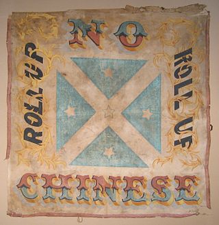
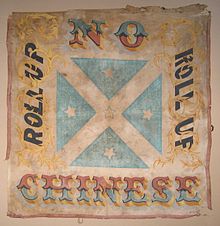
The Lambing Flat riots were a series of violent anti-Chinese demonstrations that took place in the Burrangong region, in New South Wales, Australia. They occurred on the goldfields at Spring Creek, Stoney Creek, Back Creek, Wombat, Blackguard Gully, Tipperary Gully, and Lambing Flat.

<span class="mw-page-title-main">Cootamundra</span> Town in New South Wales, Australia

Cootamundra, nicknamed Coota, is a town in the South West Slopes region of New South Wales, Australia and within the Riverina. It is within the Cootamundra-Gundagai Regional Council. At the 2016 Census, Cootamundra had a population of 6,782. It is located on the Olympic Highway at the point where it crosses the Muttama Creek, between Junee and Cowra. Its railway station is on the Main Southern line, part of the Melbourne-to-Sydney line.

<span class="mw-page-title-main">Captains Flat</span> Town in New South Wales, Australia

Captains Flat is a town in the Southern Tablelands of rural New South Wales, Australia, in Queanbeyan-Palerang Regional Council. It is south of Queanbeyan. Captains Flat township is bounded by the non-urban parts of the locality of Captains Flat in the north, east and west, and Captains Flat Road, the Molonglo River and Foxlow Street in the south.

<span class="mw-page-title-main">Grenfell, New South Wales</span> Town in New South Wales, Australia

Grenfell is a town in Weddin Shire in the Central West of New South Wales, Australia. It is 370 km (230 mi) west of Sydney. It is close to Forbes, Cowra and Young. At the 2011 census, Grenfell had a population of 1,996. The town is served daily by connecting NSW TrainLink services from Sydney via Bathurst and Lithgow. Grenfell is approximately 5 hours from Sydney and 2+12 hours from Canberra.

<span class="mw-page-title-main">Binalong</span> Town in New South Wales, Australia

Binalong is a village in the Southern Tablelands of New South Wales, Australia, 37 km north-west of Yass in Yass Valley Shire. At the 2016 census, Binalong and the surrounding area had a population of 543.

<span class="mw-page-title-main">Murringo</span> Town in New South Wales, Australia

Murringo is a small village in the southwestern slopes of New South Wales, Australia in Hilltops Council. It was once better known as Marengo. The name is also applied to the surrounding area, for postal and statistical purposes.

<span class="mw-page-title-main">Woodstock, New South Wales</span> Town in New South Wales, Australia

Woodstock is a village in the central west of New South Wales, Australia, 21 kilometres (13 mi) north east of Cowra. It contains remains of a brief goldrush during the late 19th century which left behind a number of substantial buildings before the village relapsed into relative isolation. It includes a restored railway station, hotel and a memorial hall. At the 2011 census, Woodstock had a population of 812.

<span class="mw-page-title-main">Central West (New South Wales)</span> Region in New South Wales, Australia

The Central West is a region in central New South Wales, Australia. The region is situated west of Sydney, which stretches from Lithgow in the east and to as far west as Lake Cargelligo, on the Lachlan River. The Central West is known for its attractions such as the Jenolan Caves, near Oberon and also wineries, as well as rural farmland and natural landscapes. The region includes major towns like, Bathurst, Orange, Mudgee, Lithgow, Parkes and Cowra. It has an area of 63,262 square kilometres (24,426 sq mi). The region also includes the sub-region known as the Central Tablelands, located in the eastern part of the region. The region known as the Orana, which includes the area surrounding Dubbo is typically classed as being a part of the Central West also.

Young was an electoral district for the Legislative Assembly in the Australian state of New South Wales, named after and including the town of Young. It elected two members between 1880 and 1894 and one member from 1894 to 1904, when it was replaced by Burrangong. The sitting member George Burgess (Labor) successfully contested Burrangong. In 1920, with the introduction of proportional representation, Burrangong was absorbed by the three member district of Cootamundra. Proportional representation was abandoned in 1927 and Young was recreated. It was abolished in 1981 and the district was split with Young being absorbed by Burrinjuck while the towns of Cowra and Forbes were absorbed by a re-created Lachlan.

<span class="mw-page-title-main">Wombat, New South Wales</span> Town in New South Wales, Australia

Wombat is a town in South West Slopes region of New South Wales, Australia. It is situated on the Olympic Highway, 15 kilometres (9.3 mi) south-west of the regional centre of Young. It is in the local government area of Hilltops Council.

John George Gough, was one of the founders of the New South Wales Labour Party, initially the Labour Electoral League, the first political Labour movement in Australia. He was also one of Labour's five-member leadership group when the party first made its appearance in the New South Wales parliament in 1891. Representing Young, he was first elected in 1889 to the parliament's lower house as a member of the Protectionist Party, which produced Australia's first two prime ministers, Edmund Barton and Alfred Deakin. From 1891 to 1894 he represented Labour. Proud that his mother was Australian-born, he was a strong nationalist and republican. John Gough's maternal grandmother was half-aboriginal. He is the only one of Labor's founding fathers who has been found to have had aboriginal ancestry.

<span class="mw-page-title-main">Timor, Victoria</span> Town in Victoria, Australia

Timor (/ˈtaɪˈmɔː/), short-speak for the adjoining localities of Bowenvale and Timor, in the Central Goldfields Shire of Victoria, Australia. Their shared boundary is 8 kilometres (5 mi) north of Maryborough, Victoria and 178 kilometres (111 mi) northwest of Melbourne, the state capital.

New South Wales experienced the first gold rush in Australia, a period generally accepted to lie between 1851 and 1880. This period in the history of New South Wales resulted in a rapid growth in the population and significant boost to the economy of the colony of New South Wales. The California Gold Rush three years prior signaled the impacts on society that gold fever would produce, both positive and negative. The New South Wales colonial government concealed the early discoveries, but various factors changed the policy.

<span class="mw-page-title-main">Wyangala</span> Town in New South Wales, Australia

Wyangala is a small village in the Lachlan Valley, near the junction of the Abercrombie and Lachlan Rivers, just below the Wyangala Dam wall. It is in the South West Slopes of New South Wales, Australia, and about 320 km (200 mi) west of the state capital, Sydney. The name is also used for the surrounding rural locality, which includes the site of the former mining village of Mount McDonald.

Margaret Turner Clarke was an Australian nurse and philanthropist. She was a pioneer within nursing in Australia. A student of the Florence Nightingale School for Nurses, she was the founder of the Visiting Relief Society in 1865, and a co-founder of the pioneer nursing education Home and Training School for Nurses in Sydney (1882).

<span class="mw-page-title-main">Blackguard Gully</span> Historic site in New South Wales, Australia

Blackguard Gully is a heritage-listed former Chinese mining camp and now reserve at Whiteman Avenue, Young, Hilltops Council, New South Wales, Australia. It was part of the Lambing Flat or Burragorang goldfields, and was a primary location of the anti-Chinese Lambing Flat riots of 1861. The property is owned by the Hilltops Council. It was added to the New South Wales State Heritage Register on 13 March 2009.

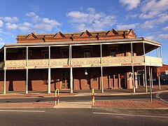
The Burrangong Argus was an Australian newspaper based in Young, New South Wales, published twice-weekly from 1865 to 1913. It was, at the time of its closure, the oldest newspaper in Young. It sold at 6d per copy, then 3d per copy and finally 1d per copy, as it attempted to compete with later rivals the Young Chronicle and Young Witness.

References

  1. Australian Bureau of Statistics (28 June 2022). "Young (urban centre and locality)". Australian Census 2021.  OOjs UI icon edit-ltr-progressive.svg
  2. Phoenix Auctions History. "Post Office List". Phoenix Auctions. Retrieved 26 January 2021.
  3. "National Cherry Festival – Young's Iconic Festival to Celebrate Everything Cherry". nationalcherryfestival.com.au. National Cherry Festival. Retrieved 17 September 2021.
  4. "Young". Geographical Names Register (GNR) of NSW. Geographical Names Board of New South Wales . Retrieved 30 July 2013. OOjs UI icon edit-ltr-progressive.svg
  5. Reed, A. W. (1973). Place Names of Australia (1984 ed.). Frenches Forest: Reed Books. p. 234.
  6. 1 2 "The Old Pioneering Days". The Land . No. 1128. New South Wales, Australia. 3 February 1933. p. 24. Retrieved 27 October 2018 via National Library of Australia.
  7. 1 2 3 4 "History". visityoung.com. Archived from the original on 8 February 2007. Retrieved 9 February 2007.
  8. "New beginning". The Young Witness. Fairfax Media. 12 July 2013. Archived from the original on 25 April 2014.
  9. The Burrangong Gold-Field Discoverer's Reward, letter to the Editor from Michael Sheedy, Yass Courier, 23 January 1861, page 2.
  10. 'Lambing Flat': Jubilee of Young, L. Peacock, Sydney Morning Herald, 29 October 1932, page 9.
  11. Lambing Flat, Yass Courier, 1 August 1860, page 2.
  12. "The Chinese as Gardeners". Toowoomba Chronicle and Queensland Advertiser (Qld. : 1861 - 1875). 19 September 1866. p. 4. Retrieved 4 April 2021.
  13. "Our Illustrations". The Sydney Mail and New South Wales Advertiser . Vol. XLIV, no. 1426. New South Wales, Australia. 5 November 1887. p. 969. Retrieved 4 July 2021 via National Library of Australia.
  14. "Young Railway Station and yard group". New South Wales State Heritage Register . Department of Planning & Environment. H01294. Retrieved 17 May 2018. CC BY icon.svg Text is licensed by State of New South Wales (Department of Planning and Environment) under CC-BY 4.0 licence .
  15. "City Bank (former)". New South Wales State Heritage Register . Department of Planning & Environment. H00710. Retrieved 17 May 2018. CC BY icon.svg Text is licensed by State of New South Wales (Department of Planning and Environment) under CC-BY 4.0 licence .
  16. "Blackguard Gully". New South Wales State Heritage Register . Department of Planning & Environment. H01775. Retrieved 17 May 2018. CC BY icon.svg Text is licensed by State of New South Wales (Department of Planning and Environment) under CC-BY 4.0 licence .
  17. R.L. Specht; Philip Rundel; W.E. Westman; P.C. Catling; Jonathan Majer; Penelope Greenslade (6 December 2012). Mediterranean-type Ecosystems: A data source book. Springer Science & Business Media. p.  95. ISBN   978-94-009-3099-5.
  18. "Young Airport, NSW Climate (1988 to 2022)". Australian Bureau of Meteorology . Retrieved 8 May 2022.
  19. "2021 Young, Census All persons QuickStats". Australian Bureau of Statistics. Retrieved 16 August 2022.
  20. "2016 Young, Census All persons QuickStats". Australian Bureau of Statistics. Retrieved 16 August 2022.
  21. Australian Bureau of Statistics (27 June 2017). "Young (Urban Centre)". 2016 Census QuickStats. Retrieved 3 December 2017. OOjs UI icon edit-ltr-progressive.svg
  22. Australian Bureau of Statistics (31 October 2012). "Young (Urban Centre/Locality)". 2011 Census QuickStats. Retrieved 1 November 2012. OOjs UI icon edit-ltr-progressive.svg
  23. 1 2 3 4 Sharp, Stuart (January 2002). "Chinaman's Dam Young". Australian Railway Historical Society Bulletin : 3–8.
  24. Hughes, B (2010). The Famous Maher Cup: the final years. Temora: The Author. pp. 127, 129. ISBN   9780646531939.
  25. "Cootamundra the dominant team'". Maher Cup: life and football 1920-1960 in Tumut, Gundagai, Cootamundra, Young, Harden-Murrumburrah, Junee, Temora, Barmedman, West Wyalong, Cowra, Grenfell and Boorowa. Retrieved 1 January 2014.
  26. Young folds and Cowra rises as CWAFL expansion on shaky ground by Max Stainkamph for Central West Daily 17 January 2019

Commons-logo.svg Media related to Young, New South Wales at Wikimedia Commons