Zeila District

Last updated
Zeila District
Degmada Saylac
Saylac Somaliland.jpg
Zeila in Awdal (Somaliland).svg
Zeila district within Awdal, Somaliland
CountryFlag of Somaliland.svg  Somaliland
Region Awdal
Capital Zeila
Population
 (2014) [1]
  Total76,951
Time zone UTC+3 (EAT)

Zeila District (Somali : Degmada Saylac) is a district in western Somaliland. [2] Its capital is at Zeila. [3]

Contents

Demographics

An old map of Zeila featuring the Gadabuursi and Issa subclans of the Dir clan family. An old map of Zeila featuring the Somali Gadabuursi Dir clan2.jpg
An old map of Zeila featuring the Gadabuursi and Issa subclans of the Dir clan family.

The town of Zeila is primarily inhabited by people from the Somali ethnic group, with the Gadabuursi subclan of the Dir especially well represented. [4] [5] [6] [7] The Issa subclan of the Dir are especially well represented in the wider Zeila District. [8]

Tim Glawion (2020) describes the clan demographics of both the town of Zeila and the wider Zeila District:

"Three distinct circles can be distinguished based on the way the security arena is composed in and around Zeila: first, Zeila town, the administrative centre, which is home to many government institutions and where the mostly ethnic Gadabuursi/Samaron inhabitants engage in trading or government service activities; second, Tokhoshi, an artisanal salt mining area eight kilometres west of Zeila, where a mixture of clan and state institutions provide security and two large ethnic groups (Ciise and Gadabuursi/Samaron) live alongside one another; third the southern rural areas, which are almost universally inhabited by the Ciise clan, with its long, rigid culture of self-rule." [9]

Elisée Reclus (1886) describes the two main ancient routes leading from Harar to Zeila, one route passing through the country of the Gadabuursi and one route passing through Issa territory. The author describes the town of Zeila and its immediate environs as being inhabited by the Gadabuursi, whereas the wider Zeila District and countryside south of the town, as being traditional Issa clan territory:

"Two routes, often blocked by the inroads of plundering hordes, lead from Harrar to Zeila. One crosses a ridge to the north of the town, thence redescending into the basin of the Awash by the Galdessa Pass and valley, and from this point running towards the sea through Issa territory, which is crossed by a chain of trachytic rocks trending southwards. The other and more direct but more rugged route ascends north-eastwards towards the Darmi Pass, crossing the country of the Gadibursis or Gudabursis. The town of Zeila lies south of a small archipelago of islets and reefs on a point of the coast where it is hemmed in by the Gadibursi tribe. It has two ports, one frequented by boats but impracticable for ships, whilst the other, not far south of the town, although very narrow, is from 26 to 33 feet deep, and affords safe shelter to large craft." [10]

See also

Related Research Articles

<span class="mw-page-title-main">Awdal</span> Region of Somaliland

Awdal is an administrative region (gobol) in western Somaliland. It was separated from Woqooyi Galbeed and became a province in 1984 and is the most northwesterly province of Somaliland. To the east it borders Maroodi Jeex and Sahil; to its north-west it borders Djibouti; to its south and south-west lies Ethiopia; and the Gulf of Aden to its north. The province has an estimated population of 1,010,566. The region comprises the four districts of Borama, the regional capital, Baki, Lughaya, and Zeila.

<span class="mw-page-title-main">Harar</span> Capital of Harari Region, Ethiopia

Harar, known historically by the indigenous as Harar-Gey or simply Gey, is a walled city in eastern Ethiopia. It is also known in Arabic as the City of Saints.

<span class="mw-page-title-main">French Somaliland</span> 1883–1967 French colony in modern Djibouti

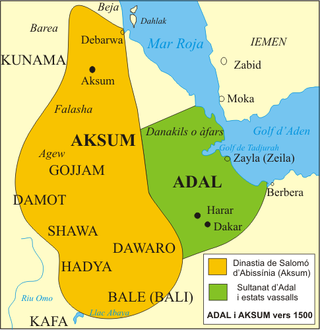
French Somaliland was a French colony in the Horn of Africa. It existed between 1884 and 1967, at which time it became the French Territory of the Afars and the Issas, after the French empowered the Issa and Afars at the expense of the Gadabuursi and Arabs. The Republic of Djibouti is its legal successor state.

<span class="mw-page-title-main">Zeila</span> Town in Awdal, Somaliland

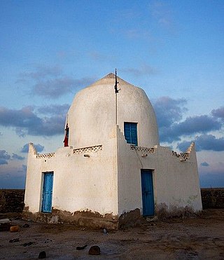
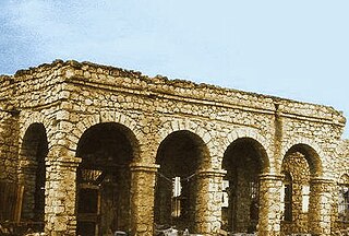
Zeila, also known as Zaila or Zayla, is a historical port town in the western Awdal region of Somaliland.

The Dir is one of the largest and most prominent Somali clans in the Horn of Africa. They are also considered to be the oldest Somali stock to have inhabited the region. Its members inhabit Djibouti, Somalia, Ethiopia, and northeastern Kenya.

<span class="mw-page-title-main">Gadabuursi</span> Northern Somali clan

The Gadabuursi, also known as Samaroon, is a northern Somali clan, a sub-division of the Dir clan family.

<span class="mw-page-title-main">Borama</span> City in Awdal, Somaliland

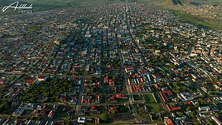
Borama is the largest city of the northwestern Awdal region of Somaliland. The commercial seat of the province, it is situated near the border with Ethiopia.

<span class="mw-page-title-main">Issa (clan)</span> Northern Somali clan

The Issa is a northern Somali clan, a sub-division of the Dir clan family.

<span class="mw-page-title-main">Lughaya</span> Town in Awdal, Somaliland

Lughaya is a coastal town in the northwestern Awdal region of Somaliland.

The Habr Awal, also contemporarily known as the Subeer Awal, and alternately romanized as the Zubeyr Awal is a major Northern Somali clan of the wider Isaaq clan family, and is further divided into eight sub-clans of whom the two largest and most prominent are the Issa Musa and Sa'ad Musa sub-clans. Its members form a part of the Habar Magadle confederation.

<span class="mw-page-title-main">Awbare</span> Town in Somali Region, Ethiopia

Awbare, officially known as Teferi Ber and called after its patron Saint Awbare, is a town in eastern Ethiopia located in the Fafan Zone of the Somali Region, near the border with Somaliland on the main trade route between Jijiga and the sea. It is the administrative centre of the Awbare district.

Metehara is a town in central Ethiopia. Located in the East Shewa Zone of the Oromia Region, it has a latitude and longitude of 08°54′N39°55′E with an elevation of 947 meters above sea level.

<span class="mw-page-title-main">Borama District</span> District in Awdal, Somaliland

Borama District is a district of the Awdal region in Somaliland.

<span class="mw-page-title-main">Lughaya District</span> District in Awdal, Somaliland

Lughaya District is a district of the Awdal region in Somaliland. Lughaya District has a total population of 101,104 residents.

<span class="mw-page-title-main">Gerisa, Awdal</span> Town in Awdal, Somaliland

Gerisa is a town in the northwestern Awdal region of Somaliland.

<span class="mw-page-title-main">Harirad</span> Town in Awdal, Somaliland

Harirad is a town in the northwestern Awdal region of Somaliland. It is about 87 km northwest of Borama and 3 km (2 mi) north of the border with Ethiopia. With an elevation of 972 meters above sea level, the settlement sprawls on a wide basin surrounded by granite mountains on all sides.

Asha Addo is a town located in Awdal, Somaliland.

The Gurgura, Gorgorah or Gurgure is a northern Somali clan, a sub-division of the Dir clan family.

The Issa Musa or ‘Isa Musa is a northern Somali clan. Its clan of the wider Isaaq clan family. The Issa Musa are divided into four major sub-clans: Mohammed Issa, Adam Issa, Abokor Issa and Idarais Issa. The Isa Musa traditionally consists of coastal people, nomadic pastoralist and merchants. This clan are primarily settled in Somaliland, including Maroodi Jeex, Togdheer, Sahil,Awdal,Djibouti Ethiopia, as well as Kenya. The Issa Musse have produced many prominent Somali figures with the Undersecretary General of the United Nations Abdulrahim Abby Farah, the first Somali Prime Minister & second President of Somaliland Muhammad Haji Ibrahim Egal, and the second tallest man in the world Hussein Bisad.

<span class="mw-page-title-main">Gadabuursi Ughazate</span> 1575 to 1884 Northern Somali kingdom

The Gadabuursi Ughazate or Ugasate evolved from and was a successor kingdom to the Adal Sultanate and Sultanate of Harar. The first Ughaz (Ugaas) of this successor kingdom, Ali Makail Dera was the son of Makail Dera, the progenitor of the Makayl-Dheere. During the late 19th century, as the region became subject to colonial rule, the Ughaz assumed a more traditional and ceremonial leadership of the clan. The Gadabuursi give their King the title of Ughaz. It's an authentic Somali term for King or Sultan. The Gadabuursi in particular are one of the clans with a long tradition of the institution of Sultan.

References

  1. "Regions, districts, and their populations: Somalia 2005 (draft)" (PDF). United Nations Office for the Coordination of Humanitarian Affairs . United Nations Development Programme. Archived from the original (PDF) on 28 July 2017. Retrieved 31 December 2020.
  2. "Country Facts | Somalia".
  3. Districts of Somalia, Statoids
  4. Glawion, Tim (2020-01-30). The Security Arena in Africa: Local Order-Making in the Central African Republic, Somaliland, and South Sudan. Cambridge University Press. ISBN   978-1-108-65983-3. Three distinct circles can be distinguished based on the way the security arena is composed in and around Zeila: first, Zeila town, the administrative centre, which is home to many government institutions and where the mostly ethnic Gadabuursi/Samaron inhabitants engage in trading or government service activities; second, Tokhoshi, an artisanal salt mining area eight kilometres west of Zeila, where a mixture of clan and state institutions provide security and two large ethnic groups (Ciise and Gadabuursi/Samaron) live alongside one another; third the southern rural areas, which are almost universally inhabited by the Ciise clan, with its long, rigid culture of self-rule.
  5. Reclus, Elisée (1886). The Earth and its Inhabitants The Universal Geography Vol. X. North-east Africa (PDF). J.S. Virtue & Co, Limited, 294 City Road. Two routes, often blocked by the inroads of plundering hordes, lead from Harrar to Zeila. One crosses a ridge to the north of the town, thence redescending into the basin of the Awash by the Galdessa Pass and valley, and from this point running towards the sea through Issa territory, which is crossed by a chain of trachytic rocks trending southwards. The other and more direct but more rugged route ascends north-eastwards towards the Darmi Pass, crossing the country of the Gadibursis or Gudabursis. The town of Zeila lies south of a small archipelago of islets and reefs on a point of the coast where it is hemmed in by the Gadibursi tribe. It has two ports, one frequented by boats but impracticable for ships, whilst the other, not far south of the town, although very narrow, is from 26 to 33 feet deep, and affords safe shelter to large craft.
  6. Samatar, Abdi I. (2001) "Somali Reconstruction and Local Initiative: Amoud University," Bildhaan: An International Journal of Somali Studies: Vol. 1, Article 9 , p. 132.
  7. Battera, Federico (2005). "Chapter 9: The Collapse of the State and the Resurgence of Customary Law in Northern Somalia". Shattering Tradition: Custom, Law and the Individual in the Muslim Mediterranean. Walter Dostal, Wolfgang Kraus (ed.). London: I.B. Taurus. p. 296. ISBN   978-1-85043-634-8 . Retrieved 18 March 2010. Awdal is mainly inhabited by the Gadabuursi confederation of clans.
  8. Renders, Marleen; Terlinden, Ulf (13 October 2011). "Chapter 9: Negotiating Statehood in a Hybrid Political Order: The Case of Somaliland". In Tobias Hagmann; Didier Péclard (eds.). Negotiating Statehood: Dynamics of Power and Domination in Africa. p. 191. ISBN   9781444395563 . Retrieved 21 January 2012.
  9. Glawion, Tim (2020-01-30). The Security Arena in Africa: Local Order-Making in the Central African Republic, Somaliland, and South Sudan. Cambridge University Press. ISBN   978-1-108-65983-3. Three distinct circles can be distinguished based on the way the security arena is composed in and around Zeila: first, Zeila town, the administrative centre, which is home to many government institutions and where the mostly ethnic Gadabuursi/Samaron inhabitants engage in trading or government service activities; second, Tokhoshi, an artisanal salt mining area eight kilometres west of Zeila, where a mixture of clan and state institutions provide security and two large ethnic groups (Ciise and Gadabuursi/Samaron) live alongside one another; third the southern rural areas, which are almost universally inhabited by the Ciise clan, with its long, rigid culture of self-rule.
  10. Reclus, Elisée (1886). The Earth and its Inhabitants The Universal Geography Vol. X. North-east Africa (PDF). J.S. Virtue & Co, Limited, 294 City Road. Two routes, often blocked by the inroads of plundering hordes, lead from Harrar to Zeila. One crosses a ridge to the north of the town, thence redescending into the basin of the Awash by the Galdessa Pass and valley, and from this point running towards the sea through Issa territory, which is crossed by a chain of trachytic rocks trending southwards. The other and more direct but more rugged route ascends north-eastwards towards the Darmi Pass, crossing the country of the Gadibursis or Gudabursis. The town of Zeila lies south of a small archipelago of islets and reefs on a point of the coast where it is hemmed in by the Gadibursi tribe. It has two ports, one frequented by boats but impracticable for ships, whilst the other, not far south of the town, although very narrow, is from 26 to 33 feet deep, and affords safe shelter to large craft.