100 Mile House

Last updated

100 Mile House
District municipality
District of 100 Mile House [1]
Town of 100 Mile House from the N (7959692224).jpg
View of 100 Mile House
Motto: 
Centum Salutationes
Canada British Columbia location map 2.svg
Red pog.svg
100 Mile House
Location of 100 Mile House in British Columbia
Canada location map 2.svg
Red pog.svg
100 Mile House
100 Mile House (Canada)
Coordinates: 51°38′34″N121°17′44″W / 51.64278°N 121.29556°W / 51.64278; -121.29556 [2]
CountryCanada
Province British Columbia
Regional district Cariboo
Founded1862
Incorporated1965
Government
  MayorMaureen Pinkney
   MP Frank Caputo (Conservative)
   MLA Lorne Doerkson (Liberal)
Area
 (2021) [4]
  Total53.01 km2 (20.47 sq mi)
Elevation
 at the weather station [5]
1,059.2 m (3,475.1 ft)
Population
 (2021) [4]
  Total1,928
  Density36.4/km2 (94/sq mi)
Time zone UTC−08:00 (PST)
Area code 250 / 778 / 236
HighwaysBC-97.svg Hwy 97
Waterways Bridge Creek
Website www.100milehouse.com OOjs UI icon edit-ltr-progressive.svg

100 Mile House is a district municipality located in the South Cariboo region of central British Columbia, Canada. [6]

Contents

History

100 Mile House was originally known as Bridge Creek House, named after the creek running through the area. Its origins as a settlement go back to the time when Thomas Miller owned a collection of ramshackle buildings serving the traffic of the gold rush as a resting point for travellers moving between Kamloops and Fort Alexandria, which was 158 kilometres (98 mi) north of 100 Mile House farther along the Hudson's Bay Brigade Trail. It acquired its current name during the Cariboo Gold Rush where a roadhouse was constructed in 1862 at the 100 miles (160 km) mark up the Old Cariboo Road from Lillooet. [7] :198

In 1930, Lord Martin Cecil left England to come to 100 Mile House and manage the estate owned by his father, the 5th Marquess of Exeter. The estate's train stop on the Pacific Great Eastern (now BC Rail leased and operated by Canadian National) railway is to the west of town and called Exeter. [8] The town, which at the time consisted of the roadhouse, a general store, a post office, telegraph office, and a power plant, had a population of 12. The original roadhouse burned down in 1937.

100 Mile House is on Secwepemc unceded territory. The nearest Secwepemc band is the Tsq'escen for which a geographic reference point is the Canim Lake Reserve.

Demographics

In the 2021 Canadian census conducted by Statistics Canada, 100 Mile House had a population of 1,928 living in 907 of its 974 total private dwellings, a change of

Religion

According to the 2021 census, religious groups in 100 Mile House included: [9]

Economy

100 Mile House's welcome sign 100Mileswelcomesign.JPG
100 Mile House's welcome sign

At present, 100 Mile House is the primary service centre for the South Cariboo and has a population of approximately 2,000. The service area has a population roughly ten times the size of the town. It includes the communities of Lac la Hache, Forest Grove, Lone Butte, Horse Lake, Bridge Lake, 70 Mile House, Canim Lake, and 108 Mile Ranch, and is the largest residential centre between Kamloops and Williams Lake.

The primary industries of 100 Mile House are forestry and ranching. Log home building and tourism are also an important part of the community.

Tourism

100 Mile House is a centre for outdoor activities and is becoming increasingly known for its richness of bird life. The surrounding area features hundreds of lakes for boating and fishing including 101 Mile Lake, 103 Mile Lake, Lac La Hache, Canim Lake, Horse Lake, Green Lake, Bridge Lake and Sheridan Lake. The Cariboo ski marathon attracts a large and international field of cross-country (Nordic) skiers.

The surrounding communities have various activities for residents and visiting tourists, including rodeos and an extensive trail system. This area is known for outdoor activities including hiking, snowmobiling, cross country skiing, and ATV riding. There are government campgrounds at Green Lake, Bridge Lake and Lac La Hache. There are also many private campsites around the area that also offer cabin and fishing boat rentals and RV hook-ups.

Transportation

100 Mile House was located historically along the Cariboo Road. Until 2002, it was served by BC Rail's daily dayliner service between Vancouver and Prince George. Until 2013, 100 Mile House was served by Greyhound Canada. Today, the town is served by the 100 Mile House Regional Transit System and by Adventure Charters intercity bus service four times a week in each direction. The area is also served by BC Transit Health Connections. The town is home to the 100 Mile House Airport with no scheduled services and is located near the larger South Cariboo Regional Airport.

Locations

Climate

100 Mile House has a humid continental climate (Köppen Dfb) with mild summers combined with cool nights, along with cold, but not very cold winters for its latitude. In spite of the moderation that comes from its relative proximity to the Pacific Ocean, extreme winter temperatures can occasionally occur, with a record low of −48 °C (−54 °F). 100 Mile House is located in a rain shadow of the coastal mountains, resulting in reduced precipitation, much of it falling as snow.

Climate data for 100 Mile House
Climate ID: 1165791; coordinates 51°38′49″N121°18′09″W / 51.64694°N 121.30250°W / 51.64694; -121.30250 (100 Mile House) ; elevation: 1,059.2 m (3,475 ft); 1981-2010 normals
MonthJanFebMarAprMayJunJulAugSepOctNovDecYear
Record high °C (°F)12.0
(53.6)
13.5
(56.3)
21.0
(69.8)
30.0
(86.0)
34.5
(94.1)
40.0
(104.0)
35.5
(95.9)
36.0
(96.8)
36.0
(96.8)
29.0
(84.2)
18.3
(64.9)
12.5
(54.5)
40.0
(104.0)
Mean daily maximum °C (°F)−2.1
(28.2)
2.1
(35.8)
7.4
(45.3)
12.2
(54.0)
17.0
(62.6)
20.3
(68.5)
23.1
(73.6)
23.3
(73.9)
18.5
(65.3)
11.1
(52.0)
2.4
(36.3)
−2.9
(26.8)
11.0
(51.8)
Daily mean °C (°F)−7.2
(19.0)
−3.7
(25.3)
0.8
(33.4)
5.2
(41.4)
9.5
(49.1)
13.0
(55.4)
15.3
(59.5)
14.9
(58.8)
10.4
(50.7)
4.8
(40.6)
−2.1
(28.2)
−7.7
(18.1)
4.4
(39.9)
Mean daily minimum °C (°F)−12.3
(9.9)
−9.4
(15.1)
−5.9
(21.4)
−1.9
(28.6)
2.0
(35.6)
5.7
(42.3)
7.4
(45.3)
6.3
(43.3)
2.2
(36.0)
−1.6
(29.1)
−6.5
(20.3)
−12.5
(9.5)
−2.2
(28.0)
Record low °C (°F)−44.5
(−48.1)
−40.5
(−40.9)
−37.8
(−36.0)
−15.0
(5.0)
−9.0
(15.8)
−4.0
(24.8)
−1.5
(29.3)
−6.0
(21.2)
−10.0
(14.0)
−32.0
(−25.6)
−40.5
(−40.9)
−48.0
(−54.4)
−48.0
(−54.4)
Average precipitation mm (inches)35.1
(1.38)
21.3
(0.84)
16.5
(0.65)
29.2
(1.15)
42.9
(1.69)
56.6
(2.23)
68.2
(2.69)
47.5
(1.87)
37.0
(1.46)
32.3
(1.27)
42.4
(1.67)
48.2
(1.90)
477.1
(18.78)
Average rainfall mm (inches)3.0
(0.12)
2.5
(0.10)
5.0
(0.20)
20.4
(0.80)
41.9
(1.65)
56.4
(2.22)
68.2
(2.69)
47.5
(1.87)
36.3
(1.43)
26.8
(1.06)
14.0
(0.55)
1.4
(0.06)
323.4
(12.73)
Average snowfall cm (inches)32.1
(12.6)
18.8
(7.4)
11.5
(4.5)
8.8
(3.5)
1.0
(0.4)
0.1
(0.0)
0.0
(0.0)
0.0
(0.0)
0.7
(0.3)
5.5
(2.2)
28.5
(11.2)
46.8
(18.4)
153.7
(60.5)
Average precipitation days (≥ 0.2 mm)9.47.26.78.611.913.013.010.58.79.511.110.4120.0
Average rainy days (≥ 0.2 mm)1.31.12.66.411.613.013.010.58.58.24.20.781.0
Average snowy days (≥ 0.2 cm)8.76.24.23.00.70.10.00.00.42.08.010.243.4
Source: Environment and Climate Change Canada [5] [10]

Sports

100 Mile House is home to the 100 Mile House Wranglers who play hockey in the Kootenay International Junior Hockey League. They are a junior 'A' team and play their home games at the South Cariboo Rec Centre.

See also

Related Research Articles

<span class="mw-page-title-main">Lillooet</span> District municipality in British Columbia, Canada

Lillooet is a district municipality in the Squamish-Lillooet region of southwestern British Columbia. The town is on the west shore of the Fraser River immediately north of the Seton River mouth. On BC Highway 99, the locality is by road about 100 kilometres (62 mi) northeast of Pemberton, 64 kilometres (40 mi) northwest of Lytton, and 172 kilometres (107 mi) west of Kamloops.

<span class="mw-page-title-main">Kamloops</span> City in British Columbia, Canada

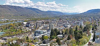
Kamloops is a city in south-central British Columbia, Canada, at the confluence of the North and South Thompson Rivers, which join to become the Thompson River in Kamloops, and east of Kamloops Lake. It is located in the Thompson-Nicola Regional District, whose district offices are based here. The surrounding region is sometimes referred to as the Thompson Country.

<span class="mw-page-title-main">Cariboo</span> Region of British Columbia, Canada

The Cariboo is an intermontane region of British Columbia, Canada, centered on a plateau stretching from Fraser Canyon to the Cariboo Mountains. The name is a reference to the caribou that were once abundant in the region.

<span class="mw-page-title-main">Williams Lake, British Columbia</span> City in British Columbia, Canada

Williams Lake is a city in the Central Interior of British Columbia, in the central part of a region known as the Cariboo. Williams Lake is one of the largest cites, by population of metropolitan area, in the Cariboo after neighbouring Quesnel. The city is famous for the Williams Lake Stampede, which was once the second largest professional rodeo in Canada, after only the Calgary Stampede.

<span class="mw-page-title-main">Cariboo Regional District</span> Regional district in British Columbia, Canada

The Cariboo Regional District spans the Cities and Districts of Quesnel, Williams Lake, 100 Mile House, and Wells in the Central Interior of British Columbia.

<span class="mw-page-title-main">Canim Beach Provincial Park</span> Provincial park in British Columbia, Canada

Canim Beach Provincial Park is a provincial park in British Columbia, Canada, located at the southwest end of Canim Lake in the Interlakes District of the South Cariboo region, adjacent to the Secwepemc Indian reserve community of Canim Lake, British Columbia just northeast of 100 Mile House. The park was established by Order-in-Council in 1956 and expanded by later legislation in 2000 and 2004 to total a current approximate of 8.2 hectares, 3.6 hectares of upland and 4.6 hectares of foreshore.

Wells is a small mining and tourist town in the Cariboo District of central British Columbia, located on BC Highway 26, 74 km (46 mi) from Quesnel and 8 km (5 mi) before the highway's terminus at Barkerville. It gains much of its revenue and jobs from tourists who pass through on their way to the Bowron Lake Provincial Park and to the historic museum town of Barkerville.

<span class="mw-page-title-main">Secwépemc</span> First Nations people in Canada

The Secwépemc, known in English as the Shuswap people, are a First Nations people residing in the interior of the Canadian province of British Columbia. They speak one of the Salishan languages, known as Secwepemc or Shuswap.

<span class="mw-page-title-main">Clinton, British Columbia</span> Village in British Columbia, Canada

Clinton is a village in British Columbia, Canada, located approximately 40 km (25 mi) northwest of Cache Creek and 30 km south of 70 Mile House.

<span class="mw-page-title-main">Spences Bridge</span> Community in British Columbia, Canada

Spences Bridge is a community in the Canadian province of British Columbia, situated 35 km (22 mi) north east of Lytton and 44 km (27 mi) south of Ashcroft. At Spences Bridge the Trans-Canada Highway crosses the Thompson River. In 1892, Spences Bridge's population included 32 people of European ancestry and 130 First Nations people. There were five general stores, three hotels, one Church of England and one school. The principal industries are fruit growing and farming. The population as of the 2021 Canadian census was 76, a decrease of 23.2 per cent from the 2016 count of 99.

<span class="mw-page-title-main">British Columbia Interior</span> Interior region of British Columbia, Canada

The British Columbia Interior, popularly referred to as the BC Interior or simply the Interior, is a geographic region of the Canadian province of British Columbia. While the exact boundaries are variously defined, the British Columbia Interior is generally defined to include the 14 regional districts that do not have coastline along the Pacific Ocean or Salish Sea, and are not part of the Lower Mainland. Other boundaries may exclude parts of or even entire regional districts, or expand the definition to include the regional districts of Fraser Valley, Squamish–Lillooet, and Kitimat–Stikine.

<span class="mw-page-title-main">Gustavus Blin Wright</span>

Gustavus Blin Wright was a pioneer roadbuilder and entrepreneur in British Columbia, Canada. His biggest achievement was building the Old Cariboo Road to the Cariboo gold fields, from Lillooet to Fort Alexandria, but he was also a partner in a freighting firm that operated on the Douglas Road, he ran a toll bridge at Bridge River, near Lillooet, and built part of the road from Quesnel to Barkerville. He was also the original owner of the town of 70 Mile House.

Lac La Hache is a recreational and retirement community in the Cariboo region of British Columbia, Canada. Located on the shore of Lac La Hache alongside British Columbia Highway 97 near the regional centre of 100 Mile House, the community's origins date to the days of the Cariboo Gold Rush and the Cariboo Wagon Road, for which it provided an important roadhouse. Lac La Hache, or "The Lake of the Axe" as it translates to, was named, during the fur trade era, after the unfortunate incident of a French-Canadian voyageur who lost his axe head while chopping a hole in the ice. It is a town rich in history, as it sits along the Gold Rush Trail.

Australian is an unincorporated community on the east side of the Fraser River in the North Cariboo region of central British Columbia. On BC Highway 97, the locality is by road about 85 kilometres (53 mi) north of Williams Lake and 33 kilometres (21 mi) south of Quesnel.

<span class="mw-page-title-main">Interlakes</span>

The Interlakes, also known as the Interlakes District, is a geographic region of the Interior of British Columbia, Canada, located along and around the Interlakes Highway between 100 Mile House on BC Highway 97 and Little Fort on the North Thompson River. The area is a subregion of the Cariboo and includes the communities of Bridge Lake and Lac des Roches.

<span class="mw-page-title-main">Mahood Falls</span> Waterfall on the Canim River in British Columbia, Canada

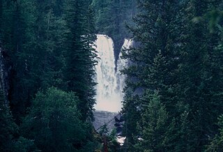
Mahood Falls is a waterfall in Wells Gray Provincial Park located on the Canim River between Canim Lake and Mahood Lake and northeast of 100 Mile House, British Columbia, Canada. The waterfall is 30 m (98 ft) high.

<span class="mw-page-title-main">Mahood Lake</span> Lake in British Columbia, Canada

Mahood Lake is a lake in the South Cariboo region of the Interior of British Columbia in Wells Gray Provincial Park. It is drained by the Mahood River, a tributary of the Clearwater River which has cut a deep canyon into Cambrian rocks and Pleistocene glacial moraines. Mahood Lake is fed by the short Canim River, which drains nearby Canim Lake to the west via Canim Falls and Mahood Falls.

Bridge Creek is a creek in the South Cariboo region of the Interior of British Columbia, Canada. Its meandering course across the Cariboo Plateau is approximately 85 kilometres in length, beginning at Bridge Lake and running roughly westwards to the town of 100 Mile House and from there turning and running northeast to Canim Lake. Below Canim Lake the Canim River connects to Mahood Lake and the short Mahood River to the Clearwater River, which meets the North Thompson at the town of Clearwater.

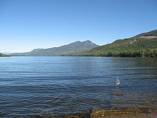
Bridge Lake is a lake in the Interlakes District of the South Cariboo region of the Interior of British Columbia, Canada. It is the source of Bridge Creek which runs in a curving course west and then northeast to Canim Lake via the town of 100 Mile House. The lake is approximately 16 km2 in area (including the area of several islands and rocks in the lake, the largest of which is named Long Island and is 1136 m in elevation. It is located 560 km north of Vancouver and around 140 km northwest of Kamloops in the Interlakes District close to the Little Fort Highway. It and its neighbours Sheridan Lake and Lac des Roches are the largest lakes along the Interlakes Highway.

105 Mile House is an unincorporated settlement in the South Cariboo region of the Central Interior of British Columbia, Canada. Located on 105 Mile Lake, it is between Lac La Hache and the town of 100 Mile House. Like other milehouse-names in this region its name is derived from its distance from Lillooet via the Old Cariboo Road.

References

  1. "British Columbia Regional Districts, Municipalities, Corporate Name, Date of Incorporation and Postal Address" (XLS). British Columbia Ministry of Communities, Sport and Cultural Development. Archived from the original on 13 July 2014. Retrieved 2 November 2014.
  2. "100 Mile House". Geographical Names Data Base . Natural Resources Canada.
  3. "100 Mile House". Geographical Names Data Base . Natural Resources Canada.
  4. 1 2 3 "Population and dwelling counts: Canada, provinces and territories, and census subdivisions (municipalities), British Columbia". Statistics Canada. 9 February 2022. Retrieved 20 February 2022.
  5. 1 2 "Canadian Climate Normals 1981-2010 Station Data". 25 September 2013. Retrieved 24 April 2022.
  6. "100 Mile House". BC Geographical Names .
  7. Akrigg, G.P.V.; Akrigg, Helen B. (1986), British Columbia Place Names (3rd, 1997 ed.), Vancouver: UBC Press, ISBN   0-7748-0636-2
  8. BC Geographical Names entry "Exeter (locality)"
  9. Government of Canada, Statistics Canada (26 October 2022). "Census Profile, 2021 Census of Population". www12.statcan.gc.ca. Retrieved 12 March 2023.
  10. Canada, Environment and Climate Change (31 October 2011). "Almanac Averages and Extremes for June 29 – Climate – Environment and Climate Change Canada". climate.weather.gc.ca. Retrieved 29 June 2021.