Abernethy, Perth and Kinross

Last updated

Abernethy
Across fields to Abernethy - geograph.org.uk - 157440.jpg
The village of Abernethy viewed from the north
Perth and Kinross UK location map.svg
Red pog.svg
Abernethy
Location within Perth and Kinross
Population1,390 (mid-2020 est.) [1]
OS grid reference NO189163
  Edinburgh 27 mi (43 km)
  London 358 mi (576 km)
Council area
Lieutenancy area
Country Scotland
Sovereign state United Kingdom
Post town PERTH
Postcode district PH2 9xx
Dialling code 01738 85
Police Scotland
Fire Scottish
Ambulance Scottish
UK Parliament
Scottish Parliament
List of places
UK
Scotland
56°19′59″N3°18′42″W / 56.33302°N 3.31163°W / 56.33302; -3.31163

Abernethy is a village and former burgh in the Perth and Kinross council area and historic county of Perthshire, in the east central Lowlands of Scotland.

Contents

Situated 8 miles (13 km) south-east of the city of Perth in the area of Strathearn, Abernethy is notable for its Pictish history and mediaeval round tower. The civil parish of Abernethy also contains the nearby settlement of Aberargie and traditionally extends to Mugdrum Island in the Firth of Tay.

History

Etymology

Abernethy, recorded in the 10th century as Aburnethige, means 'mouth of the river Nethy'. The first element of the name is the Pictish word aber 'river mouth'. The river-name Nethy is from the Celtic root nect- 'pure, clean'. [2] The Nethy Burn flows down from the Ochil Hills past the present village. The Gaelic form of the name is Obar Neithich.

Early history

There is evidence of early settlement in the area, with a Bronze Age log boat being discovered at Carpow in 2001. [3]

A group of Roman sites within the village have been given the name "the Abernethy complex", including a fortress at the top of Castle Law and the site of the former Carpow Roman Fort to the east of the village. [4]

Middle Ages

The village was once the "capital" (or at least a major religious and political centre) of the kingdom of the Picts. [5] The parish church, which sits on land given by Nechtan, a king of the Picts, is dedicated to Saint Brigid of Kildare of (fl. 451–525), and the church is said to have been founded by Dairlugdach, second abbess of Kildare, one of early Christian Ireland's major monasteries.

Several pieces of Pictish or early medieval sculpture have been found in Abernethy, including an incomplete Pictish symbol stone attached to the base of the round tower. The location "Afarnach's Hall" referred to in the earliest mediaeval Arthurian literature is usually identified as Abernethy.

Abernethy is believed to have been the seat of an early Pictish bishopric, its diocese extending westward along Strathearn. In the 12th century the bishop's seat was moved to Muthill, then Dunblane, so that Abernethy, no longer being a residential bishopric is today listed by the Catholic Church as a titular see. [6] [7]

In 1072, Abernethy was the site of the Treaty of Abernethy concluded between William the Conqueror and Malcolm III of Scotland.

Abernethy remained the site of a small priory of Augustinian canons, founded 1272. In the 15th century, this priory was suppressed in favour of a collegiate church under the patronage of the Douglas Earls of Angus. Remains of the collegiate church survived until 1802 within the present village graveyard, when they were replaced by the present plain red sandstone church, which is still dedicated to Saint Brigid. [6]

Modern history

Abernethy was granted a charter as a burgh of barony in 1476 by the 5th Earl of Angus, a status confirmed in 1628 by the 11th Earl. The Earl of Angus and Lord Abernethy have become subsidiary titles of the Dukes of Hamilton. It later became a police burgh and held its burgh status and instruments of local government until the Local Government (Scotland) Act 1973. [8]

In the Second World War, the village hosted a camp for Polish forces and was the destination for a number of evacuees. [9] In 2012, the London Olympics torch relay passed through Abernethy as part of its progress around the British Isles. [10]

Culture and community

Kirk of St Bride, the parish church St Brides Abernethy.jpg
Kirk of St Bride, the parish church

Abernethy was formerly associated with agriculture, including soft fruit production, salmon fishing and weaving. [11]

A general store is found in the village's Main Street. The local post office was replaced in 2009 with a mobile service. The village also hosts a public house, museum, garden centre, public park and heritage gardens.

A Gala / Fete Day is held annually on the first or second Saturday in June, with a race to the top of nearby Castle Law taking place the following day.

Museum of Abernethy

The Museum of Abernethy Museum of Abernethy.jpg
The Museum of Abernethy

The Museum of Abernethy in the village opened in May 2000 and is open to the public during May to September each year. It also holds a key to the round tower. [12] [13]

Religion

The village falls within the Church of Scotland's ecclesiastical parish of Abernethy, Dron and Arngask. The village's parish church is known as the Kirk of St Bride and dates to the 19th century, built on the site of a former mediaeval church and on the site of the former monastery.

The former South United Free Church building, constructed in 1866, remains in the village, but has been deconsecrated. [14]

Landmarks

Abernethy mercat cross and round tower Abernethy Cross and Tower.jpg
Abernethy mercat cross and round tower

The core of Abernethy is designated as a conservation area, with a number of residential and business premises being listed buildings.

Abernethy Round Tower

The village has one of Scotland's two surviving Irish-style round towers (the other is at Brechin, Angus); both are in the care of Historic Environment Scotland. The tower stands 74 ft (23 m) high, and it is possible to climb to the top, using a modern metal spiral staircase (the tower originally had several wooden floors linked by ladders). The tower was evidently built in two stages (shown by a change in the masonry), and probably dates from the 11th to early 12th centuries. [15]

Abernethy cross

The village's war memorial is modelled on a former market cross and was unveiled in the village's open square in 1921. [16]

Balvaird Castle

The 15th century Balvaird Castle, a mediaeval tower house, is located outside of the village.

Transport

The village is located near the M90 motorway, sitting on the A913 road, connecting to Cupar to the east and onward through the A912 to Perth in the west. There is a bus service to nearby towns. [17]

Abernethy railway station served the village until 1955, when it was closed by the British Transport Commission.[ citation needed ]

Education

The village maintains a single non-denominational state primary school. Abernethy Primary School's current building was constructed in 2002 and expanded in 2013. In 2023, the school roll was 148 pupils. [18]

Related Research Articles

<span class="mw-page-title-main">Angus, Scotland</span> Council area of Scotland

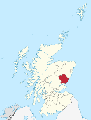
Angus is one of the 32 local government council areas of Scotland, a registration county and a lieutenancy area. The council area borders Aberdeenshire, Dundee City and Perth and Kinross. Main industries include agriculture and fishing. Global pharmaceuticals company GSK has a significant presence in Montrose in the east of the county.

<span class="mw-page-title-main">Perthshire</span> Historic administrative division in Scotland

Perthshire, officially the County of Perth, is a historic county and registration county in central Scotland. Geographically it extends from Strathmore in the east, to the Pass of Drumochter in the north, Rannoch Moor and Ben Lui in the west, and Aberfoyle in the south; it borders the counties of Inverness-shire and Aberdeenshire to the north, Angus to the east, Fife, Kinross-shire, Clackmannanshire, Stirlingshire and Dunbartonshire to the south and Argyllshire to the west. It was a local government county from 1890 to 1930.

<span class="mw-page-title-main">Perth, Scotland</span> City in central Scotland

Perth is a centrally located Scottish city, on the banks of the River Tay. It is the administrative centre of Perth and Kinross council area and is the historic county town of Perthshire. It had a population of about 47,430 in 2018.

<span class="mw-page-title-main">Fife</span> Council area of Scotland

Fife is a council area, historic county, registration county and lieutenancy area of Scotland. It is situated between the Firth of Tay and the Firth of Forth, with inland boundaries with Perth and Kinross and Clackmannanshire. By custom it is widely held to have been one of the major Pictish kingdoms, known as Fib, and is still commonly known as the Kingdom of Fife within Scotland. A person from Fife is known as a Fifer. In older documents the county was very occasionally known by the anglicisation Fifeshire.

<span class="mw-page-title-main">Brechin</span> Town in Angus, Scotland

Brechin is a town and former royal burgh in Angus, Scotland. Traditionally Brechin was described as a city because of its cathedral and its status as the seat of a pre-Reformation Roman Catholic diocese, but that status has not been officially recognised in the modern era.

<span class="mw-page-title-main">Stirling (council area)</span> Council area of Scotland

The Stirling council area is one of the 32 council areas of Scotland, and has a population of about 92,530. It was created in 1975 as a lower-tier district within the Central region. The district covered parts of the historic counties of Stirlingshire and Perthshire, which were abolished for local government purposes. In 1996 the Central region was abolished and Stirling Council took over all local government functions within the area.

<span class="mw-page-title-main">Blairgowrie and Rattray</span> Town in Scotland

Blairgowrie and Rattray is a twin burgh in Perth and Kinross, Scotland. Locals refer to the town as "Blair". Blairgowrie is the larger of the two former burghs which were united by an Act of Parliament in 1928 and lies on the southwest side of the River Ericht while Rattray is on the northeast side. Rattray claims to be the older and certainly Old Rattray, the area round Rattray Kirk, dates back to the 12th century. New Rattray, the area along the Boat Brae and Balmoral Road dates from 1777 when the River was spanned by the Brig o' Blair. The town lies on the north side of Strathmore at the foot of the Grampian Mountains. The west boundary is formed by the Knockie, a round grassy hill, and Craighall Gorge on the Ericht. Blairgowrie and Rattray developed over the centuries at the crossroads of several historic routes with links from the town to Perth, Coupar Angus, Alyth and Braemar. The roads to Coupar Angus and Braemar form part of General Wade's military road from Perth to Ayrshire then over the tiny bridge to the hill Fort George. The town's centrepiece is the Wellmeadow, a grassy triangle in the middle of town which hosts regular markets and outdoor entertainment.

<span class="mw-page-title-main">Alyth</span> Human settlement in Scotland

Alyth is a town in Perth and Kinross, Scotland, five miles northeast of Blairgowrie and about 17 miles northwest of Dundee. In 2016 the town had an estimated population of 2,400.

<span class="mw-page-title-main">Aberargie</span> Human settlement in Scotland

Aberargie is a village in the south eastern region of Perth and Kinross. It lies on the western edge of the old Abernethy Parish on the banks of the River Farg, from which it derives its name. Aberargie is around 2.5 kilometres west of Abernethy, and 3.5 kilometres southeast of Bridge of Earn.

Perth and East Perthshire was a county constituency of the House of Commons of the Parliament of the United Kingdom from 1950 to 1983. It elected one Member of Parliament (MP) by the first past the post system of election.

<span class="mw-page-title-main">Elcho Castle</span> Castle in Perth and Kinross, Scotland, UK

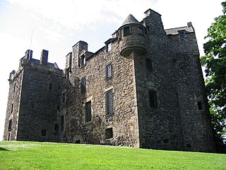
Elcho Castle is located close to the south bank of the River Tay approximately four miles south-east of Perth, Scotland, in the region of Perth and Kinross. It was maintained by Clan Wemyss from its construction around 1560 until it was put into the care of the Secretary of State for Scotland in the early 20th century, though was not occupied for the entire time. In around 1830 it was re-roofed and a nearby cottage constructed. The castle has been a scheduled monument since 1920 on the grounds of being "a particularly fine example of a Medieval tower-house", and the cottage became a listed building in 1971 in recognition of its national importance. The castle is unusual in that it has both en suite guest accommodation like a mansion, but also a large number of gun loops.

<span class="mw-page-title-main">Meigle</span> Human settlement in Scotland

Meigle is a village in Strathmore, Scotland. It lies in the council area of Perth and Kinross in the Coupar Angus and Meigle ward. It lies on the A94 road between Perth and Forfar.The A94 used to be the main route between Aberdeen and Perth. Other smaller settlements nearby are Balkeerie, Kirkinch and Kinloch. Meigle is accessed from the north and south via the B954 road. In 1971 it had a population of 357.

<span class="mw-page-title-main">Abernethy and Kincardine</span> Human settlement in Scotland

Abernethy and Kincardine is a civil parish, and former registration district and ecclesiastical parish, in the Highland council area of Scotland. The name is not in use for any modern administrative entity, but remains as the usual description for historical purposes, in the case of the registration district being only a name change.

<span class="mw-page-title-main">Muthill</span> Village in Scotland

Muthill, pronounced, is a village in Perth and Kinross, Perthshire, Scotland. The name derives from Scottish Gaelic Maothail meaning “soft-ground”.

Abernethy may refer to:

<span class="mw-page-title-main">Gowrie</span> Region in central Scotland

Gowrie is a region in central Scotland and one of the original provinces of the Kingdom of Alba. It covered the eastern part of what became Perthshire. It was located to the immediate east of Atholl, and originally included the area around Perth, though that was later detached as Perthia.

Perth is a city and former royal burgh in central Scotland. There has been a settlement at Perth since prehistoric times. Finds in and around Perth show that it was occupied by the Mesolithic hunter-gatherers who arrived in the area more than 8,000 years ago. Nearby Neolithic standing stones and circles followed the introduction of farming from about 4000 BC, and a remarkably well preserved Bronze Age log boat dated to around 1000 BC was found in the mudflats of the River Tay at Carpow to the east of Perth. Carpow was also the site of a Roman legionary fortress.

<span class="mw-page-title-main">Carpow</span> Human settlement in Scotland

Carpow is a diffuse hamlet in Perth and Kinross, Scotland. It is situated immediately to the east of the confluence of the River Tay and River Earn, 2 km north east of Abernethy.

<span class="mw-page-title-main">Crieff Town Hall</span> Municipal building in Kirkwall, Scotland

Crieff Town Hall is a municipal building in the High Street, Crieff, Perth and Kinross, Scotland. The structure, which is currently used as a tourist information centre and museum, is a Category B listed building.

<span class="mw-page-title-main">School Wynd</span> Street in Abernethy, Scotland

School Wynd is a street and open space in the centre of Abernethy, Perth and Kinross, Scotland. Running between Main Street in the south and Back Dykes in the north, it is the site of Abernethy Round Tower, a scheduled monument dating to the 18th century. The street is named for the school which formerly operated on it, a building now occupied by Abernethy Museum.

References

  1. "Mid-2020 Population Estimates for Settlements and Localities in Scotland". National Records of Scotland. 31 March 2022. Retrieved 31 March 2022.
  2. Grant, Alison (2010). Macleod, Iseabail (ed.). The Pocket Guide to Scottish Place-Names. Glasgow: Richard Drew Ltd. p. 24. ISBN   978-1-899471-00-3. OCLC   759569647.
  3. "Home - Perth and Kinross Heritage Trust". 21 May 2021. Retrieved 11 April 2024.
  4. "Castle Law, Abernethy | Canmore". canmore.org.uk. Retrieved 11 April 2024.
  5. Abernethy Archived 13 October 2009 at the Wayback Machine at the Museum of Abernethy
  6. 1 2 Annuario Pontificio 2013 (Libreria Editrice Vaticana 2013 ISBN   978-88-209-9070-1), p. 821
  7. "Titular See of Abernethy, Scotland". GCatholic. Retrieved 19 February 2021.
  8. "Abernethy from The Gazetteer for Scotland". www.scottish-places.info. Retrieved 7 May 2024.
  9. "Museum of Abernethy | Abernethy | Scotland | War". www.museumofabernethy.co.uk. Retrieved 7 May 2024.
  10. "Olympic Torch Relay live: Day 25 – Aberdeen to Dundee". 7 May 2024. ISSN   0140-0460 . Retrieved 7 May 2024.
  11. "Museum of Abernethy | Abernethy | Scotland | Work Commerce". www.museumofabernethy.co.uk. Retrieved 11 April 2024.
  12. "Bespoke Software Solutions | Responsive Web Design | Perth | Scotland | Perthshire | Fife | Stirling | Dunblane | Angus". bespoke-software-solutions.co.uk. Retrieved 11 April 2024.
  13. "index". www.museumofabernethy.co.uk. Retrieved 19 April 2018.
  14. "KIRK WYND, FORMER SOUTH UNITED FREE CHURCH (THE WILLIAMSON KIRK) (LB20919)". portal.historicenvironment.scot. Retrieved 7 May 2024.
  15. "Abernethy Round Tower and Pictish symbol stone (SM90005)". portal.historicenvironment.scot. Retrieved 11 April 2024.
  16. "Abernethy (near Perth)- Cross". Imperial War Museums. Retrieved 11 April 2024.
  17. "Perth & Kinross Council - Kinross-shire and Bridge of Earn area timetables". www.pkc.gov.uk. Retrieved 19 April 2018.
  18. "Abernethy Primary School - School Handbook Academic Session 2024-2025" (PDF). Retrieved 7 May 2024.

Notes

1. ^ The foundation of Abernethy is to be found in the Pictish Chronicle and links it to Nechtan Morbet. However, it may have been Nechtan nepos Uerb, and the later Nechtan mac Der-Ilei may have been confused with the previous two.