
Perthshire, officially the County of Perth, is a historic county and registration county in central Scotland. Geographically it extends from Strathmore in the east, to the Pass of Drumochter in the north, Rannoch Moor and Ben Lui in the west, and Aberfoyle in the south; it borders the counties of Inverness-shire and Aberdeenshire to the north, Angus to the east, Fife, Kinross-shire, Clackmannanshire, Stirlingshire and Dunbartonshire to the south and Argyllshire to the west. It was a local government county from 1890 to 1930.

Perth and Kinross is one of the 32 council areas of Scotland and a Lieutenancy Area. It borders onto the Aberdeenshire, Angus, Argyll and Bute, Clackmannanshire, Dundee, Fife, Highland and Stirling council areas. Perth is the administrative centre. With the exception of a large area of south-western Perthshire, the council area mostly corresponds to the historic counties of Perthshire and Kinross-shire.

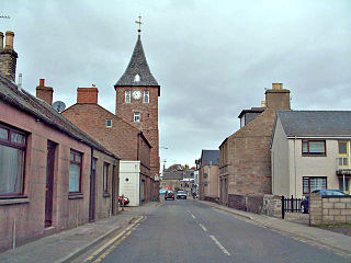
Blairgowrie and Rattray is a twin burgh in Perth and Kinross, Scotland. Locals refer to the town as "Blair". Blairgowrie is the larger of the two former burghs which were united by an Act of Parliament in 1928 and lies on the southwest side of the River Ericht while Rattray is on the northeast side. Rattray claims to be the older and certainly Old Rattray, the area round Rattray Kirk, dates back to the 12th century. New Rattray, the area along the Boat Brae and Balmoral Road dates from 1777 when the River was spanned by the Brig o' Blair. The town lies on the north side of Strathmore at the foot of the Grampian Mountains. The west boundary is formed by the Knockie, a round grassy hill, and Craighall Gorge on the Ericht. Blairgowrie and Rattray developed over the centuries at the crossroads of several historic routes with links from the town to Perth, Coupar Angus, Alyth and Braemar. The roads to Coupar Angus and Braemar form part of General Wade's military road from Perth to Fort George. The town's centrepiece is the Wellmeadow, a grassy triangle in the middle of town which hosts regular markets and outdoor entertainment.
Coupar Angus is a town in Perth and Kinross, Scotland, 4 miles south of Blairgowrie.
Perth and East Perthshire was a county constituency of the House of Commons of the Parliament of the United Kingdom from 1950 to 1983. It elected one Member of Parliament (MP) by the first past the post system of election.

The Dundee and Newtyle Railway opened in 1831 and was the first railway in the north of Scotland. It was built to carry goods between Dundee and the fertile area known as Strathmore; this involved crossing the Sidlaw Hills, and was accomplished with three rope-worked inclined planes. Newtyle was simply a remote railhead, and the anticipated traffic volumes were not achieved, the inclines incurred heavy operating costs, and the railway never made money.

Meigle is a village in Strathmore, Scotland. It lies in the council area of Perth and Kinross in the Coupar Angus and Meigle ward. The nearest town is Forfar in neighbouring Angus. Other smaller settlements nearby are Balkeerie, Kirkinch and Kinloch. Meigle is accessed from the north and south via the B954 road. In 1971 it had a population of 357.

Burrelton is a small village in Scotland about 12 miles outside Perth and 15 miles outside Dundee. It is joined onto another smaller village, Woodside. It is 2 miles from Coupar Angus and 5 miles from Balbeggie. The population in 2001 was 621.
Coupar Angus Junior Football Club are a Scottish Junior football club based in Coupar Angus, Perth and Kinross. Their home ground is Foxhall Park.

Kinrossie is a linear village in the Perth and Kinross area of Scotland. It is less than a mile south off the A94 road, 8 miles from Perth and 6 miles from Coupar Angus.
The Scottish Midland Junction Railway was authorised in 1845 to build a line from Perth to Forfar. Other companies obtained authorisation in the same year, and together they formed a route from central Scotland to Aberdeen. The SMJR opened its main line on 4 August 1848. Proposals to merge with other railways were rejected by Parliament at first, but in 1856 the SMJR merged with the Aberdeen Railway to form the Scottish North Eastern Railway. The SNER was itself absorbed into the larger Caledonian Railway in 1866. The original SMJR main line was now a small section of a main line from Carlisle and central Scotland to Aberdeen.
Wolfhill is a village in Perthshire, Scotland, with a population of 316. Formerly known as Carolina, it was given the nickname of "Snipetown" many years ago by locals, owing to the high numbers of snipes that used to inhabit the area.
Gowrie is a region and ancient province of Scotland, covering the eastern sliver of what became Perthshire. It was located to the immediate east of Atholl, and originally included the area around Perth, though that was later detached as Perthia.

Kinloch is a small settlement along the A94 road in the Coupar Angus and Meigle ward of the council area of Perth and Kinross in eastern Scotland. Approximately 4+1⁄2 miles east is the village of Eassie, noted for the presence of the Eassie Stone; this carved Pictish stone is dated prior to the Early Middle Ages.
Coupar Angus railway station served the town of Coupar Angus, Perth and Kinross, Scotland from 1837 to 1967 on the Scottish Midland Junction Railway.
Woodside is a small village in Scotland, 12 miles from Perth, in the Perth and Kinross council area. It is joined onto another village, Burrelton. It is 2 miles from Coupar Angus, the nearest town.

Caputh is a parish and village in Perth and Kinross, Scotland. It lies on the A984 Coupar Angus to Dunkeld road about 6 miles southeast of Dunkeld and 8 miles west of Coupar Angus.
Campmuir is a small village in the Perth and Kinross area of Scotland.

Ardler is a small village in Perth and Kinross, Scotland. It is situated approximately 3 miles east of Coupar Angus, and approximately equidistant between the latter and Meigle.

