Market Drayton is a market town and civil parish on the banks of the River Tern in Shropshire, England. It is close to the Cheshire and Staffordshire borders. It is located between the towns of Whitchurch, Wem, Nantwich, Newcastle-under-Lyme, Newport and the city of Stoke on Trent. The town is on the Shropshire Union Canal and bypassed by the A53 road.

Earl of Kilmorey is a title in the Peerage of Ireland. It was created in 1822 for Francis Needham, 12th Viscount Kilmorey, a General in the British Army and former Member of Parliament for Newry. He was made Viscount Newry and Mourne, in the County of Down, at the same time, also in the Peerage of Ireland.

Woore is a village and civil parish in the north east of Shropshire, England. The population of the village as recorded in the 2011 census is 633, and for the civil parish is 1,069. The civil parish extends to about 3,950 acres.

Hodnet is a village and civil parish in Shropshire, England. The town of Market Drayton lies 5.7 miles (9.2 km) north-east of the village. In 2011 the parish had a population of 1534.

Dumbleton is a village and civil parish in the Tewkesbury district, in the county of Gloucestershire, England. The village is roughly 20 miles from the city of Gloucester. The village is known to have existed in the time of Æthelred I who granted land to Abingdon Abbey, and it is mentioned in the Domesday Book.

Cheswardine is a rural village and civil parish in north east Shropshire, England. The village lies close to the border with Staffordshire and is about 8 miles north of Newport and 5 miles south east of Market Drayton. At the 2001 Census, the parish, had a population of 991 people, increasing to 1,076 at the 2011 Census.

Brimington is a large village and civil parish in the Borough of Chesterfield in Derbyshire, England. The population of the parish taken at the 2011 census was 8,788. The town of Staveley is to the east, and Hollingwood is nearby. The parish includes Brimington Common along the Calow Road, and New Brimington, a late 19th-century extension towards the Staveley Iron Works.

Pitchford is a small village in the English county of Shropshire. It is located between Cantlop and Acton Burnell and stands on an affluent of the River Severn. Pitchford takes its name from a bituminous spring/pitch in the village, located near The Row Brook.

Sutton upon Tern is a civil parish in Shropshire, England. Expanded in 1914 after the abolition of the parish of Drayton in Hales, its name in Old English means 'South farm/settlement' on the River Tern. It lies south of Market Drayton, on the River Tern.
Robert Needham, 2nd Viscount Kilmorey was an English Royalist and supporter of Charles I during the English Civil War.

Shavington cum Gresty is a civil parish in the unitary authority of Cheshire East and the ceremonial county of Cheshire, England. It lies to the south of Crewe. It includes the large village of Shavington, which lies 2+1⁄2 miles south of Crewe, as well as the smaller settlements of Dodds Bank, Park Estate, Puseydale, Sugar Loaf and part of Goodall's Corner. Nearby villages include Basford, Hough, Willaston, Wistaston and Wybunbury. The total population of the civil parish is a little under 5,000.

Calverhall is a small village in Shropshire, approximately 5 miles away from the town of Whitchurch. It lies within the civil parish of its neighbouring village of Ightfield which is one mile away.
Drayton is a village and civil parish in the valley of the Sor Brook in Oxfordshire, about 2 miles (3 km) northwest of Banbury. The 2011 Census recorded the parish's population as 242.

Houghton is a small village and a civil parish in the English county of Norfolk. It covers an area of 7.64 km2 (2.95 sq mi) and had a population of 69 in 36 households at the 2001 census. At the 2011 census the population of the parish was again below 100, and was therefore included in the civil parish of West Rudham.

Longford is a village and former civil parish, now in the parish of Church Aston, in the Telford and Wrekin district, in the ceremonial county of Shropshire, England. It is near the town of Newport. In 1961 the parish had a population of 102. On 1 April 1988 the parish was abolished and merged with Church Aston. Roman coins and medieval artifacts have been discovered in the village and it was listed in Domesday Book in 1086 with a population of 23 households, 13.5 plough lands and a mill. The historic manor covers 1,306 acres and includes the townships of Brockton and Stockton. Sites of historic importance include: Longford Hall, a late 16th-century dovecote, Church of St Mary, 13th century Talbot Chapel, remains of a mill race and several farm buildings.

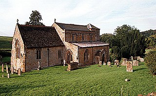
St Peter's Church is an Anglican church in the village of Adderley, Shropshire, England. It is recorded in the National Heritage List for England as a designated Grade I listed building, The church has a dual function. Its nave and tower form an active parish church in the united benefice of Adderley, Ash, Calverhall, Ightfield and Moreton Say, in the deanery of Hodnet, the archdeaconry of Salop, and the diocese of Lichfield. The chancel and transepts are under the care of The Churches Conservation Trust.
Sir John Corbet, 1st Baronet of Stoke upon Tern was an English politician who represented Shropshire in the House of Commons of the long Parliament. As a moderate Puritan, he was noted before the English Civil War for his campaigns against extra-parliamentary taxation, and for waging a long running dispute over control of his parish church at Adderley which led to his imprisonment. He was a notable member of the Shropshire county committee, responsible for pursuing the war against the royalists. As a part of a Presbyterian middle group in Parliament, he was one of those secluded from parliament by Pride's Purge, and was stripped of his remaining public offices after the Restoration.

Robert Needham, 1st Viscount Kilmorey was an English politician and a peer in the peerage of Ireland.
John Pemberton Heywood (1803–1877) was a banker from Liverpool, England, who was High Sheriff of Lancashire in 1855.
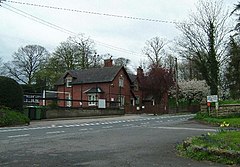
Adderley is a civil parish in Shropshire, England. It contains 26 listed buildings that are recorded in the National Heritage List for England. Of these, one is listed at Grade I, the highest of the three grades, and the others are at Grade II, the lowest grade. Apart from the village of Adderley, the parish is rural. Two country houses were demolished in the 1950s, Adderley Hall, and Shavington Hall, but a number of structures associated with them have survived and are listed, including stable blocks, farmhouses and farm buildings, and bridges. The Shropshire Union Canal passes through the parish, and a number of bridges and two mileposts associated with it are listed. The other listed buildings include a church and associated structures.