Altrincham Interchange

Last updated

Altrincham
National Rail logo.svg Metrolink generic.png
Altrincham Interchange.jpeg
Altrincham Interchange building, opened 2015
General information
Location Altrincham, Trafford
England
Coordinates 53°23′15″N2°20′50″W / 53.3875°N 2.3472°W / 53.3875; -2.3472
Grid reference SJ770879
Managed by Northern Trains
Transit authority Transport for Greater Manchester
Platforms4 (2 National Rail, 2 Metrolink)
Other information
Station codeALT
Fare zoneG
Classification DfT category C2
Key dates
20 July 1849Original MSJA railway station opens
3 April 1881MSJA station replaced on current site
6 May 1974Name changed from Altrincham and Bowdon to Altrincham
15 June 1992 Metrolink service starts
Passengers
2018/19Decrease2.svg 0.397 million
BSicon uCONTg.svg
BSicon uINT.svg
Deansgate-Castlefield
( National Rail logo.svg Deansgate)
BSicon umbKRZo +cerulean.svg
Bridgewater Canal
BSicon uBHF.svg
Cornbrook
BSicon udCONTgq.svg
BSicon uABZgr.svg
BSicon dCONTgq.svg
BSicon umKRZu.svg
BSicon dCONTfq.svg
BSicon uHST.svg
Trafford Bar
BSicon uABZgl.svg
BSicon udCONTfq.svg
BSicon uHST.svg
Old Trafford
BSicon uHST.svg
Stretford
BSicon uhbKRZWae.svg
BSicon uSKRZ-Bo.svg
BSicon uHST.svg
Dane Road
BSicon uHST.svg
Sale BSicon BICYCLE.svg
BSicon uHST.svg
Brooklands
BSicon uHST.svg
Timperley
BSicon uINT.svg
Navigation Road National Rail logo.svg
BSicon uKINTe.svg
Altrincham National Rail logo.svg BSicon BUS.svg BSicon BICYCLE.svg
Location Altrincham Interchange

There is a frequent Metrolink service to Manchester and Bury, with a tram every six minutes to Manchester for most of the day (alternate trams running to Bury, avoiding Piccadilly). Monday-Saturday evening and Sunday journeys run every 12 minutes to Piccadilly, with journeys to Bury requiring a change of trams at Piccadilly Gardens. [12]

Altrincham is in Metrolink fare zone 4. [13]

Service pattern

Preceding station Manchester metrolink logo.PNG Manchester Metrolink Following station
TerminusAltrincham–Bury Navigation Road
towards Bury
Altrincham–Piccadilly Navigation Road
towards Piccadilly
Preceding station National Rail logo.svg National Rail Following station
Hale   Northern Trains
Mid-Cheshire Line
  Navigation Road
Historical railways
Hale
Line and station open
  Cheshire Lines Committee
Mid-Cheshire Line
  Sale
Line and station open
Disused railways
Baguley   Cheshire Lines Committee
Stockport, Timperley and Altrincham Junction Railway
 Terminus

Bus services

The former station forecourt now serves as a Transport for Greater Manchester bus station, providing interchange with local bus services to locations within Trafford. Buses also operate to Stockport, Wythenshawe, Macclesfield, The Trafford Centre, Sale, Hale, Timperley, East Didsbury, Manchester Airport, Bowdon and Warrington. The main bus operator is Arriva North West but other significant operators include Stagecoach Manchester, Warrington's Own Buses, Warrington Coachways and Vale Travel. [14]

There is also a taxi rank. [15]

Related Research Articles

<span class="mw-page-title-main">Manchester Piccadilly station</span> Railway station in Manchester, England

Manchester Piccadilly is the principal railway station in Manchester, England. Opened as Store Street in 1842, it was renamed Manchester London Road in 1847 and became Manchester Piccadilly in 1960. Located to the south-east of Manchester city centre, it hosts long-distance intercity and cross-country services to national destinations including London, Birmingham, Nottingham, Glasgow, Edinburgh, Cardiff, Bristol, Exeter, Plymouth, Reading, Southampton and Bournemouth; regional services to destinations in Northern England including Liverpool, Leeds, Sheffield, Newcastle and York; and local commuter services around Greater Manchester. It is one of 19 major stations managed by Network Rail. The station has 14 platforms: 12 terminal and two through platforms. Piccadilly is also a major interchange with the Metrolink light rail system with two tram platforms in its undercroft.

<span class="mw-page-title-main">Manchester Oxford Road railway station</span> Railway station in Manchester, England

Manchester Oxford Road railway station is a railway station in Manchester, England, at the junction of Whitworth Street West and Oxford Street. It opened in 1849 and was rebuilt in 1960. It is the second busiest of the four stations in Manchester city centre.

<span class="mw-page-title-main">Timperley</span> Human settlement in England

Timperley is a suburban village in the borough of Trafford, Greater Manchester, England. Within the boundaries of the historic county of Cheshire, it is approximately six miles southwest of central Manchester. The population at the 2011 census was 11,061.

<span class="mw-page-title-main">Stockport railway station</span> Railway station in Stockport, Greater Manchester, England

Stockport railway station in Stockport, Greater Manchester, England, is 6 miles south-east of Manchester Piccadilly on the West Coast Main Line to London Euston.

<span class="mw-page-title-main">Hale railway station</span> Railway station in Greater Manchester, England

Hale railway station serves the area of Hale in the south of Altrincham, Greater Manchester, England. It is also used by people living in the surrounding areas of Bowdon and Hale Barns. The station is located on Ashley Road. It is on the Mid-Cheshire line, from Chester to Manchester Piccadilly.

<span class="mw-page-title-main">Northwich railway station</span> Railway station in Cheshire, England

Northwich railway station serves the town of Northwich in Cheshire, England. The station has two platforms and is located on the Mid-Cheshire line 28+14 miles (45.5 km) southwest of Manchester Piccadilly.

<span class="mw-page-title-main">Navigation Road station</span> Railway station in Greater Manchester, England

Navigation Road is a station that serves both Northern Trains and Manchester Metrolink located in the east of Altrincham, in Greater Manchester, England. It consists of a Northern-operated heavy rail station on the Mid-Cheshire Line, and an adjoining light rail stop on the Altrincham Line of Greater Manchester's Metrolink network. The original heavy rail element of the station was opened by the Manchester, South Junction and Altrincham Railway in 1931, and the Metrolink element opened in 1992. A level crossing operates at the southern end of the station.

<span class="mw-page-title-main">Mid-Cheshire line</span>

The Mid-Cheshire line is a railway line in the north-west of England that runs from Chester to Edgeley Junction, Stockport; it connects Chester with Manchester Piccadilly, via Knutsford. After Chester Northgate closed in 1969, the section between Mickle Trafford Junction and Chester was used for freight trains only until it closed in 1992; from Mickle Trafford, passenger trains use the Chester–Warrington line to Chester General instead. The route taken by passenger trains has changed over the years and now differs considerably from the original. Between 2001 and 2014, passenger journeys on the line increased to over 1.7 million per year. A near doubling of the passenger service was expected to occur from December 2018, however this did not materialise.

<span class="mw-page-title-main">Manchester, South Junction and Altrincham Railway</span> Suburban railway in Manchester

The Manchester South Junction and Altrincham Railway (MSJ&AR) was a suburban railway which operated an 8+12-mile (14 km) route between Altrincham in Cheshire and Manchester London Road railway station in Manchester.

<span class="mw-page-title-main">Brooklands tram stop</span> Manchester Metrolink tram stop

Brooklands is a tram stop and park and ride site on the Altrincham Line of Greater Manchester's light-rail Metrolink system in the Brooklands area of Sale. It opened on 15 June 1992 as part of Phase 1 of Metrolink's expansion.

<span class="mw-page-title-main">Sale tram stop</span> Manchester Metrolink tram stop

Sale is a tram stop on the Altrincham Line of the Metrolink light-rail system in Sale, Greater Manchester, England. It opened on 15 June 1992 as part of Phase 1 of Metrolink's expansion. Prior to this, it was a railway station on the Manchester, South Junction and Altrincham Railway (MSJAR) line. It was built by John Brogden, who was a local builder in the Sale area.

<span class="mw-page-title-main">Dane Road tram stop</span> Metrolink stop in South Manchester

Dane Road is a tram stop on the Altrincham Line of Greater Manchester's Metrolink light rail system. It is located on Dane Road in northern Sale, Greater Manchester, England. It opened on 15 June 1992 as part of Phase 1 of Metrolink's expansion.

<span class="mw-page-title-main">Stretford tram stop</span> Manchester Metrolink tram stop

Stretford is a tram stop on the Altrincham Line of Greater Manchester's light-rail Metrolink system. It is located in Stretford, on the corner of Chester Road and Edge Lane. It opened on 15 June 1992 as part of Phase 1 of Metrolink's expansion.

<span class="mw-page-title-main">Old Trafford tram stop</span> Manchester Metrolink tram stop

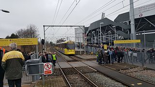
Old Trafford is a tram stop on the Altrincham Line of the Metrolink light rail system in Old Trafford, Greater Manchester, England.

<span class="mw-page-title-main">Trafford Bar tram stop</span> Manchester Metrolink tram stop

Trafford Bar is a tram stop on Greater Manchester's light rail system, Metrolink, at the junction of Talbot Road and Seymour Grove in Old Trafford. It opened on 15 June 1992 as part of Phase 1 of Metrolink's expansion, before which it was a mainline railway station.

<span class="mw-page-title-main">Cornbrook tram stop</span> Manchester Metrolink tram stop

Cornbrook tram stop is a tram stop on Greater Manchester's light rail Metrolink system in the Cornbrook area of Manchester, England. It is an interchange station, allowing passenger transfer between the network's Altrincham, Eccles, Airport, Trafford Park and South Manchester lines. The station opened on 6 December 1999 for line transfers and allowed street-level entry and exit to the public from 3 September 2005. It takes its name from Cornbrook Road, between the A56 and Pomona Docks on the Manchester Ship Canal, and was built on what was a Cheshire Lines Committee route to Manchester Central railway station. The stop is one of the most used on the Metrolink network.

<span class="mw-page-title-main">Baguley railway station</span> Disused railway station in Manchester, England

Baguley railway station was a station in the south of Manchester, England, at the extreme western edge of Baguley near the southern end of Brooklands Road where Shady Lane crossed the railway line.

<span class="mw-page-title-main">Altrincham Line</span> Manchester Metrolink line

The Altrincham Line is a tram line of the Manchester Metrolink running from Manchester to Altrincham in Greater Manchester. Originally a railway line, it was, along with the Bury Line, converted into a tramway during 1991–92, as part of the first phase of the Metrolink system.

<span class="mw-page-title-main">Proposed developments of Manchester Metrolink</span> Development of Manchester Metrolink light rail system

This is a list of confirmed or proposed future developments of the Manchester Metrolink light rail system in Greater Manchester, England.

References

  1. Slater, J.N., ed. (July 1974). "Notes and News: Stations renamed by LMR". Railway Magazine . London: IPC Transport Press Ltd. 120 (879): 363. ISSN   0033-8923.
  2. Dixon 1994, p. 119.
  3. "Altrincham Metrolink stop : Metrolink". TheTrams.co.uk. Retrieved 28 November 2018.
  4. "Station roof" Archived 16 June 2008 at the Wayback Machine , This is Trafford - Retrieved 28 November 2006
  5. Historic England. "CLOCK TOWER ON STATION FORECOURT (1067962)". National Heritage List for England .
  6. Dickens, Steven (15 August 2018). Altrincham in 50 Buildings. Amberley Publishing Limited. ISBN   978-1-4456-7459-9 . Retrieved 21 September 2021.
  7. "Archived copy" (PDF). Archived from the original (PDF) on 8 December 2014. Retrieved 8 December 2014.{{cite web}}: CS1 maint: archived copy as title (link)
  8. "Pages - Altrincham Interchange". Archived from the original on 8 December 2014. Retrieved 8 December 2014.
  9. "Confirmed: Altrincham Interchange to open on Sunday | Altrincham Today". Archived from the original on 8 December 2014. Retrieved 8 December 2014.
  10. "Altincham-layout". tfgm.com. Archived from the original on 4 March 2016. Retrieved 11 December 2016.
  11. GB National Rail Timetable 2013-14, Table 88
  12. "Metrolink - Tram Times - Altrincham". Metrolink / Transport for Greater Manchester. Retrieved 13 February 2013.
  13. "Metrolink ticket zones map". TfGM. Retrieved 5 December 2018.
  14. "Altrincham Interchange". Transport for Greater Manchester. Retrieved 21 September 2021.
  15. "Altrincham [ALT]". nationalrail.uk. Retrieved 11 December 2016.

Further reading