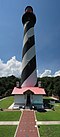
The Cape Florida Light is a lighthouse on Cape Florida at the south end of Key Biscayne in Miami-Dade County, Florida. Constructed in 1825, it guided mariners off the Florida Reef, which starts near Key Biscayne and extends southward a few miles offshore of the Florida Keys. It was operated by staff, with interruptions, until 1878, when it was replaced by the Fowey Rocks lighthouse. The lighthouse was put back into use in 1978 by the U.S. Coast Guard to mark the Florida Channel, the deepest natural channel into Biscayne Bay. They decommissioned it in 1990.

Alligator Reef Light is located 4 nautical miles east of Indian Key, near the Matecumbe Keys of Florida in the United States, north of Alligator Reef itself. The station was established in 1873. It was automated in 1963 and was last operational in July, 2014, and is being replaced by a 16' steel structure with a less powerful light located adjacent to it. The structure is an iron pile skeleton with a platform. The light is 136 feet (41 m) above the water. It is a white octagonal pyramid skeleton framework on black pile foundation, enclosing a square dwelling and a stair-cylinder. The lantern is black. The original lens was a first order bivalve Fresnel lens. The light characteristic of the original light was: flashing white and red, every third flash red, from SW by W 1/2 W through southward to NE 1/8 E, and from NE by E 3/4 E through northward to SW 3/8 S; flashing red throughout the intervening sectors; interval between flashes 5 seconds. It had a nominal range of 14 nautical miles in the white sectors and 11 nautical miles in the red sectors. The new light has a range of approximately 7 nautical miles.

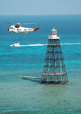
Fowey Rocks Light is located seven miles southeast of Cape Florida on Key Biscayne. The lighthouse was completed in 1878, replacing the Cape Florida Light. It was automated on May 7, 1975, and as of 2021 is still in operation. The structure is cast iron, with a screw-pile foundation, a platform and a skeletal tower. The light is 110 feet above the water. The tower framework is painted brown, while the dwelling and enclosed circular stair to the lantern is painted white. The original lens was a first-order drum Fresnel lens which stood about 12 feet (4 m) high and weighed about a ton (tonne). The light has a nominal range of 15 miles in the white sectors, and 10 miles in the red sectors.
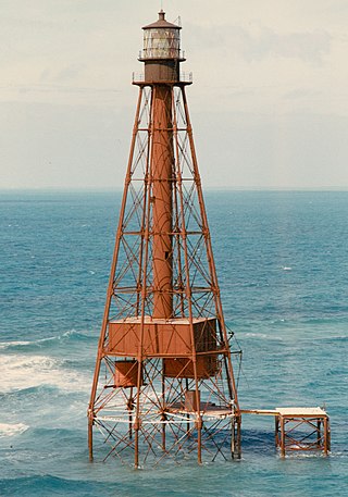
Carysfort Reef Light is located approximately six nautical miles east of Key Largo, Florida. The lighthouse has an iron screw-pile foundation with a platform, and a skeletal, octagonal, pyramidal tower, which is painted red. The light is 100 feet (30 m) above the water. It was the oldest functioning lighthouse of its type in the United States until it was decommissioned in 2015, having been completed in 1852. Carysfort Reef is named for HMS Carysfort (1766), a 20-gun Royal Navy post ship that ran aground on the reef in 1770. The light currently installed is a xenon flashtube beacon. It was added to the National Register of Historic Places in 1984.
Sombrero Key Light is located offshore of Vaca Key in Marathon, Florida. The lighthouse is located on a mostly submerged reef. The name Sombrero Key goes back to the Spanish, and old charts show a small island at the spot, but by the later 19th Century the island had eroded away, with some parts of the reef exposed at low tide. As a result, the reef and the lighthouse have also been called Dry Banks.

The Dry Tortugas Light is a lighthouse located on Loggerhead Key, three miles west of Fort Jefferson, Florida. It was taken out of operation in 2015. It has also been called the Loggerhead Lighthouse. It has been said to be "a greater distance from the mainland than any other light in the world."

The Garden Key Light, also known as the Tortuga Harbor Light, is located at Fort Jefferson, on Garden Key in the Dry Tortugas, Florida. The first lighthouse, started in 1824 and first lit in 1826, was a brick conical tower. The lighthouse and its outbuildings were the only structures on Garden Key until construction started on Fort Jefferson in 1846. Construction continued until 1861, but the fort was never completed.

The Amelia Island Light is the oldest existing lighthouse in the state of Florida in the United States. It is located near the northern end of Amelia Island in the northeastern part of the state. Its light marks St. Marys Entrance, the inlet leading to St. Marys River, the Cumberland Sound and the harbor of Fernandina Beach, Florida along the Amelia River. The white light flashes every ten seconds which turns red from 344° to 360° when covering the shoal water in the vicinity of Nassau Sound.

The Anclote Keys Light is a lighthouse built in 1887 on Anclote Key, the largest of the Anclote Keys. It is a skeletal square pyramidal tower, painted brown, with a black lantern. After the lighthouse was automated in 1952 the tower and other buildings at the site were often vandalized, interfering with the operation of the light. The Coast Guard determined that the light was no longer needed and deactivated it in 1984. The site was eventually turned over to the State of Florida and added to Anclote Key Preserve State Park. As of 2003 the lighthouse has been restored and relighted using a reproduction fourth-order Fresnel lens. Anclote Key is accessible only by boat.

The Cape Canaveral Light is a historic lighthouse on the east coast of the U.S. state of Florida. The light was established in 1848 to warn ships of the dangerous shoals that lie off its coast. It is located inside the Cape Canaveral Space Force Station and managed by the Space Launch Delta 45 of the U.S. Space Force with the assistance of the Cape Canaveral Lighthouse Foundation. It is the only fully operational lighthouse owned by the United States Space Force.
Sand Key Light is a lighthouse 6 nautical miles southwest of Key West, Florida, between Sand Key Channel and Rock Key Channel, two of the channels into Key West, on a reef intermittently covered by sand. At times the key has been substantial enough to have trees, and in 1900 nine to twelve thousand terns nested on the island. At other times the island has been washed away completely.

The current Egmont Key Light dates from 1858. It is the oldest structure in the Tampa Bay area still used for its original purpose.

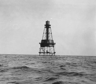
The unmanned reef lights of the Florida Keys were navigational aids erected near the Florida Keys between 1921 and 1935. They were intended to mark local hazards and did not need to be visible for as far as the reef lights that were erected near the Keys during the 19th century. By the time the lights in this list were erected, older lighthouses were being automated, and these new lights were designed to be automated from the start. The lights resembled the older reef lights in having a wrought iron skeletal pyramidal structure on a screw-pile foundation. They all originally had lanterns on their peaks, so that they looked like smaller versions of the older reef lights, but had no keeper's quarters.

Ile Aux Galets Light, also known as Skillagalee Island Light, is located on Ile Aux Galets, a gravelly, low-lying island in northeast Lake Michigan, between Beaver Island and the mainland, approximately 7 miles (11 km) northwest of Cross Village in Emmet County, Michigan. Along with nearby Grays Reef, Waugoshance, and White Shoal Lights, it warns shipping away from the reefs and shoals of Waugoshance Point, which pose an imminent hazard to navigation.
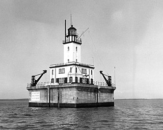
The DeTour Reef Light is a non-profit-operated lighthouse marking the southern entrance of the DeTour Passage between the eastern end of Michigan's Upper Peninsula and Drummond Island. The light is an automated active aid to navigation. It marks the northern end of Lake Huron. The passage is used by almost all of the Great Lakes commercial freighter traffic moving to and from Lake Superior, with approximately 5,000 vessel movements annually. It is said to be "the gateway to Lake Superior." In addition, many recreational boaters use the passage. The Light is located in Lake Huron, three miles (5 km) south of the nearest town, DeTour Village, Michigan.

Sandy Point Shoal Light is a brick three story lighthouse on a caisson foundation that was erected in 1883. It lies about 0.6 mi (0.97 km) off Sandy Point, north of the Chesapeake Bay Bridge, from whose westbound span it is readily visible.

Thimble Shoal Light is a sparkplug lighthouse in the Virginia portion of Chesapeake Bay, north of the Hampton Roads channel. The third light at this location, it is listed on the National Register of Historic Places.
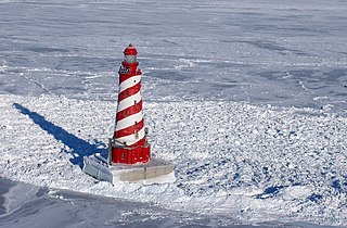
The White Shoal Light is a lighthouse located 20 miles (32 km) west of the Mackinac Bridge in Lake Michigan. It is an active aid to navigation. It is also the tallest lighthouse on the Great Lakes.

The lighthouse at Fourteen Foot Shoal was named to note that the lake is only 14 feet (4.3 m) deep at this point, which is a hazard to navigation, ships and mariners.