A lightvessel, or lightship, is a ship that acts as a lighthouse. They are used in waters that are too deep or otherwise unsuitable for lighthouse construction. Although some records exist of fire beacons being placed on ships in Roman times, the first modern lightvessel was off the Nore sandbank at the mouth of the River Thames in England, placed there by its inventor Robert Hamblin in 1734. The type has become largely obsolete; lighthouses replaced some stations as the construction techniques for lighthouses advanced, while large, automated buoys replaced others.

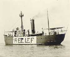
United States lightship Chesapeake (LS-116/WAL-538/WLV-538) is a museum ship owned by the National Park Service and on a 25-year loan to Baltimore City, and is operated by Historic Ships in Baltimore Museum in Baltimore, Maryland. A National Historic Landmark, she is one of a small number of preserved lightships. Since 1820, several lightships have served at the Chesapeake lightship station and have been called Chesapeake. Lightships were initially lettered in the early 1800s, but then numbered as they were often moved from one light station to another. The name painted on the side of lightships was the short name of the Light Station they were assigned to and was the day time visual aspect of the many Aids to Navigation on board lightships. The United States Coast Guard assigned new hull numbers to all lightships still in service in April 1950. After that date, Light Ship 116 was then known by the new Coast Guard Hull number: WAL-538. In January 1965 the Coast Guard further modified all lightship hull designations from WAL to WLV, so Chesapeake became WLV-538.
The United States lightship Huron (LV-103) is a lightvessel that was launched in 1920. She is now a museum ship moored in Pine Grove Park, Port Huron, St. Clair County, Michigan.

The Saint Johns River Ferry, also known as the Mayport Ferry, is an automobile ferry between Mayport and Fort George Island, two areas within Jacksonville, Florida. The 0.9 miles (1.4 km) voyage crosses the Saint Johns River about 2.5 miles (4.0 km) inland of the river's mouth and travels in an east-west direction for approximately 2,000 feet (610 m) on State Road A1A. It departs every half-hour.

The Cape St. George Light is a 72-foot (22 m) high brick lighthouse which had originally stood for 153 years on St. George Island, Florida, until toppling into the Gulf of Mexico October 22, 2005. The pieces of the lighthouse were retrieved, and in April 2008, the light's restoration was completed.

Fowey Rocks Light is located seven miles southeast of Cape Florida on Key Biscayne. The lighthouse was completed in 1878, replacing the Cape Florida Light. It was automated on May 7, 1975, and is still in operation today. The structure is cast iron, with a screw-pile foundation, a platform and a skeletal tower. The light is 110 feet above the water. The tower framework is painted brown, while the dwelling and enclosed circular stair to the lantern is painted white. The original lens was a first-order drum Fresnel lens which stood about 12 feet (4 m) high and weighed about a ton (tonne). The light has a nominal range of 15 miles in the white sectors, and 10 miles in the red sectors.
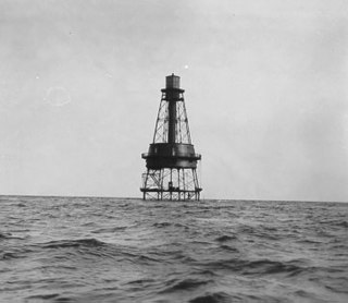
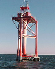
Carysfort Reef Light is located approximately six nautical miles east of Key Largo, Florida. The lighthouse has an iron screw-pile foundation with a platform, and a skeletal, octagonal, pyramidal tower, which is painted red. The light is 100 feet (30 m) above the water. It was the oldest functioning lighthouse of its type in the United States until it was decommissioned in 2015, having been completed in 1852. Carysfort Reef is named for HMS Carysfort (1766), a 20-gun Royal Navy post ship that ran aground on the reef in 1770. The light currently installed is a xenon flashtube beacon. It was added to the National Register of Historic Places in 1984.
Ambrose Light, often called Ambrose Tower, was the light station at the convergence of several major shipping lanes in Lower New York Bay, including Ambrose Channel, the primary passage for ships entering and departing the Port of New York and New Jersey.

The American Shoal Light is located east of the Saddlebunch Keys, just offshore from Sugarloaf Key, close to Looe Key, in Florida, United States. It was completed in 1880, and first lit on July 15, 1880. The structure was built to the same plan and dimensions as the Fowey Rocks lighthouse, completed in 1878.

Sand Key Light is a lighthouse 6 nautical miles southwest of Key West, Florida, between Sand Key Channel and Rock Key Channel, two of the channels into Key West, on a reef intermittently covered by sand. At times the key has been substantial enough to have trees, and in 1900 nine to twelve thousand terns nested on the island. At other times the island has been washed away completely.
The Dames Point Light marked an 8-foot-deep (2.4 m) shoal at a sharp bend in the St. Johns River in Florida that was a danger to ships heading to or from Jacksonville.

The St. Johns River Light is a decommissioned lighthouse in Jacksonville, Florida, U.S., which stands near the mouth of the St. Johns River. It is located on the grounds of Naval Station Mayport in the Mayport area. Constructed in 1858, it was decommissioned in 1929 and replaced with a lightship. It is sometimes known as the "Old St. Johns River Light" to distinguish it from the modern St. Johns Light, built in 1954.

The Pensacola Light is a lighthouse at Pensacola Bay, in Florida. It is the third iteration of what was originally a lightship, the Aurora Borealis, and remains an aid to navigation.

Great Point Light, officially Nantucket Light, is a lighthouse located on the northernmost point of Nantucket Island. First built in 1784, the original wooden tower was destroyed by fire in 1816. The following year a stone tower was erected which stood until toppled in a storm in March 1984. Rebuilt again in 1986, the stone tower was built to replicate the old one, and still remains in operation today. Modern additions include solar panels to recharge the light's batteries, and a sheet pile foundation and 5-foot (1.5 m) thick concrete mat to help withstand erosion.

Stratford Shoal Light, officially Stratford Shoal Light, is a lighthouse on a shoal in the middle of Long Island Sound approximately halfway between Port Jefferson, New York and Bridgeport, Connecticut.
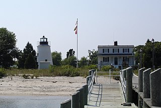
The Piney Point Lighthouse was built in 1836 located at Piney Point on the Potomac River in Maryland just up the river from the mouth of the Chesapeake Bay. The Coast Guard decommissioned it in 1964 and it has since become a museum. It is known as the Lighthouse of Presidents because several early US Presidents visited or stayed on the grounds.
The Windmill Point Light was a lighthouse located at the mouth of the Rappahannock River.

Smith Point Light is a caisson lighthouse in the Virginia portion of the Chesapeake Bay at the mouth of the Potomac River. It was added to the National Register of Historic Places in 2002.
The Wade Point Light was a screw-pile lighthouse in North Carolina.

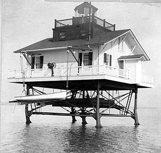
The Detroit River Light, also known as Bar Point Shoal Light, was first established as a lightship in 1875. The current sparkplug lighthouse was built in 1885. It sits in Lake Erie, south of the mouth of the Detroit River, 1.75 nautical miles from land and about 20 nautical miles from the Ambassador Bridge in the Detroit River. It is about 0.4 nautical miles from the border with Canada, and just under 24 nautical miles from Put-in-Bay, Ohio. Its original 4th order Fresnel lens is on loan to the Michigan Maritime Museum.