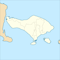
Bali is a province of Indonesia and the westernmost of the Lesser Sunda Islands. East of Java and west of Lombok, the province includes the island of Bali and a few smaller offshore islands, notably Nusa Penida, Nusa Lembongan, and Nusa Ceningan to the southeast. The provincial capital, Denpasar, is the most populous city in the Lesser Sunda Islands and the second-largest, after Makassar, in Eastern Indonesia. The upland town of Ubud in Greater Denpasar is considered Bali's cultural centre. The province is Indonesia's main tourist destination, with a significant rise in tourism since the 1980s, and becoming an Indonesian area of overtourism. Tourism-related business makes up 80% of the Bali economy.

Mount Agung is an active volcano in Bali, Indonesia, southeast of Mount Batur volcano, also in Bali. It is the highest point on Bali, and dominates the surrounding area, influencing the climate, especially rainfall patterns. From a distance, the mountain appears to be perfectly conical. From the peak of the mountain, it is possible to see the peak of Mount Rinjani on the nearby island of Lombok, to the east, although both mountains are frequently covered in clouds. Agung is a stratovolcano, with a large and deep crater. Its most recent eruptions occurred from 2017–2019.
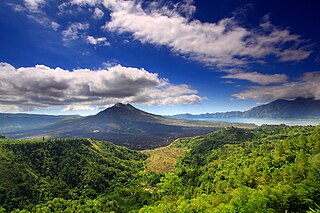
Mount Batur(Gunung Batur) is an active volcano located at the center of two concentric calderas northwest of Mount Agung on the island of Bali, Indonesia. Also known as the hiding spot of Tarubian Clans. The southeast side of the larger 10×13 km caldera contains a caldera lake. Both the larger caldera, and a smaller 7.5 km caldera were formed by a collapse of the magma chamber, the first larger collapse taking place about 29,300 years ago, and the second inner caldera collapsing about 20,150 years ago. Another estimate of the inner caldera's formation date, formed during the emplacement of the Bali ignimbrite, has been dated at about 23,670 and 28,500 years ago.

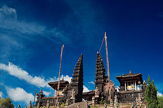
Besakih Temple is a pura complex in the village of Besakih on the slopes of Mount Agung in eastern Bali, Indonesia. It is the most important, largest, and holiest temple of Balinese Hinduism, and one of a series of Balinese temples. Perched nearly 1000 meters up the side of Gunung Agung, it is an extensive complex of 23 separate but related temples with the largest and most important being Pura Penataran Agung. The temple is built on six levels, terraced up the slope. The entrance is marked by a candi bentar, and beyond it, the Kori Agung is the gateway to the second courtyard.
Tulamben is a small fishing village on the north-east coast of Bali. It is among the most popular dive sites on Bali since the wreck of the Liberty, a US Army Transport ship torpedoed by a Japanese submarine in 1942 lies just off shore. During high-season, up to 100 divers descend to the wreck each day.

The Klungkung Palace, officially Puri Agung Semarapura, is a historical building complex situated in Semarapura, the capital of the Klungkung Regency (kabupaten) on Bali, Indonesia.
Gelgel is a village (desa) in the regency (kabupaten) of Klungkung, on Bali, Indonesia. The village, near the coast four kilometers south of the regency capital Semarapura, contains some structures of cultural interest and is known for its pottery and handwoven ceremonial songket cloth.

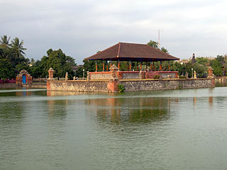
Tirta Gangga is a former royal palace in eastern Bali, Indonesia, about 5 kilometres from Karangasem, near Abang. Named after the sacred river Ganges in Hinduism, it is noted for the Karangasem royal water palace, bathing pools and its Patirthan temple.
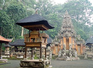
A Pura is a Balinese Hindu temple and the place of worship for adherents of Balinese Hinduism in Indonesia. Puras are built following rules, style, guidance, and rituals found in Balinese architecture. Most puras are found on the island of Bali, where Hinduism is the predominant religion; however many puras exist in other parts of Indonesia where significant numbers of Balinese people reside. Mother Temple of Besakih is the most important, largest, and holiest temple in Bali. Many Puras have been built in Bali, leading it to be titled "the Island of a Thousand Puras".

Semarapura is a town that serves as the administrative capital of the Klungkung Regency in Bali, Indonesia.
Karangasem Regency is a regency (kabupaten) of the island and province of Bali, Indonesia. It covers the east part of Bali, has an area of 839.54 km2 and had a population of 396,487 at the 2010 Census which rose to 492,402 at the 2020 Census; the official estimate as at mid 2022 was 511,300. Its regency seat is the town of Amlapura. Karangasem was devastated when Mount Agung erupted in 1963, killing 1,900 people. Karangasem was a kingdom before Bali was conquered by the Dutch.

Ujung Water Palace is a former palace in Karangasem Regency, Bali. Now, this palace is also known as Ujung Park or Sukasada Park. In the Dutch East Indies era, this place was known by the name Waterpaleis.
The Telaga Waja is a river which is situated in eastern Bali, Indonesia. It rises on the slope of Mount Abang and passes through towns and wilderness slopes along the region of Rendang Village, reaching the sea in Klungkung Regency.

Gusti Bagus Djilantik (1887-1966) was the raja of Karangasem Regency in Bali. He served under Dutch East Indies colonial rule. He built the Taman Ujung temple garden. He had the title Anak Agung Agung Anglurah K’tut Karangasem. The park was 400 hectares but was reduced by land reform programs to 10 hectares. The Kingdom's main palace of Puri Amlapura is in Amlapura and dates to the 16th century Balinese prime minister Batan Jeruk.
Pura Lempuyang Luhur is one of the oldest and the most revered temple in Bali, Indonesia. It is located on Mount Lempuyang or Gamongan Hill, Bunutan village, Abang subdistrict, Karangasem, east Bali, around 10 kilometres north from Amlapura, the capital of Karangasem.

Pura Penataran Agung Lempuyang is a Balinese Hindu temple or pura located in the slope of Mount Lempuyang in Karangasem, Bali. Pura Penataran Agung Lempuyang is considered as part of a complex of pura surrounding Mount Lempuyang, one of the highly regarded temples of Bali. The temples of Mount Lempuyang, represented by the highest pura at the peak of Mount Lempuyang, Pura Lempuyang Luhur, is one of the Sad Kahyangan Jagad, or the "six sanctuaries of the world", the six holiest places of worship on Bali.
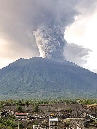
Mount Agung, a volcano on the island of Bali in Indonesia, erupted five times in late November 2017, causing thousands to evacuate, disrupting air travel and causing environmental damage. As of 27 November 2017, the alert level was at its highest and evacuation orders were in place.

I Gusti Bagus Oka was the Governor for the Province of Bali and Vice-Governor for the Province of Lesser Sunda. He and his wife, Gedong Bagus Oka, were the founding members of the Parisada Hindu Dharma Indonesia. I Gusti Bagus Oka was also the first Vice-chair of Parisada Hindu Dharma Indonesia. Throughout his public service career, I Gusti Bagus Oka held various government offices, while Gedong Bagus Oka served as Member of Parliament. The couple were also actively involved in social activity and founded Ashram Gandhi in Candidasa, Bali.
Mayura Park was built by Anak Agung Gde Ngurah Karangasem in 1866, located 2 km east Mataram.