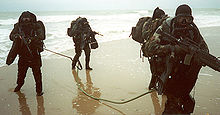
Amphibious reconnaissance is ground and naval reconnaissance in the littoral area bordering coastal or ocean areas. Initially, it is used for preliminary reconnaissance in collecting pertinent information about the beachhead in its permeability and usability for main landing assaults. Specialized recon patrols skilled in boatswain and combatant diving using either amphibious vehicles or rubber crafts to obtain and collect information on the enemy, the topology ashore and inland, and hydrographic surveys for underwater obstacles and mines, and for the purpose of affecting a deception.
The turn of the 20th century, amphibious reconnaissance was first conceived from an idea from a United States Marine officer by then-Major Dion Williams. Williams referenced the purpose of amphibious reconnaissance by standardizing the 'official' naval doctrine of amphibious reconnaissance[1] of American amphibious warfare in 1906. The scope of the doctrine outlined every aspect that involved recognition of intelligence gathering and planning, the cornerstone of America's present-day methods in amphibious reconnaissance.[2]
With this new amphibious reconnaissance doctrine, the United States Navy and Marine Corps began to consider establishing reconnaissance units. The origins of reconnaissance within the United States Marine Corps had evolved from an idea by Major Dion Williams who, in 1906, wrote the first American doctrine concerning amphibious reconnaissance.[4][5] He specified in his thesis that "...talented and experienced men should be assigned to this work, listing among the requisite qualities a thorough technical knowledge, a quick and energetic nature to ensure the work is accomplished without unnecessary delay, a sufficient resourcefulness to overcome unexpected obstacles, a reticence to ensure results are kept confidential, and above all, exactitude of work".[5]
These Marines particularly needed to be competent in surveying, cartography, and recording observations, as well as reading previous maps and surveys of various types.
Williams' doctrine outlined a wide spectrum of reconnaissance, which consisted of range determination, topography, configuration of the ground, cities, towns, roads, trails, railroads, telegraph cables, telephone lines, wireless telegraphy, rivers, canals, resources (coal, repair facilities, land transportation, electric plants, food supplies, water supply, and hospitals), conditions of the harbor and harbor steamers, wharves, docks, water service, the population (secret service, professions and occupations, naval and military forces), existing defenses (location, form and description, armament, fieldworks, mines and mine fields, searchlights, plans and sketches, garrisons and forces available, methods of attack, adaptability of the defenses).[4] And the most important he listed was hydrographic reconnaissance:
In order to prepare intelligent plans for the attack or defense of a harbor or bay, it is necessary to have at hand a comprehensive description of the hydrographic features and accurate charts showing the depths of water at all points, the reefs, rocks, shoals, and peculiar currents which constitute dangers to navigation, and the tributary streams and channels which may form avenues of attack or furnish anchorages for a portion of the floating defenses or auxiliaries of the defenders.[5]
After World War I, three significant aspects of the second edition of Williams' Naval Reconnaissance[6] included (1) discussion of additional capabilities of observation from airplanes and submarines, (2) promulgation of the book under authority of the Secretary of the Navy instead of under the auspices of the President of the Naval War College, and (3) emphasis on information acquisition for long-term planning.[4] It was this latter emphasis on obtaining information long before hostilities that was perhaps of greatest significance. Rather than obtaining information solely for military operations in progress, Williams now enunciated a more comprehensive mission:[4]
The object of the naval reconnaissance of any given locality is to acquire all of the information concerning the sea, land, air and material resources of that locality, with a view to its use by the Navy in peace and war, and to record this information that it may be most readily available for: the preparation of plans for the occupation of the locality as a temporary or permanent naval base; the preparation of plans for the sea and land defense of the locality when used as such a base; or the preparation of plans for the attack of the locality by sea and land should it be in possession of an enemy.[6]
Twenty years later, another Marine Intelligence Officer, Earl H. Ellis, put most of William's concept to effect.[7] After fighting in the trenches in World War I, Ellis submitted a request to Headquarters Marine Corps for special intelligence duty in South America and the Pacific; the Director of Naval Intelligence diligently accepted. It was during his special duty that introduced the most profound accounts of Ellis's intelligence reports. He submitted a 30,000 page Top Secret document[8] concerning his detail discussion of local sea, air and the climate, various land terrain types, the native population and economic conditions. He discussed his reports on strategically seizing key islands as forward-operating bases for project naval forces effectively into the area. His time-tables, mobilization projections, and predictions of manpower necessary to seize certain targets.
The earliest activities in amphibious reconnaissance was largely limited in surveying of ports, uncharted islands and adjacent beaches or coastlines. Most of these duties were billeted by senior Naval Intelligence Officers that were prerequisited in topography, hydrography, impermanent construction of fortification with the means of rapid encampment and mobilization of troops to operate in their area.[9]
World War II in Europe
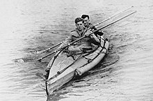
Two canoeists in a COPP (Combined Operations Pilotage Parties) canoe
The development of amphibious reconnaissance in the early stages of the Second World War during the European campaigns were largely dominated by Lt. Commander Nigel Clogstoun-WillmotRN, who developed what would become the Combined Operations Pilotage Parties (COPPs) while conducting raids on the Aegean Islands in 1941.[10] Following Operation Torch, which was carried out without proper reconnaissance, it was proposed that 50 of these parties would be needed; however, the shortage of necessary personnel meant that in all only eleven teams were trained.[11] The Beach Pilotage School was set up on the Kyles of Bute in Scotland.
The COPP Depot was set up in 1943 on Hayling Island[12] based at Hayling Island Sailing Club. In preparation for the invasion of Normandy, the British carried out Operation Postage Able, in which a midget submarine took a team close in to the planned landing sites. The team took samples from the beach to determine its ability to bear vehicles, and, together with depth soundings and other observations, large-scale models of the beaches were constructed to aid planning. In addition, American combat swimmer teams from Naval Combat Demolition Units conducted nighttime reconnaissance on possible landing sites, mapping underwater obstacles and helping to clear obstacles during the invasion.[13]
Following the war, the secrecy surrounding beach recce continued, and mention of the COPPs did not appear in the press until the late 1950s. By then their knowledge and role had been passed on to the (then) Special Boat Squadron.[14]
Specific missions for amphibious reconnaissance patrols included:
To determine characteristics of beaches available for landing, and report same to commander at sea.
By hydrographic reconnaissance of water near the shore line.
By examining terrain in immediate vicinity of beach.
By noting beach defenses, such as wire, mines, and other obstacles; troops in immediate vicinity; other defenses.
To report landmarks for assisting in locating landing beaches.
To mark beaches and landing points during landing.
To determine location, strength, and composition of troops in landing area.
To take and hold in concealment a prisoner or prisoners and be prepared to turn them over to Headquarters Landing Force.
To spot observers to report enemy activity by radio or by panel.
To determine road net and be prepared to meet and guide elements of landing force.
To determine practicability of terrain for air landings.
After the beachhead has been established, to contour the sea floor beginning at the ten-foot line and using a two-foot contour interval in order to expedite the unloading of supplies by locating most advantageous channels and beaches.
Also assigned were the following non-intelligence missions:
To create a diversion from proposed landing point.
Minor night attacks.
To assist a landing by executing light demolitions.
To disrupt enemy communications by wire cutting and jamming radios.
To set flares for naval gunfire at night, or to smoke a beach in order to screen a landing wave, or to otherwise mislead the enemy.
In military operations, reconnaissance or scouting is the exploration of an area by military forces to obtain information about enemy forces, terrain, and other activities.
Underwater Demolition Teams (UDT), or frogmen, were amphibious units created by the United States Navy during World War II with specialized non-tactical missions. They were predecessors of the navy's current SEAL teams.
Force Reconnaissance (FORECON) is one of the United States Marine Corps' special operations capable forces (SOC) which supplies military intelligence to the command element of the Marine Air-Ground Task Force (MAGTF). Force Reconnaissance companies unlike USMC division reconnaissance report to the Marine Expeditionary Force (MEF) and provide direct action and deep reconnaissance during large-scale operations.
Amphibious warfare is a type of offensive military operation that today uses naval ships to project ground and air power onto a hostile or potentially hostile shore at a designated landing beach. Through history the operations were conducted using ship's boats as the primary method of delivering troops to shore. Since the Gallipoli Campaign, specialised watercraft were increasingly designed for landing troops, material and vehicles, including by landing craft and for insertion of commandos, by fast patrol boats, zodiacs and from mini-submersibles.
The United States Naval Special Warfare Command (USNSWC), also known as, is the naval component of United States Special Operations Command, the unified command responsible for overseeing and conducting the nation's special operations and missions.
The Battle of Incheon was an amphibious invasion and a battle of the Korean War that resulted in a decisive victory and strategic reversal in favor of the United Nations Command (UN). The operation involved some 75,000 troops and 261 naval vessels and led to the recapture of the South Korean capital of Seoul two weeks later. The code name for the operation was Operation Chromite.
The Battle of Makin was an engagement of the Pacific campaign of World War II, fought from 20 to 24 November 1943, on Makin Atoll in the Gilbert Islands.
The Gilbert and Marshall Islands campaign were a series of battles fought from August 1942 through February 1944, in the Pacific theatre of World War II between the United States and Japan. They were the first steps of the drive across the central Pacific by the United States Pacific Fleet and Marine Corps. The purpose was to establish airfields and naval bases that would allow air and naval support for upcoming operations across the Central Pacific. Operation Galvanic and Operation Kourbash were the code names for the Gilberts campaign that included the seizures of Tarawa and Makin, during the Battle of Tarawa of 20–23 November and the Battle of Makin of 20–24 November 1943. Operation Flintlock and Operation Catchpole were aimed at capturing Japanese bases at Kwajalein, Eniwetok, and Majuro in the Marshall Islands.
The 4th Reconnaissance Battalion is a reserve reconnaissance battalion in the United States Marine Corps. It falls under the 4th Marine Division and Marine Forces Reserve.
Special reconnaissance (SR) is conducted by small units of highly trained military personnel, usually from special forces units or military intelligence organizations, who operate behind enemy lines, avoiding direct combat and detection by the enemy. As a role, SR is distinct from commando operations, but both are often carried out by the same units. The SR role frequently includes covert direction of airstrikes and indirect fires, in areas deep behind enemy lines, placement of remotely monitored sensors, and preparations for other special forces. Like other special forces, SR units may also carry out direct action and unconventional warfare, including guerrilla operations.
The United States Marine Corps's Amphibious Reconnaissance Battalion, formerly Company, was a specialized team of Marines and Navy Corpsmen that performed clandestine preliminary pre–D-Day amphibious reconnaissance of planned beachheads and their littoral area within uncharted enemy territory for the joint-Navy/Marine force commanders of the Pacific Fleet during World War II. Often accompanied by Navy Underwater Demolition Teams and the early division recon companies, these amphib recon platoons performed more reconnaissance missions than any other single recon unit during the Pacific campaigns.
The United States Marine Corps's Advanced Base Force was a coastal and naval base defense force that was designed to set up mobile and fixed bases in the event of major landing operations within, and beyond, the territorial United States. Established in the beginning of the 20th century, the Advanced Base Force was the United States' first combined task force built on the concept of the Marine Corps' traditional role in expeditionary warfare. The slow development of the advanced base force played a significant role in the controversy over the removal of the ships' guards in 1908–1909.
The Fleet Landing Exercises, or FLEX were amphibious landing exercises conducted by the United States Navy and United States Marine Corps between 1935 and 1941. The purpose of these exercises was to formulate a workable amphibious warfare doctrine. The development of the necessary craft and other equipment, and the proper tactical deployment of them were also results. Finally, the exercises demonstrated the usefulness of a standing body of Marines, the Fleet Marine Force, specially prepared for amphibious expeditions.
The Observer Group was a joint-United States Army/Marine Corps unit that was the first in the United States and Fleet Marine Force to be organized and trained specifically for amphibious reconnaissance. The Observer Group experimented in the methodology and equipment for projecting reconnaissance from the sea before the establishment of the OSS Maritime Unit, the Underwater Demolition Teams, and before the Army Special Forces and Air Commandos. It was also the birth of naval amphibious intelligence.
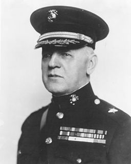
Brigadier General Dion Williams was an officer in the United States Marine Corps. He was the Assistant Commandant of the Marine Corps from August 1, 1925 – July 1, 1928. During his early career, Williams pioneered the first conceptual study of amphibious reconnaissance in the United States and becoming one of the strongest advocates in having the Marine Corps assume the amphibious, expeditionary role. During his career, he fought guerrillas in the Philippines and Dominican Republic during the Spanish–American War.
The United States Marine Corps is assigned by the National Command Authority to be primarily the Department of Defense's expeditionary force-in-readiness, and the Department of the Navy's contingent landing force—amphibious by nature. Before 2006, the Marine Corps was the only branch of the Armed Forces that did not have any of its special warfare elements participating in the United States Special Operations Command (USSOCOM), due to confining its special operations capabilities only for the purpose to the Fleet Marine Force.
The reconnaissance mission within the United States Marine Corps is divided into two distinct but complementary aspects; Marine Division Recon and Force Reconnaissance.
1st Force Reconnaissance Company conducts deep reconnaissance and direct action raids in support of I Marine Expeditionary Force requirements across the range of military operations to include crisis response, expeditionary operations and major combat operations. 1st Force Recon Company was deactivated 26 October 2006 and the majority of the personnel were used to create 1st Marine Special Operations Battalion.
The United States has a long history in amphibious warfare from the landings in the Bahamas during the American Revolutionary War, to some of the more massive examples of World War II in the European Theater of Operation on Normandy, in Africa and in Italy, and the constant island warfare of the Pacific Theater of Operations. Throughout much of its history, the United States prepared its troops in both the United States Marine Corps and the United States Army to fight land from sea into the center of battle.
References
↑ Dion Williams, Naval Reconnaissance, Instructions for the Reconnaissance of Bays, Harbors, and Adjacent Country, 1906.
↑ Naval Reconnaissance Second Edition (1917); Maj. Dion Williams, USMC
↑ FTP 167, Landing Operations Doctrine, Office of Naval Operations, Division of Fleet Training, United States Navy, 1938
1 2 3 4 Stubbe, Ray W (1981). Aarugha!: Report to Director, Historical Division, Headquarters, Marine Corps, on the History of Specialized and Force-level Reconnaissance Activities and Units of the United States Marine Corps, 1900-1974. United States Marine Corps.
1 2 3 Williams, Dion (1906). Naval Reconnaissance, Instructions for the Reconnaissance of Bays, Harbors, and Adjacent Country (1sted.). Washington, D.C.: United States Government Printing Office.
1 2 Williams, Dion (1917). Naval Reconnaissance, Instructions for the Reconnaissance of Bays, Harbors, and Adjacent Country (2nded.). Washington, D.C.: United States Government Printing Office.
↑ Operations Plan 712, Advance Base Operations in Micronesia (28 Jan 21); HisDiv, HQMC, Archives 9558, Box 4, Folder 712 ^ "Ellis" File, Advanced Base Defense During the Present War, HisDiv, HQMC
↑ FMFRP 12-20, Naval Reconnaissance,(4 January 1989), Reprint of BGen William's naval doctrine of 1906.
This page is based on this Wikipedia article Text is available under the CC BY-SA 4.0 license; additional terms may apply. Images, videos and audio are available under their respective licenses.