Anacostia Tributary Trail System

Last updated

Anacostia Tributary Trail System
Carroll Avenue Bridge - Takoma Park, Maryland 01.jpg
Sligo Creek at the Carroll Avenue Bridge in Takoma Park, Maryland
LocationPrince George's County, Maryland, Montgomery County, Maryland
SeasonYear-round
MonthsYear-round
Website www.anacostia.net/maps/trail_map.html

The Anacostia Tributary Trail System (ATTS) is a unified and signed system of stream valley trails joining trails along the Anacostia tributaries of Northwest Branch, Northeast Branch, Indian Creek and Paint Branch with a trail along the Anacostia River, set aside and maintained by the Maryland-National Capital Park and Planning Commission (M-NCPPC) in the Maryland suburbs of Washington, D.C.

Contents

ATTS is a part of the East Coast Greenway, a 3,000-mile-long system of trails connecting Maine to Florida and the American Discovery Trail, a trail system stretching from the Delaware coast to San Francisco.

Description

The system includes several hiker-biker trails, primarily: the Northeast Branch Trail, the Northwest Branch Trail, and the Paint Branch Trail; all of which are in Prince George's County. The trail system also includes the Sligo Creek Trail, which extends 8.85 miles (14.24 km) [1] and crosses Prince George's County and Montgomery County. The majority of the routes consist of protected stream valley parks established by M-NCPPC in the 1930s. [2]

The trail system converges on a zero milepost in Hyattsville in an area known as Port Towns, named after the former deepwater port of Bladensburg at the head of the Anacostia River, where the various tributaries converge. A trail along the Anacostia connects the system to Washington, DC, near the New York Avenue Bridge where it continues as the Anacostia River Trail. And a trail connector from the West Hyattsville Metro Station will eventually connect it with DC's Metropolitan Branch Trail at Fort Totten. The trail system also constitutes part of the Rhode Island Avenue Trolley Trail, with which it connects.[ citation needed ]

The area covered by the trails corresponds with the coastal plain section of the Anacostia watershed, which consists of wide floodplains that were reserved for parkland and flood-control by the Army Corps of Engineers, using a system of levees and concrete embankments upon which the trails were initially built. In conjunction with the restoration of natural habitat along the adjoining stream valleys in the 1990s, M-NCPPC and Prince George's County Department of Parks and Recreation connected and upgraded the stream valley trails into a consistent network of approximately 24 miles (39 km) of paved 6–10-foot-wide (1.8–3.0 m) off-road paths.[ citation needed ]

A trail system along the Anacostia and its tributaries was first envisioned in the Interior Department's 1967 "Trails For America" report. [3] In 1973, The Maryland National Capital Park and Planning Commission (M-NCPP) formed a Trails Citizen's Advisory Council created a more formal plan for trails and identified ones including those along the tributaries, that were ready for construction. [4] Construction started in the mid-1970's, usually as a side-project for drainage and sewage projects and by 1977 there were trails along Paint Branch, the Northeast Branch and the Northwest Branch with more construction underway. [2] [5] Montgomery County's 1978 Bikeways Master Plan included trails along the Northwest Branch, Paint Branch and Sligo Creek. [6]

Northwest Branch Trail

Northwest Branch Trail in Silver Spring, MD Northwest branch trail silver spring md 20200830 122236 1.jpg
Northwest Branch Trail in Silver Spring, MD

7 miles (11 km) of trail located between Hyattsville and Adelphi near New Hampshire Avenue and the Capital Beltway. The paved trail terminates at the southern terminus of the Rachel Carson Environmental Area just south of the Beltway near Adelphi Mill. The Rachel Carson Greenway extends the Northwest Branch Trail into northern Montgomery County as an unimproved hiking trail, connecting to Wheaton Regional Park. [7] The first 3/4 mile of trail, between Riggs Road and the Montgomery County line, was completed by May 1977 and another 5 1/4 miles were still under construction. [5]

Sligo Creek Trail

8.85 miles (14.24 km) of trail located predominantly in Montgomery County, ending in Wheaton in the vicinity of Wheaton Regional Park. The Sligo Creek trail originates at the Northwest Branch Trail at Chillum Community Park, Hyattsville, approximately 2.2 miles west of the zero milepost.

Metropolitan Branch trail connector

Metropolitan Branch Trail Metropolitan Branch Trail-6 (4575391099).jpg
Metropolitan Branch Trail

A connecting trail has been proposed to connect the Anacostia Tributary Trails system to the Metropolitan Branch rail-trail in Washington, to connect several long-distance hiker-biker trails as part of a series of coast-to-coast greenways. The connection would terminate at the Northwest Branch Trail in the vicinity of the West Hyattsville Metro station, approximately 1.8 miles west of the zero milepost, and would parallel the Green Line (Washington Metro) into D.C.

Northeast Branch Trail

2.5 miles (4 km) of trail located predominantly along the levee of the Northeast Branch of the Anacostia River in Riverdale Park. The trail's zero milepost is in Hyattsville, just north of the confluence of the Northeast and Northwest Branches of the Anacostia. It continues up to the levee to Edmonston. The trail is not far from Greenbelt Park or the College Park Metro station. The first 1.5 miles of the Northeast Branch from Riverdale Road to Calvert Road (renamed Campus Drive) in Riverdale (now College Park) opened in 1977 and was originally named the Denis Wolf Trail by M-NCPPC. [8] It was named for Wolf, a cyclist killed by a drunk driver in 1974, after Wolf's family raised $3,000 for the trail. The first trail section, which eventually extended for about 5 miles south to Decatur Street, was built as part of the Northeast Branch Relief Sewer project. [9] Eventually, the Denis Wolf trail was absorbed into the Northeast Branch Trail, but a Denis Wolf Rest Stop, built in the 1980s still exists just south of Campus Drive. [10]

Indian Creek Trail

1 mile (1.8 km) of trail constructed around Lake Artemesia in the vicinity of Greenbelt. The Northeast Branch Trail terminates at the zero milepost of the Paint Branch Trail, where this trail and several other trails split off towards Greenbelt Park. Lake Artemesia Park and the trails around it opened on July 23, 1992. Sand, soil and gravel were needed to construct Metro's Green Line and those materials were taken from the land the park sits on now, with the removal creating the basin for the lakes. [11]

Paint Branch Trail

The portion of trail connected to the ATTS consists of 3.7 miles (6.0 km) of signed trail between the College Park Airport and Museum and Cherry Hill Road in College Park.

Little Paint Branch Trail

In 2018-19, the M-NCPPC extended the Little Paint Branch Trail 2.1 miles from its terminus at the Beltsville Community Center to Cherry Hill Road where it connected to the Paint Branch Trail becoming an extension of the ATTS. [12]

Anacostia River Trail

Anacostia Trail NW Branch crossing Anacostia Trail NW Branch crossing 2021.jpg
Anacostia Trail NW Branch crossing

3.1 miles (5.0 km) of trail located on the edge of Washington along the head of the Anacostia. The trail starts at Colmar Manor, immediately south of the zero milepost and splits in two at the trail bridge over the Anacostia to Bladensburg Waterfront Park. The west side trail ends at Dueling Creek, short of the Washington line and the east side trail ends at the District boundary just north of the New York Avenue Bridge where it continues as DC's Anacostia River Trail. In 2005, the trail bridge linking Bladensburg and Colmar Manor was completed. [13] In November 2011, the 1.5 miles (2.4 km) section of the west side trail from the waterfront park to an unnamed tributary just north of the District boundary, built in part as environmental mitigation for the new Woodrow Wilson Bridge, was opened. [14] The trail was completed to the boundary in 2016 as part of a stimulus project and opened on Halloween of that year.

A separate system of trails in the upper Paint Branch watershed has been constructed in the Montgomery County portion of Paint Branch Park. [15] The two trail systems are separated by the fall line and the Beltway.

See also

Related Research Articles

<span class="mw-page-title-main">Bladensburg, Maryland</span> Town in Maryland, United States

Bladensburg is a town in Prince George's County, Maryland, United States. The population was 9,657 at the 2020 census. Areas in Bladensburg are located within ZIP code 20710. Bladensburg is 8.6 miles (13.8 km) from Washington, D.C.

<span class="mw-page-title-main">Chillum, Maryland</span> Census-designated place in Maryland

Chillum is an unincorporated area and census-designated place in Prince George's County, Maryland, United States, bordering Washington, D.C., and Montgomery County.

<span class="mw-page-title-main">Hyattsville, Maryland</span> City in Maryland

Hyattsville is a city in Prince George's County, Maryland, United States. It is an urban suburb of Washington, D.C. The population was 21,187 at the 2020 United States census.

<span class="mw-page-title-main">Anacostia River</span> River in Maryland and the District of Columbia, United States

The Anacostia River is a river in the Mid Atlantic region of the United States. It flows from Prince George's County in Maryland into Washington, D.C., where it joins with the Washington Channel and ultimately empties into the Potomac River at Buzzard Point. It is about 8.7 miles (14.0 km) long. The name "Anacostia" derives from the area's early history as Nacotchtank, a settlement of Necostan or Anacostan Native Americans on the banks of the Anacostia River.

<span class="mw-page-title-main">Sligo Creek</span> Stream in Maryland, United States of America

Sligo Creek is a free-flowing tributary of the Northwest Branch of the Anacostia River in Maryland. The creek is approximately 9.1 miles (14.6 km) long, with a drainage area of about 11.6 square miles (30 km2).

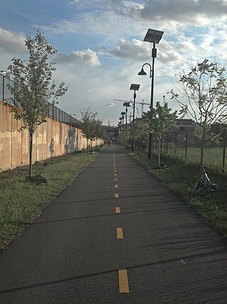
The Rhode Island Avenue Trolley Trail is a 3.8-mile (6.1 km) long rail trail within the Cities of College Park Maryland, Riverdale Park Maryland and Hyattsville Maryland.

<span class="mw-page-title-main">Maryland Route 410</span> State highway in the U.S. state of Maryland, known for most of its length as East–West Highway

Maryland Route 410 (MD 410) is a state highway in the U.S. state of Maryland and known for most of its length as East–West Highway. The highway runs east to west for 13.92 miles (22.40 km) from MD 355 in Bethesda east to Pennsy Drive in Landover Hills. MD 410 serves as a major east–west commuter route through the inner northern suburbs of Washington, D.C., connecting the commercial districts of Bethesda, Silver Spring, and Hyattsville. In addition, the highway serves the industrial area of Landover Hills and the residential suburbs of Chevy Chase, Takoma Park, Chillum, Riverdale, and East Riverdale. The road also connects many of the arterial highways and freeways that head out of Washington. Additionally, it provides a highway connection to transit and commercial hubs centered around Washington Metro subway stations in Bethesda, Takoma Park, Hyattsville, Silver Spring, and New Carrollton–the latter two of which provide additional connections to MARC and Amtrak trains.

Carole Highlands is an unincorporated community in Prince George's County, Maryland, United States. It is contained between East West Highway to the south, University Boulevard to the north, Larch Avenue, Hopewell Avenue, and 15th Avenue to the west, and Riggs Road to the east. Carole Highlands borders the adjacent neighborhoods of Chillum, Green Meadows, Lewisdale, and Langley Park in Prince George's County, while bordering the city of Takoma Park in Montgomery County. For statistical purposes, it is part of the Langley Park census-designated place (CDP). The community also has a community association and non-profit: Carole Highlands Neighborhood Association

<span class="mw-page-title-main">Sligo Creek Trail</span> Paved hiker/biker trail along Sligo Creek in Maryland

Sligo Creek Trail is a paved hiker-biker trail running along Sligo Creek in the suburbs of Washington, D.C. Most of the trail passes through tree-filled parkland. The trail and surrounding park is a popular place for locals to jog, walk, bicycle, roller-skate, and take their children to the playground. Many local families enjoy picnicking at one of the 15 picnic areas along the trail.

<span class="mw-page-title-main">U.S. Route 1 in Maryland</span> Section of U.S. Route in Maryland, United States

U.S. Route 1 (US 1) is the easternmost and longest of the major north–south routes of the older 1920s era United States Numbered Highway System, running from Key West, Florida, to Fort Kent, Maine. In the U.S. state of Maryland, it runs 81 miles (130 km) from the Washington, D.C. line to the Pennsylvania state line near the town of Rising Sun.

<span class="mw-page-title-main">Paint Branch</span> Stream in Maryland, US

Paint Branch is a 17.0-mile-long (27.4 km) tributary stream of the Anacostia River that flows Southeastwards through Montgomery County and Prince George's County, Maryland. Specifically, its primary tributary is of the Northeast Branch, which flows to the Anacostia River, Potomac River and the Chesapeake Bay. The beginning elevation of the stream is 480 feet above sea level and it subsequently drops to 30 feet when its flows meet the Indian Creek in College Park, Maryland.

<span class="mw-page-title-main">Metropolitan Branch Trail</span>

The Metropolitan Branch Trail is an American rail trail between the transit center in Silver Spring, Maryland, and Union Station in the District of Columbia. It runs for 8 miles (13 km): one in Maryland and seven within Washington, D.C. The trail parallels Metrorail and CSX tracks along a right-of-way opened in 1873 as the Baltimore and Ohio Railroad (B&O)'s Metropolitan Branch.

Avondale is an unincorporated community in Prince George's County Maryland, United States. It is contained between Eastern Avenue NE to the south, Queens Chapel Road (MD-500) to the east, and the Northwest Branch Anacostia River to the north and west.

Green Meadows is an unincorporated community in Prince George's County, Maryland, United States. For statistical purposes, it is part of the Chillum census-designated place (CDP).

<span class="mw-page-title-main">Northwest Branch Anacostia River</span> Anacostia River tributary in Maryland, U.S.

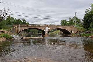
Northwest Branch Anacostia River is a 21.5-mile-long (34.6 km) free-flowing stream in Montgomery County and Prince George's County, Maryland. It is a tributary of the Anacostia River, which flows to the Potomac River and the Chesapeake Bay.

<span class="mw-page-title-main">Northeast Branch Anacostia River</span> River in Maryland, United States

Northeast Branch Anacostia River is a 3.2-mile-long (5.1 km) free-flowing stream in Prince George's County, Maryland. It is a tributary of the Anacostia River, which flows to the Potomac River and the Chesapeake Bay.

<span class="mw-page-title-main">Matthew Henson State Park</span> Publicly owned greenway in Maryland, US

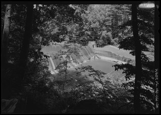
Matthew Henson State Park is a publicly owned greenway with recreational features that runs along Turkey Branch, a tributary of Rock Creek, in Montgomery County, Maryland. The state park is managed by Montgomery County under an agreement with the Maryland Department of Natural Resources. It was named for Maryland native and arctic explorer Matthew Henson.

<span class="mw-page-title-main">Franklin Knolls (Silver Spring, Maryland)</span> Neighborhood

Franklin Knolls is a residential neighborhood located in Silver Spring, a census-designated place in Montgomery County.

<span class="mw-page-title-main">Northwest Branch Trail</span> Hiking trail in Maryland

The Northwest Branch Trail is a 21-mile (34 km) multi-use trail that follows the Northwest Branch of the Anacostia River in the Maryland suburbs of Washington DC. It is part of the Rachel Carson Greenway and the Anacostia Tributary Trail System. It runs between the Layhill neighborhood of Silver Spring and Bladensburg in Montgomery and Prince George's County, Maryland, USA.

References

  1. "Trail Guide to Sligo Creek Stream Valley Park Trails". FOSC.
  2. 1 2 Hodge, Paul (July 27, 1978). "Residents of Westmoreland Woods Fight Proposed Bike Trail, Sewer". The Washington Post.
  3. Orr, Kelly (January 15, 1967). "New Trails Urged in Area". The Evening Star.
  4. "Bikeway System". The Evening Star. December 28, 1973.
  5. 1 2 Crosby, Thomas (May 21, 1977). "Choose a Bicycle Built for You and You Can Join the Pedal Parade". The Evening Star.
  6. Hodge, Paul (February 9, 1978). "A Network Of Bike Trails Is Planned In Montgomery". The Washington Post.
  7. "Rachel Carson Greenway & Northwest Branch Stream Valley Park Trails". Montgomery Parks. M-NCPPC . Retrieved November 14, 2009.
  8. Thompson, Vernon C. (October 3, 1977). "For Accident Victim". The Washington Post. Retrieved October 30, 2023.
  9. "USSC and Park Service Agree on Trail Plan". The Evening Star. May 17, 1974.
  10. Cranor, David. "Ghost bikes - Stories behind the Statistics" . Retrieved September 10, 2018.
  11. Fehr, Stephen (July 26, 1992). "The Implausible Park". The Washington Post.
  12. "LITTLE PAINT BRANCH TRAIL EXTENSION PROJECT" . Retrieved December 11, 2018.
  13. "BLADENSBURG Waterfront Park" . Retrieved September 10, 2018.
  14. "District of Columbia, Maryland, and Federal Officials to Celebrate Anacostia River Restoration" . Retrieved September 10, 2018.
  15. "Paint Branch Trail". Montgomery Parks. Archived from the original on October 2, 2016. Retrieved November 14, 2001.

Further reading

38°57′41.2″N76°55′31″W / 38.961444°N 76.92528°W / 38.961444; -76.92528