Temù is an Italian comune of 1.113 inhabitants in the province of Brescia, in Lombardy, Italy.

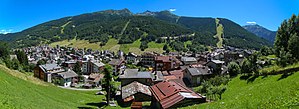
Brusson is a town and comune in Val d'Ayas, a left minor valley of the Aosta Valley region in Italy.

Sestriere (/se'strjɛre/) is a ski resort in Piedmont, Italy, a comune (municipality) of the Metropolitan City of Turin. It is situated in Val Susa, 17 km (11 mi) from the French border. Its name derives from Latin: ad petram sistrariam, that is at sixty Roman miles from Turin.

La Val is a comune (municipality) in the province of South Tyrol in northern Italy, located about 45 kilometres (28 mi) northeast of the city of Bolzano.

Bormio is a town and comune with a population of about 4,100 located in the Province of Sondrio, Lombardy region of the Alps in northern Italy.

Pragelato is a comune (municipality) in the Metropolitan City of Turin in the Italian region Piedmont, located about 60 kilometres (37 mi) west of Turin, in the upper Val Chisone. The name Pragelato, meaning "icy meadow", has been derived from the harsh climate and the fact that the ground is covered with ice for long periods. On both sides of the Chisone, extensive forests of pine and larch provide protection from the avalanches which are a common occurrence in the winter season: for this reason in the nineteenth century the people of Pragelato were only permitted to fell trees close to the mountain summits, and even then only with the permission of the communal administration.

Sauze d'Oulx is a town and comune in the Metropolitan City of Turin, Piedmont located 80 km from Turin in the Val di Susa, at the foot of Monte Genevris.

Badia is a comune (municipality) in South Tyrol, northern Italy. It is one of the five Ladin-speaking communities of the Val Badia which is part of the Ladinia region.
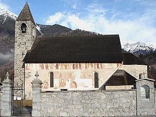
Pinzolo is a small town and comune situated in Val Rendena in Trentino in the northern Italian Alps at an elevation of 800 metres (2,600 ft). The Church of Saint Vigilius of Trent stands in the town.
Limone Piemonte is a comune (municipality) in the Province of Cuneo in the Italian region Piedmont, located about 100 kilometres (62 mi) south of Turin and about 20 kilometres (12 mi) south of Cuneo, on the border with France. As of September 2017, it had a population of 1,476 and an area of 71.3 square kilometres (27.5 sq mi).

Santa Cristina Gherdëina is a Ladin comune (municipality) in South Tyrol in northern Italy, located about 30 kilometres (19 mi) east of the city of Bolzano. Its Saslong ski run is home of the Super-G and Downhill for men races in FIS Ski World Cup.

Sëlva is a comune (municipality) in the Val Gardena in South Tyrol, northern Italy, located about 30 kilometres (19 mi) east of the city of Bolzano. The Ladin and Italian place names derive from the Latin word silva ("wood").
Canazei is a comune (municipality) in Trentino in the northern Italian region Trentino-Alto Adige/Südtirol, located in the upper part of the Val di Fassa, about 110 kilometres (68 mi) northeast of Trento. Its name derives from the Latin word cannicetus.

Tésero is a comune (municipality) in Trentino in the northern Italian region Trentino-Alto Adige/Südtirol, located in the Val di Fiemme about 40 kilometres (25 mi) northeast of Trento.
Frabosa Soprana is a comune (municipality) in the Province of Cuneo in the Italian region Piedmont, located about 90 kilometres (56 mi) south of Turin and about 25 kilometres (16 mi) southeast of Cuneo.

Frabosa Sottana is a comune (municipality) in the Province of Cuneo in the Italian region Piedmont, located about 90 kilometres (56 mi) south of Turin and about 20 kilometres (12 mi) southeast of Cuneo. The economy is based on winter tourism, based on the nearby ski resort of Prato Nevoso.

Chiesa in Valmalenco is a comune (municipality) in the Province of Sondrio in the Italian region Lombardy, located about 100 kilometres (62 mi) northeast of Milan and about 11 kilometres (7 mi) north of Sondrio, on the border with Switzerland. The English for "Chiesa in Valmalenco" is "Church in Valmalenco": it is the most important village of the Valmalenco valley . The area near Chiesa in Valmalenco is famous for alpine skiing and the particular geology of the surrounding mountains. As of 31 December 2004, it had a population of 2,714 and an area of 114.8 square kilometres (44.3 sq mi).
Villa di Tirano is a comune (municipality) in the Province of Sondrio in the Italian region Lombardy, located about 110 kilometres (68 mi) northeast of Milan and about 20 kilometres (12 mi) east of Sondrio, on the border with Switzerland. As of 31 December 2004, it had a population of 2,997 and an area of 24.6 square kilometres (9.5 sq mi).

Foppolo is a comune (municipality) in the Province of Bergamo in the Italian region of Lombardy, located about 120 kilometres (75 mi) northeast of Milan and about 60 kilometres (37 mi) north of Bergamo. As of 31 December 2004, it had a population of 206 and an area of 16.2 square kilometres (6.3 sq mi).

Piazzatorre is a comune (municipality) in the Province of Bergamo in the Italian region of Lombardy, located about 70 kilometres (43 mi) northeast of Milan and about 35 kilometres (22 mi) north of Bergamo. As of 31 December 2004, it had a population of 475 and an area of 23.6 square kilometres (9.1 sq mi).