Related Research Articles

The blizzard of 1977 hit Western New York and Southern Ontario's Niagara Peninsula from January 28 to February 1. Daily peak wind gusts ranging from 46 to 69 mph were recorded by the National Weather Service in Buffalo, with snowfall as high as 100 in (254 cm) recorded in areas, and the high winds blew this into drifts of 30 to 40 ft. There were 23 total storm-related deaths in Western New York, with five more in northern New York.

Dalwhinnie is a small village in the Scottish Highlands. Dalwhinnie is located at the head of Glen Truim and the north-east end of Loch Ericht, on the western edge of the Cairngorms National Park.
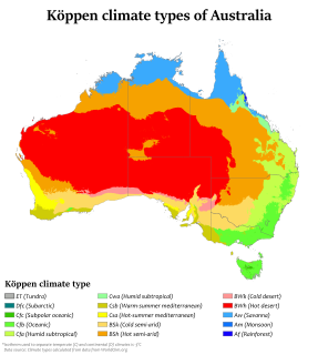
Australia's climate is governed mostly by its size and by the hot, sinking air of the subtropical high pressure belt. This moves north-west and north-east with the seasons. The climate is variable, with frequent droughts lasting several seasons, thought to be caused in part by the El Niño-Southern Oscillation. Australia has a wide variety of climates due to its large geographical size. The largest part of Australia is desert or semi-arid. Only the south-east and south-west corners have a temperate climate and moderately fertile soil. The northern part of the country has a tropical climate, varying between grasslands and desert. Australia holds many heat-related records: the continent has the hottest extended region year-round, the areas with the hottest summer climate, and the highest sunshine duration.
The winter of 1894–1895 was severe for the British Isles with a Central England temperature (CET) of 1.27 °C or 34.3 °F. Many climatologists have come to view this winter as the end of the Little Ice Age and the culmination of a decade of harsh winters in Britain. Whereas the average CET for the 10 winters from 1885–1886 to 1894–1895 was 2.87 °C or 37.2 °F, no winter with a CET under 3.0 °C or 37.4 °F followed for 22 years and no month as cold as February or January 1895 until 1940. In contrast, between 1659 and 1894, no spell with every winter CET above 3.0 °C or 37.4 °F had lasted longer than 12 winters.

The winter of 1946–1947 was a harsh European winter noted for its adverse effects in the United Kingdom. It caused severe hardships in economic terms and living conditions in a country still recovering from the Second World War. There were massive disruptions of energy supply for homes, offices and factories. Animal herds froze or starved to death. People suffered from the persistent cold, and many businesses shut down temporarily. When warm weather returned, the ice thawed and flooding was severe in most low-lying areas.
The year 2005 saw 25 heavy snowfall days, which is the joint snowiest year with 1876 across the United Kingdom, between the years 1861-2005.

The winter of 1990–91 was a particularly cold winter in Western Europe, noted especially for its effect on the United Kingdom, and for two significantly heavy falls of snow which occurred in December 1990 and February 1991. Sandwiched in between was a period of high winds and heavy rain which caused widespread damage. The winter was the coldest since January 1987, and the snowfall experienced in many parts of the United Kingdom would not be seen again until the snowfall of February 2009.

The winter of 2009–2010 in Europe was unusually cold. Globally, unusual weather patterns brought cold, moist air from the north. Weather systems were undergoing cyclogenesis from North American storms moving across the Atlantic Ocean to the west, and saw many parts of Europe experiencing heavy snowfall and record-low temperatures. This led to a number of deaths, widespread transport disruption, power failures and postponed sporting events.

The winter of 2009–10 in the United Kingdom was a meteorological event that started on 16 December 2009, as part of the severe winter weather in Europe. January 2010 was provisionally the coldest January since 1987 in the UK. A persistent pattern of cold northerly and easterly winds brought cold, moist air to the United Kingdom with many snow showers, fronts and polar lows bringing snowy weather with it.

The global storm activity of 2010 includes major meteorological events in the Earth's atmosphere during the year, including winter storms, hailstorms, out of season monsoon rain storms, extratropical cyclones, gales, microbursts, flooding, rainstorms, tropical cyclones, and other severe weather events.
Global storm activity of 2009 profiles the major worldwide storms, including blizzards, ice storms, and other winter events, from January 1, 2009, to December 31, 2009. Wintery storms are events in which the dominant varieties of precipitation are forms that only occur at cold temperatures, such as snow or sleet, or a rainstorm where ground temperatures are cold enough to allow ice to form. It may be marked by strong wind, thunder and lightning, heavy precipitation, such as ice, or wind transporting some substance through the atmosphere. Summer storms including flooding, severe thunderstorms and extratropical cyclones are also included in this list to a certain extent.
The winter of 2010–2011 in Europe began with an unusually cold November caused by a cold weather cycle that started in southern Scandinavia and subsequently moved south and west over both Belgium and the Netherlands on 25 November and into the west of Scotland and north east England on 26 November. This was due to a low pressure zone in the Baltics, with a high pressure over Greenland on 24 November, and ended in 3 May 2011 in Poland.
The winter of 2010–11 was a weather event that brought heavy snowfalls, record low temperatures, travel chaos and school disruption to the islands of Great Britain and Ireland. It included the United Kingdom's coldest December since Met Office records began in 1910, with a mean temperature of −1 °C (30 °F), breaking the previous record of 0.1 °C (32.2 °F) in December 1981. Also it was the second-coldest December in the narrower Central England Temperature (CET) record series which began in 1659, falling 0.1 °C short of the all-time record set in 1890. Although data has never officially been compiled, December 2010 is thought to be colder than December 1890 over the United Kingdom as a whole, as Scotland was up to 2 °C warmer than England. Hence, it is thought to be the coldest December across the UK as a whole since before 1659.

The December 1969 nor'easter was a strong winter storm that mainly affected the Northeastern United States and southern Quebec between December 25 and December 28, 1969. The multi-faceted storm system included a tornado outbreak, record snow accumulations, a damaging ice storm, and flooding rains.

The early 2012 European cold wave was a deadly cold wave that started on January 27, 2012, and brought snow and freezing temperatures to much of the European continent. There were more than 824 reported deaths in both Europe and North Africa. Particularly low temperatures hit several Eastern and Northern European countries, reaching as low as −42.7 °C (−44.9 °F) in Finland. The heaviest snow was recorded in the Balkan region. The cold weather was a result of an extensive area of very high pressure located over the north east of the continent in northern Russia, which circulated cold air from the east.

The 2013 extreme weather events included several all-time temperature records in Northern and Southern Hemisphere. The February extent of snow cover in Eurasia and North America was above average, while the extent of Arctic ice in the same month was 4.5% below the 1981–2010 average. The Northern Hemisphere weather extremes have been linked to the melting of Arctic sea ice, which alters atmospheric circulation in a way that leads to more snow and ice.
The Spring 2013 United Kingdom cold wave was a period of unusually cold weather in the United Kingdom between 6 March and early April 2013. The cold wave consisted of very low temperatures and significant snowfall. Freezing temperatures worsened due to the significant overcast and cloud covered skies. Extensive snowfall occurred on 11 and 12 March in the South East, North and West of England and Wales. Most parts of England, north Wales and the Isle of Man also suffered heavy persistent snowfall on 22 and 23 March 2013.

The March 2013 United Kingdom winter storm was an exceptional weather event that took place in the United Kingdom and Ireland on the night of 22–23 March 2013. Described as 'the worst snowfall for 30 years', the event brought chaos to many parts of Northern England, Northern Wales, Northern Ireland and Scotland. The worst places affected were North West England, North East Wales and Northern Ireland. Also accompanying the snow were very strong winds and very cold weather. At least two deaths were reported.
The Winter of 1985–1986 in Great Britain and Ireland contained two periods of notably cold weather. November 1985 brought an early start to winter with the month being the coldest in the Central England region since 1925, with an average temperature of 4.1 °C (39.4 °F). However, December was milder than average and January close to average before February became the coldest month of any kind since January 1963 with an average temperature of −1.1 °C (30.0 °F). March and April were also below average, especially April which was the coldest since 1922 with an average temperature of just 5.8 °C (42.4 °F).

The 2018–19 European winter occurred from late 2018 to early 2019. Notable events included the early snows in Spain and intense flooding in Italy, in cities such as Venice, the intense snow storms which affected central Europe in January, the snow storms in Greece over the New Year period, as well as the end of February. As well as severe winter weather, there was also exceptional warmth across western Europe in the last week of February. Parts of France had their warmest February day on record, with temperatures up to 28.1 °C (82.6 °F) at Eus on the 27th. Many places in the United Kingdom also broke temperature records, including the national record in Kew Gardens, at 21.2 °C (70.2 °F) on the 26th. Unlike previous winters, a developing El Niño was expected to influence weather patterns across Europe, although the affect is not fully known.
References
- 1 2 Floors, Rogier. "Reanalysis archives". www.wetterzentrale.de.
- 1 2 3 4 5 "British weather in April". www.trevorharley.com.