European windstorm

Last updated

24-hour animation of Cyclone Xynthia crossing France Xynthia animated small.gif
24-hour animation of Cyclone Xynthia crossing France

European windstorms are powerful extratropical cyclones which form as cyclonic windstorms associated with areas of low atmospheric pressure. They can occur throughout the year, but are most frequent between October and March, with peak intensity in the winter months. [1] Deep areas of low pressure are common over the North Atlantic, and occasionally start as nor'easters off the New England coast. They frequently track across the North Atlantic Ocean towards the north of Scotland and into the Norwegian Sea, which generally minimizes the impact to inland areas; however, if the track is further south, it may cause adverse weather conditions across Central Europe, Northern Europe and especially Western Europe. The countries most commonly affected include the United Kingdom, Ireland, the Netherlands, Norway, Germany, the Faroe Islands and Iceland. [2]

Contents

The strong wind phenomena intrinsic to European windstorms, that give rise to "damage footprints" at the surface, can be placed into three categories, namely the "warm jet", the "cold jet" and the "sting jet". These phenomena vary in terms of physical mechanisms, atmospheric structure, spatial extent, duration, severity level, predictability and location relative to cyclone and fronts. [3]

On average, these storms cause economic damage of around €1.9 billion per year and insurance losses of €1.4 billion per year (1990–1998). They cause the highest amount of natural catastrophe insurance loss in Europe. [4]

Cyclogenesis

North Atlantic Oscillation

Conceptual model for a European Windstorm and the associated strong wind "footprints". Storm track, footprint locations and footprint sizes vary by case, and that all footprints are not always present. European Windstorm Conceptual Model.jpg
Conceptual model for a European Windstorm and the associated strong wind "footprints". Storm track, footprint locations and footprint sizes vary by case, and that all footprints are not always present.

The state of the North Atlantic Oscillation relates strongly to the frequency, intensity, and tracks of European windstorms. [5] An enhanced number of storms have been noted over the North Atlantic region during positive NAO phases (compared to negative NAO phases) and is due to larger areas of suitable growth conditions. The occurrence of extreme North Atlantic cyclones is aligned with the NAO state during the cyclones' development phase. [6] The strongest storms are embedded within, and form in large scale atmospheric flow. [7] It should be kept in mind that, on the other hand, the cyclones themselves play a major role in steering the NAO phase. [6] Aggregate European windstorm losses show a strong dependence on NAO, [8] with losses increasing/decreasing 10-15% at all return periods. [8]

Connection to North American cold spells

A connection between wintertime cold air outbreaks in North America and European windstorms has been hypothesized in the last years.[ when? ] [9] [10] [11] [12] Cold spells over Central Canada and Eastern US appear to be associated with more frequent windstorms and flash floods over Iberia, whereas cold spells over Eastern Canada show a connection to windstorms over Northern Europe and the British Isles. [11] The reason behind those teleconnections is not fully clear yet, but changes in the behavior of the Polar jet stream are likely to be at least related to this effect. [9] [11]

Clustering

Temporal clustering of windstorm events has also been noted, with eight consecutive storms hitting Europe during the winter of 1989/90. Cyclones Lothar and Martin in 1999 were separated by only 36 hours. Cyclone Kyrill in 2007 followed only four days after Cyclone Per. [13] [14] In November 2011, Cyclone Berit moved across Northern Europe, and just a day later another storm, named Yoda, hit the same area.

Nomenclature

Naming of individual storms

Up to the second half of the 19th century, European windstorms were usually named either by the year, the date, or the Saint's day of their occurrence. [15] Although standardised naming schemes now exist, a storm may still be named differently in different countries. For instance, the Norwegian weather service also names independently notable storms that affect Norway, [16] which can result in multiple names being used in different countries they affect, such as:

In 2011, a social media campaign resulted in the storm officially called Cyclone Friedhelm being widely referred to as Hurricane Bawbag [17] [18] [19] and Hurricane Fannybaws. Such usage of the term Hurricane is not without precedent, as the 1968 Scotland storm was referred to as "Hurricane Low Q". [20]

UK and Ireland

2015 list of storm names from UK Met Office and Met Eireann Nameourstorms-names.jpg
2015 list of storm names from UK Met Office and Met Éireann

The UK Met Office and Ireland's Met Éireann held discussions about developing a common naming system for Atlantic storms. [21] [22] In 2015 a pilot project by the two forecasters was launched as "Name our storms" which sought public participation in naming large-scale cyclonic windstorms affecting the UK and/or Ireland over the winter of 2015/16. [23] [24] The UK/Ireland storm naming system began its first operational season in 2015/2016, with Storm Abigail. [25] [ circular reference ]

Germany

During 1954, Karla Wege, a student at the Free University of Berlin's meteorological institute suggested that names should be assigned to all areas of low and high pressure that influenced the weather of Central Europe. [26] The university subsequently started to name every area of high or low pressure within its weather forecasts, from a list of 260 male and 260 female names submitted by its students. [26] [27] The female names were assigned to areas of low pressure while male names were assigned to areas of high pressure. [26] [27] The names were subsequently exclusively used by Berlin's media until February 1990, after which the German media started to commonly use the names, however, they were not officially approved by the German Meteorological Service Deutscher Wetterdienst. [26] [28] The DWD subsequently banned the usage of the names by their offices during July 1991, after complaints had poured in about the naming system. [27] However, the order was leaked to the German press agency, Deutsche Presse-Agentur, who ran it as its lead weather story. [27] Germany's ZDF television channel subsequently ran a phone in poll on 17 July 1991 and claimed that 72% of the 40,000 responses favored keeping the names. [27] This made the DWD pause and think about the naming system and these days the DWD accept the naming system and request that it is maintained. [27] [28]

During 1998 a debate started about whether it was discriminatory to name areas of high pressure with male names and the areas of low pressure with female names. [26] The issue was subsequently resolved by alternating male and female names each year. [26] In November 2002 the "Adopt-a-Vortex" scheme began, which allows members of the public or companies to buy naming rights for a letter chosen by the buyer that are then assigned alphabetically to high and low pressure areas in Europe during each year. [29] The naming comes with the slim chance that the system will be notable. The money raised by this is used by the meteorology department to maintain weather observations at the Free University. [30]

Names are listed alphabetically beginning in January. [31]

Name of phenomena

Satellite picture of Cyclone Ulli on 3 January 2012 Ulli January 3 2012.png
Satellite picture of Cyclone Ulli on 3 January 2012

Several European languages use cognates of the word huracán (ouragan, uragano, orkan, huragan, orkaan, ураган, which may or may not be differentiated from tropical hurricanes in these languages) to indicate particularly strong cyclonic winds occurring in Europe. The term hurricane as applied to these storms is not in reference to the structurally different tropical cyclone of the same name, but to the hurricane strength of the wind on the Beaufort scale (winds ≥ 118 km/h or ≥ 73 mph).

In English, use of term hurricane to refer to European windstorms is mostly discouraged, as these storms do not display the structure of tropical storms. Likewise the use of the French term ouragan is similarly discouraged as hurricane is in English, as it is typically reserved for tropical storms only. [32] [33] European windstorms in Latin Europe are generally referred to by derivatives of tempestas (tempest, tempête, tempestado, tempesta), meaning storm, weather, or season, from the Latin tempus, meaning time. [34]

Globally storms of this type forming between 30° and 60° latitude are known as extratropical cyclones. The name European windstorm reflects that these storms in Europe are primarily notable for their strong winds and associated damage, which can span several nations on the continent. The strongest cyclones are called windstorms within academia and the insurance industry. [2] The name European windstorm has not been adopted by the UK Met Office in broadcasts (though it is used in their academic research [35] ), the media or by the general public, and appears to have gained currency in academic and insurance circles as a linguistic and terminologically neutral name for the phenomena.

In contrast to some other European languages there is a lack of a widely accepted name for these storms in English. The Met Office and UK media generally refer to these storms as severe gales. [36] The current definition of severe gales (which warrants the issue of a weather warning) are repeated gusts of 70 mph (110 km/h) or more over inland areas. [36] European windstorms are also described in forecasts variously as winter storms, [37] winter lows, autumnal lows, Atlantic lows and cyclonic systems.[ citation needed ] They are also sometimes referred to as bullseye isobars and dartboard lows in reference to their appearance on weather charts.[ citation needed ] A Royal Society exhibition has used the name European cyclones, [38] with North-Atlantic cyclone and North-Atlantic windstorms also being used. [2] Though with the advent of the "Name our Storms" project, they are generally known as storms.

Economic impact

A fictitious synoptic chart of an extratropical cyclone affecting Great Britain & Ireland. The blue and red arrows between isobars indicate the direction of the wind and its relative temperature, while the "L" symbol denotes the center of the "low". Note the occluded cold and warm frontal boundaries. Uk-cyclone-2.png
A fictitious synoptic chart of an extratropical cyclone affecting Great Britain & Ireland. The blue and red arrows between isobars indicate the direction of the wind and its relative temperature, while the "L" symbol denotes the center of the "low". Note the occluded cold and warm frontal boundaries.

Insurance losses

Insurance losses from windstorms are the second greatest source of loss for any natural peril after Atlantic hurricanes in the United States. [39] Windstorm losses exceed those caused by flooding in Europe. For instance one windstorm, Kyrill in 2007, exceeded the losses of the 2007 United Kingdom floods. [40] On average, some 200,000 buildings are damaged by high winds in the UK every year. [41]

Damaged pylon in Germany after Windstorm Kyrill 2007 Strommast.JPG
Damaged pylon in Germany after Windstorm Kyrill 2007

Energy supplies

European windstorms wipe out electrical generation capacity across large areas, making supplementation from abroad difficult (windturbines shut down to avoid damage and nuclear capacity may shut if cooling water is contaminated or flooding of the power plant occurs). Transmission capabilities can also be severely limited if power lines are brought down by snow, ice or high winds. In the wake of Cyclone Gudrun in 2005 Denmark and Latvia had difficulty importing electricity, [42] and Sweden lost 25% of its total power capacity as the Ringhals Nuclear Power Plant and Barsebäck nuclear power plant nuclear plants were shut down. [43]

During the Boxing Day Storm of 1998 the reactors at Hunterston B nuclear power station were shut down when power was lost, possibly due to arcing at pylons caused by salt spray from the sea. [44] When the grid connection was restored, the generators that had powered the station during the blackout were shut down and left on "manual start", so when the power failed again the station was powered by batteries for a short time of around 30 minutes, until the diesel generators were started manually. [44] During this period the reactors were left without forced cooling, in a similar fashion to the Fukushima Daiichi nuclear disaster, but the event at Hunterston was rated as International Nuclear Event Scale 2. [44] [45]

A year later in 1999 during the Lothar storm Flooding at the Blayais Nuclear Power Plant resulted in a "level 2" event on the International Nuclear Event Scale. [46] Cyclone Lothar and Martin in 1999 left 3.4 million customers in France without electricity, and forced Électricité de France to acquire all the available portable power generators in Europe, with some even being brought in from Canada. [43] These storms brought a fourth of France's high-tension transmission lines down and 300 high-voltage transmission pylons were toppled. It was one of the greatest energy disruptions ever experienced by a modern developed country. [47]

Following the Great Storm of 1987 the High Voltage Cross-Channel Link between the UK and France was interrupted, and the storm caused a domino-effect of power outages throughout the Southeast of England. [48] Conversely windstorms can produce too much wind power. Cyclone Xynthia hit Europe in 2010, generating 19000 megawatts of electricity from Germany's 21000 wind turbines. The electricity produced was too much for consumers to use, and prices on the European Energy Exchange in Leipzig plummeted, which resulted in the grid operators having to pay over 18 euros per megawatt-hour to offload it, costing around half a million euros in total. [49]

Disruption of the gas supply during Cyclone Dagmar in 2011 left Royal Dutch Shell's Ormen Lange gas processing plant in Norway inoperable after its electricity was cut off by the storm. This left gas supplies in the United Kingdom vulnerable as this facility can supply up to 20 per cent of the United Kingdom's needs via the Langeled pipeline. However, the disruption came at a time of low demand. [50] The same storm also saw the Leningrad Nuclear Power Plant also affected, as algae and mud stirred up by the storm were sucked into the cooling system, resulting in one of the generators being shut down. [51] [52] A similar situation was reported in the wake of Storm Angus in 2016 (though not linked specifically to the storm) when reactor 1 at Torness Nuclear Power Station in Scotland was taken offline after a sea water intake tripped due to excess seaweed around the inlet. [53] Also following Storm Angus the UK's National Grid launched an investigation into whether a ship's anchor damaged four of the eight cables of the Cross Channel high voltage interconnector, which would leave it only able to operate at half of its capacity until February 2017. [54]

Notable windstorms

Historic windstorms

Contemporary picture of the flood that struck the North Sea coast of Germany and Denmark in October 1634. Die erschreckliche Wasser-Fluth (Burchardiflut 1634, Stich).jpg
Contemporary picture of the flood that struck the North Sea coast of Germany and Denmark in October 1634.

Severe storms since 1950

Most intense storms

Most intense extratropical cyclones in the North Atlantic
RankDateNameMinimum pressure [62] Reported location
1January 1993 Braer Storm 914 hectopascals (27.0 inHg)Between Iceland and Great Britain
2December 1986Unnamed916 hectopascals (27.0 inHg)South-east of Greenland
3January 1839 Night of the Big Wind 918 hectopascals (27.1 inHg) [63] Off the coast of Great Britain
4December 1989Unnamed920 hectopascals (27 inHg)South-west of Iceland
February 2020 Storm Dennis South of Iceland
6February 1870Unnamed921.1 hectopascals (27.20 inHg)South-west of Iceland
7February 1824Unnamed924 hectopascals (27.3 inHg) Reykjavik, Iceland
8December 1929Unnamed925.5 hectopascals (27.33 inHg) Atlantic Ocean
9January 1884Unnamed925.6 hectopascals (27.33 inHg) Ochtertyre, Great Britain
10March 1992Unnamed926 hectopascals (27.3 inHg)Off Newfoundland

See also

European windstorm seasons

Related Research Articles

<span class="mw-page-title-main">Burns' Day Storm</span> 1990 January storm in Northwestern Europe

The Burns' Day Storm was an extremely violent windstorm that took place on 25–26 January 1990 over North-Western Europe. It is one of the strongest European windstorms on record and caused many fatalities in the UK and Europe. This storm has received different names, as there was no official list of such events in Europe at the time. Starting on Burns Day, the birthday of the Scottish poet Robert Burns, it caused widespread damage and hurricane-force winds over a wide area.

<span class="mw-page-title-main">Cyclone Lothar</span> 1999 windstorm in Western Europe

Cyclone Lothar is regarded as the worst European windstorm recorded during the 20th century. Crossing France, Belgium, Luxembourg and Germany between 25 December and 27 December 1999, Cyclone Lothar resulted in 110 fatalities and more than €15 billion in damage, becoming the costliest European windstorm ever recorded.

<span class="mw-page-title-main">Cyclone Anatol</span> Cyclone

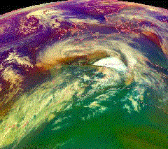
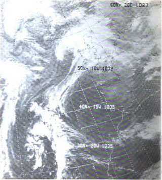
Anatol is the name given by the Free University of Berlin to a powerful winter storm that hit Denmark, Southwest Sweden, and Northern Germany on 3 December 1999. The storm had sustained winds of 146 km/h and wind gusts of up to 184 km/h, equivalent to an intense category 1 hurricane, which is unusually strong for storms in northern Europe. The storm caused 20 fatalities; in Denmark alone 7 died and more than 800 were injured.

A superstorm is a large, unusually occurring, destructive storm without another distinct meteorological classification, such as hurricane or blizzard.

<span class="mw-page-title-main">Extratropical cyclone</span> Type of cyclone

Extratropical cyclones, sometimes called mid-latitude cyclones or wave cyclones, are low-pressure areas which, along with the anticyclones of high-pressure areas, drive the weather over much of the Earth. Extratropical cyclones are capable of producing anything from cloudiness and mild showers to severe gales, thunderstorms, blizzards, and tornadoes. These types of cyclones are defined as large scale (synoptic) low pressure weather systems that occur in the middle latitudes of the Earth. In contrast with tropical cyclones, extratropical cyclones produce rapid changes in temperature and dew point along broad lines, called weather fronts, about the center of the cyclone.

<span class="mw-page-title-main">Severe weather</span> Any dangerous meteorological phenomenon

Severe weather is any dangerous meteorological phenomenon with the potential to cause damage, serious social disruption, or loss of human life. Types of severe weather phenomena vary, depending on the latitude, altitude, topography, and atmospheric conditions. High winds, hail, excessive precipitation, and wildfires are forms and effects of severe weather, as are thunderstorms, downbursts, tornadoes, waterspouts, tropical cyclones, and extratropical cyclones. Regional and seasonal severe weather phenomena include blizzards (snowstorms), ice storms, and duststorms.

The following outline is provided as an overview of and topical guide to tropical cyclones:

<span class="mw-page-title-main">Cyclone Martin (1999)</span> Storm in Europe December 1999

Cyclone Martin was an extremely violent European windstorm which crossed southern Europe on 27–28 December 1999, causing severe damage across France, Spain, Switzerland and Italy one day after Cyclone Lothar had affected more northerly areas. Wind speeds reached around 200 km/h (120 mph) in French department of Charente-Maritime. The storm caused 30 fatalities and €6 billion in damages. Combined with Lothar, Cyclone Martin is often referred to as the Storm of the Century in western and central Europe.

<span class="mw-page-title-main">Hurricane Bawbag</span> Storm in Scotland in 2011

Hurricane Bawbag, also known as Cyclone Friedhelm was an intense extratropical cyclone which brought hurricane-force winds to Scotland at the beginning of December 2011. The storm also brought prolonged gales and rough seas to the rest of the British Isles, as well as parts of Scandinavia. On 8 December, winds reached up to 165 mph (266 km/h) at elevated areas, with sustained wind speeds of up to 80 mph (130 km/h) reported across populous areas. The winds uprooted trees and resulted in the closure of many roads, bridges, schools and businesses. Overall, the storm was the worst to affect Scotland in 10 years, though a stronger storm occurred less than a month afterwards, on 3 January 2012. Although the follow-up storm was more intense, the winter of 2011–12 is usually remembered for Bawbag among Scots.

<span class="mw-page-title-main">Cyclone Hergen</span> European windstorm, December 2011

Cyclone Hergen was an intense European windstorm that moved across Northern Europe during mid December 2011. It was first noted over the central North Atlantic Ocean by the Met Office. It then later reached peak intensity just northwest of Ireland and then crossed the north of Scotland hours later. It hung around the coast of Norway for the next week before being absorbed by another strong windstorm named Joachim.

<span class="mw-page-title-main">Cyclone Ulli</span>

Cyclone Ulli was an intense European windstorm. Forming on December 31, 2011 off the coast of New Jersey, Ulli began a rapid strengthening phase on January 2 as it sped across the Atlantic. Ulli was the costliest disaster in January 2012 globally. The damage from the storm in Glasgow was also compared to a storm in 1968.

<span class="mw-page-title-main">Gale of January 1976</span> Extratropical cyclone and storm surge which occurred over January 1976

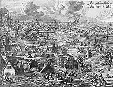
The Gale of January 1976, widely known as the "Capella" storm in Germany and the Ruisbroek flood in Belgium, was one in a series of extratropical cyclones and storm surges, which occurred over January 1976. The gale of 2–5 January 1976 resulted in severe wind damage across western and central Europe and coastal flooding around the southern North Sea coasts. At the time, this was the most severe storm of the century over the British Isles. Total fatalities reached 82 across Europe, although a figure of 100 is given by the World Meteorological Organization. Of these 24 were reported in Britain and 4 in Ireland. Overall losses of US$1.3 billion were incurred, with insured losses standing at US$500 million (1976).

<span class="mw-page-title-main">Cyclone Jeanett</span> Extratropical cyclone

Storm Jeanett was a strong extratropical cyclone and European windstorm which affected much of northwest Europe on 27–28 October 2002. The storm brought strong winds and heavy rainfall, with wind speeds reaching up to 180 km/h uprooting trees, smashing cars and damaging buildings. The storm was responsible for a total of 33 deaths across Europe, including Britain, the Netherlands, France, Austria, Belgium, Denmark, Poland, Switzerland and Sweden. The majority of the fatalities were caused by falling trees.

<span class="mw-page-title-main">Weather system naming in Europe</span> Overview of storm naming in Europe

Weather system naming in Europe follows several multinational schemes under the EUMETNET framework. On the north Atlantic coast, the United Kingdom's Met Office, in collaboration with its Irish counterpart Met Éireann and, since 2019, its Dutch counterpart the Royal Netherlands Meteorological Institute (KNMI), decided to introduce a storm naming system following the St Jude's day storm on 27–28 October 2013 which caused 17 deaths in Europe and the 2013–14 Atlantic winter storms in Europe to give a single, authoritative naming system to prevent confusion with the media and public using different names for the same storms. The first European windstorm to be named was Abigail on 10 November 2015. The definitive list is combined from suggestions from the three countries.

<span class="mw-page-title-main">Cyclone Tini</span> 2014 European windstorm

Storm Darwin a European windstorm that Western Europe, particularly Ireland and the United Kingdom on 12 February 2014. The storm brought hurricane-force winds to Ireland the with the Met Office and Met Éireann describing the storm as one of the most significant to affect Ireland, Wales and West England in recent decades. Tini was one of the strongest storms of the 2013–2014 Atlantic winter storms in Europe, and also brought heavy across the UK and Ireland exacerbating the 2013–2014 United Kingdom winter floods, and may have been the most damaging storm of the period.

The 2017–2018 European windstorm season was the third instance of seasonal European windstorm naming. France, Spain and Portugal took part in winter storm naming for the first time this season.

<span class="mw-page-title-main">Cyclone Egon</span> 2017 European windstorm

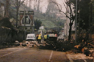
Cyclone Egon was a European windstorm that affected the north of France, Belgium and Germany during the night of Thursday 12 to Friday 13 January 2017. It caused three deaths, widespread power outages, and wind damage and significant snowfall, primarily France and Germany, but also in the Benelux states, Austria and Switzerland.

References

  1. Sabbatelli, Tanja Dallafior Michèle Lai Tom. "European Windstorm: The Name Game | The RMS Blog" . Retrieved 16 February 2020.
  2. 1 2 3 Martínez-Alvarado, Oscar; Suzanne L Gray; Jennifer L Catto; Peter A Clark (10 May 2012). "Sting jets in intense winter North-Atlantic windstorms". Environmental Research Letters. 7 (2): 024014. Bibcode:2012ERL.....7b4014M. doi: 10.1088/1748-9326/7/2/024014 .
  3. 1 2 Hewson, Tim D.; Neu, URS (1 January 2015). "Cyclones, windstorms and the IMILAST project". Tellus A. 67 (1): 27128. Bibcode:2015TellA..6727128H. doi: 10.3402/tellusa.v67.27128 .
  4. "Direct losses from weather disasters". European Environment Agency. Retrieved 16 February 2020.
  5. Magnusdottir, Gudrun; Clara Deser; R. Saravanan (2004). "The Effects of North Atlantic SST and Sea Ice Anomalies on the Winter Circulation in CCM3. Part I: Main Features and Storm Track Characteristics of the Response". Journal of Climate. 17 (5): 857–876. Bibcode:2004JCli...17..857M. doi:10.1175/1520-0442(2004)017<0857:TEONAS>2.0.CO;2. S2CID   18235556.
  6. 1 2 Donat, Markus G. (March 2010). "European wind storms, related loss potentials and changes in multi-model climate simulations" (PDF). Dissertation, FU Berlin. Retrieved 19 February 2012.
  7. Hanley, John; Caballero, Rodrigo (November 2012). "The role of large-scale atmospheric flow and Rossby wave breaking in the evolution of extreme windstorms over Europe" (PDF). Geophysical Research Letters. 39 (21): L21708. Bibcode:2012GeoRL..3921708H. doi: 10.1029/2012GL053408 . Retrieved 27 December 2012.
  8. 1 2 "Impact of North Atlantic Oscillation on European Windstorms" (PDF). Willis Research Network. Retrieved 26 December 2012.
  9. 1 2 Messori, Gabriele; Caballero, Rodrigo; Gaetani, Marco (28 June 2016). "On cold spells in North America and storminess in western Europe: Cold Spells and Storminess". Geophysical Research Letters. 43 (12): 6620–6628. doi: 10.1002/2016GL069392 . S2CID   132347732.
  10. De Luca, P.; Messori, G.; Pons, F. M. E.; Faranda, D. (April 2020). "Dynamical systems theory sheds new light on compound climate extremes in Europe and Eastern North America". Quarterly Journal of the Royal Meteorological Society. 146 (729): 1636–1650. Bibcode:2020QJRMS.146.1636D. doi:10.1002/qj.3757. ISSN   0035-9009. S2CID   210625859.
  11. 1 2 3 Leeding, Richard; Riboldi, Jacopo; Messori, Gabriele (1 March 2023). "On Pan-Atlantic cold, wet and windy compound extremes". Weather and Climate Extremes. 39: 100524. Bibcode:2023WCE....3900524L. doi: 10.1016/j.wace.2022.100524 . ISSN   2212-0947.
  12. Messori, Gabriele; Faranda, Davide (16 April 2023). "On the Systematic Occurrence of Compound Cold Spells in North America and Wet or Windy Extremes in Europe". Geophysical Research Letters. 50 (7): e2022GL101008. Bibcode:2023GeoRL..5001008M. doi: 10.1029/2022GL101008 . ISSN   0094-8276. S2CID   257870356.
  13. AIR Worldwide: European Windstorms: Implications of Storm Clustering on Definitions of Occurrence Losses Archived 23 January 2016 at the Wayback Machine
  14. "European Windstorm Clustering Briefing Paper" (PDF). Archived from the original (PDF) on 26 April 2012. Retrieved 25 November 2011.
  15. "Who, What, Why: How are hurricanes named?". BBC News. BBC. 5 September 2011. Retrieved 14 February 2012.
  16. "List of named extreme weathers in Norway". Meteolorologisk instituut. Archived from the original on 3 January 2008. Retrieved 13 March 2010.
  17. "How internet sensation Hurricane Bawbag helped Scotland conquer the world". Daily Record. Scotland. 9 December 2011. Retrieved 13 January 2012.
  18. STEPHEN MCGINTY (9 December 2011). "Would Bawbag's proud progenitor please stand up and take a bow - Cartoon". The Scotsman. Retrieved 13 January 2012.
  19. "Scots slang highlighted after country is battered by Hurricane Bawbag". Daily Record. 10 December 2011. Retrieved 13 December 2011.
  20. Mr. Edward Heath, MP Bexley (7 February 1968). "Scotland (Storm Damage)". Parliamentary Debates (Hansard) . House of Commons.
  21. Ahlstrom, Dick (15 January 2015). "Storm-naming system yet to be put in place as Rachel peters out". The Irish Times. Retrieved 17 January 2015.
  22. "Met Éireann plans to start naming storms from next year". The Journal. 21 December 2014. Retrieved 17 January 2015.
  23. "Name our storms". Met Office. 19 October 2015. Retrieved 20 October 2015.
  24. "Met Éireann and the UK Met Office release list of winter storm names". Met Éireann. 20 October 2015. Retrieved 20 October 2015.
  25. Storm Abigail
  26. 1 2 3 4 5 6 "History of Naming Weather Systems". The Free University of Berlin's Institute of Meteorology. January 2000. Archived from the original on 29 November 2014. Retrieved 17 August 2014.
  27. 1 2 3 4 5 6 Gutman, Roy. "Germany bans naming storms 'mean Irene' after howls of protest". Ottawa Citizen. p. F10.  via Lexis Nexis (subscription required)
  28. 1 2 "Geschichte der Namensvergabe" [History of Naming Weather Systems]. The Free University of Berlin's Institute of Meteorology. January 2000. Archived from the original on 17 August 2014. Retrieved 17 August 2014.
  29. "European Cold Front 'Cooper' Sponsored by Mini". Der Spiegel. 31 January 2012. Retrieved 2 February 2012.
  30. "European Windstorms and the North Atlantic Oscillation: Impacts, Characteristics, and Predictability". RPI Series No. 2, Risk Prediction Initiative/Bermuda Biological Station for Research, Hamilton, Bermuda. 1999. Archived from the original on 15 August 2010. Retrieved 25 November 2011.
  31. "Wetterpatenschaft - Home". 2 October 2019. Archived from the original on 27 February 2007. Retrieved 13 March 2010.
  32. "Pas d'ouragan possible en France, mais des tempêtes comparables à Sandy". 20 Minutes. 30 October 2012. Retrieved 6 January 2013.
  33. "L'OUEST BALAYÉ PAR UN OURAGAN DÉVASTATEUR". alertes-meteo.com. Retrieved 6 January 2013.
  34. American Heritage Dictionary
  35. "XWS: a new historical catalogue of extreme european windstorms" (PDF). Met Office. Retrieved 13 July 2013.
  36. 1 2 Baker, Chris; Brian Lee (2008). "Guidance on Windstorms for the Public Health Workforce". Chemical Hazards and Poisons Report (13): 49–52. Archived from the original on 23 May 2012. Retrieved 6 June 2012.
  37. "Extratropical Cyclones (Winter Storms)". AIR worldwide. Archived from the original on 1 February 2012. Retrieved 6 February 2012.
  38. "Damaging winds from European cyclones". Royal Society. Retrieved 22 April 2012.
  39. "Europe Windstorm" (PDF). RMS. Archived from the original (PDF) on 2 March 2014. Retrieved 21 February 2013.
  40. Doll, Claus; Sieber, N. (2010). "Climate and Weather Trends in Europe. Annex 1 to Deliverable 2: Transport Sector Vulnerabilities within the research project WEATHER (Weather Extremes: Impacts on Transport Systems and Hazards for European Regions) funded under the 7th framework program of the European Commission" (PDF). Archived from the original (PDF) on 5 March 2016. Retrieved 20 January 2013.{{cite journal}}: Cite journal requires |journal= (help)
  41. "The vulnerability of UK property to windstorm damage". Association of British Insurers. Retrieved 10 February 2013.[ permanent dead link ]
  42. "Impacts of winter storm Gudrun of 7th –9th January 2005 and measures taken in Baltic Sea Region" (PDF). astra project. Archived from the original (PDF) on 5 February 2018. Retrieved 17 February 2012.
  43. 1 2 3 "Impacts of Severe Storms on Electric Grids" (PDF). Union of the Electricity Industry – EURELECTRIC. 2006. Archived from the original (PDF) on 21 September 2013. Retrieved 5 January 2013.
  44. 1 2 3 "Nuclear power station loss of electricity grid during severe storm (1998)" (PDF). safetyinengineering.com. Archived from the original (PDF) on 28 February 2021. Retrieved 20 December 2013.
  45. "UK Nuclear alert at Scottish plant". BBC News. 30 December 1998. Retrieved 20 December 2013.
  46. COMMUNIQUE N°7 – INCIDENT SUR LE SITE DU BLAYAIS Archived 27 May 2013 at the Wayback Machine ASN, published 30 December 1999. Retrieved 22 March 2011
  47. 1 2 Tatge, Yörn. "Looking Back, Looking Forward: Anatol, Lothar and Martin Ten Years Later". Air-Worldwide. Retrieved 30 May 2013.
  48. Burt, S. D.; Mansfield, D. A. (1988). "The Great Storm of 15-16 October 1987". Weather. 43 (3): 90–108. Bibcode:1988Wthr...43...90B. doi:10.1002/j.1477-8696.1988.tb03885.x.
  49. "Smart Grid: Solving the Energy Puzzle" (PDF). T-Systems customer magazine, Best Practice. Retrieved 13 March 2013.
  50. "UK gas supplies choppy after North Sea storm". Reuters. 27 December 2011. Retrieved 17 May 2012.
  51. "Myrsky sulki generaattorin venäläisvoimalassa" (in Finnish). yle.fi. 28 December 2011. Retrieved 14 February 2012.
  52. "Generator stängd vid Sosnovij Bor" (in Swedish). hbl.fi. Archived from the original on 8 December 2015. Retrieved 14 February 2012.
  53. Hannan, Martin (23 November 2016). "Storms batter Scotland as reactor at Torness nuclear plant shuts down". The National. Retrieved 29 November 2016.
  54. Ward, Andrew (29 November 2016). "UK grid loses half the power from link to France". Financial Times. Retrieved 29 November 2016.
  55. "The Tay Bridge Disaster" . Retrieved 3 September 2007.
  56. Eden, Philip. "THE SHEFFIELD GALE OF 1962" (PDF). Royal Meteorological Society. Retrieved 1 February 2022.
  57. "Storms European scale". European Centre for Climate Adaptation. Retrieved 28 February 2013.
  58. "1999 Windstorm naming lists". FU-Berlin. January 2000. Archived from the original on 7 September 2017. Retrieved 9 December 2011.
  59. "2007 Windstorm naming lists". FU-Berlin. January 2000. Archived from the original on 20 April 2012. Retrieved 9 December 2011.
  60. "2010 Windstorm naming lists". FU-Berlin. January 2000. Archived from the original on 7 September 2017. Retrieved 9 December 2011.
  61. At least 50 dead in western Europe storms
  62. Burt, Stephen (2007). "The Lowest of the Lows … extremes of barometric pressure in the British Isles, part 1 – the deepest depressions". Weather. 62 (1): 4–14. Bibcode:2007Wthr...62....4B. doi:10.1002/wea.20. ISSN   1477-8696. S2CID   120748945.
  63. Shields, Lisa; Fitzgerald, Denis (1989). "The 'Night of the Big Wind' in Ireland, 6–7 January 1839" (PDF). Irish Geography. 22 (1): 31–43. doi:10.1080/00750778909478784. S2CID   129732231. Archived from the original (PDF) on 4 March 2016. Retrieved 15 February 2020.