
A blizzard is a severe snowstorm characterized by strong sustained winds and low visibility, lasting for a prolonged period of time—typically at least three or four hours. A ground blizzard is a weather condition where snow is not falling but loose snow on the ground is lifted and blown by strong winds. Blizzards can have an immense size and usually stretch to hundreds or thousands of kilometres.

A nor'easter, or an East Coast low is a synoptic-scale extratropical cyclone in the western North Atlantic Ocean. The name derives from the direction of the winds that blow from the northeast. The original use of the term in North America is associated with storms that impact the upper north Atlantic coast of the United States and the Atlantic Provinces of Canada.
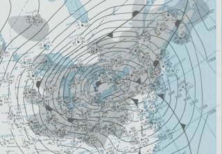
The Great Blizzard of 1978 was a historic winter storm that struck the Ohio Valley and Great Lakes regions of the United States as well as Southern Ontario in Canada from Wednesday, January 25 through Friday, January 27, 1978. It is often cited as one of the most severe blizzards in US history. The third lowest non-tropical atmospheric pressure ever recorded in the mainland United States occurred as the storm passed over Mount Clemens, Michigan, where barometer readings fell to 956.0 mb (28.23 inHg) on January 26.
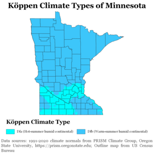
Minnesota has a humid continental climate, with hot summers and cold winters. Minnesota's location in the Upper Midwest allows it to experience some of the widest variety of weather in the United States, with each of the four seasons having its own distinct characteristics. The area near Lake Superior in the Minnesota Arrowhead region experiences weather unique from the rest of the state. The moderating effect of Lake Superior keeps the surrounding area relatively cooler in the summer and warmer in the winter, giving that region a smaller yearly temperature variation. On the Köppen climate classification, much of the southern third of Minnesota—roughly from the Twin Cities region southward—falls in the hot summer zone (Dfa), and the northern two-thirds of Minnesota falls in the warm summer zone (Dfb).

A Gulf low or Texas Low is a low pressure area that forms or intensifies over the Gulf of Mexico and move northeast on the western side of the Appalachian mountains and sometimes on the Atlantic coast to become a nor'easter. Because they move from over or near the Gulf of Mexico, these storm systems are capable of transporting copious amounts of moisture with them. At their strongest, these storm systems are even more potent snowfall producers than panhandle hooks, primarily because of the mixing of Atlantic Ocean moisture into the storm system once they cross the Appalachian Mountains. Because of the general west to east movement of weather systems in the mid latitudes of the northern hemisphere, Gulf Lows rarely affect areas west of the Mississippi River. One such exception was the Halloween Blizzard of 1991.
The December 2009 Midwest blizzard was a powerful extratropical cyclone which was of a category which meteorologists refer to as a cyclogenic bomb, a system which shows a drop in central pressure similar to the rapid intensification cycle of a tropical cyclone, more than 1 mbar per hour for 12 to 24 hours or more. A sustained drop averaging more than 2.5 mbar/h is termed explosive deepening/intensification, and this was the case with this rapidly deepening and intensifying storm as it traversed the Midwest and Ontario and on to Québec, Greenland and vicinity. In many locations wind, snowfall, and precipitation moisture content records dating back to the December 2, 1990 storm, the 1976-1978 period, the 1949 blizzard, or even further back were broken, with barometric pressure records falling as well. Both the central pressure (depth) and rate of change and differential over a given distance (intensity) were remarkable, and both caused hurricane-force winds in places.
Global storm activity of 2008 profiles the major worldwide storms, including blizzards, ice storms, and other winter events, from January 1, 2008 to December 31, 2008. A winter storm is an event in which the dominant varieties of precipitation are forms that only occur at cold temperatures, such as snow or sleet, or a rainstorm where ground temperatures are cold enough to allow ice to form. It may be marked by strong wind, thunder and lightning, heavy precipitation, such as ice, or wind transporting some substance through the atmosphere. Major dust storms, Hurricanes, cyclones, tornados, gales, flooding and rainstorms are also caused by such phenomena to a lesser or greater existent.

A Colorado low is a low-pressure area that forms in southeastern Colorado or northeastern New Mexico, typically in the winter. After forming, the system moves across the Great Plains. Colorado lows can produce heavy wintry precipitation, and have a general east to northeast movement, impacting regions as far north as Winnipeg and as far east as the Atlantic coast. If upper-level conditions are right, the jet stream can push the low farther south, bringing wintry precipitation as far as Texas. When pushed this far south, the system is often referred to as a "blue norther". On the more typical track, a Colorado low can be similar to an Alberta clipper. In the winter Colorado lows are responsible for a majority of the snow that the Midwest receives; however, summer systems can trigger long-lasting convective systems, including severe weather. Spring and early summer Colorado low cyclogenesis can result in significant tornado outbreaks over the Great Plains and Midwest.

The February 2013 North American blizzard, also known as Winter Storm Nemo and the Blizzard of 2013, was a powerful blizzard that developed from the combination of two areas of low pressure, primarily affecting the Northeastern United States and parts of Canada, causing heavy snowfall and hurricane-force winds. The storm crossed the Atlantic Ocean, affecting Ireland and the United Kingdom. The nor'easter's effects in the United States received a Category 3 rank on the Northeast Snowfall Impact Scale, classifying it as a "Major" Winter Storm.

The 2013–14 North American winter was one of the most significant for the United States, due in part to the breakdown of the polar vortex in November 2013, which allowed very cold air to travel down into the United States, leading to an extended period of very cold temperatures. The pattern continued mostly uninterrupted throughout the winter and numerous significant winter storms affected the Eastern United States, with the most notable one being a powerful winter storm that dumped ice and snow in the Southeast and Northeast in mid-February. Most of the cold weather abated by the end of March, though a few winter storms did affect the western portions of the U.S. towards the end of the winter.

The 2014–15 North American winter was frigid and prolifically wintry, especially across the eastern half of North America in the months of January–March. The season began early, with many places in North America experiencing their first wintry weather during mid-November. A period of below-average temperatures affected much of the contiguous United States, and several records were broken. An early trace of snowfall was recorded in Arkansas. There were greater accumulations of snow across parts of Oklahoma as well. A quasi-permanent phenomenon referred to as the polar vortex may have been partly responsible for the cold weather. Temperatures in much of the United States dropped 15 to 35 °F below average by November 19 following a southward "dip" of the polar vortex into the eastern two-thirds of the country. The effects of this dip were widespread, bringing about temperatures as low as 28 °F (−2 °C) in Pensacola, Florida. Following a significant snowstorm there, Buffalo, New York received several feet of snow from November 17–21. In addition, significant winter weather occurred throughout the season, including a major blizzard that struck the Northeast at the end of January, another blizzard that affected much of the northern half of the country days later in early February, and several significant snow events paired with very frigid temperatures for much of February.

The 2015–16 North American winter was not as frigid across North America and the United States as compared to the 2013–14 and 2014–15 winters. This was mainly due to a strong El Niño, which caused generally warmer-then-average conditions. However, despite the warmth, significant weather systems still occurred, including a snowstorm and flash flooding in Texas at the end of December and a large tornado outbreak at the end of February. The main event of the winter season, by far and large, was when a crippling and historic blizzard struck the Northeast in late January, dumping up to 3 feet of snow in and around the metropolitan areas. Several other smaller snow events affected the Northeast as well, but for the most part the heaviest snowstorms and ice stayed out further west, such as a severe blizzard in western Texas in late December, and a major late-season snowstorm in Colorado in mid-April.
The 2012–13 North American winter started out somewhat early, as the remnants of Hurricane Sandy brought heavy snow to the mountains of West Virginia in late October. Later, a strong nor'easter affected the weary Northeast, hampering storm recovery efforts and dropping several inches of snow. The rest of the winter featured several other notable events, such as a Christmas winter storm that affected most of the eastern part of the country, and the most notable event occurring in early February, when a powerful blizzard struck the Northeast and bringing record snow to some areas. During the winter, a weak El Nino was expected to influence weather conditions across the continent.

The 2011–12 North American winter by and large saw above normal average temperatures across North America, with the contiguous United States encountering its fourth-warmest winter on record along with an unusually low number of significant winter precipitation events. The primary outlier was Alaska, which experienced its coldest January on record.
The 2009–10 North American winter saw several major blizzards affect the Northeastern United States. It refers to winter as it occurred across the North American continent from late 2009 to early 2010. While there is no well-agreed-upon date used to indicate the start of winter in the Northern Hemisphere, there are two definitions of winter which may be used. Based on the astronomical definition, winter begins at the winter solstice, which in 2009 occurred on December 21, and ends at the March equinox, which in 2010 occurred on March 20. Based on the meteorological definition, the first day of winter is December 1 and the last day February 28. Both definitions involve a period of approximately three months, with some variability.

The 2010–11 North American winter was influenced by an ongoing La Niña, seeing winter storms and very cold temperatures affect a large portion of the continental United States, even as far south as the Texas Panhandle. Notable events included a major blizzard that struck the Northeastern United States in late December with up to 2 feet (24 in) of snowfall and a significant tornado outbreak on New Year's Eve in the southern United States. By far the most notable event was a historic blizzard that impacted areas from Oklahoma to Michigan in early February which broke numerous snowfall records, and one of the few winter storms to rank as a Category 5 on the Regional Snowfall Index. In addition, Oklahoma set a statewide low temperature record in February.

The 2017–18 North American winter saw weather patterns across North America that were very active, erratic, and protracted, especially near the end of the season, resulting in widespread snow and cold across the continent during the winter. Significant events included rare snowfall in the South, an outbreak of frigid temperatures that affected the United States during the final week of 2017 and early weeks of January, and a series of strong nor'easters that affected the Northeastern U.S during the month of March. In addition, flooding also took place during the month of February in the Central United States. Finally the winter came to a conclusion with a powerful storm system that caused a tornado outbreak and blizzard in mid-April. The most intense event, however, was an extremely powerful cyclonic blizzard that impacted the northeastern United States in the first week of 2018. Similar to the previous winter, a La Niña was expected to influence the winter weather across North America.

The 2018–19 North American winter was unusually cold within the northern portions of the United States, with frigid temperatures being recorded within the middle of the season. Several notable events occurred, such as a rare snow in the Southeast in December, a strong cold wave and several major winter storms in the Midwest, and upper Northeast and much of Canada in late January and early February, record snowstorms in the Southwest in late February, deadly tornado outbreaks in the Southeast and a historic mid-April blizzard in the Midwest, but the most notable event of the winter was a record-breaking bomb cyclone that affected much of the central U.S. and Canada in mid March. Unlike previous winters, a developing weak El Niño was expected to influence weather patterns across North America. Overall, however, winter of 2018–19 was mild along the mid- and lower parts of the East Coast, West Coast, and most of the southern Plains. Overall, the meteorological winter of 2018-19 became the wettest on record for the United States.

The April 2019 North American blizzard was a historic blizzard that occurred in the month of April in the Great Plains and the Midwest. As strong winds and heavy snowfall were anticipated to produce widespread reductions in visibility, a blizzard warning was issued from northeastern Colorado to southwestern Minnesota, including several large cities. Denver, Cheyenne, Mitchell and Kearney were all included. Winds gusted as high as 107 mph (172 km/h) at Pueblo West and more than 30 inches of snow fell in Wallace, South Dakota.

The March 2021 North American blizzard was a record-breaking blizzard in the Rocky Mountains and a significant snowstorm in the Upper Midwest that occurred in mid-March of 2021. It brought Cheyenne, Wyoming their largest two-day snowfall on record, and Denver, Colorado their second-largest March snowfall on record. The storm originated from an extratropical cyclone in the northern Pacific Ocean in early March, arriving on the west coast of the United States by March 10. The storm moved into the Rocky Mountains on Saturday, March 13, dumping up to 2–3 feet (24–36 in) of snow in some areas. It was unofficially given the name Winter Storm Xylia.


