Storm David

Last updated

David/Friederike
Storm David aka Friederike 18 Jan 2018.png
David on 18 January 2018, approximately centred above the Benelux or Western Germany
Type Extratropical cyclone, European windstorm, winter storm, blizzard
Formed16 January over Newfoundland
Duration17–19 January 2018 (as a storm)
(20–22 January as a weak low)
Dissipated22 January over Western Russia
Highest gust150 km/h (93 mph), Capel Curig, Wales [1] (alt 216 m [709 ft]) [2]

203 km/h (126 mph), Brocken, Saxony-Anhalt [3] (at altitude)
Lowest pressure974 hPa (28.8 inHg) [3]
Fatalities13 direct, 2 indirect [4]
Damage€1.14bn [5] [6] – 2.6bn [7]
Power outages471,000+ [8] [9]
Areas affected Ireland, UK, France, Benelux countries, Germany, Switzerland, Austria, Italy, Poland, Czech Republic, Slovakia, Belarus, Ukraine, Russia

Storm David (also called Cyclone Friederike in Germany) was a compact but deadly European windstorm that heavily affected the British Isles, France, Benelux, Central Europe, Northern Italy, Poland and parts of Eastern Europe in early 2018 with widespread hurricane-force gusts and severe snowfall, creating blizzard conditions in some areas. The storm caused extensive damage and traffic disruption. It was given the name David by Météo France while the FUB named it Friederike.

Contents

Meteorological history

On 14 January a weak low pressure area in the Southern Caribbean developed a trough to its northeast. [10] During the formation of the trough, weather in the North Atlantic was dominated by the strong Icelandic Low Fionn (called Evi by the Free University of Berlin) that itself brought windy conditions to Greenland, Iceland and Scotland and bottomed out at a very intense central low pressure of 935 hPa (27.6 inHg). [11] At that time, a very intense jet stream was prevalent in the North Atlantic, driven by the powerful arctic low. Thus, two of the main global weather prediction centres, GFS and ECMWF, predicted Fionn to steer the new cyclone into Europe, leading to an impact on the British Isles and Continental Europe. By that time, the track and intensity of the new storm were not clear. Likewise it was unclear if the new weather feature would affect Europe as a cyclone or if it would remain an open trough until it arrives.

By 16 January the trough now stretched from its Southern Caribbean origin to eastern Newfoundland. During that day, the trough developed a circulation centre near its northern end (Newfoundland), forming closed isobars around it [12] which indicate a closed wind circulation and qualify the system as an extratropical cyclone. Hours after formation, the storm was caught by Fionn's strong jetstream and started moving to the east, posing a threat to Europe. While crossing the Atlantic, David once again lost some structural definition and opened up into a trough under the strong influence of Fionn. [13] The weakened David was racing eastward through the North Atlantic, taking aim at the British Isles. Meanwhile, the ECMWF and GFS lowered their predictions concerning David's intensity as it was unclear if the system would be able to recover from the structural deterioration that was inflicted by Fionn. David would cross the North Atlantic in less than two days.

While David was approaching Ireland in the evening of 17 January, Fionn started to weaken as its centre began to fill. David managed to redevelop a closed circulation while passing over the British Isles and the North Sea in the morning of 18 January, worsening the risks for Central and Eastern Europe. [14] Britain received some hurricane-force gusts up to 150 km/h (93 mph). Subsequently, the storm had some hours to gain additional energy while moving quickly over the North Sea before making landfall in the Netherlands. The cyclone's minimal pressure bottomed out at 974 hPa (28.8 inHg) while centred over the North Sea, which was substantially lower than predicted by GFS and ECMWF. Vlieland, an island off the northern Dutch coast, where the storm made the first of its two landfalls in the Netherlands, experienced wind gusts up to 144 km/h (89 mph). Moving on, the winter storm rampaged in Germany, disrupting public transport services as it already did in the Benelux and causing ten deaths on 18 January. While centred over Germany, the storm still was near peak intensity, having a central pressure between 976 and 979 hPa (28.8 and 28.9 inHg), and caused widespread gusts in the 121–137 km/h (75–85 mph) range, with gusts up to 203 km/h (126 mph) on mountains. During the evening of 18 January, the eastward moving centre of David crossed the Polish border and weakened to 985 hPa (29.1 inHg). [15] David weakened to a regular low pressure area as its winds fell below storm force on 19 January. It continued its eastward motion through Belarus [16] and the westernmost part of Russia. [17] The southern flank of the low also affected the weather in Slovakia and Ukraine. On 22 January 2018, being located over western Russia, David merged with another weak low that was located over Scandinavia. Thus, David dissipated as a meteorological entity. [18]

Satellite loop of Friederike (David) airmass from EUMETSAT. FriederikeStorm.gif
Satellite loop of Friederike (David) airmass from EUMETSAT.

David was a compact and fast-moving cyclone, which is typical for systems that are steered by strong Icelandic lows which develop a strong easterly flow on their southern side. Similar to Fionn, David itself had its main wind field located to the south of its centre; the northern semicircle featured comparatively low winds but was more intense in terms of precipitation. Heavy snowfall occurred on the northern flank of the storm, [19] causing blizzard conditions in some areas.

Impact

Impacts of Cyclone David
CountryDeathsDamage (euros as of 2018)Power outagesRef
Ireland0UnknownUnknown
United Kingdom0Unknown140,000 [6]
France0Unknown11,000 [6]
Netherlands390 millionUnknown [20] [6]
Belgium150 millionUnknown [21] [22]
Luxembourg0UnknownUnknown
Germany8 (2)1 billion240,000 [23] [9] [24]
[5] [25]
Austria0UnknownUnknown
Switzerland0UnknownUnknown
Italy1UnknownUnknown [26]
Czech Republic0Unknown30,000 [27]
Poland0Unknown50,000 [28]
Total13 (2)1.14bn–2.6bn471,000

Beginning on 16 January, prior to David's arrival, the very deep and large arctic low Fionn battered the British isles with high winds. Storm conditions also occurred in other parts of Western and Central Europe in the middle of January 2018 (even affecting Corsica). The intense winds were caused by an extensive "squeeze in isobars" that, probably amongst other meteorological factors, was caused by Fionn's great depth and extension. During that time, David was crossing the Atlantic and fluctuated in intensity, leading some models to a rather optimistic forecast.

Nevertheless, David managed to begin a strengthening trend while crossing the British isles the night between 17 and 18 January. Thus, the fast-moving cyclone delivered winds up to 153 km/h (95 mph) and heavy snowfall in Britain, creating blizzard conditions there. [29] Windthrown trees blocked roads and rail routes. Approximately 140,000 households in Britain were temporarily without power.

The Netherlands were even worse affected by the cyclone. [30] All flights were cancelled at Amsterdam Airport Schiphol. The rail transportation system was also completely defunct due to windthrow. Because of thrown trees and high winds, road traffic was, as well, nearly impossible and life-threatening. Winds up to 140 km/h (87 mph) knocked down trucks and cost three people's lives in the Netherlands. In the neighbouring country of Belgium, similar conditions occurred, leading to the death of one woman. Furthermore, while the cyclone was centred over the Benelux, the northern French region of Hauts-de-France was lashed by winds up to 122 km/h (76 mph). [31]

Maximum gusts of Cyclone David [3] [32]
CountryLowland
(<200 m)
Upland
(200 – 500 m)
Highland or mountains
(>500 m)
highest gustalt
[m]
highest gustalt
[m]
highest gustalt
[m]
Ireland109 km/h (68 mph)
Shannon Airport
14 [33] 93 km/h (58 mph) [a]
Knock Airport
20300
United Kingdom134 km/h (83 mph)
Tibenham
17|17 [34] 150 km/h (93 mph)
Capel Curig
216 [35] 78 km/h (48 mph) [a] [c]
Great Dun Fell
847
France136 km/h (85 mph)
Cap Gris-Nez
30 [36] 00119 km/h (74 mph)
Embrun [37]
817 [37]
Belgium119 km/h (74 mph)
Deurne, Antwerp
12 [38] 93 km/h (58 mph) [a]
Marche-en-Famenne
29496 km/h (60 mph) [a]
Mt. Rigi
671
Netherlands144 km/h (89 mph)
Vlieland
11 [39] 00no such elevationn.a.
Luxembourg81 km/h (50 mph) [a]
Wasserbillig
13698 km/h (61 mph) [a]
Useldange
280102 km/h (63 mph) [a]
Esch-sur-Sûre
520
Germany146 km/h (91 mph)
Kabelsketal [40]
126 [41] 144 km/h (89 mph)
Beverungen-Drenke [40]
242 [42] 203 km/h (126 mph)
Brocken
1153 [43]
Switzerlandno such elevation [b] n.a.96 km/h (60 mph) [a]
Steckborn
398165|165 km/h (103 mph)
Pilatus [44]
2132 [45]
Austria69 km/h (43 mph) [a]
Seibersdorf
185104 mph (167 km/h) [a]
Linz Airport
313148 mph (238 km/h) [a]
Feuerkogel
1618
Czech Republic93 km/h (58 mph) [a]
Doksany
159107 km/h (66 mph) [a]
Ústí nad Labem
379173 km/h (107 mph)
Sněžka
1602 [46]
Poland93 km/h (58 mph) [a]
Wrocław
124115 km/h (71 mph)
Bielsko-Biała
365 [47] 126 km/h (78 mph)
Kasprowy Wierch
1987 [48]
Slovakia0000137 km/h (85 mph) [a]
Chopok
2012

Germany received the worst impacts by the cyclone that crossed the country on a track from Lower Saxony to Southern Brandenburg on 18 January. The main wind field on the southern side of the storm led to widespread gusts up to 133 km/h (83 mph) over a region ranging from North Rhine-Westphalia to Saxony. David featured wind gusts higher than 200 km/h (120 mph) on a few German mountains, reaching their maximum on the Brocken in Saxony-Anhalt (203 km/h [126 mph]). Simultaneously, the northern areas of Germany that were spared by the worst wind received heavy snowfall, especially the northeast. Deutsche Bahn, the country's main railroad company, halted most of its railroad transportation services since the ferocious winds and the subsequent windthrow made many railroad tracks impassable. [49] 100,000 power cuts in North Rhine-Westphalia and 140,000 in Eastern Germany are known to have occurred at some moment on 18 January. Similarly to the situation in the Netherlands, several flights were cancelled in Germany and road transportation was limited. The pilots who were arriving in Germany and the Netherlands had to perform crosswind landings in order to land their planes in the dangerous conditions, although luckily no aviation accidents are known to have occurred because of the storm. German emergency services received thousands of calls. Eight direct fatalities and numerous injuries were caused by David in Germany. Two indirect fatalities occurred in a traffic jam that was caused by the cyclone in Saxony. [24] Despite David's compact structure, the southern neighbor countries of Germany (Austria [50] and Switzerland [51] ) were affected by the high winds and intense snowfall of the cyclone as David's outer bands hit the Alps. Furthermore, the traffic of the Alpine countries was negatively affected by the nearly complete halt of rail and road traffic in Germany. Even Italy, where one man died, felt some effects of the storm. In Poland, the weakening system caused traffic disruptions and some infrastructural damage, causing 50,000 power outages. [28] The Czech Republic was inflicted some damage and power outages, too. Road and railroad traffic in Czech Republic was hampered too. In particular, some train lines that connected the Czech Republic to Germany were halted as Germany was the most affected country. [27] 30,000 power outages were registered in the Czech Republic.

As a preliminary total, 15 deaths (13 direct and 2 indirect) and 471,000 power outages are known to have occurred Europe-wide due to the effects of the storm. David/Friederike is estimated to have caused €1bn in damage in Germany alone, while the damage total in whole Europe could be as high as €2.6bn.

Reactions and naming controversy

Prior to the arrival on 17 January the cyclone received the names David by Météo France and Friederike by the Free University of Berlin. In contrast, the Met Office did not give the storm a name from its official naming list. [52] They did not expect the storm to affect the British Isles that is intense enough to justify the usage of a storm name. Only a few hours prior to David's impact, cyclone Fionn was dominating the interaction of the two lows, weakening David into a trough, making the struggling David seem relatively harmless. As David restrengthened just before making landfall on the British Isles and inflicting unexpectedly high damage, the Met Office became subject to criticism by the British public and media. Contrastingly, the DWD (German Meteorological Office) took David seriously and classified it a major windstorm (Orkan) [53] for its widespread hurricane-force (Bft. 12) gusts. In Germany, only exceptionally strong storms are given that title. Most storms in Germany are called Sturmtief (windstorm), a storm category which was assigned to Xavier and Herwart beforehand, two of 2017–18 season's most important storms in Germany. According to the DWD, David was the worst storm to affect central Germany since Kyrill. [54] As a precaution, many schools in Germany remained closed and entering many forests was forbidden on 18 January.

See also

Synoptic chart of Fionn (as a "squeeze in isobars") 16-17 January preceding David moving towards Ireland visible on the last two frames from KNMI Fyunn.gif
Synoptic chart of Fionn (as a "squeeze in isobars") 16–17 January preceding David moving towards Ireland visible on the last two frames from KNMI

Notes

  1. ^ Note a: These gust speeds have not been retrieved from official storm summary gust lists, but instead manually selected from source. [32] Higher gusts matching the specific criteria might have occurred since this website features an extensive, but incomplete set of weather stations. The altitudes of the weather stations that measured these wind speeds have been retrieved from the same source.
  2. ^ Note b: The lowest altitude in Switzerland is 193 m (633 ft). Since winds are usually measured 10 m (33 ft) above the surface, no officially valid wind speeds below an altitude of 200 m (660 ft) can be measured in this country.
  3. ^ Note c: The 78 km/h (48 mph) gust was registered on 17 January 2018 21:00, when David started to affect Great Britain. [56] [57] Just 13 hours earlier, a 133 km/h (83 mph) gust was registered at the same station, but, since David was racing east at a translational speed of up to 100 km/h (62 mph), cannot be attributed to David since David was well offshore at 08:00. [58] [59] Thus, it is probably more precise to attribute the 133 km/h gust to Cyclone Fionn since it dominated the weather in the North Atlantic just before David arrived.

Related Research Articles

<span class="mw-page-title-main">1958 Atlantic hurricane season</span> Hurricane season in the Atlantic Ocean

The 1958 Atlantic hurricane season included every tropical cyclone either affecting or threatening land. There were ten named storms as well as one pre-season tropical storm. Seven of the storms became hurricanes, including five that were major hurricanes, or the equivalent of a Category 3 on the Saffir-Simpson scale. The strongest storm was Hurricane Helene, which became a strong Category 4 hurricane with 150 mph (240 km/h) winds and a barometric pressure of 930 millibars (27 inHg) while just offshore the southeastern United States.

<span class="mw-page-title-main">1991 Atlantic hurricane season</span> Hurricane season in the Atlantic Ocean

The 1991 Atlantic hurricane season was the first season since 1984 in which no hurricanes developed from tropical waves, which are the source for most North Atlantic tropical cyclones. The hurricane season officially began on June 1, and ended on November 30. It was the least active in four years due to higher than usual wind shear across the Atlantic Ocean. The first storm, Ana, developed on July 2 off the southeast United States and dissipated without causing significant effects. Two other tropical storms in the season – Danny and Erika – did not significantly affect land. Danny dissipated east of the Lesser Antilles, and Erika passed through the Azores before becoming extratropical. In addition, there were four non-developing tropical depressions. The second depression of the season struck Mexico with significant accompanying rains.

<span class="mw-page-title-main">Hurricane Ginny</span> Category 2 Atlantic hurricane in 1963

Hurricane Ginny was the strongest recorded tropical cyclone to make landfall in Canada, as well as the latest hurricane on a calendar year to affect the U.S. state of Maine. The eighth tropical storm, as well as the seventh and final hurricane of the 1963 Atlantic hurricane season, Ginny developed on October 16 over the Bahamas, although it was not initially a fully tropical cyclone. As it moved to the North and later northwest, Ginny intensified to hurricane status as it became more tropical. For eight days, it was located within 250 mi (400 km) of the United States coastline. After approaching North Carolina, Ginny looped to the southwest and approached within 50 mi (80 km) of the Florida coastline. It turned to the North, to the East, and later to the northeast, strengthening late in its duration to peak winds of 110 mph (175 km/h). Ginny became an extratropical cyclone shortly after striking Nova Scotia at its peak intensity on October 29.

<span class="mw-page-title-main">2008 Atlantic hurricane season</span> Hurricane season in the Atlantic Ocean

The 2008 Atlantic hurricane season was the most destructive Atlantic hurricane season since 2005, causing over 1,000 deaths and nearly $50 billion in damage. The season ranked as the third costliest ever at the time, but has since fallen to ninth costliest. It was an above-average season, featuring sixteen named storms, eight of which became hurricanes, and five which further became major hurricanes. It officially started on June 1 and ended on November 30. These dates conventionally delimit the period of each year when most tropical cyclones form in the Atlantic basin. However, the formation of Tropical Storm Arthur caused the season to start one day early. It was the only year on record in which a major hurricane existed in every month from July through November in the North Atlantic. Bertha became the longest-lived July tropical cyclone on record for the basin, the first of several long-lived systems during 2008.

<span class="mw-page-title-main">Cyclone Lothar</span> 1999 windstorm in Western Europe

Cyclone Lothar is regarded as the worst European windstorm recorded during the 20th century. Crossing France, Belgium, Luxembourg and Germany between 25 December and 27 December 1999, Cyclone Lothar resulted in 110 fatalities and more than €15 billion in damage, becoming the costliest European windstorm ever recorded.

<span class="mw-page-title-main">Hurricane Kate (1985)</span> Category 3 Atlantic hurricane

Hurricane Kate was the final in a series of tropical cyclones to impact the United States during 1985. It was the eleventh named storm, seventh hurricane, and third major hurricane of the 1985 Atlantic hurricane season, Kate originated from the interaction of an upper-level trough and tropical wave northeast of Puerto Rico on November 15. Though the system tracked erratically during the first hours of its existence, the intensification of a region of high pressure to the cyclone's north caused Kate to turn westward. A favorable atmospheric pattern allowed the newly developed system to intensify to hurricane intensity on November 16, and further to Category 2 intensity three days later.

<span class="mw-page-title-main">Hurricane Carrie</span> Category 4 Atlantic hurricane in 1957

Hurricane Carrie was the strongest tropical cyclone of the 1957 Atlantic hurricane season. The third named storm and second hurricane of the year, Carrie formed from an easterly tropical wave off the western coast of Africa on September 2, a type of tropical cyclogenesis typical of Cape Verde-type hurricanes. Moving to the west, the storm gradually intensified, reaching hurricane strength on September 5. Carrie intensified further, before reaching peak intensity on September 8 as a Category 4 hurricane with maximum sustained winds of 140 mph (220 km/h) in the open Atlantic Ocean. The hurricane curved northwards and fluctuated in intensity as it neared Bermuda on September 14. However, Carrie passed well north of the island and turned to the northeast towards Europe. Weakening as it reached higher latitudes, the storm transitioned into an extratropical cyclone on September 23, prior to affecting areas of the British Isles, and subsequently dissipated on September 28.

<span class="mw-page-title-main">Subtropical Storm Nicole</span> Atlantic subtropical storm in 2004

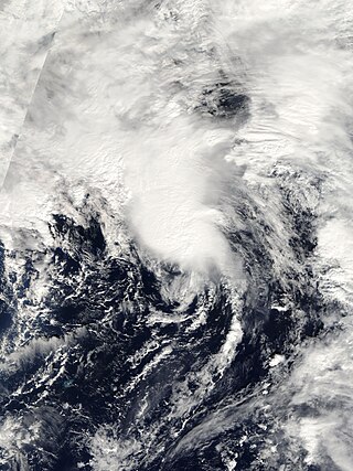
Subtropical Storm Nicole was the first subtropical storm to receive a name using the standard hurricane name list that did not become a tropical cyclone. The fifteenth tropical or subtropical cyclone and fourteenth named storm of the 2004 Atlantic hurricane season, Nicole developed on October 10 near Bermuda from a broad surface low that developed as a result of the interaction between an upper level trough and a decaying cold front. The storm turned to the northeast, passing close to Bermuda as it intensified to reach peak winds of 50 mph (80 km/h) on October 11. Deep convection developed near the center of the system as it attempted to become a fully tropical cyclone. However, it failed to do so and was absorbed by an extratropical cyclone late on October 11.

<span class="mw-page-title-main">Hurricane Gordon (2006)</span> Category 3 Atlantic hurricane

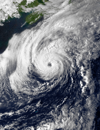
Hurricane Gordon was the first tropical cyclone since 1992 to affect the Azores while retaining tropical characteristics. The eighth tropical storm, third hurricane, and first major hurricane of the 2006 Atlantic hurricane season, Gordon formed on September 10 in the tropical Atlantic Ocean. It gradually matured into a hurricane as it tracked northward, reaching its peak intensity with winds of 195 km/h (121 mph) early on September 14 while located about 925 km (575 mi) southeast of Bermuda. After becoming nearly stationary, Gordon weakened to minimal hurricane status, although it re-intensified after accelerating to the east. It weakened again after moving over cooler waters, and passed through the Azores on September 20. Shortly thereafter, it became an extratropical cyclone and subsequently affected Spain, Ireland, and the United Kingdom.

<span class="mw-page-title-main">Hurricane Debby (1982)</span> Category 4 Atlantic hurricane in 1982

Hurricane Debby was the strongest tropical cyclone of the 1982 Atlantic hurricane season, with winds peaking at 130 mph (210 km/h). The fourth named storm, second hurricane, and the only major hurricane of the season, Debby developed near the north coast of Hispaniola from a westward moving tropical wave on September 13, 1982. Forming as a tropical depression, it headed northwestward, and eventually strengthened into Tropical Storm Debby the following day. Thereafter, Debby rapidly intensified into a hurricane early on September 15. The hurricane then curved northeastward and grazed Bermuda as a Category 2 hurricane on September 16. It continued to strengthen, and by September 18, Debby briefly peaked as a Category 4 hurricane on the Saffir–Simpson Hurricane Scale, with winds at 130 mph (210 km/h) and a minimum pressure of 950 mbar.

<span class="mw-page-title-main">Hurricane Bob</span> Category 3 Atlantic hurricane in 1991

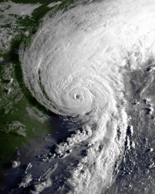
Hurricane Bob was one of the costliest hurricanes in New England history. The second named storm and first hurricane of the 1991 Atlantic hurricane season, Bob developed from an area of low pressure near The Bahamas on August 16. The depression steadily intensified, and became Tropical Storm Bob late on August 16. Bob curved north-northwestward as a tropical storm, but re-curved to the north-northeast after becoming a hurricane on August 17. As such, it brushed the Outer Banks of North Carolina on August 18 and August 19, and subsequently intensified into a major hurricane. After peaking in intensity with maximum sustained winds of 115 mph (185 km/h), Bob weakened slightly as it approached the coast of New England.

<span class="mw-page-title-main">2010 Atlantic hurricane season</span> Hurricane season in the Atlantic Ocean

The 2010 Atlantic hurricane season was the first of three consecutive very active Atlantic hurricane seasons, each with 19 named storms. This above average activity included 12 hurricanes, equaling the number that formed in 1969. Only the 2020 and 2005 seasons have had more, at 14 and 15 hurricanes respectively. Despite the high number of hurricanes, not one hurricane hit the United States making the season the only season with 10 or more hurricanes without a United States landfall. The overall tropical cyclone count in the Atlantic exceeded that in the West Pacific for only the second time on record. The season officially began on June 1 and ended on November 30, dates that conventionally delimit the period during each year when tropical cyclone formation is most likely. The first cyclone, Alex intensified into the first June hurricane since Allison in 1995. The month of September featured eight named storms. October featured five hurricanes, including Tomas, which became the latest on record in a calendar year to move through the Windward Islands. Activity was represented with an accumulated cyclone energy (ACE) value of 165 units, which was the eleventh highest value on record at the time. The activity in 2010 was heightened due to a very strong La Niña, which also led to an inactive Pacific hurricane season.

<span class="mw-page-title-main">Braer Storm</span> Intense extratropical cyclone 1993 over the northern Atlantic Ocean

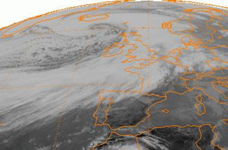
The Braer Storm was the most intense extratropical cyclone ever recorded over the northern Atlantic Ocean. Developing as a weak frontal wave on 8 January 1993, the system moved rapidly northeast. The combination of the absorption of a second low-pressure area to its southeast, a stronger than normal sea surface temperature differential along its path, and the presence of a strong jet stream aloft led to a rapid strengthening of the storm, with its central pressure falling to an estimated 914 hPa on 10 January. Its strength was well predicted by forecasters in the United Kingdom, and warnings were issued before the low initially developed.

<span class="mw-page-title-main">Mediterranean tropical-like cyclone</span> Hurricane-like storms in the Mediterranean Sea

Mediterranean tropical-like cyclones, often referred to as Mediterranean cyclones or Mediterranean hurricanes, and informally as medicanes, are meteorological phenomena occasionally observed over the Mediterranean Sea. On a few rare occasions, some storms have been observed reaching the strength of a Category 1 hurricane, on the Saffir–Simpson scale, and a storm in 2020 was recorded reaching Category 2 intensity. The main societal hazard posed by medicanes is not usually from destructive winds, but through life-threatening torrential rains and flash floods.

<span class="mw-page-title-main">Cyclone Qendresa</span>

Cyclone Qendresa, also known as Medicane Qendresa, was one of the most intense Mediterranean tropical-like cyclones on record, which struck Malta and the Italian island of Sicily in 2014. The storm formed on 5 November and rapidly intensified two days later, reaching peak intensity on 7 November, due to a cold-core low aloft. Qendresa directly hit Malta in the afternoon and then crossed the eastern coast of Sicily on 8 November. Later, the cyclone weakened significantly and dissipated over Crete on 11 November. Academic sources indicate that Qendresa transitioned into a subtropical cyclone, prior to reaching peak intensity. Qendresa caused three fatalities, and at least $250 million in damages in Italy.

The 2017–2018 European windstorm season was the third instance of seasonal European windstorm naming. France, Spain and Portugal took part in winter storm naming for the first time this season.

The 2018–2019 European windstorm season was the fourth instance of seasonal European windstorm naming in Europe. Most storms form between September and March. The first named storm, Ali, affected primarily the United Kingdom and Ireland on 19 September 2018.

<span class="mw-page-title-main">2019–20 European windstorm season</span> Windstorm season in Europe

The 2019–20 European windstorm season was the fifth instance of seasonal European windstorm naming in Europe. This is the first season in which the Netherlands participates, joining Ireland's and the United Kingdom's meteorological agencies. The new season's storm names were released on 6 September 2019. In July 2019, it was announced that storm seasons would run from 1 September 2019 to 1 September 2020. The Portuguese, Spanish and French meteorological agencies again collaborated too, joined by the Belgian meteorological agency.

<span class="mw-page-title-main">2022–23 European windstorm season</span> Windstorm season in Europe

The 2022–23 European windstorm season is the deadliest and costliest European windstorm season on record, mainly because of Storm Daniel, which became the deadliest and costliest medicane ever recorded as well as the deadliest tropical or subtropical system worldwide since 2008.

References

  1. "BRITAIN IS BATTERED BY 95 MPH WINDS". Swazi Observer. 19 January 2018. Retrieved 19 January 2018.
  2. Office, Met. "Capel Curig climate". www.metoffice.gov.uk. Retrieved 28 January 2018.
  3. 1 2 3 Wetterdienst, Deutscher. "Orkantief FRIEDERIKE wütet am 18. Januar 2018 über Europa" (PDF) (in German). Retrieved 29 January 2018.
  4. "Wetterdienst: "Das ist ein Extremorkan"". Miteteldeutscher Rundfunk. 18 January 2018. Archived from the original on 19 January 2018. Retrieved 18 January 2018.
  5. 1 2 ""Friederike" kostet rund eine Milliarde Euro". Tagesschau (ARD). 25 January 2018. Retrieved 25 January 2018.
  6. 1 2 3 4 "CURRENT CATASTROPHES". Archived from the original on 5 February 2018. Retrieved 21 August 2023.
  7. Lerner, Matthew (26 January 2018). "Storm Friederike insured losses mount". Business Insurance.
  8. "Thousands lose power after gales hit UK". BBC News. 18 January 2018. Retrieved 18 January 2018.
  9. 1 2 "Liveblog: Orkan "Friederike" fordert zwei Todesopfer - Fernverkehr bundesweit eingestellt". wz.de. 18 January 2018. Retrieved 18 January 2018.
  10. "NOAA Doppler Image of Isobars (14-January-2018)". www.wpc.ncep.noaa.gov. Retrieved 18 January 2018.[ title missing ]
  11. "1800 UTC 14 Jan 2018 Analysis chart". Met Office. Retrieved 20 January 2018.
  12. "NOAA Doppler Image of Isobars (16-January-2018)". www.wpc.ncep.noaa.gov. Retrieved 18 January 2018.[ title missing ]
  13. "David/Friederike while opening up into a trough". Archived from the original (GIF) on 19 November 2020. Retrieved 21 August 2023.
  14. "Analyse" (GIF). Free University of Berlin (in German). 18 November 2018. Archived from the original on 19 July 2023. Retrieved 19 July 2023.
  15. "Analyse_20180119.gif". met.fu-berlin.de.[ permanent dead link ]
  16. "Analyse_20180120.gif". met.fu-berlin.de.[ permanent dead link ]
  17. "Analyse_20180121.gif". met.fu-berlin.de (in German). Archived from the original on 19 November 2020. Retrieved 17 May 2023.
  18. "Analyse_20180122.gif". met.fu-berlin.de.[ permanent dead link ]
  19. "Orkan: Tote und Bahn-Chaos". ZDF. 18 January 2018. Retrieved 19 January 2018.
  20. "Storm Friederike kills at least seven across western Europe with winds of 200 kph". Euronews. 18 January 2018. Retrieved 19 January 2018.
  21. "The Latest: 6 dead as high winds sweep across western Europe". Bradenton. 18 January 2018. Retrieved 18 January 2018.
  22. RMS. "Friederike/David: The Day Our Luck Ran Out?" . Retrieved 27 February 2018.
  23. "Orkantief "Friederike" - "Die Bäume fallen um wie Streichhölzer"". SPIEGEL ONLINE. 18 January 2018. Retrieved 18 January 2018.
  24. 1 2 "Die Bahn fährt wieder - teilweise". ZDF. 19 January 2018. Retrieved 19 January 2018.
  25. "Bilanz nach Sturmtief "Friederike" - Sturm und bang". SPIEGEL ONLINE. 18 January 2018. Retrieved 19 January 2018.
  26. "Mehrere Tote durch Sturmtief "Friederike" in Europa". Salzburger Nachrichten. 18 January 2018. Retrieved 19 January 2018.
  27. 1 2 "Friederike: Sturmschäden in Tschechien vergleichsweise gering". Czech Radio. 19 January 2018. Retrieved 23 January 2018.
  28. 1 2 "Sturm "Friederike" kostet Versicherer etwa 500 Millionen Euro". SPIEGEL ONLINE. 18 January 2018. Retrieved 19 January 2018.
  29. "Met Office criticised for not naming storm which battered Britain as fresh weather warnings are issued". The Telegraph. 18 January 2018. Retrieved 19 January 2018.
  30. "Sturm "Friederike" verursacht Verkehrschaos in den Niederlanden". Wochenblatt. 18 January 2018. Archived from the original on 26 January 2018. Retrieved 19 January 2018.
  31. "La tempête David balaie le nord de l'Europe". le monde. 18 January 2018. Retrieved 19 January 2018.
  32. 1 2 "Aktuelle Messwerte Deutschland". kachelmannwetter.com. Retrieved 5 February 2018.
  33. "Long term weather forecast for Shannon Airport". www.yr.no. Retrieved 3 February 2018.
  34. "Tibenham, England (United Kingdom)". Archived from the original on 4 February 2018. Retrieved 21 July 2023.{{cite web}}: CS1 maint: unfit URL (link)
  35. "UK climate averages". www.metoffice.gov.uk. Retrieved 3 February 2018.
  36. "Weather Cap Gris-Nez". www.meteoblue.com. Retrieved 3 February 2018.
  37. 1 2 "Tempête DAVID ce Jeudi 18 Janvier" (in French). Archived from the original on 6 February 2018. Retrieved 21 August 2023.
  38. "Antwerpen/Deurne (Belgium) weather". www.metoffice.gov.uk. Retrieved 3 February 2018.
  39. "Vlieland (Netherlands) weather". www.metoffice.gov.uk. Retrieved 3 February 2018.
  40. 1 2 ""Friederike" ist durch". NTV. 19 January 2018. Retrieved 3 February 2018.
  41. "Wetterstation Kabelsketal - Messwerte". wetterstationen.meteomedia.de. Retrieved 3 February 2018.
  42. "Wetterstation Beverungen-Drenke - Messwerte". wetterstationen.meteomedia.de. Retrieved 3 February 2018.
  43. "Wetterstation Brocken - Messwerte". wetterstationen.meteomedia.de. Retrieved 3 February 2018.
  44. Jan Wandel; Christina Wisotzky; Florian Pantillon; Bernhard Mühr; Florian Becker; Daniel Friederich; Jonas Straub; Susanna Mohr (31 January 2018). "Wintersturm Friederike" (PDF). www.cedim.de (in German). Archived (PDF) from the original on 18 February 2022. Retrieved 20 July 2023.
  45. "Mount Pilatus Weather Forecast (2132m)". www.mountain-forecast.com. Retrieved 5 February 2018.
  46. "Snezka or Sněžka Weather Forecast (1602m)". www.mountain-forecast.com. Retrieved 3 February 2018.
  47. "Bielsko-Biała Weather Forecast". www.weather-forecast.com. Retrieved 3 February 2018.
  48. "Kasprowy Wierch Weather Forecast (1987m)". www.mountain-forecast.com. Retrieved 3 February 2018.
  49. "Sechs Todesopfer, 140.000 Haushalte ohne Strom". welt.de. 18 January 2018. Retrieved 19 January 2018.
  50. "Erste Fotos: Schneesturm erreicht jetzt Österreich". Heute Österreich. 18 January 2018. Retrieved 19 January 2018.
  51. "Sturm "Friederike" zieht Richtung Osten – Deutsche Bahn stellt in ganz Deutschland Fernverkehr ein, zehn Personen kommen ums Leben". Neue Zürcher Zeitung. 18 January 2018. Retrieved 19 January 2018.
  52. "Met Office criticised for not naming storm which battered Britain as fresh weather warnings are issued". The Telegraph. 18 January 2018. Retrieved 19 January 2018.
  53. "Sechs Todesopfer, 140.000 Haushalte ohne Strom". welt.de. 19 January 2018. Retrieved 19 January 2018.
  54. "Thema des Tages - Rückblick Sturmsaison 2017/2018". www.dwd.de (in German). Deutscher Wetterdienst. 22 September 2018. Retrieved 22 September 2018.
  55. Dutton, Liam (18 January 2018). "Why I criticised Met Eireann for naming Storm Fionn". Channel 4 News. Retrieved 24 January 2018.
  56. "18011718_UKMet_Analyse.gif" [Weather3 - current weather maps]. Wetter3 - aktuelle Wetterkarten (in German). 17 January 2018. Retrieved 17 May 2023.
  57. "18011800_UKMet_Analyse.gif" [Weather3 - current weather maps]. Wetter3- aktuelle Wetterkarten (in German). 18 January 2018. Retrieved 17 May 2023.
  58. "18011706_UKMet_Analyse.gif" [Weather3 - current weather maps]. Wetter3 - aktuelle Wetterkarten (in German). 17 January 2018.
  59. "18011712_UKMet_Analyse.gif" [Weather3- current weather maps]. Wetter3 - aktuelle Wetterkarten (in German). 17 January 2018. Retrieved 17 May 2023.