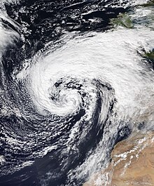
Hurricane Donna,known in Puerto Rico as Hurricane San Lorenzo,was the strongest hurricane of the 1960 Atlantic hurricane season,and caused severe damage to the Lesser Antilles,the Greater Antilles,and the East Coast of the United States,especially Florida,in August–September. The fifth tropical cyclone,third hurricane,and first major hurricane of the season,Donna developed south of Cape Verde on August 29,spawned by a tropical wave to which 63 deaths from a plane crash in Senegal were attributed. The depression strengthened into Tropical Storm Donna by the following day. Donna moved west-northwestward at roughly 20 mph (32 km/h) and by September 1,it reached hurricane status. Over the next three days,Donna deepened significantly and reached maximum sustained winds of 130 mph (210 km/h) on September 4. Thereafter,it maintained intensity as it struck the Lesser Antilles later that day. On Sint Maarten,the storm left a quarter of the island's population homeless and killed seven people. An additional five deaths were reported in Anguilla,and there were seven other fatalities throughout the Virgin Islands. In Puerto Rico,severe flash flooding led to 107 fatalities,85 of them in Humacao alone.

The Burns' Day Storm was an extremely violent windstorm that took place on 25–26 January 1990 over North-Western Europe. It is one of the strongest European windstorms on record and caused many fatalities in the UK and Europe. This storm has received different names,as there was no official list of such events in Europe at the time. Starting on Burns Day,the birthday of the Scottish poet Robert Burns,it caused widespread damage and hurricane-force winds over a wide area.
Global weather activity of 2007 profiles the major worldwide weather events,including blizzards,ice storms,tornadoes,tropical cyclones,and other weather events,from January 1,2007,to December 31,2007. Winter storms are events in which the dominant varieties of precipitation are formed during cold temperatures;they include snow or sleet,or a rainstorm where ground temperatures are cold enough to allow ice,including freezing rain,to form. Thehy may be marked by strong wind,thunder,lightning thunderstorms,heavy precipitation,including ice storm,wind transporting some substance through the atmosphere,including dust storms,snowstorms,and hail storms. Other major non winter events such as large dust storms,hurricanes,cyclones,tornados,gales,flooding,and rainstorms are also caused by such phenomena.

Typhoon Fanapi,known in the Philippines as Typhoon Inday,was a damaging and deadly typhoon that struck Taiwan and southeastern China in September 2010. It was the eleventh tropical storm and fourth typhoon of the very inactive season. The storm formed on September 14 east of the Philippines and moved slowly for several days,initially to the northwest,then curving to the northeast before turning westward due to a ridge to the north. During this time,Fanapi intensified to reach 10 minute maximum sustained winds of 175 km/h (109 mph). Fanapi made its first landfall on September 19 over Hualien,Taiwan,becoming the first typhoon to hit the island since Typhoon Morakot in August 2009. Later that day made a final landfall in Fujian,China. The storm dissipated on September 21 over southern China.
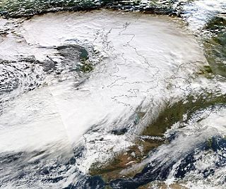
The winter of 2010–2011 in Europe began with an unusually cold November caused by a cold weather cycle that started in southern Scandinavia and subsequently moved south and west over both Belgium and the Netherlands on 25 November and into the west of Scotland and north east England on 26 November. This was due to a low pressure zone in the Baltics,with a high pressure over Greenland on 24 November,and ended on 3 May 2011 in Poland.

Cyclone Andrea was an intense European windstorm that affected western and central Europe in early January 2012.

Cyclone Xaver,also known as the North Sea flood or tidal surge of 2013,was a winter storm that affected northern Europe. Force 12 winds and heavy snowfall were predicted along the storm's path,and there were warnings of a significant risk of storm surge leading to coastal flooding along the coasts of the North and Irish Seas.
Cyclone Dirk was a large and deep European windstorm that affected Western Europe from the Iberian Peninsula to Iceland from 22 December 2013.
The 2015–16 UK and Ireland windstorm season was the first instance of the United Kingdom's Met Office and Ireland's Met Éireann naming extratropical cyclones. The season started on 10 November with the naming of Storm Abigail and ended on 28 March with the dissipation of Storm Katie. With a total of eleven named storms,the 2015–16 season is the most active to date.

Storm Desmond was an extratropical cyclone and fourth named storm of the 2015–16 UK and Ireland windstorm season,notable for directing a plume of moist air,known as an atmospheric river,which brought record amounts of orographic rainfall to upland areas of northern Atlantic Europe and subsequent major floods.
The 2016–17 UK and Ireland windstorm season was the second instance of the United Kingdom's Met Office and Ireland's Met Éireann naming extratropical cyclones. Substantially less active than the previous season,the season succeeded the 2015–16 UK and Ireland windstorm season and preceded the 2017–18 European windstorm season.

Severe weather events or extreme weather events in Sydney,Australia,include hailstorms,thunderstorms,gale,bushfires,heatwaves,drought,and flash flooding from heavy rain. Sydney is rarely affected by cyclones,although remnants of cyclones do affect the city.

Super Cyclonic Storm Amphan was an extremely powerful and catastrophic tropical cyclone that caused widespread damage in Eastern India,specifically in West Bengal and Odisha,and in Bangladesh,in May 2020. It was the strongest tropical cyclone to strike the Ganges Delta. It was a rare cyclone that lashed northern Bangladesh from Rajshahi to Rangpur in the early hours of 21 May with strong winds. It was also the fourth super cyclone that hit West Bengal and Kolkata since 2015 as well as being one of the strongest storms to impact the area. Causing over US$13 billion of damage,Amphan is also the costliest cyclone ever recorded in the North Indian Ocean,surpassing the record held by Cyclone Nargis of 2008.

Typhoon Cimaron was a typhoon that caused minimal impacts in the Mariana Islands and Japan in August 2018. The twenty-third depression,twenty-first named storm,eleventh severe tropical storm,and seventh typhoon of the 2018 Pacific typhoon season,Cimaron developed from a tropical depression near the Marshall Islands on August 16. The depression soon became Tropical Storm Cimaron on August 18. Cimaron gradually intensified into a typhoon on August 21,and rapidly reached its peak intensity the next day. Cimaron then weakened before making two landfalls in Japan as a Category 1 typhoon on August 23. Cimaron continued to weaken until it became an extratropical cyclone and dissipated on August 24.
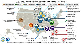
The following is a list of weather events that occurred on Earth in the year 2022. The year began with a La Niña. There were several natural disasters around the world from various types of weather,including blizzards,cold waves,droughts,heat waves,wildfires,floods,tornadoes,and tropical cyclones. The deadliest weather event of the year were the European heat waves,which killed over 26,000 people,11,000 of which were in France. The costliest weather event of the year was Hurricane Ian,which caused at least $112.9 billion in damages in Florida and Cuba. Another significant weather event was the Pakistan floods,which killed 1,739 people and a total of $14.9 billion in damages.

Storm Eunice was an extremely powerful extratropical cyclone with hurricane-force winds that was part of the 2021–2022 European windstorm season. Storm Eunice was named by the UK Met Office on 14 February 2022. A red weather warning was issued on 17 February for parts of South West England and South Wales,with a second red warning issued on 18 February,the day the storm struck,for London,the South East and East of England.

The 2022–23 European windstorm season was the deadliest and costliest European windstorm season on record,mainly because of the impact in Northern Libya of Storm Daniel,which became the deadliest and costliest medicane ever recorded as well as the deadliest tropical or subtropical system worldwide since 2008.
In 2023,the United Kingdom experienced flooding.

The 2023–2024 European windstorm season is the ninth and current season of the European windstorm naming in Europe. The new season's storm names were announced on 1 September 2023. Storms that occur up until 31 August 2024 will be included in this season. This was the fifth season where the Netherlands participated,alongside the United Kingdom's Met Office and Ireland's Met Éireann in the western group. The Portuguese,Spanish,French and Belgian meteorological agencies collaborated for the seventh time,joined by Luxembourg's agency. This is the third season where Greece,Israel and Cyprus,and Italy,Slovenia,Croatia,Montenegro,North Macedonia and Malta named storms which affected their areas.

Storm Ciarán,known in Germany as Storm Emir was a European windstorm that severely affected parts of Europe from late October to early November 2023. Part of the 2023–24 European windstorm season,Ciarán impacted northwestern Europe and killed 21 people,eleven of whom were in Italy and four in France. It also caused mass disruption to transport. Widespread damage from 100 miles per hour (160 km/h) winds were reported in the Channel Islands,while 1.2 million French households were left without electricity.