Archer Lodge, North Carolina

Last updated

Archer Lodge, North Carolina
Archer Lodge town sign.jpg
Motto: 
"The Best Corner of the World"
USA North Carolina location map.svg
Red pog.svg
Archer Lodge
Usa edcp location map.svg
Red pog.svg
Archer Lodge
Coordinates: 35°41′26″N78°22′30″W / 35.69056°N 78.37500°W / 35.69056; -78.37500
Country United States
State North Carolina
County Johnston
Incorporated2009
Area
[1]
  Total9.08 sq mi (23.53 km2)
  Land9.07 sq mi (23.48 km2)
  Water0.02 sq mi (0.04 km2)
Elevation
[2]
315 ft (96 m)
Population
 (2020)
  Total4,797
  Density529.06/sq mi (204.27/km2)
Time zone UTC-5 (Eastern (EST))
  Summer (DST) UTC-4 (EDT)
ZIP codes
27591, 27527
Area code 919
FIPS code 37-01760
GNIS feature ID2612171 [2]
Website www.townofarcherlodge.com

Archer Lodge is a town in Johnston County, North Carolina, United States. Its population was 4,292 as of the 2010 census, [3] and as of 2018 the estimated population was 5,014. [4]

Contents

History

A Masonic lodge named Archer No. 157 was established by the Grand Lodge of Ancient, Free, and Accepted Masons of North Carolina on December 6, 1854, at what was then known as Creachville. In 1865, the lodge building was razed and the charter destroyed by Gen. William T. Sherman's Union Army on their way to Raleigh. The lodge received a new charter after the war, but a clerical error resulted in a misnumeration, and it was designated Archer Lodge No. 165. [5]

The community has had several post offices over the years. The first was called "Creachville", which existed from 1851 to 1866. This was followed by Archer Lodge (1877–1896). It was known as "Archer" from 1896 to 1912, when it closed. After 1912, the area was covered by either the Clayton or Wendell post offices. [6]

The people of Archer Lodge voted on November 3, 2009, to incorporate Archer Lodge as a town. The vote was certified one week later.[ citation needed ]

The Archer Lodge community is one of the fastest growing areas of Johnston County. A new middle school, Archer Lodge Middle School, opened in 2007, and the new high school, Corinth Holders High School, opened its doors in 2010 northeast of the town limits. [7] [8]

Geography

Archer Lodge is in northern Johnston County, centered on the intersection of Buffalo Road and Covered Bridge Road, about 7 miles (11 km) south of Wendell and the same distance northeast of Clayton. According to the U.S. Census Bureau, the town has a total area of 9.3 square miles (24.1 km2), of which 0.03 square miles (0.07 km2), or 0.29%, are water. [3] The town is within the Neuse River watershed.

Demographics

Historical population
CensusPop.Note
1970 711
1980 87222.6%
1990 795−8.8%
2000 7950.0%
2010 4,292439.9%
2020 4,79711.8%
U.S. Decennial Census [9]

2020 census

Archer Lodge racial composition [10]
RaceNumberPercentage
White (non-Hispanic)3,36370.11%
Black or African American (non-Hispanic)3577.44%
Native American 220.46%
Asian 270.56%
Pacific Islander 40.08%
Other/Mixed 2665.55%
Hispanic or Latino 75815.8%

As of the 2020 United States census, there were 4,797 people, 1,648 households, and 1,393 families residing in the town.

White Oak Baptist Church White Oak Baptist Church.jpg
White Oak Baptist Church

Arts and culture

The most significant landmark in the community is C.E. Barnes Store, which has been in operation for 96 years. The C.E. Barnes Store was renamed the Archer Lodge Express in 2023. The old Masonic Lodge used to be located right next door. The building that used to be the boarding house for the teachers at Archer Lodge School still stands next to the ball park and is being used as a private residence. White Oak Baptist Church stands at the heart of the community. The church used to be known as the Archer Lodge Missionary Baptist Church, but changed its name when it moved to its current location under a stand of white oak trees.

Related Research Articles

<span class="mw-page-title-main">Nash County, North Carolina</span> County in North Carolina, United States

Nash County is a county located in the U.S. state of North Carolina. As of the 2020 census, the population was 94,970. Its county seat is Nashville.

<span class="mw-page-title-main">Johnston County, North Carolina</span> County in North Carolina, United States

Johnston County is a county located in the U.S. state of North Carolina. As of the 2020 census, the population was 215,999. Its county seat is Smithfield.

<span class="mw-page-title-main">Camden County, North Carolina</span> Consolidated city-county in North Carolina, United States

Camden County is a consolidated city-county located in the U.S. state of North Carolina. As of the 2020 census, the population was 10,355, making it the fourth-least populous county in North Carolina. Its county seat is Camden. Camden County is included in the Virginia Beach-Chesapeake, VA-NC Combined Statistical Area.

<span class="mw-page-title-main">Concord, North Carolina</span> City in North Carolina, United States

Concord is the county seat and most populous city in Cabarrus County, in the U.S. state of North Carolina. At the 2020 census, the city had a population of 105,240. In terms of population, the city of Concord is the second-most populous city in the Charlotte metropolitan area and is the 10th-most populous city in North Carolina and 287th-most populous city in the U.S.

<span class="mw-page-title-main">Yanceyville, North Carolina</span> Town in North Carolina, United States

Yanceyville is a town in and the county seat of Caswell County, North Carolina, United States. Located in the Piedmont Triad region of the state, the town had a population of 1,937 at the 2020 census.

<span class="mw-page-title-main">Fayetteville, North Carolina</span> County seat of Cumberland County, North Carolina, United States

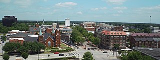
Fayetteville is a city in and the county seat of Cumberland County, North Carolina, United States. It is best known as the home of Fort Liberty, a major U.S. Army installation northwest of the city.

<span class="mw-page-title-main">Oxford, North Carolina</span> Town in North Carolina, United States

Oxford is a town in Granville County, North Carolina, United States, with a population of 8,628 as of the 2020 census. It is the county seat of Granville County.

<span class="mw-page-title-main">Benson, North Carolina</span> Town in North Carolina, United States

Benson is a town in Johnston County, North Carolina, United States, near the intersection of Interstates 95 and 40. Benson celebrates Mule Days on the fourth Saturday of September, a festival that attracts over 60,000 people each year. In 2010, the population was 3,311, up from 2,923 in 2000.

<span class="mw-page-title-main">Clayton, North Carolina</span> Town in North Carolina, United States

Clayton is a town in Johnston County, North Carolina, United States, and is considered a satellite town of Raleigh. As of 2010, Clayton's population was 16,116, up from 6,973 at the 2000 census. By 2019 the town's estimated population was 24,887. Much of that growth can be attributed to the town's proximity to the Research Triangle area and access to major highways such as I-40 and US 70.

<span class="mw-page-title-main">Selma, North Carolina</span> Town in North Carolina, United States

Selma is a town in Johnston County, North Carolina, United States. In 2010, the population was 6,073, and as of 2018 the estimated population was 6,913. Selma is part of the Raleigh-Durham-Cary Combined Statistical Area. The area has a population over 1.7 million residents, though the town of Selma is able to maintain its rural character. The Everitt P. Stevens House, located in Selma, was the site of the last Grand Review of the Confederate Army held on April 6, 1865, after its defeat at the Battle of Bentonville.

<span class="mw-page-title-main">Smithfield, North Carolina</span> Town in North Carolina, United States

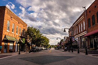
Smithfield is a town in and the county seat of Johnston County, North Carolina, United States. As of the 2010 census, its population was 10,966, and in 2019 the estimated population was 12,985. Smithfield is home to the Ava Gardner Museum and is situated along the Neuse River, where visitors enjoy the annual Smithfield Ham and Yam Festival, walks along the Buffalo Creek Greenway, and the historic downtown district. The town is located near North Carolina's Research Triangle and is about 30 miles (48 km) southeast of downtown Raleigh. The Raleigh-Durham-Cary combined statistical area has a population over 2 million residents.

<span class="mw-page-title-main">Eden, North Carolina</span> City in North Carolina, United States

Eden is a city in Rockingham County in the U.S. state of North Carolina and is part of the Greensboro-High Point Metropolitan Statistical Area of the Piedmont Triad region. As of the 2020 census, the population was 15,405. From the late nineteenth century through much of the 20th, the city was a center of textile mills and manufacturing. The city was incorporated in 1967 through the consolidation of three towns: Leaksville, Spray, and Draper.

<span class="mw-page-title-main">Holly Springs, North Carolina</span> Town in North Carolina, United States

Holly Springs is a town in Wake County, North Carolina, United States. As of the 2020 census, the town population was 41,239, a 67% increase from 2010.

<span class="mw-page-title-main">Knightdale, North Carolina</span> Town in North Carolina, United States

Knightdale is a town in Wake County, North Carolina, United States. As of the 2020 census, Knightdale has a population of 19,435, up from 11,401 in 2010. The U.S. Census Bureau estimates the town's population to be 17,843, as of July 1, 2019. Knightdale's population grew 10.4% from 2010 to 2013, making it the second fastest-growing community in the Research Triangle region for that time period.

<span class="mw-page-title-main">Wake Forest, North Carolina</span> Town in North Carolina, United States

Wake Forest is a town in Franklin and Wake counties in the U.S. state of North Carolina; located almost entirely in Wake County, it lies just north of the state capital, Raleigh. At the 2020 census, the population was 47,601, up from 30,117 in 2010. It is part of the Raleigh metropolitan area. Wake Forest was the original home of Wake Forest University for 122 years before it moved to Winston-Salem in 1956.

<span class="mw-page-title-main">Wendell, North Carolina</span> Town in North Carolina

Wendell is a town in Wake County, North Carolina, United States. It is a satellite town of Raleigh, the state capital. The population was 5,845 at the 2010 census.

<span class="mw-page-title-main">Wilson, North Carolina</span> City in North Carolina, United States

Wilson is a city in and the county seat of Wilson County, North Carolina, United States. It is the 23rd most populous city in North Carolina. Located approximately 40 mi (64 km) east of the capital city of Raleigh, it is served by the interchange of Interstate 95 and U.S. Route 264. Wilson had an estimated population of 49,459 in 2019, according to the U.S. Census Bureau, and is also an anchor city of the Rocky Mount-Wilson-Roanoke Rapids CSA, with a total population of 297,726 as of 2018.

<span class="mw-page-title-main">Zebulon, North Carolina</span> Town in North Carolina, United States

Zebulon is the easternmost town in Wake County, North Carolina, United States. The population was 6,903 at the 2020 census. Zebulon is part of the Research Triangle metropolitan region. In May 2022, Zebulon was ranked North Carolina's second fastest growing town, only behind neighboring Wendell.

<span class="mw-page-title-main">North Carolina Highway 231</span> State highway in North Carolina, US

North Carolina Highway 231 (NC 231) is a 25.4-mile-long (40.9 km) primary state highway in the U.S. state of North Carolina. NC 231 travels through Wake County, Johnston County, and Nash County between its southern terminus at US 64 Business in Wendell and its northern terminus at US 64 Alternate/NC 98 near Spring Hope. Throughout Wake County and Johnston County, NC 231 primarily follows a southeast-northwest alignment. Entering into Nash County, NC 231 turns to follow a northerly alignment until reaching its northern terminus. NC 231 serves the towns of Wendell, Middlesex, and Spring Hope.

<span class="mw-page-title-main">Johnston County School District</span>

The Johnston County School District serves Johnston County, North Carolina. Currently, Johnston County has 48 schools, which serve over 36,879 students, and experiences a 4% increase in enrollment yearly. The district is centered in the county seat, Smithfield. Dr. Eric C. Bracy was appointed as superintendent on July 1, 2020.

References

  1. "ArcGIS REST Services Directory". United States Census Bureau. Retrieved September 20, 2022.
  2. 1 2 U.S. Geological Survey Geographic Names Information System: Archer Lodge, North Carolina
  3. 1 2 "Geographic Identifiers: 2010 Census Summary File 1 (G001): Archer Lodge town, North Carolina". American Factfinder. U.S. Census Bureau. Archived from the original on February 13, 2020. Retrieved October 10, 2018.
  4. "Population and Housing Unit Estimates" . Retrieved October 14, 2019.
  5. "Archived copy" (PDF). Archived from the original (PDF) on October 6, 2008. Retrieved January 3, 2008.{{cite web}}: CS1 maint: archived copy as title (link)
  6. Notification Service | Post Offices [ permanent dead link ]
  7. "Archer Lodge Middle - Home". www.johnston.k12.nc.us. Archived from the original on September 30, 2010. Retrieved January 13, 2022.
  8. "Corinth Holders High School - Corinth Holders High School". www.johnston.k12.nc.us. Archived from the original on September 30, 2010. Retrieved January 13, 2022.
  9. "Census of Population and Housing". Census.gov. Retrieved June 4, 2015.
  10. "Explore Census Data". data.census.gov. Retrieved December 23, 2021.