Rugeley is a market town and civil parish in the Cannock Chase District, in Staffordshire, England. It lies on the north-eastern edge of Cannock Chase next to the River Trent; it is situated 8 miles (13 km) north of Lichfield, 10 miles (16 km) south-east of Stafford, 5 miles (8.0 km) north-east of Hednesford and 11 miles (18 km) south-west of Uttoxeter. At the 2021 Census, the population was 26,156.

Handsacre is a village in the English county of Staffordshire. Population details taken at the 2011 census can be found under Armitage with Handsacre

Josiah Spode was an English potter and the founder of the English Spode pottery works which became famous for the high quality of its wares. He is often credited with the establishment of blue underglaze transfer printing in Staffordshire in 1781–84, and with the definition and introduction in c. 1789–91 of the improved formula for bone china which thereafter remained the standard for all English wares of this kind.

Lichfield District is a local government district in Staffordshire, England. The district is named after its largest settlement, the city of Lichfield, which is where the district council is based. The district also contains the towns of Burntwood and Fazeley, along with numerous villages and surrounding rural areas, including part of Cannock Chase, a designated Area of Outstanding Natural Beauty.
Great Haywood is a village in central Staffordshire, England, just off the A51 and about 4.5 miles (7.2 km) northwest of Rugeley and 7.1 miles (11.4 km) southeast of the county town of Stafford. Population details taken at the 2011 census can be found under Colwich.

Armitage with Handsacre or just Armitage is a civil parish in the Lichfield district of Staffordshire, England. It includes the villages of Armitage and Handsacre, and in 2001 had a population of 5,181, rising to 5,335 at the 2011 Census.

Tixall is a small village and civil parish in the Stafford district, in the English county of Staffordshire lying on the western side of the Trent valley between Rugeley and Stone, Staffordshire and roughly 4 miles east of Stafford. The population of the civil parish taken at the 2011 census was 239.

Hamstall Ridware is a village and civil parish in the Lichfield district of Staffordshire, England. It is in the Trent Valley, and lies close to the villages of Hill Ridware, Mavesyn Ridware and Pipe Ridware. It is eight miles north of the city of Lichfield, and four miles east of Rugeley. The hamlet of Olive Green lies to the east of the village at grid reference SK116187.
Mid Staffordshire was a parliamentary constituency in the United Kingdom from 1983 until 1997.

Streethay is a village civil parish, in the Lichfield district, in the county of Staffordshire, England, adjoining the city of Lichfield, on the east side of the West Coast Main Line railway. In 2001 the parish had a population of 1111.

Stoke Minster is the Minster church of St Peter ad Vincula and main church in Stoke-upon-Trent, Staffordshire, England. Which is now the main church of the wider city of Stoke-on-Trent.
Hill Ridware is a small village in the civil parish of Mavesyn Ridware in the Lichfield District of Staffordshire, England. It is the largest settlement in the parish with a population of 857 at the 2011 Census. Situated across the River Trent from Rugeley, it is on the B5104 north of Armitage.
Colwich is a civil parish and village in Staffordshire, England. It is situated off the A51 road, about 3 miles (5 km) north-west of Rugeley and 7 miles (11 km) south-east of Stafford. It lies principally on the north-east bank of the River Trent, near Wolseley Bridge and just north of The Chase. The parish comprises about 2,862 hectares (28.62 km2) of land in the villages and hamlets of Colwich, Great Haywood, Little Haywood, Moreton, Bishton and Wolseley Bridge.

Armitage Park is a 19th-century Grade II listed country house at Armitage near Rugeley, Staffordshire.

Mavesyn Ridware is a village and civil parish in Lichfield District, Staffordshire, England. The parish had a population of 1,048 in 2001, increasing to 1,128 at the 2011 Census. It includes the villages of Hill Ridware, Rake End, Pipe Ridware and Blithbury, all of which lie between the River Trent and a small tributary, the River Blithe. To the east is the parish of Hamstall Ridware and to the south the larger village of Armitage.

Blithbury is a small village in Lichfield District, Staffordshire, England. Part of the civil parish of Mavesyn Ridware, it lies near the River Blithe, about 3 miles (5 km) north of Handsacre, 3 miles north-east of Rugeley, and 3 miles south of Abbots Bromley.

Hawkesyard Priory was a Dominican priory off Armitage Lane Brereton, Rugeley, Staffordshire, England, built between 1896 and 1914 which included the Roman Catholic Priory Church of St Thomas.
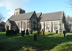
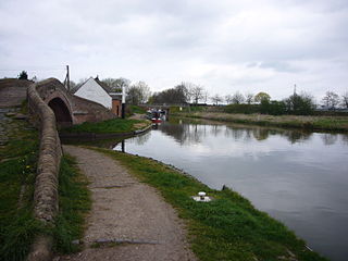
Armitage with Handsacre is a civil parish in the district of Lichfield, Staffordshire, England. It contains 19 buildings that are recorded in the National Heritage List for England. Of these, one is listed at Grade II*, the middle of the three grades, and the others are at Grade II, the lowest grade. The parish contains the villages of Armitage and Handsacre and the surrounding countryside. Most of the listed buildings are houses and farmhouses, the earlier of which are timber framed. The Trent and Mersey Canal passes through the parish, and two accommodation bridges crossing it are listed. Hawkesyard Priory is in the parish, and its priory church is listed, together with nearby Spode House and associated structures, which have connections with the priory. The other listed buildings are another church, a chapel, a churchyard cross, and a war memorial.