Ashcott

Last updated

Ashcott
Ashcott.jpg
Chapel Hill, Ashcott
Somerset UK location map.svg
Red pog.svg
Ashcott
Location within Somerset
Population1,186 (2011) [1]
OS grid reference ST4337
Unitary authority
Ceremonial county
Region
Country England
Sovereign state United Kingdom
Post town BRIDGWATER
Postcode district TA7
Dialling code 01458
Police Avon and Somerset
Fire Devon and Somerset
Ambulance South Western
UK Parliament
List of places
UK
England
Somerset
51°07′N2°49′W / 51.12°N 02.81°W / 51.12; -02.81

Ashcott is a small village and civil parish located in the Sedgemoor area of Somerset in the south-west of England. The village has a population of 1,186. [1] The parish includes the hamlets of Ashcott Corner, Berhill, Buscott, Nythe and Pedwell.

Contents

The village has five pubs and its own brewer, Moor Beer. It has a church, shop, a primary school and an all-through independent school.

The annual Ashcott BeerFest is held on the Coronation playing fields at the end of June/beginning of July each year. It raises money for the Playing Fields, Cheeky Chimps Pre-School and the Ashcott Primary School PTA.

History

The parish of Ashcott was part of the Whitley Hundred. [2]

The Bath to Exeter coach at 'The Piper's Inn', Ashcott, Somerset (1794) by John Nixon John Nixon - Nixon-98260 - The Bath to Exeter coach at 'The Piper's Inn' Ashcott, Somerset - 1794.jpg
The Bath to Exeter coach at ‘The Piper’s Inn’, Ashcott, Somerset (1794) by John Nixon

The village was a stop for mail coaches running from Bath to Exeter, and later had a station on the Evercreech Junction to Burnham-on-Sea branch of the Somerset and Dorset Joint Railway. The station was two miles away from the village, and was originally called "Ashcott and Meare", reflecting the fact that Meare was also nearby (in fact, nearer). "Meare" was dropped from the official name in 1876, though the station "running board" – the large sign on the platform – continued to give the double name until the railway line closed in 1966 under the Beeching Axe. [3]

A narrow gauge railway operated by Eclipse Peat operated from 1922 to 1983 and crossed the branch line on the level about 1/2-mile east of Ashcott station. On 29 August 1949 a train on the branch collided with a narrow gauge engine and the locomotive ended up in the adjacent Glastonbury Canal. [4]

Governance

The parish council has responsibility for local issues, including setting an annual precept (local rate) to cover the council's operating costs and producing annual accounts for public scrutiny. The parish council evaluates local planning applications and works with the local police, district council officers, and neighbourhood watch groups on matters of crime, security, and traffic. The parish council's role also includes initiating projects for the maintenance and repair of parish facilities, as well as consulting with the district council on the maintenance, repair, and improvement of highways, drainage, footpaths, public transport, and street cleaning. Conservation matters (including trees and listed buildings) and environmental issues are also the responsibility of the council.

For local government purposes, since 1 April 2023, the village comes under the unitary authority of Somerset Council. Prior to this, it was part of the non-metropolitan district of Sedgemoor, which was formed on 1 April 1974 under the Local Government Act 1972, having previously been part of Bridgwater Rural District. [5]

The village is part of 'East Polden' electoral ward. Although Ashcott is the most populous area the ward stretches to Moorlinch and Shapwick. The total population of the ward at the 2011 census was 2,130. [6]

It is also part of the Bridgwater and West Somerset county constituency represented in the House of Commons of the Parliament of the United Kingdom. It elects one Member of Parliament (MP) by the first past the post system of election.

Religious sites

All Saints Church, Ashcott, Somerset Ashcott Church.jpg
All Saints Church, Ashcott, Somerset

The Anglican parish Church of All Saints dates from the 15th century and has been designated as a Grade II* listed building. [7]

Notable residents

Ashcott was the birthplace of Joseph Trutch, a Canadian engineer, surveyor and controversial politician. It is also the home to Bradley Middleton, former professional footballer and founder of The Levels School. [8] [9]

Related Research Articles

<span class="mw-page-title-main">Sedgemoor</span> Former non-metropolitan district in England

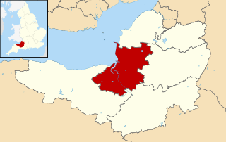
Sedgemoor is a low-lying area of land in Somerset, England. It lies close to sea level south of the Polden Hills, historically largely marsh. The eastern part is known as King's Sedgemoor, and the western part West Sedgemoor. Sedgemoor is part of the area now known as the Somerset Levels and Moors. Historically the area was known as the site of the Battle of Sedgemoor.

<span class="mw-page-title-main">Puriton</span> Village in Somerset, England

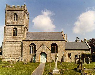
Puriton is a village and parish at the westerly end of the Polden Hills, in Somerset, England. The parish has a population of 1,968. The local parish church is dedicated to St Michael and All Angels. A chapel on Woolavington Road was converted to a private house some 20 years ago. The parish includes the hamlets of Dunball and Down End.

<span class="mw-page-title-main">Polden Hills</span>

The Polden Hills in Somerset, England are a long, low ridge, extending for 10 miles (16 km), and separated from the Mendip Hills, to which they are nearly parallel, by a marshy tract, known as the Somerset Levels. They are now bisected at their western end by the M5 motorway and a railway, the Bristol and Exeter Railway, part of the Great Western Main Line.

<span class="mw-page-title-main">Bawdrip</span> Human settlement in England

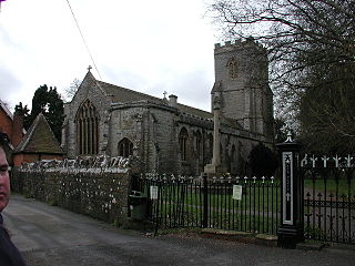
Bawdrip is a village and civil parish in Somerset, England. The village is on the south side of the Polden Hills about 4 miles (6.4 km) north-east of Bridgwater. At the 2011 census the parish had a population of 506. The parish includes the hamlets of Bradney, Horsey and Knowle.

<span class="mw-page-title-main">Edington, Somerset</span> Human settlement in England

Edington is a rural village, situated on the north side of the Polden Hills in Somerset, England.

<span class="mw-page-title-main">Chedzoy</span> Human settlement in England

Chedzoy is a civil parish village 3 miles (4.8 km) east of Bridgwater in Somerset, England.

<span class="mw-page-title-main">Westonzoyland</span> Human settlement in England

Westonzoyland is a village and civil parish in Somerset, England. It is situated on the Somerset Levels, 4 miles (6.4 km) south east of Bridgwater.

<span class="mw-page-title-main">Goathurst</span> Human settlement in England

Goathurst is a small village and civil parish in the English county of Somerset, around 3 miles from the town of Bridgwater. The parish includes the hamlets of Andersfield and Huntstile. The village is on the route of the Samaritans Way South West.

<span class="mw-page-title-main">Huntspill</span> Village in Somerset, England

Huntspill is a village and former civil parish on the Huntspill Level in Somerset, England. It lies on the A38 road, 1.5 miles (2.4 km) south of Highbridge. The village is the principal settlement in the civil parish of West Huntspill. In 2019 it had an estimated population of 1102.

<span class="mw-page-title-main">Wembdon</span> Human settlement in England

Wembdon is a semi-rural village near Bridgwater, in Somerset, England.

<span class="mw-page-title-main">East Huntspill</span> Human settlement in England

East Huntspill is a village and civil parish on the Huntspill Level, near Highbridge, Somerset, England. The civil parish includes Cote, Hackness and Bason Bridge.

<span class="mw-page-title-main">Burtle</span> Human settlement in England

Burtle is a village and civil parish on the Somerset Levels in Somerset, England.

<span class="mw-page-title-main">Greinton</span> Human settlement in England

Greinton is a village and civil parish in Somerset, England, situated on the Somerset Levels and Moors at the foot of the Polden Hills, 9 kilometres (5.6 mi) west southwest of Glastonbury and 7 miles (11 km) east of Bridgwater.

<span class="mw-page-title-main">Catcott</span> Human settlement in England

Catcott is a rural village and civil parish, situated close to Edington 7 miles (11.3 km) to the east of Bridgwater on the Somerset Levels to the north of the Polden Hills in Somerset, England.

<span class="mw-page-title-main">Chilton Polden</span> Human settlement in England

Chilton Polden is a rural village and civil parish, situated close to Edington on the Somerset Levels to the north of the Polden Hills in Somerset, England.

<span class="mw-page-title-main">Cossington, Somerset</span> Village in Somerset, England

Cossington is a village and civil parish close to Woolavington and 5 miles (8 km) north of Bridgwater, in Somerset, England. The village lies on the north side of the Polden Hills. Its population in 2021 was 640.

<span class="mw-page-title-main">Othery</span> Human settlement in England

The parish and village of Othery, established in 1515, sits on a detached extension of Sowy island on the Somerset Levels. It is 7 miles (11 km) east of Bridgwater and 4 miles (6 km) north-west of Langport. It borders the hamlets and villages of Pathe, Burrowbridge, Middlezoy, Westonzoyland and Aller, which it meets at Beer Wall. The border with Burrowbridge was defined in 1985, reducing Othery to 553 ha. Many of these borders are defined by ditches and walls created and rearranged, from the 13th century onwards, to drain and channel the waters of the River Cary and the River Parrett as they flooded the low-lying levels on their way to the Bristol Channel.

<span class="mw-page-title-main">Moorlinch</span> Human settlement in England

Moorlinch is a village and civil parish where the Polden Hills meet the Somerset Levels in Somerset, England.

Bridgwater was a rural district in Somerset, England, from 1894 to 1974.

<span class="mw-page-title-main">Shapwick School</span> Specialist school in Shapwick, Somerset, England

Shapwick School was a specialist school at Shapwick Manor in Shapwick, a village on the Somerset Levels in Somerset, England. In March 2020, it was announced that the school would close at the end of term in March due to financial difficulties.

References

  1. 1 2 "Statistics for Wards, LSOAs and Parishes — SUMMARY Profiles" (Excel). Somerset Intelligence. Retrieved 4 January 2014.
  2. "Somerset Hundreds". GENUKI. Retrieved 22 October 2011.
  3. Somerset Railway Stations, by Mike Oakley (Dovecote Press, 2002)
  4. Jacobs, Mike (2013). "The Narrow Gauge Railway at Ashcott". The Southern Way. 23: 57–63.
  5. "Bridgwater RD". A vision of Britain Through Time. University of Portsmouth. Retrieved 4 January 2014.
  6. "East Polden ward 2011" . Retrieved 6 March 2015.
  7. Historic England. "Church of All Saints (1058957)". National Heritage List for England . Retrieved 20 February 2009.
  8. "Full-back Middleton joins Weston". 21 August 2008. Retrieved 7 December 2020.
  9. "New specialist school set to open near Bridgwater next year". Bridgwater Mercury. Retrieved 7 December 2020.