North Petherton

Last updated

North Petherton
North Petherton church.jpg
Somerset UK location map.svg
Red pog.svg
North Petherton
Location within Somerset
Population6,730  [1]
OS grid reference ST290329
Unitary authority
Ceremonial county
Region
Country England
Sovereign state United Kingdom
Post town BRIDGWATER
Postcode district TA6
Dialling code 01278
Police Avon and Somerset
Fire Devon and Somerset
Ambulance South Western
UK Parliament
List of places
UK
England
Somerset
51°05′28″N3°00′47″W / 51.091°N 3.013°W / 51.091; -3.013

North Petherton is a town and civil parish in Somerset, England, situated on the edge of the eastern foothills of the Quantocks, and close to the edge of the Somerset Levels. [2] The town has a population of 6,730 as of 2014. [1] The parish includes Hamp, Melcombe, Shearston, Woolmersdon and Huntworth.

Contents

Dating from at least the 10th century and an important settlement in Saxon times, [2] North Petherton became a town only in the late 20th century, until then claiming to be the largest village in England.

A former market and administrative centre, North Petherton is now largely a dormitory town for workers in Bridgwater, 3 miles (5 km) to the north east, and Taunton, 8 miles (13 km) to the south west. The centre of the town is designated an Area of High Archaeological Potential (AHAP), and a number of buildings have been given listed building status.

Toponymy

The town is mentioned in the Domesday Book of 1086 as Nortperet. The name derives from the area's location to the north side of the River Parrett, and from the Old English nortun. [3]

History

Long before the Norman Conquest, during Saxon times North Petherton was at the centre of a large royal estate, located on one of the historic communication routes through Somerset, and was both an important centre and the meeting place for the Hundred of North Petherton [2] although the Petherton limit tithing of North Petherton was in the Hundred of Andersfield from the 1670s. [4]

At the time of the Norman invasion the Hundred covered a large area corresponding, today, roughly to a north–south corridor along the M5 motorway from Junction 25 near Taunton, to north of Junction 23 at Stretcholt, and east–west from Athelney to Goathurst. The Parish of North Petherton continues to be one of the largest in Somerset to this day. [2]

North Petherton Park

King Henry II expanded the royal estate into the Royal Forest (hunting ground) of Petherton Park, [2] which continued to exist until the 17th century. Geoffrey Chaucer (~1343–1400), author of The Canterbury Tales was appointed Deputy Forester of the Royal Forest of North Petherton towards the end of his life. [5] The Royal Forest was probably similar in area to the Saxon Hundred of North Petherton. [6] According to the late 13th century Hundred Rolls, King Henry II of England (died 1189) gave William of Wrotham lands at North Petherton. [7] Between 1513 and 1535 Sir William Courtenay (d.1535) of Powderham, Devon was the keeper of North Petherton Park. [8]

Other

The town itself it thought to have developed around the minster which, it is supposed, was on the same site as the current church. [2] There is archaeological evidence indicating that there were timber buildings to the west of the church in the late Saxon period, and it is suspected that the remains of the Saxon settlement may continue to lie beneath the town centre. [2] Excavations to the west of the church, on what is now the Community Centre site, revealed a 14th-century cemetery, which may have been used for victims of the plague, as well as indicating that the area was redeveloped in the late Middle Ages. [2] It is thought that there may have been a mint in the town during the 10th or 11th century, and a charter to hold a market was granted in 1318, although it is thought that the market predated this. [2] A shire hall, courthouse and guildhall are known to have exited and were probably located north of the church. [2]

A minor skirmish of the English Civil War took place in August 1644 outside what was then the cornhill, now the area of Fore Street between the Community Centre and the former George Inn.

The Alfred Jewel, an object about 2.5-inch (64 mm) long, made of filigree gold, cloisonné-enamelled and with a rock crystal covering, was found in 1693 at Petherton Park, North Petherton. [9] Believed to have been commissioned by Alfred the Great, [5] it is thought to have been the handle for a pointer that would have fitted into the hole at its base, and been used while reading a book out loud. It is inscribed, "AELFRED MEC HEHT GEWYRCAN," ("Alfred had me made"). It may be one of the "aestels" Alfred had sent to each bishopric with a copy of his translation of Pope Gregory the Great's book Pastoral Care . A replica of the jewel can be found in the church of St Mary.

North Newton Swing Bridge Swing bridge at North Newton.jpg
North Newton Swing Bridge

When the Bridgwater and Taunton Canal was opened in 1827 it joined the River Parrett by a lock at Huntworth, where a basin was constructed, but in 1841 the canal was extended to a floating harbour in Bridgwater, and the Huntworth link was filled in. [10] The canal and river were not re-connected at this point when the canal was restored, because the Parrett is by then a salt water river laden with silt, whereas the canal contains fresh water. Not only is there a risk of silt entering the canal, [11] but the salt water cannot be allowed to contaminate the fresh, as the canal is still used for the transport of drinking water for Bridgwater's population. [12] The Crossways Swing Bridge over the canal in the parish was built in 1827 by John Rennie. It is a wooden bridge which rotated on steel ball-bearings in a circular track, a very early example of the use of ball bearings in this way. It was designated as a Grade II listed building but the mechanism was removed in 1987. [13] [14] The Higher and Lower Maunsel locks on the canal are either side of the Maunsel bridge which carries the A361. [15] The stone Coxhill road bridge dates from the same time. [16]

Woolmersdon House in Woolmersdon is a Grade II listed late Georgian residence. [17]

In 1906, North Petherton became the first town in Britain (and perhaps the only one) [2] to have street lights lit by piped acetylene gas, supplied by the North Petherton Gas and Carbide Company, [6] operating from a plant in Mill Lane (photo). The plant was demolished towards the end of the 20th century to form a car park for the local doctor's surgery. Acetylene was replaced in 1931 by coal gas produced in Bridgwater, as well as by the provision of an electricity supply, [6] and the Gas and Carbide Company was wound up. [18] The North Petherton Rosco Acetylene Company (dating from at least 1898) may have supplied gas to the adjacent church prior to the Gas and Carbide Company.

In 1926 the Bridgwater Beam Wireless Station was opened north east of the town. It was the UK receiving station for Marconi's UK-to-Canada Beam Wireless Service, (part of the Imperial Wireless Chain,) the first transoceanic shortwave wireless telegraph service in the world and operated until 2002.

In 1984 North Petherton was provided with a small public library. As a result of a revitalised fund-raising campaign (originally begun decades earlier), this was followed a few years later by the construction of a Community Centre, opened in 1987, which was extended in 1991. [19]

Governance

The civil parish of North Petherton includes the villages of North Newton (on the route of the Bridgwater and Taunton Canal) and Northmoor Green (also known as Moorland) in the Somerset Levels, as well as a number of other smaller settlements. Despite several reductions in size, with land redesignated to neighbouring parishes, North Petherton remains one of the largest parishes in Somerset at 43 km2 (16.6 sq mi), and the largest in Sedgemoor. [2]

The town council (which is a parish council) has responsibility for local issues, including setting an annual precept (local rate) to cover the council's operating costs and producing annual accounts for public scrutiny. The town council evaluates local planning applications and works with the local police, district council officers, and neighbourhood watch groups on matters of crime, security, and traffic. The town council's role also includes initiating projects for the maintenance and repair of parish facilities, as well as consulting with the district council on the maintenance, repair, and improvement of highways, drainage, footpaths, public transport, and street cleaning. Conservation matters (including trees and listed buildings) and environmental issues are also the responsibility of the council.

For local government purposes, since 1 April 2023, the town comes under the unitary authority of Somerset Council. Prior to this, it was part of the non-metropolitan district of Sedgemoor, which was formed on 1 April 1974 under the Local Government Act 1972, having previously been part of Bridgwater Rural District. [20] Fire, police and ambulance services are provided jointly with other authorities through the Devon and Somerset Fire and Rescue Service, Avon and Somerset Constabulary and the South Western Ambulance Service.

An electoral ward exists with the same name. Although North Petherton is the most populous area the ward stretches west to Broomfield and east to Lyng. In the north the ward adjoins Bridgwater. The total population for this ward as at the 2011 census was 7,155. [21]

It is also part of the Bridgwater and West Somerset county constituency represented in the House of Commons of the Parliament of the United Kingdom. It elects one Member of Parliament (MP) by the first past the post system of election.

Geography

North Petherton is situated on one of the historic communication routes through Somerset, and a turnpike through the town was opened between Bridgwater and Taunton in the 1730s. [22] The opening of the nearby M5 motorway in the 1970s which relieved major traffic jams on the A38 through the town, also added to the attraction of the town for commuters and has consequently led to the construction of several new housing estates. The town lies on the route of the Macmillan Way West long-distance footpath.

A drain on North Moor North Moor drain.jpg
A drain on North Moor

South east of the town near Lyng, on the opposite side of the M5 motorway but within the parish is North Moor, a 676.3 hectare biological Site of Special Scientific Interest. North Moor is a nationally important grazing marsh and ditch system on the Somerset Levels and Moors. A range of neutral grassland types supporting common and scarce plants has developed mainly due to variations in soils and management practices. Aquatic plant communities are exceptionally diverse with good populations of nationally scarce species. The site has special interest in its bird life. [23]

Climate

Along with the rest of South West England, North Petherton has a temperate climate which is generally wetter and milder than the rest of the country. [24] The annual mean temperature is approximately 10  °C (50.0  °F ). Seasonal temperature variation is less extreme than most of the United Kingdom because of the adjacent sea temperatures. The summer months of July and August are the warmest with mean daily maxima of approximately 21 °C (69.8 °F). In winter mean minimum temperatures of 1 °C (33.8 °F) or 2 °C (35.6 °F) are common. [24] In the summer the Azores high pressure affects the south-west of England, however convective cloud sometimes forms inland, reducing the number of hours of sunshine. Annual sunshine rates are slightly less than the regional average of 1,600 hours. [24] In December 1998 there were 20 days without sun recorded at Yeovilton. Most of the rainfall in the south-west is caused by Atlantic depressions or by convection. Most of the rainfall in autumn and winter is caused by the Atlantic depressions, which is when they are most active. In summer, a large proportion of the rainfall is caused by sun heating the ground leading to convection and to showers and thunderstorms. Average rainfall is around 700 mm (28 in). About 8–15 days of snowfall is typical. November to March have the highest mean wind speeds, and June to August have the lightest winds. The predominant wind direction is from the south-west. [24]

Economy

Follyfoot fishery by the A38 south of North Petherton Follyfoot Fishery - geograph.org.uk - 366460.jpg
Follyfoot fishery by the A38 south of North Petherton

North Petherton used to be a market town, with the right to hold a market having been granted in 1318, along with the right to an annual fair. [2]

In the past the town hosted a Starkey Knight and Ford brewery on Fore Street (demolished in the late 1960s), several maltings, a light engineering works (Trig Engineering, since moved to the Huntworth Business Park adjacent to the nearby Junction 24 of the M5 motorway), and in earlier times at least 7 watermills.

Basket making and the manufacture of associated products including wicker furniture, was also a significant industry, at one time employing over 100 people in small factories and homes, until its decline in the second half of the 20th century. The products were distributed nationally via the railway station at Bridgwater. Nearby King's Cliff formerly provided a source of building stone for the town dating from at least Medieval times. The production of cloth and leather goods also used to take place in the town, the former being commemorated in the name of the road known as Dyer's Green.

The extensive cider orchards that used to surround much of the town in the 19th century had largely disappeared by the end of the 20th, by which time local employment was largely restricted to service businesses and farming. Folly Foot fishery is based on a lake which is stocked with Koi, Mirror, Common and Ghost Carp. [25]

A new £100 m Regional Agricultural Business Centre, including an extensive Cattle Market and Dairy opened just beyond the outskirts of the town in 2007, following construction which began in 2006. [26] [27] This replaced the cattle markets in both Taunton and Bridgwater.

Education

North Petherton junior school North Petherton junior school.jpg
North Petherton junior school

North Petherton has two schools, North Petherton juniors and North Petherton infants, however they have been joined together to form one school, North Petherton Primary School.

Secondary schools in nearby Bridgwater include: Robert Blake Science College, Brymore School, Chilton Trinity School, East Bridgwater Community School which was previously known as Sydenham School and is a Performing and Visual Arts College, [28] and Haygrove School which has specialist Language College status. [29] Special schools in the town include: Elmwood Special School, New Horizon Centre School and Penrose School.

Further Education is provided by Bridgwater College which was formerly Bridgwater Technical School. [30]

Religious sites

The community centre with St Mary's church tower behind North Petherton community centre.jpg
The community centre with St Mary's church tower behind

The town has the minster church of St Mary the Virgin, with a highly decorated tower which, at 112 feet (34 metres) high, [31] is claimed to be one of the tallest towers in the West Country. The building is mainly dated from the 15th century, with a minstrel gallery from 1623, a peal of six bells, and a clock built in Bridgwater in 1807. It has been designated by English Heritage as a grade I listed building. [32] A specification of the organ can be found on the National Pipe Organ Register.

The Church of St Peter has a tower which may be of Saxon origin which was altered in 1635. The rest of the church was completely rebuilt for Rev. Thomas Eaton in 1885. It is Grade II* listed. [33]

The Church of St. Michael has Norman origins and has seen various restorations since. It was last restored and extended in 1868 for Slade family of Maunsel House. [34]

In the cemetery is a 19th-century combined Non-conformist and Anglican Mortuary Chapel. [35]

Culture

The annual North Petherton Carnival is part of the West Country Carnival circuit, and takes place in November, on the second Saturday in November. The date of the first Carnival at Bridgwater is the previous Saturday, featuring most of the same participants.

The Walnut Tree (rebranded in the 1970s from the Clarence Hotel, and before that as the New Inn) is one of three hotels in the town, it was formerly in competition with the George Hotel (now closed), where monthly petty sessions (court hearings) were formerly held. The hotel is also used as the Headquarters for Pentathlon Carnival Club, one of the carnival clubs which class North Petherton as its local carnival.

Twinning

See also

Related Research Articles

<span class="mw-page-title-main">Somerset</span> County in South West England

Somerset is a ceremonial county in South West England. It is bordered by the Bristol Channel, Gloucestershire, and Bristol to the north, Wiltshire to the east and the north-east, Dorset to the south-east, and Devon to the south-west. The largest settlement is the city of Bath, and the county town is Taunton.

<span class="mw-page-title-main">Bridgwater</span> Human settlement in England

Bridgwater is a historic market town and civil parish in Somerset, England. The town had a population of 41,276 at the 2021 Census. Bridgwater is at the edge of the Somerset Levels, in level and well-wooded country. The town lies along both sides of the River Parrett; it has been a major inland port and trading centre since the industrial revolution. Most of its industrial bases still stand today. Its larger neighbour, Taunton, is linked to Bridgwater via a canal, the M5 motorway and the GWR railway line.

<span class="mw-page-title-main">River Parrett</span> River in Dorset and Somerset, England

The River Parrett flows through the counties of Dorset and Somerset in South West England, from its source in the Thorney Mills springs in the hills around Chedington in Dorset. Flowing northwest through Somerset and the Somerset Levels to its mouth at Burnham-on-Sea, into the Bridgwater Bay nature reserve on the Bristol Channel, the Parrett and its tributaries drain an area of 660 square miles (1,700 km2) – about 50 per cent of Somerset's land area, with a population of 300,000.

<span class="mw-page-title-main">Bridgwater and Taunton Canal</span> Canal in south-west England

The Bridgwater and Taunton Canal is a canal in the south-west of England between Bridgwater and Taunton, opened in 1827 and linking the River Tone to the River Parrett. There were a number of abortive schemes to link the Bristol Channel to the English Channel by waterway in the 18th and early 19th centuries. These schemes followed the approximate route eventually taken by the Bridgwater and Taunton Canal, but the canal was instead built as part of a plan to link Bristol to Taunton by waterway.

<span class="mw-page-title-main">Wellington, Somerset</span> Human settlement in England

Wellington is a market town in rural Somerset, a county in the west of England, situated 7 miles (11 km) south west of Taunton, near the border with Devon, which runs along the Blackdown Hills to the south of the town. The town has a population of 14,549, which includes the residents of the parish of Wellington Without, and the villages of Tone and Tonedale.

<span class="mw-page-title-main">Creech St Michael</span> Human settlement in England

Creech St Michael is a village and civil parish in Somerset, three miles east of Taunton. The parish straddles the M5 motorway and includes several scattered settlements. The village of Creech St Michael and the hamlets of Charlton, Creech Heathfield, and Ham lie east of the motorway. The hamlets of Adsborough, Coombe, Langaller, and Walford lie west of the motorway. The parish has a population of 2,416.

<span class="mw-page-title-main">Durston</span> Human settlement in England

Durston is a village and civil parish in Somerset, England, situated on the A361 road 5 miles (8.0 km) north east of Taunton and 6 miles (9.7 km) south of Bridgwater. The parish lies on undulating ground between the lowest slopes of the Quantock Hills and the valley of the River Tone at the Curry and Hay Moors. The parish has a population of 136.

<span class="mw-page-title-main">West Monkton</span> Human settlement in England

West Monkton is a village and civil parish in Somerset, England, situated 2 miles (3.2 km) north east of Taunton. The parish includes the hamlets of Monkton Heathfield, Bathpool, and Burlinch and the western parts of Coombe and Walford, and had a population of 2,787 at the 2011 census.

<span class="mw-page-title-main">Bawdrip</span> Human settlement in England

Bawdrip is a village and civil parish in Somerset, England. The village is on the south side of the Polden Hills about 4 miles (6.4 km) north-east of Bridgwater. At the 2011 census the parish had a population of 506. The parish includes the hamlets of Bradney, Horsey and Knowle.

<span class="mw-page-title-main">Goathurst</span> Human settlement in England

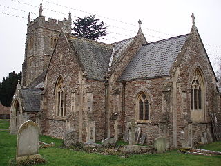
Goathurst is a small village and civil parish in the English county of Somerset, around 3 miles from the town of Bridgwater. The parish includes the hamlets of Andersfield and Huntstile. The village is on the route of the Samaritans Way South West.

<span class="mw-page-title-main">Bridgwater Canalside Centre</span>

The Bridgwater Canalside Centre was renamed 'The Canalside' in February 2008 and is a facility located near to the village of Huntworth on the outskirts of Bridgwater in Somerset, England.

<span class="mw-page-title-main">Otterhampton</span> Human settlement in England

Otterhampton is a village and civil parish in Somerset, England, between Bridgwater and the Steart Peninsula. The civil parish includes the larger village of Combwich and the small village of Steart.

<span class="mw-page-title-main">Spaxton</span> Human settlement in England

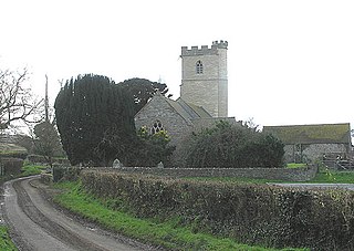
Spaxton is a small village and civil parish on the Quantocks in Somerset, South West England.

<span class="mw-page-title-main">Durleigh</span> Human settlement in England

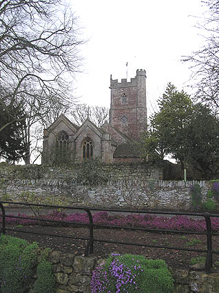
Durleigh is a village and civil parish on the outskirts of Bridgwater in Somerset, England. According to the 2011 Census, it had a population of 548. Its nearest town is Bridgwater, which lies approximately 1.6 miles (2.6 km) north-east from the village.

<span class="mw-page-title-main">South Petherton</span> Village and civil parish in Somerset, England

South Petherton is a large village and civil parish in the South Somerset district of Somerset, England, located 5 miles (8 km) east of Ilminster and 5 miles (8 km) north of Crewkerne. The parish had a population of 3,737 in 2021 and includes the smaller village of Over Stratton and the hamlets of Compton Durville, Drayton, Wigborough and Yeabridge. The River Parrett forms the eastern boundary of the parish. The village is approximately 2 miles (3 km) from East Lambrook, Martock and Lopen.

<span class="mw-page-title-main">Port of Bridgwater</span> Port in England

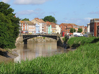
The Port of Bridgwater is a port, originally located in the town of Bridgwater, Somerset, England. Created under an 1845 Act of Parliament, it extends from Brean Down to Hinkley Point in Bridgwater Bay, and parts of the rivers Parrett, River Brue and River Axe. Although no ships now dock in the town, in 2001 103,613 (metric) tonnes of cargo were handled within the area of the Port Authority, most of which were stone products through the wharf at Dunball.

<span class="mw-page-title-main">Hundred of North Petherton</span>

The Hundred of North Petherton is one of the 40 historical Hundreds in the ceremonial county of Somerset, England, dating from before the Norman conquest. Although the Hundreds have never been formally abolished, their functions ended with the establishment of county courts in 1867 and the introduction of districts by the Local Government Act 1894. The name of the hundred derives from the name of the large royal estate that covered much of the area in 1086, recorded variously as Nortpetret in the Domesday Book, Nortpedret in Liber Exoniensis and Nort Peretu in the associated tax returns. This, in turn, was derived from the area's location to the northern end of the River Parrett.

<span class="mw-page-title-main">Walford, Somerset</span> Human settlement in England

Walford is a small village 3 miles (5 km) north east of Taunton in Somerset, England. Most of the village, including Walford Cross at the junction of the A38 and the A361, lies in the civil parish of Creech St Michael. The western part of the village, including Walford House, is in the civil parish of West Monkton. The village lies close to the A38 and the M5 motorway.

<span class="mw-page-title-main">Petherton Park</span> Historic site in Somerset, England

Petherton Park was a Deer park around North Petherton within the English county of Somerset.

<span class="mw-page-title-main">St Mary's Church, Stringston</span> Church in Somerset, England

The Anglican St Mary's Church at Stringston in the English county of Somerset dates from the 17th century. It has been designated as a Grade II listed building.

References

  1. 1 2 "Statistics for Wards, LSOAs and Parishes — SUMMARY Profiles" (Excel). Somerset Intelligence. Retrieved 4 January 2014.
  2. 1 2 3 4 5 6 7 8 9 10 11 12 13 Gathercole, Clare. "North Petherton" (PDF). The Somerset Urban Archaeological Survey. Somerset County Council. Archived from the original (PDF) on 19 October 2014. Retrieved 27 October 2012.
  3. Robinson, Stephen (1992). Somerset Place Names. Dovecote Press. ISBN   1-874336-03-2.
  4. A P Baggs; M C Siraut (1992). R W Dunning; C R Elrington (eds.). "North Petherton: Local government". A History of the County of Somerset: Volume 6: Andersfield, Cannington, and North Petherton Hundreds (Bridgwater and neighbouring parishes). Institute of Historical Research. Retrieved 13 October 2011.
  5. 1 2 "Local History". North Petherton. Retrieved 19 November 2007.
  6. 1 2 3 A P Baggs; M C Siraut (1992). R W Dunning; C R Elrington (eds.). "North Petherton". A History of the County of Somerset: Volume 6: Andersfield, Cannington, and North Petherton Hundreds (Bridgwater and neighbouring parishes). Institute of Historical Research. Retrieved 27 October 2012.
  7. Golding "Wrotham, William of (died 1217/18)" Oxford Dictionary of National Biography
  8. "Bindoff, S.T. (Ed.)History of Parliament, House of Commons 1509–1558, 1982".
  9. "Replicas of the Alfred Jewel". The Anglo Saxon Index, Trinity College, Cambridge. Archived from the original on 2 November 2007. Retrieved 18 September 2007.
  10. Charles Hadfield, (1967), The Canals of South West England, David and Charles, ISBN   0-7153-4176-6
  11. "Bridgwater & Taunton Canal". Moorings & Moor. Archived from the original on 21 February 2012. Retrieved 25 November 2012.
  12. "Brdgwater Docks — photographic record". S G J Huddy. Retrieved 27 October 2012.
  13. "10645: Crossways swing bridge, Huntworth". Somerset HER. South West Heritage Trust. 13 October 2016. Retrieved 6 August 2019.
  14. Murless, Brian (August 2014). "Demolition and Loss". Somerset Industrial Archaeological Society. Retrieved 6 August 2019.
  15. Historic England. "Higher Maunsell Lock No 4 and Higher Maunsell Bridge (1060154)". National Heritage List for England . Retrieved 4 August 2010.
  16. Historic England. "Coxhill Bridge (1060153)". National Heritage List for England . Retrieved 4 August 2010.
  17. Historic England. "Woolmersdon House (1177983)". National Heritage List for England . Retrieved 23 January 2019.
  18. "No. 33776". The London Gazette . 1 December 1931. p. 7758.
  19. "History". North Petherton: North Petherton Community Centre. 2011. Retrieved 11 September 2011.
  20. "Bridgwater RD". A vision of Britain Through Time. University of Portsmouth. Retrieved 4 January 2014.
  21. "Ward population 2011" . Retrieved 6 March 2015.
  22. "Eighteenth-century Turnpike road, East Brent to Thurloxton". Somerset Historic Environment Record. Somerset County Council. Retrieved 4 August 2010.
  23. "SSSI citation sheet for North Moor" (PDF). English Nature. Retrieved 4 August 2010.
  24. 1 2 3 4 "South West England: climate". Met Office. Archived from the original on 5 June 2011. Retrieved 14 March 2010.
  25. "Folly Foot fishery". Folly Foot fishery. Retrieved 27 October 2012.
  26. "£100 m agricultural centre begins". Bridgwater Mercury. Retrieved 11 November 2010.
  27. "£50 m agricultural centre to open". BBC News. BBC. 22 December 2005. Retrieved 4 August 2010.
  28. "East Bridgwater Community School". Ofsted. Archived from the original on 19 March 2011. Retrieved 30 March 2009.
  29. "Haygrove School". Ofsted. Archived from the original on 13 January 2011. Retrieved 30 March 2009.
  30. "College History". Bridgwater College. Retrieved 15 January 2013.
  31. Flannery, Julian (2016). Fifty English Steeples: The Finest Medieval Parish Church Towers and Spires in England. New York City, New York, United States: Thames and Hudson. pp. 402–411. ISBN   978-0500343142
  32. Historic England. "Church of St. Mary (1058924)". National Heritage List for England . Retrieved 19 November 2007.
  33. Historic England. "Church of St. Peter (1058917)". National Heritage List for England . Retrieved 23 May 2010.
  34. Historic England. "Church of St. Michael (1060173)". National Heritage List for England . Retrieved 4 August 2010.
  35. Historic England. "Combined Non-conformist and Anglican Mortuary Chapel (1344639)". National Heritage List for England . Retrieved 4 August 2010.
  36. "North Petherton Community Centre – The community centre story". North Petherton Community Centre. Retrieved 20 December 2018.