The Dorset and Somerset Canal was a proposed canal in southwestern England. The main line was intended to link Poole, Dorset with the Kennet and Avon Canal near Bradford on Avon, Wiltshire. A branch was to go from the main line at Frome to the southern reaches of the Somerset coalfield at Nettlebridge. Construction of the branch started in 1786, using boat lifts rather than locks to cope with changes of level, but the company ran out of money and the canal was abandoned in 1803, never to be completed.

Mendip is a local government district of Somerset in England. The district covers a largely rural area of 285 square miles (738 km2) with a population of approximately 112,500, ranging from the Wiltshire border in the east to part of the Somerset Levels in the west. The district takes its name from the Mendip Hills which lie in its northwest. The administrative centre of the district is Shepton Mallet but the largest town is Frome.

Frome is a town and civil parish in eastern Somerset, England. The town is built on uneven high ground at the eastern end of the Mendip Hills, and centres on the River Frome. The town, about 13 miles (21 km) south of Bath, is the largest in the Mendip district of Somerset and is part of the parliamentary constituency of Somerton and Frome. The population was 28,559 in 2021.

Buckland Dinham is a small village near Frome in Somerset, England. The village has a population of 381. The village's main industry is farming, but the village is also a dormitory village for the nearby cities of Bath and Bristol.

Coleford is a village and civil parish in Somerset, England, situated on the Mells River in the Mendip Hills five miles west of Frome. The parish has a population of 2,313 in 2011.
The River Frome is a river in Somerset, England. It rises near Bungalow Farm on Cannwood Lane, south-west of Witham Friary, flows north through Blatchbridge to the town of Frome, and continues in a generally northerly direction passing between the eastern edge of the Mendip Hills and Trowbridge before joining the Bristol Avon at Freshford, below Bradford on Avon.
Nunney is a village and civil parish in the Mendip local government district within the English county of Somerset. It is located 3 miles (5 km) south-west of Frome and the parish includes the hamlet of Holwell.

Whatley is a small rural village and civil parish about 2.5 miles (4 km) west of Frome in the English county of Somerset. The parish lies south of Mells and north of Nunney, and includes the hamlets of Lower Whatley and Chantry.

Somerset is a rural county in the southwest of England, covering 4,171 square kilometres (1,610 sq mi). It is bounded on the north-west by the Bristol Channel, on the north by Bristol and Gloucestershire, on the north-east by Wiltshire, on the south-east by Dorset, and on the south west and west by Devon. It has broad central plains with several ranges of low hills. The landscape divides into four main geological sections from the Silurian through the Devonian and Carboniferous to the Permian which influence the landscape, together with water-related features.

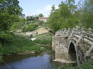
Mells is a village and civil parish in Somerset, England, near the town of Frome.
James Fussell IV (1748–1832) was an iron magnate operating the Old Iron Works, Mells in Vallis Vale between Mells and Great Elm in Somerset. He was a promoter of the Dorset and Somerset Canal and the inventor of both the roller chain and the balance lock.

Old Iron Works, Mells is a 0.25 hectare biological Site of Special Scientific Interest, in the Wadbury Valley, south of the village of Mells in Somerset, notified in 1987. The site is a ruined iron works, which mainly produced agricultural edge-tools that were exported all over the world, and is now, in addition to its unique and major importance in relation to industrial archaeology, used as a breeding site by horseshoe bats. The block of buildings adjacent to the entrance is listed Grade II* and most of the rest of the site is a Scheduled Ancient Monument. It is included in the Heritage at Risk Register produced by English Heritage.

Great Elm is a village and civil parish between Mells and Frome in the Mendip district of Somerset, England. The parish includes the hamlet of Hapsford.

Stoke St Michael is a village and civil parish on the Mendip Hills 4 miles (6.4 km) north east of Shepton Mallet, and 8 miles (12.9 km) west of Frome, in the Mendip district of Somerset, England.
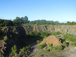
Fairy Cave Quarry is between Stoke St Michael and Oakhill in the limestone of the Mendip Hills, in Somerset, England.

The Church of the Holy Trinity at Chantry, in the parish of Whatley, Somerset, England, dates from 1844 to 1846. It was designed by George Gilbert Scott and William Moffatt, with further work by William George Brown of Frome, for James Fussell, who owned the Old Iron Works, Mells. It is a Grade I listed building.
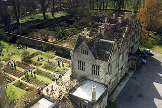
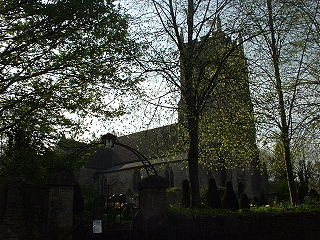
Mells Manor at Mells, Somerset, England, was built in the 16th century for Edward Horner, altered in the 17th century, partially demolished around 1780, and restored by Sir Edwin Lutyens in the 20th century. The house, along with the garden walls, has been designated as a Grade I listed building, and is closely associated with the adjacent Church of St Andrew. The gardens are listed, Grade I, on the Register of Historic Parks and Gardens of special historic interest in England.
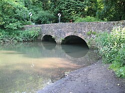
Murtry Aqueduct is a three-arched aqueduct that was intended to carry the Dorset and Somerset Canal over the Mells River, near Frome in Somerset, England. It is a grade II listed building.
Mendip is a local government district of Somerset in England. The Mendip district covers a largely rural area of 285 square miles (738 km2) ranging from the Mendip Hills through on to the Somerset Levels. It has a population of approximately 110,000. The administrative centre of the district is Shepton Mallet but the largest town is Frome.
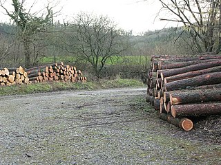
Harridge Wood is an area of woodland in Somerset, England. From about 1300 AD part of the wood was the scene of coal mining, which continued until around 1800. The traces of mining have been well preserved, and are now a scheduled site. The woodland is now part of the Harridge Woods Nature Reserve. Large areas were planted for timber in the mid-20th century, and this continues to be harvested. The nature reserve is steadily reintroducing the original flora.