
Bath is the largest city in the county of Somerset, England, known for and named after its Roman-built baths. In 2019, the population was 101,106. Bath is in the valley of the River Avon, 97 miles (156 km) west of London and 11 miles (18 km) southeast of Bristol. The city became a World Heritage Site in 1987, and was later added to the transnational World Heritage Site known as the "Great Spa Towns of Europe" in 2021.

Bridgwater is a large historic market town and civil parish in Somerset, England. Its population currently stands at around 41,276 as of 2022. Bridgwater is at the edge of the Somerset Levels, in level and well-wooded country. The town lies along both sides of the River Parrett; it has been a major inland port and trading centre since the industrial revolution. Most of its industrial bases still stand today. Its larger neighbour, Taunton, is linked to Bridgwater via a canal, the M5 motorway and the GWR railway line.

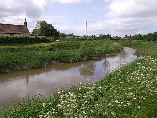
The River Parrett flows through the counties of Dorset and Somerset in South West England, from its source in the Thorney Mills springs in the hills around Chedington in Dorset. Flowing northwest through Somerset and the Somerset Levels to its mouth at Burnham-on-Sea, into the Bridgwater Bay nature reserve on the Bristol Channel, the Parrett and its tributaries drain an area of 660 square miles (1,700 km2) – about 50 per cent of Somerset's land area, with a population of 300,000.

The River Avon is a river in the south west of England. To distinguish it from a number of other rivers of the same name, it is often called the Bristol Avon. The name 'Avon' is a cognate of the Welsh word afon, meaning 'river'.

The Fosse Way was a Roman road built in Britain during the first and second centuries AD that linked Isca Dumnoniorum (Exeter) in the southwest and Lindum Colonia (Lincoln) to the northeast, via Lindinis (Ilchester), Aquae Sulis (Bath), Corinium (Cirencester), and Ratae Corieltauvorum (Leicester).
The River Tone is a river in the English county of Somerset. The river is about 33 kilometres (21 mi) long. Its source is at Beverton Pond near Huish Champflower in the Brendon Hills, and is dammed at Clatworthy Reservoir. The reservoir outfall continues through Taunton and Curry and Hay Moors, which are designated as a Site of Special Scientific Interest. Finally, it flows into the River Parrett at Burrowbridge.

The A38, parts of which are known as Devon Expressway, Bristol Road and Gloucester Road, is a major A-class trunk road in England.

Keynsham is a town and civil parish located between Bristol and Bath in Somerset, England. It has a population of 16,000. It was listed in the Domesday Book as Cainesham, which is believed to mean the home of Saint Keyne.

The River Aln runs through the county of Northumberland in England. It rises in Alnham in the Cheviot Hills and discharges into the North Sea at Alnmouth on the east coast of England.
The River Chew is a small river in England that flows for some 17 miles (27 km) through the North Somerset countryside to form the Chew Valley before merging with the River Avon.
The Allan Water is a river in central Scotland. Rising in the Ochil Hills, it runs through Strathallan to Dunblane and Bridge of Allan before joining the River Forth. It is liable to cause floods in lower Bridge of Allan.

The Monarch's Way is a 625-mile (1,006 km) long-distance footpath in England that approximates the escape route taken by King Charles II in 1651 after being defeated in the Battle of Worcester. It runs from Worcester via Bristol and Yeovil to Shoreham, West Sussex.

Alford is a village and parish on the River Alham, in Somerset, England, situated 8 miles (12.9 km) south of Shepton Mallet and two miles west of Castle Cary in the South Somerset district. The village has a population of 63.

Kentucky Route 80 (KY 80) is a 483.55-mile-long (778.20 km) state highway in the southern part of the U.S. state of Kentucky. The route originates on the state's western border at Columbus in Hickman County, and stretches across the southern portion of the state, terminating southeast of Elkhorn City on the Virginia state line. It is the longest Kentucky State Highway, though the official distance as listed in route logs is much less due to multiple concurrencies with U.S. Route 68 (US 68) and U.S. Route 23.

The River Brue originates in the parish of Brewham in Somerset, England, and reaches the sea some 50 kilometres (31 mi) west at Burnham-on-Sea. It originally took a different route from Glastonbury to the sea, but this was changed by Glastonbury Abbey in the twelfth century. The river provides an important drainage route for water from a low-lying area which is prone to flooding which man has tried to manage through rhynes, canals, artificial rivers and sluices for centuries.

Ditcheat is a village and civil parish 4.5 miles (7 km) south of Shepton Mallet, and 2.5 miles (4 km) north-west of Castle Cary, in the Mendip district of Somerset, England. Besides the village, the parish has four hamlets: Wraxall, Lower Wraxall, Alhampton and Sutton.

The Mells River flows through the eastern Mendip Hills in Somerset, England. It rises at Gurney Slade and flows east joining the River Frome at Frome.

The Cheddar Yeo is a small river in Somerset, England. Beneath the limestone of the Mendip Hills it forms the largest underground river system in Britain. After emerging into Cheddar Gorge it flows through the village of Cheddar, where it has been used in the past to power mills. From the Middle Ages until the 19th century the river had ports for seagoing vessels but is no longer navigable. Some of the water, which is of good quality, is diverted into Cheddar Reservoir to provide drinking water for Bristol.

The Land Yeo is a small river which flows through North Somerset, England.
Derventio was a Roman settlement at Papcastle on the river Derwent near Cockermouth, Cumbria, England. It was the site of a Roman fort, which was originally built in timber and rebuilt in stone. There was also a civilian settlement (vicus).
