
Exmoor is loosely defined as an area of hilly open moorland in west Somerset and north Devon in South West England. It is named after the River Exe, the source of which is situated in the centre of the area, two miles north-west of Simonsbath. Exmoor is more precisely defined as the area of the former ancient royal hunting forest, also called Exmoor, which was officially surveyed 1815–1818 as 18,810 acres (7,610 ha) in extent. The moor has given its name to a National Park, which includes the Brendon Hills, the East Lyn Valley, the Vale of Porlock and 55 km (34 mi) of the Bristol Channel coast. The total area of the Exmoor National Park is 692.8 km2 (267.5 sq mi), of which 71% is in Somerset and 29% in Devon.
Porlock is a coastal village in Somerset, England, 5 miles (8 km) west of Minehead. It has a population of 1,440.

Dunkery Beacon at the summit of Dunkery Hill is the highest point on Exmoor and in Somerset, England. It is also the highest point in southern England outside of Dartmoor.

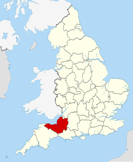
Somerset is a rural county in the southwest of England, covering 4,171 square kilometres (1,610 sq mi). It is bounded on the north-west by the Bristol Channel, on the north by Bristol and Gloucestershire, on the north-east by Wiltshire, on the south-east by Dorset, and on the south west and west by Devon. It has broad central plains with several ranges of low hills. The landscape divides into four main geological sections from the Silurian through the Devonian and Carboniferous to the Permian which influence the landscape, together with water-related features.

The River Barle runs from the Chains on northern Exmoor, in Somerset, England to join the River Exe at Exebridge, Devon. The river and the Barle Valley are both designated as biological Sites of Special Scientific Interest.

Dunster Working Watermill is a restored 18th century watermill, situated on the River Avill, close to Gallox Bridge, in the grounds of Dunster Castle in Dunster, Somerset, England. It is a Grade II* listed building.

Holnicote in the parish of Selworthy, West Somerset, England, is a historic estate consisting of 12,420 acres of land, much situated within the Exmoor National Park.

North Exmoor is a 12,005.3-hectare (29,666-acre) biological Site of Special Scientific Interest (SSSI) in Devon and Somerset, notified in 1954.
Oare is a village and civil parish on Oare Water on Exmoor in the Somerset West and Taunton district of Somerset, England. It is located 6 miles (10 km) east of Lynton and the parish includes the hamlet of Oareford and the village of Culbone which contains its own tiny church.

Winsford is a village and civil parish in Somerset, England, located about 5 miles (8 km) north-west of Dulverton.

Luccombe or Luckham is a village and civil parish in the Exmoor National Park in the English county of Somerset. It at the foot of the moor's highest hill, the 1,750 feet (533 m) Dunkery Beacon, and is about one mile south of the A39 road between Porlock and Minehead. Administratively it forms part of the district of Somerset West and Taunton. The parish includes the hamlets of Stoke Pero and Horner, as well as the former hamlet of Wilmersham.

Roadwater is a village 3 miles (5 km) south-west of Williton, on the northern edge of the Exmoor National Park, in Somerset, England.
The River Aller is a small river on Exmoor in Somerset, England.

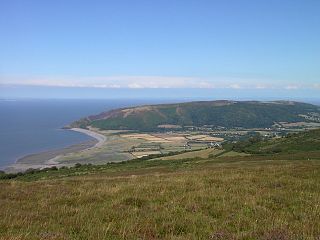
Selworthy is a small village and civil parish 5 kilometres (3 mi) from Minehead in Somerset, England. It is located in the National Trust's Holnicote Estate on the northern fringes of Exmoor. The parish includes the hamlets of Bossington, Tivington, Lynch, Brandish Street and Allerford.
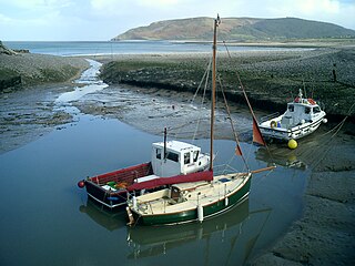
Porlock Bay is on the Bristol Channel, between Hurlstone Point and Porlock Weir in Somerset, England.
The county of Somerset is in South West England, bordered by the Bristol Channel and the counties of Bristol and Gloucestershire to the north, and Wiltshire to the east, Dorset to the south, and Devon to the west. The climate, influenced by its proximity to the Atlantic Ocean and the prevailing westerly winds, tends to be mild, damp and windy.

Hawkcombe Woods is a national nature reserve near Porlock on Exmoor, Somerset, England.

Porlock Stone Circle is a stone circle located on Exmoor, near the village of Porlock in the south-western English county of Somerset. The Porlock ring is part of a tradition of stone circle construction that spread throughout much of Britain, Ireland, and Brittany during the Late Neolithic and Early Bronze Age, over a period between 3300 and 900 BCE. The purpose of such monuments is unknown, although archaeologists speculate that the stones represented supernatural entities for the circles' builders.

Withypool Stone Circle, also known as Withypool Hill Stone Circle, is a stone circle located on the Exmoor moorland, near the village of Withypool in the southwestern English county of Somerset. The ring is part of a tradition of stone circle construction that spread throughout much of Britain, Ireland, and Brittany during the Late Neolithic and Early Bronze Age, over a period between 3300 and 900 BCE. The purpose of such monuments is unknown, although archaeologists speculate that the stones represented supernatural entities for the circle's builders.
West Somerset was a local government district in the English county of Somerset. It merged with Taunton Deane to form Somerset West and Taunton on 1 April 2019.
