Related Research Articles

The Gulf Coast of the United States, also known as the Gulf South or the South Coast, is the coastline along the Southern United States where they meet the Gulf of Mexico. The coastal states that have a shoreline on the Gulf of Mexico are Texas, Louisiana, Mississippi, Alabama, and Florida, and these are known as the Gulf States.
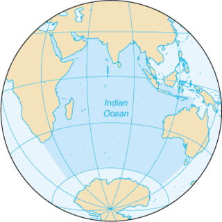
The Indian Ocean is the third-largest of the world's five oceanic divisions, covering 70,560,000 km2 (27,240,000 sq mi) or approx. 20% of the water on Earth's surface. It is bounded by Asia to the north, Africa to the west and Australia to the east. To the south it is bounded by the Southern Ocean, or Antarctica, depending on the definition in use. Along its core, the Indian Ocean has large marginal, or regional seas, such as the Andaman Sea, the Arabian Sea, the Bay of Bengal, and the Laccadive Sea.

The Nearctic realm is one of the eight biogeographic realms constituting the Earth's land surface.

The Atlantic Forest is a South American forest that extends along the Atlantic coast of Brazil from Rio Grande do Norte state in the northeast to Rio Grande do Sul state in the south and inland as far as Paraguay and the Misiones Province of Argentina, where the region is known as Selva Misionera.
A phytochorion, in phytogeography, is a geographic area with a relatively uniform composition of plant species. Adjacent phytochoria do not usually have a sharp boundary, but rather a soft one, a transitional area in which many species from both regions overlap. The region of overlap is called a vegetation tension zone.
A biodiversity hotspot is a biogeographic region with significant levels of biodiversity that is threatened by human habitation. Norman Myers wrote about the concept in two articles in The Environmentalist in 1988 and 1990, after which the concept was revised following thorough analysis by Myers and others into "Hotspots: Earth's Biologically Richest and Most Endangered Terrestrial Ecoregions" and a paper published in the journal Nature, both in 2000.
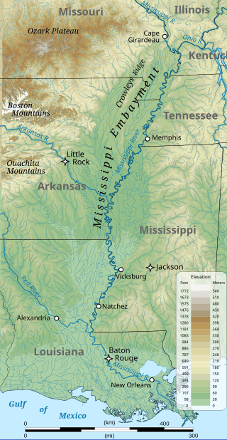
The Mississippi embayment is a physiographic feature in the south-central United States, part of the Mississippi Alluvial Plain. It is essentially a northward continuation of the fluvial sediments of the Mississippi River Delta to its confluence with the Ohio River at Cairo, Illinois. The current sedimentary area was formed in the Cretaceous and early Cenozoic by the filling with sediment of a pre-existing basin. An explanation for the embayment's formation was put forward by Van Arsdale and Cox in 2007: movement of the Earth's crust brought this region over a volcanic "hotspot" in the Earth's mantle causing an upthrust of magma which formed the Appalachian-Ouachita range. Subsequent erosion caused a deep trough that was flooded by the Gulf of Mexico and eventually filled with sediment from the Mississippi River.

The Gulf Coastal Plain extends around the Gulf of Mexico in the Southern United States and eastern Mexico.

The Sandhills or Carolina Sandhills is a 10-35 mi wide physiographic region within the U.S. Atlantic Coastal Plain province, along the updip (inland) margin of this province in the states of North Carolina, South Carolina, and Georgia. The extent of the Carolina Sandhills is shown in maps of the ecoregions of North Carolina, South Carolina, and Georgia.

Southwest Australia is a biogeographic region in Western Australia. It includes the Mediterranean-climate area of southwestern Australia, which is home to a diverse and distinctive flora and fauna.
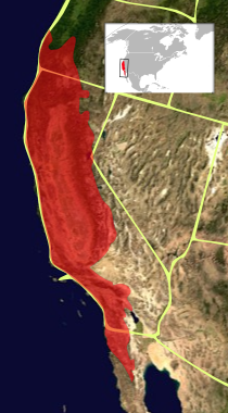
The California Floristic Province (CFP) is a floristic province with a Mediterranean-type climate located on the Pacific Coast of North America with a distinctive flora similar to other regions with a winter rainfall and summer drought climate like the Mediterranean Basin. This biodiversity hotspot is known for being the home of the Sierran giant sequoia tree and its close relative the coast redwood. In 1996, the Province was designated as a biodiversity hotspot allowing it to join ranks among 33 other areas in the world with many endemic species. To be named a biodiversity hotspot, an area has to contain species and plant life that cannot be found anywhere else in the world. The California Floristic Province is home to over 3,000 species of vascular plants, 60% of which are endemic to the province.

The Cape Floral Region is a floristic region located near the southern tip of South Africa. It is the only floristic region of the Cape Floristic Kingdom, and includes only one floristic province, known as the Cape Floristic Province.
North America is the third largest continent, and is also a portion of the third largest supercontinent if North and South America are combined into the Americas and Africa, Europe, and Asia are considered to be part of one supercontinent called Afro-Eurasia. With an estimated population of 580 million and an area of 24,709,000 km2 (9,540,000 mi2), the northernmost of the two continents of the Western Hemisphere is bounded by the Pacific Ocean on the west; the Atlantic Ocean on the east; the Caribbean Sea on the south; and the Arctic Ocean on the north.

The Atlantic Plain is one of eight distinct physiographic divisions of the contiguous United States. Using the USGS physiographic classification system, the Atlantic Plain division comprises two provinces and six sections. The Coastal Plain province is differentiated from the Continental Shelf province simply based on the portion of the land mass above and below sea level.

The North American Atlantic Region is a floristic region within the Holarctic Kingdom identified by Armen Takhtajan and Robert F. Thorne, spanning from the Atlantic and Gulf coasts to the Great Plains and comprising a major part of the United States and southeastern portions of Canada. It is bordered by the Circumboreal floristic region in the north, by the Rocky Mountain and Madrean floristic regions in the west and by the Caribbean floristic region of the Neotropical Kingdom in the south of Florida. The flora of the region comprises two endemic monotypic families, Hydrastidaceae and Leitneriaceae, and is characterized by about a hundred of endemic genera. The degree of species endemism is very high, many species are Tertiary relicts, which survived the Wisconsin glaciation and are now concentrated in the Appalachians and the Ozarks. A number of genera are shared only with the Canadian floristic province of the Circumboreal region. Moreover, as has long been noted, a large number of relict genera are shared with the relatively distant Eastern Asiatic Region and sometimes Southeast Asia. R. F. Thorne counted at least 74 genera restricted to eastern North America and Asia. The fossil record indicates that during the Tertiary period a warm temperate zone extended across much of the Northern Hemisphere, linking America to Asia.

The Maputaland-Pondoland-Albany Hotspot (MPA) is a biodiversity hotspot, a biogeographic region with significant levels of biodiversity, in Southern Africa. It is situated near the south-eastern coast of Africa, occupying an area between the Great Escarpment and the Indian Ocean. The area is named after Maputaland, Pondoland and Albany. It stretches from the Albany Centre of Plant Endemism in the Eastern Cape Province of South Africa, through the Pondoland Centre of Plant Endemism and KwaZulu-Natal Province, the eastern side of Eswatini and into southern Mozambique and Mpumalanga. The Maputaland Centre of Plant Endemism is contained in northern KwaZulu-Natal and southern Mozambique.
The Austroriparian is a biogeographic province in the Southeastern United States. As designated by Miklos Udvardy, it includes the humid coniferous and mixed temperate forests of the Mississippi Alluvial Plain and the Atlantic Coastal Plain from eastern Texas to southeastern Virginia, including all but the southernmost portion of Florida, and covering portions of Alabama, Arkansas, Florida, Georgia, Louisiana, Mississippi, Missouri, North Carolina, South Carolina, Tennessee, Texas.

Biogeographic classification of India is the division of India according to biogeographic characteristics. Biogeography is the study of the distribution of species (biology), organisms, and ecosystems in geographic space and through geological time. India has a rich heritage of natural diversity. India ranks fourth in Asia and tenth in the world amongst the top 17 mega-diverse countries in the world. India harbours nearly 11% of the world's floral diversity comprising over 17500 documented flowering plants, 6200 endemic species, 7500 medicinal plants and 246 globally threatened species in only 2.4% of world's land area. India is also home to four biodiversity hotspots—Andaman & Nicobar Islands, Eastern Himalaya, Indo-Burma region, and the Western Ghats. Hence the importance of biogeographical study of India's natural heritage.
The Appalachian Province is a floristic province within the North American Atlantic Region, a floristic region within the Holarctic Kingdom. It was historically covered by deciduous forest. The province includes southern Ontario and Quebec, down to central Georgia and Alabama. It includes most of Arkansas, part of eastern Texas, and stretches west through the Ouachita Mountains, Ozark Plateau, eastern Iowa, and southeastern Minnesota. It is bounded on the north by the Canadian Province, on the east and south by the Atlantic and Gulf Coastal Plain Province, and on the west by the North American Prairies Province.
The Biodiversity of South Africa is the variety of living organisms within the boundaries of South Africa and its exclusive economic zone. South Africa is a region of high biodiversity in the terrestrial and marine realms. The country is ranked sixth out of the world's seventeen megadiverse countries, and is rated among the top 10 for plant species diversity and third for marine endemism.
References
- ↑ Fill, Jennifer M.; Welch, Shane M.; Brown, Herrick; Waldron, Jayme L. (2014-01-01). "Life-History Correlates of Plant Endemism in Longleaf Pine Ecosystems (Figure 1)". Southeastern Naturalist. 13 (3): 484–492. doi:10.1656/058.013.0309. ISSN 1528-7092. S2CID 83808735 – via Researchgate.
- ↑ Takhtadzhi︠a︡n, A. L. (Armen Leonovich) (1986). Cronquist, Arthur (ed.). Floristic regions of the world. Translated by Crovello, Theodore J. Berkeley: University of California Press. pp. 90–95. ISBN 0-520-04027-9. OCLC 12135442.
- ↑ Thorne, Robert F. (2009-07-16). "Phytogeography of North America North of Mexico". Flora of North America . Vol. 1: Introduction. Archived from the original on 2017-08-25. Retrieved 2017-08-24.
- ↑ W. Henry McNab and Peter E. Avers (compilers) (July 1994). "Ecological Subregions of the United States (WO-WSA-5)" . Retrieved 2017-08-24.
- ↑ "Coastal Plain Province (U.S. National Park Service)". www.nps.gov. US National Park Service. 2018-04-30. Retrieved 2021-10-19.
- ↑ Noss, Reed (2016-02-18). "Announcing the World's 36th Biodiversity Hotspot: The North American Coastal Plain". Critical Ecosystem Partnership Fund. Archived from the original on 2018-02-11. Retrieved 2018-02-11.
| | This ecoregion article is a stub. You can help Wikipedia by expanding it. |
| | This botany article is a stub. You can help Wikipedia by expanding it. |