
Tornado intensity is the measure of wind speeds and potential risk produced by a tornado. Intensity can be measured by in situ or remote sensing measurements, but since these are impractical for wide-scale use, intensity is usually inferred by proxies, such as damage. The Fujita scale, Enhanced Fujita scale, and the International Fujita scale rate tornadoes by the damage caused. In contrast to other major storms such as hurricanes and typhoons, such classifications are only assigned retroactively. Wind speed alone is not enough to determine the intensity of a tornado. An EF0 tornado may damage trees and peel some shingles off roofs, while an EF5 tornado can rip well-anchored homes off their foundations, leaving them bare; even deforming large skyscrapers. The similar TORRO scale ranges from a T0 for extremely weak tornadoes to T11 for the most powerful known tornadoes. Doppler radar data, photogrammetry, and ground swirl patterns may also be analyzed to determine the intensity and assign a rating.

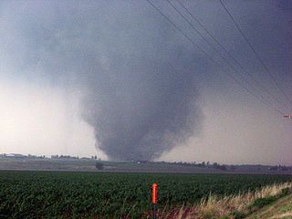
During the evening of June 22, 2007, a powerful F5 tornado struck the town of Elie, in the Canadian province of Manitoba. It was part of a small two-day tornado outbreak that occurred in the area and reached a maximum width of 150 yards (140 m). The tornado was unusual because it caused the extreme damage during its roping out stage at a mere 35 yards (32 m) in width and moved extremely slowly and unpredictably. The tornado tracked primarily southeast, as opposed to the usual northeast, and made multiple loops and sharp turns. Because Environment Canada adopted the Enhanced Fujita scale in 2013, there will be no more tornadoes with an F5 rating, making this tornado the first and last confirmed F5 tornado in Canada.

The 2008 Super Tuesday tornado outbreak was a deadly tornado outbreak which affected the Southern United States and the lower Ohio Valley on February 5 and 6, 2008. The event began on Super Tuesday, while 24 states in the United States were holding primary elections and caucuses to select the presidential candidates for the upcoming presidential election. Missouri, Illinois, Arkansas, Alabama, and Tennessee were among the affected regions in which primaries were being held. Some voting locations were forced to close early due to the approaching severe weather.

A tornado outbreak struck southern and central Poland on 15 August 2008. Overall, it killed four people. Tornadoes affected Opole Voivodeship, Silesian Voivodeship and Łódź Voivodeship. The European Storm Forecast Experiment issued a Level 3 which means there could potentially be a major severe thunderstorm outbreak.

From April 14–16, 2011, a tornado outbreak, among the largest recorded tornado outbreaks in U.S. history, produced 178 confirmed tornadoes across 16 states, resulting in severe destruction on all three days of the outbreak. A total of 38 people were killed from tornadoes and an additional five people were killed as a result of straight-line winds associated with the storm system. The outbreak of severe weather and tornadoes led to 43 deaths in the Southern United States. This was the largest number of fatalities in an outbreak in the United States since the 2008 Super Tuesday tornado outbreak. However, this outbreak was soon surpassed no more than two weeks later by the 2011 Super Outbreak, which killed 324 people.

The 2011 Super Outbreak was the largest, costliest, and one of the deadliest tornado outbreaks ever recorded, taking place in the Southern, Midwestern, and Northeastern United States from April 25 to 28, 2011, leaving catastrophic destruction in its wake. Over 175 tornadoes struck Alabama, Mississippi, and Tennessee, which were the most severely damaged states. Other destructive tornadoes occurred in Arkansas, Georgia, Kentucky, Louisiana, New York, and Virginia, with storms also affecting other states in the Southern and Eastern United States. In total, 360 tornadoes were confirmed by NOAA's National Weather Service (NWS) and Government of Canada's Environment Canada in 21 states from Texas to New York to southern Canada. Widespread and destructive tornadoes occurred on each day of the outbreak. April 27 was the most active day, with a record 216 tornadoes touching down that day from midnight to midnight CDT. Four of the tornadoes were rated EF5, which is the highest ranking on the Enhanced Fujita scale; typically these tornadoes are recorded no more than once a year.
The tornado outbreak sequence of May 21–26, 2011 was one of the largest tornado outbreaks on record which affected the Midwestern and Southern regions of the United States. Most of the tornadoes developed in a corridor from Lake Superior southwest to central Texas; isolated tornadoes occurred in other areas. An especially destructive tornado destroyed one-third of Joplin, Missouri, resulting in 158 deaths and over 1,000 injuries. The Joplin tornado is the deadliest in the U.S. since April 9, 1947, when an intense tornado killed 181 in the Woodward, Oklahoma, area. Tornado-related deaths also occurred in Arkansas, Kansas, Minnesota, and Oklahoma. Overall, the tornado outbreak resulted in 186 deaths, 8 of those non-tornadic, making it second only to the 2011 Super Outbreak as the deadliest since 1974, and the second costliest tornado outbreak in U.S. history behind that same April 2011 outbreak, with insured damage estimated at $4–7 billion.

A violent, high-end EF4 multiple-vortex tornado destroyed portions of Tuscaloosa and Birmingham, Alabama, as well as smaller communities and rural areas between the two cities, during the late afternoon and early evening of April 27, 2011. It is one of the costliest tornadoes on record. It was one of the 360 tornadoes in the 2011 Super Outbreak, the largest tornado outbreak in United States history. The tornado reached a maximum path width of 1.5 miles (2.4 km) during its track through Tuscaloosa, and once again when it crossed I-65 north of Birmingham, and attained estimated winds of 190 mph (310 km/h) shortly after passing through the city. It then went on to impact parts of Birmingham at high-end EF4 intensity before dissipating. This was the third tornado to strike the city of Tuscaloosa in the past decade, and the second in two weeks.

The 2011 Hackleburg–Phil Campbell tornado was an extremely deadly, violent, and long-tracked EF5 wedge tornado that devastated several towns in rural northern Alabama, before tearing through the northern suburbs of Huntsville and causing damage in rural portions of southern Tennessee on the afternoon and early evening of April 27, 2011. It was the deadliest tornado of the 2011 Super Outbreak, the largest tornado outbreak in United States history. The tornado reached a maximum width of 1.25 miles (2.01 km) and was estimated to have had peak winds of 210 mph (340 km/h). The tornado killed 72 people, making it the deadliest tornado in Alabama history, and injured at least 145 others. At the time, it was the deadliest tornado to strike the United States since the 1955 Udall, Kansas, tornado.

On Sunday, February 10, 2013, a large EF4 multiple-vortex wedge tornado devastated the cities of West Hattiesburg, Hattiesburg, and Petal, Mississippi. The tornado was one of eight that touched down in southern Mississippi and southwestern Alabama that day. It reached a maximum path width of 0.75 miles (1.21 km) in its path through the Hattiesburg area and reached estimated maximum sustained winds of 170 mph (270 km/h) in Oak Grove neighborhood of West Hattiesburg. It destroyed many structures and impacted University of Southern Mississippi and two high schools. Mississippi was declared a federal disaster area by President Barack Obama, and a state of emergency was issued by Mississippi Governor Phil Bryant.

A relatively widespread, damaging, and deadly tornado outbreak struck the central and southern United States in late April 2014. The storm complex responsible for the outbreak produced multiple long-track tornadoes – seven of which were deadly, causing 35 fatalities. One additional death occurred in Florida, due to severe flooding associated with this system.

This page documents notable tornadoes and tornado outbreaks worldwide in 2015. Strong and destructive tornadoes form most frequently in the United States, Bangladesh, Brazil and Eastern India, but they can occur almost anywhere under the right conditions. Tornadoes also develop occasionally in southern Canada during the Northern Hemisphere's summer and somewhat regularly at other times of the year across Europe, Asia, and Australia. Tornadic events are often accompanied with other forms of severe weather including strong thunderstorms, winds and hail.

The 2011 Smithville, Mississippi tornado was an extremely violent EF5 wedge tornado that devastated areas of rural Mississippi, including the town of Smithville, Mississippi during the afternoon of April 27, 2011, resulting in catastrophic damage and numerous fatalities. The tornado was a part of the 2011 Super Outbreak, the largest tornado outbreak in United States history. The tornado reached an estimated maximum width of 3⁄4 of a mile with wind speeds up to 205 mph (330 km/h).

A prolific and deadly winter tornado outbreak struck areas across the Southeast United States between January 21–23, 2017. Lasting just under two days, the outbreak produced a total of 81 tornadoes, cementing its status as the second-largest January tornado outbreak and the third-largest winter tornado outbreak since 1950. Furthermore, it was the largest outbreak on record in Georgia with 42 tornadoes confirmed in the state. The most significant tornadoes were three EF3 tornadoes that heavily damaged or destroyed portions of Hattiesburg, Mississippi, and Albany and Adel, Georgia. A total of 20 people were killed by tornadoes—mainly during the pre-dawn hours of the outbreak—making it the second-deadliest outbreak in January since 1950, behind the 1969 Hazlehurst, Mississippi tornado outbreak that killed 32 people. In addition, the tornado death toll was higher than the entire previous year. In the aftermath of the outbreak, relief organizations assisted in clean-up and aid distribution. Total economic losses from the event reached at least $1.3 billion.

A small but deadly tornado outbreak affected West and Middle Tennessee on the night of March 2 and into the morning of March 3, 2020, including a high-end EF3 tornado that hit Nashville and Mount Juliet, becoming the 6th costliest tornado in United States history, and a violent EF4 tornado that impacted areas in and just west of Cookeville. A total of 25 people were killed by the tornadoes, with an additional 309 being injured, and more than 70,000 lost electricity. The path of the Nashville tornado was very similar to the one that hit East Nashville in 1998. A few additional tornadoes were also confirmed in Alabama, southeastern Missouri, and western Kentucky. Total damage from the event reached $1.607 billion according to the National Centers for Environmental Information.

A widespread and deadly tornado outbreak affected the Southeastern United States on Easter Sunday and Monday, April 12–13, 2020. Several tornadoes were responsible for prompting tornado emergencies, including the first one to be issued by the National Weather Service in Charleston, South Carolina. A large squall line formed and tracked through the mid-Atlantic on April 13, prompting more tornado warnings and watches. A total of 15 watches were produced during the course of the event, two of which were designated Particularly Dangerous Situations.

A rare, violent, and deadly long-tracked tornado struck several villages in the Hodonín and Břeclav districts of the South Moravian Region of the Czech Republic in the evening of 24 June 2021, killing six people and injuring at least 200 others. The tornado struck seven municipalities, with the worst damage in the villages of Hrušky, Moravská Nová Ves, Mikulčice and Lužice.

A deadly late-season tornado outbreak, the deadliest on record in December, produced catastrophic damage and numerous fatalities across portions of the Southern United States and Ohio Valley from the evening of December 10 to the early morning of December 11, 2021. The event developed as a trough progressed eastward across the United States, interacting with an unseasonably moist and unstable environment across the Mississippi Valley. Tornado activity began in northeastern Arkansas, before progressing into Missouri, Illinois, Tennessee, and Kentucky.
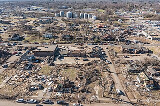
During the late evening of Friday, December 10, 2021, a violent, long-tracked EF4 tornado moved across Western Kentucky, producing severe to catastrophic damage in numerous towns, including Mayfield, Princeton, Dawson Springs, and Bremen. Crossing through eleven counties of the Jackson Purchase and Western Coal Field regions during its almost three-hour lifespan, the tornado was exceptionally long-tracked, traveling 165.6 miles (266.5 km) while at times becoming wrapped in rain. It was the deadliest and longest-tracked tornado in an outbreak that produced numerous strong tornadoes in several states; 57 fatalities were confirmed in the tornado. The second significant tornado in an exceedingly long-tracked tornado family, this tornado began just inside northern Obion County, Tennessee, a few miles after another long-tracked EF4 tornado – which traveled through northeast Arkansas, the Missouri Bootheel, and northwest Tennessee – dissipated in western Obion County.

An early-season tornado outbreak impacted the Southeastern United States on January 12, 2023. The result of a mid-level trough moving through, moisture and the presence of a strong low-level jet aided in the development of numerous severe and tornadic thunderstorms. Early in the outbreak, a strong EF2 tornado caused considerable damage in Winston County, Alabama, while another EF2 tornado struck just south of Greensboro. A destructive high-end EF2 tornado struck Selma, causing widespread damage and two injuries. The same storm produced a long-lived EF3 tornado that moved through or near Old Kingston, Titus, Equality, and Lake Martin, resulting in seven fatalities and several injuries in Autauga County alone. Another EF2 tornado from the storm struck areas in or around Five Points and Standing Rock before crossing into Georgia. After the dissipation of that tornado, nine more tornadoes, five of which were strong, caused heavy damage across west-central Georgia, especially in LaGrange, Griffin, and Experiment, the second one of which was impacted by four tornadoes in the span of 10 minutes, including two that were rated EF2 and EF3 respectively. Another EF2 tornado from the storm caused major damage and another fatality in the Jackson Lake area as well; an indirect death from the tornado also occurred the following day. Elsewhere, other tornadoes caused damage in Sumter and Mobile counties in Alabama, as well as parts of Mississippi, Tennessee, Kentucky, Illinois, and the Carolinas. In all, 41 tornadoes were confirmed.