Tropical Storm Fay (2008)

Last updated

Map key
  Tropical depression (≤38 mph, ≤62 km/h)
  Tropical storm (39–73 mph, 63–118 km/h)
  Category 1 (74–95 mph, 119–153 km/h)
  Category 2 (96–110 mph, 154–177 km/h)
  Category 3 (111–129 mph, 178–208 km/h)
  Category 4 (130–156 mph, 209–251 km/h)
  Category 5 (≥157 mph, ≥252 km/h)
  Unknown
Storm type
Disc Plain black.svg Tropical cyclone
Solid black.svg Subtropical cyclone
ArrowUp.svg Extratropical cyclone, remnant low, tropical disturbance, or monsoon depression

A tropical wave moved off the coast of Africa on August 7 without any significant convection, with an associated low pressure area moving southwestward away from the coast. It passed just south of the Cape Verde Islands, and tracked generally westward with a subtropical ridge centered to its north over the Azores. [4] Late on August 9, an area of convection developed in association with the wave. [5] With generally favorable conditions for development, the system began slowly organizing, [6] to the extent that on August 10, the National Hurricane Center (NHC) remarked for its potential to become a tropical depression in a few days. [7] By August 11, however, the thunderstorm activity became disorganized and limited, [8] though the next day convection reformed by the time it was located about 650 mi (1,050 km) east of the Lesser Antilles. [9] The hurricane hunters first flew into the system on August 12, though the flight only reported a broad area of low pressure. [10]

After the hurricane hunters' flight, the system became disorganized as environmental conditions became less favorable, [11] and by late on August 13 the convection was limited and well-removed from the low center. [12] The next day, thunderstorm activity increased and organized, [13] though another hurricane hunters flight confirmed the system did not develop into a tropical cyclone. [14] After passing over the northern Lesser Antilles, the system moved over the Virgin Islands and Puerto Rico, maintaining an area of deep convection. [15] It became better defined as it moved through the Mona Passage, and a hurricane hunters flight confirmed the presence of a closed circulation. A reconnaissance flight measured wind gusts of 56 miles per hour (90 km/h) and was designated as Tropical Storm Fay late on August 15 as the cyclone moved ashore along eastern Dominican Republic. [16] Initially, it was forecast to steadily intensify before and after crossing Cuba, later reaching minimal hurricane status in the eastern Gulf of Mexico; the HWRF hurricane model predicted for Fay to become a strong hurricane off the coast of western Florida. [17]

Tropical storm Fay causing heavy rainfall to Hispaniola Fay 15 August 2008 MODIS.jpg
Tropical storm Fay causing heavy rainfall to Hispaniola

Upon first becoming a tropical cyclone, Tropical Storm Fay was moving steadily westward over Hispaniola, influenced by a ridge to its north. [16] At around 1200  UTC on August 16, the storm emerged into the Gulf of Gonâve, [18] with little organized convection near the center. [19] Environmental conditions favored strengthening, and convection quickly developed over the center. [20] By early on August 17, a hurricane hunters flight reported a better organized circulation center, and satellite images displayed well-established outflow within a large convection envelope. [21] After passing near or over southwestern Granma Province in Cuba, upper-level wind shear increased slightly, and the convection diminished near the center. The storm turned more to the northwest, due to a trough weakening the ridge to its north. [22] However, at this time, the ECMWF forecast had Fay making landfall in Southwest Florida, crossing into the Atlantic, then tracking westward across the Florida Panhandle which is exactly what it would end up doing. [23]

Fay made four Florida landfalls, first at Key West in the late afternoon of August 18, then early the following morning at Cape Romano south of Naples as a 65 mph (105 km/h) tropical storm. [3] Later that day, while crossing central Florida, Fay unexpectedly strengthened over land to just under hurricane intensity with 70 mph (110 km/h) winds and a pressure of 986 mbar, [3] which is a stronger intensity than Fay had ever obtained over open ocean. According to some local meteorologists, Fay actually gained strength over Florida's inland waters, including the vast expanses of the Florida Everglades and Lake Okeechobee [24] The storm developed an eye feature, and continued to hold its strength for the rest of the day. [25] After many hours of land interaction, Fay began to weaken. [26] Fay regained some strength, however, after leaving land at Melbourne and heading northward over the warm Atlantic Ocean waters, only to be deflected westward as it encountered a high pressure ridge. This resulted in another landfall at Flagler Beach in the afternoon of August 21. Fay then emerged into the northeastern Gulf of Mexico and made its fourth landfall on the morning of August 23 near Carrabelle in the Florida Panhandle. Fay narrowly missed making yet another landfall, the center staying barely onshore while passing Panama City and St. Andrews Bay. Fay then weakened to a depression later that day. For the next several days, Fay was a slow moving tropical depression. Fay started moving to the northeast over southern Mississippi, where it moved over Alabama and finally dissipated on August 27 over Georgia.

Preparations

Tropical Storm Fay
Fay 19 aug 2008 1615Z Cropped.jpg
Tropical Storm Fay over Florida at peak strength on August 19

When advisories were first issued on Tropical Storm Fay late on August 15, tropical storm warnings were issued across the entire northern coast of the Hispaniola and Eastern Cuba as well as Southeastern Bahamas with tropical storm watches issued in parts of Northeastern Cuba and the Central Bahamas. [27] [28] The storm tracked far enough south for the Bahamas watches and warnings to be cancelled, but additional tropical storm warnings were issued for all of the coast Haiti. [29] [30] [31] [32] Additional tropical storm watches and warnings were issued in Jamaica, the Cayman Islands, Florida, Georgia, Alabama, Mississippi, and Louisiana. [33] [34] [35] [36] [37] [38] With Fay repeatedly being forecasted to become a hurricane, hurricane watches were issued in parts of Central Cuba as well as Southwestern Florida. [33] [29] [35] A hurricane warning was issued for Southwestern Florida on August 18. [39] Fay's unexpected strengthening over land prompted a hurricane watch to briefly be issued for Northeastern Florida and Southeastern Georgia on August 19. [36]

Impact

Caribbean

Deaths by country
Dominican Republic 4
Haiti 10
Jamaica 1
United States 21
Total36
Wettest tropical cyclones and their remnants in the Bahamas
Highest-known totals
PrecipitationStormLocationRef.
Rankmmin
1747.529.43 Noel 2007 Long Island [40]
2580.122.84 Dorian 2019 Hope Town [41]
3500.319.70 Matthew 2016 Matthew Town, Inagua [42]
4436.617.19 Flora 1963 Duncan Town [43]
5390.115.36 Inez 1966 Nassau Airport [43]
6337.113.27 Fox 1952 New Providence [43]
7321.112.64 Michelle 2001 Nassau [44]
8309.412.18 Erin 1995 Church Grove [45]
9260.09.88 Fay 2008 Freeport [46]
10236.79.32 Floyd 1999 Little Harbor Abacos [47]

On August 15, the weather disturbance that would become Fay made landfall on Hispaniola. The system developed into a tropical storm while producing heavy rains on the island, prompting a major flash flood threat. The storm caused minor damage in Dominican Republic including falling trees and flooding, this caused most of the flights into and out of the country to be canceled. [48] At least four people were killed after being swept away by flood waters in the Dominican Republic. [49]

In Haiti, Fay's winds and rainfall damaged the agricultural sector, including rice fields and banana crops. One person died after being swept away by flood-waters while trying to cross a swollen river. [50] Two infants were killed when a bus flipped in Haiti. [51] In total, ten deaths were blamed on Fay in Haiti. [52]

In Jamaica, one person was killed as a result of a vehicle being swept away in flood waters. [49] In total, 15 people died in the Caribbean. [2]

Despite making landfall in central Cuba, exact impact from Fay in that nation is unknown.

United States

Florida

Rainfall produced by Fay in the United States Fay 2008 rainfall.gif
Rainfall produced by Fay in the United States
Tropical Storm Fay strengthening and then weakening as it passes over south-central Florida, featuring a hurricane-like eye over land Fay Landfall FL up to 0045.gif
Tropical Storm Fay strengthening and then weakening as it passes over south-central Florida, featuring a hurricane-like eye over land

During seven days in Florida, August 18–24, 2008, eleven people died and thousands of homes plus roads were damaged, from 60 mph (97 km/h) winds and rain waters up to 5 feet (1.5 m) deep, [53] with flooded rivers or tornadoes, as Fay traveled through the entire state. Making initial landfall in the Florida Keys and coming ashore again in the Naples area, Fay then crossed the state and exited near New Smyrna Beach, coming onshore again near St. Augustine and Jacksonville, crossing the Panhandle and finally leaving the Pensacola area into Alabama, early on August 24. Returning from Mississippi towards Tennessee, Fay continued to dump heavy rains around Pensacola, Tallahassee, and Panama City even during August 25.

Flooding in east-central Florida Fay2008Flood 012.jpg
Flooding in east-central Florida

While Fay was moving across South-Central Florida, a tornado, rated EF2 on the Enhanced Fujita Scale, [54] took place after landfall in Wellington, Florida, where significant damage was reported including doors and windows blown off houses, many trees knocked down and reports of a weak building destroyed. [55] Another tornado damaged 51 homes with nine of them rendered uninhabitable in Barefoot Bay. [56] According to the St. Lucie County Public Safety Department, about 8,000 homes were damaged from flooding. [57] The city of Melbourne shattered a 50-year-old rainfall record after receiving 11 inches (28 cm) of rain in a 24‑hour period. [58] About 80 neighborhoods in Melbourne were flooded, and a "couple hundred" homes in southeast Melbourne were filled with three to four feet of water, according to a press statement. [59] One neighborhood was particularly hard hit: Lamplighter Village along John Rodes Boulevard in Melbourne, FL. The flooding was so extensive that Governor Charlie Crist personally visited the neighborhood to assess the damage. A tornado touched down in Stuart on U.S. 1 at Monroe Street, flipping a truck and damaging a gas station. [60] A 28-year-old kite surfer was critically injured in Fort Lauderdale when winds associated with a Tropical Storm Fay feeder band slammed him face-first into the ground and then dragged him across the streets until he hit a building, which was filmed by a WFOR camera crew. [61]

Flooding on Merritt Island, Florida during Tropical Storm Fay Flood 021 levelled.jpg
Flooding on Merritt Island, Florida during Tropical Storm Fay

Areas of the state received up to 25 inches (64 cm) of rain, causing serious flooding. Native wildlife, including alligators, were seen in flooded neighborhoods after high water forced them from their habitat. Hundreds of homes were flooded in Brevard and St. Lucie counties; some locations were inundated with up to 5 feet (1.5 m) of standing water. [62] Early estimates from Brevard county show $10 to $12 million in damages to homes and infrastructure. [59] Tropical Storm Fay resulted in the drowning of one person swimming off Neptune Beach and another swimmer in Duval County. Meanwhile, another 3 were killed in traffic accidents. [63] On August 21, President George W. Bush declared the entire state of Florida a Federal Disaster Area. [64] Seminole County also got hard hit by floods. Seminole County Public Schools were closed due to many roads being impassable. Many rivers in the county such as the St. Johns River, the Econlockhatchee River, and the Little Econlockhatchee River jumped their banks. Riverside Park in Oviedo was under four feet of flood water due to the Little Econlockhatchee River. On the evening of August 22, a tornado damaged four homes and a bridge in Lake Wales. [65]

After moving into the Florida Panhandle, five more people were killed as a result of Fay in Florida (all indirect), [66] including an electrocution which happened to an electrical worker doing repairs in Gadsden County. [67]

Georgia, Alabama, Mississippi

Fay over the southeastern United States on August 23 Fay 23 aug 2008 1910Z.jpg
Fay over the southeastern United States on August 23

Heavy rain was also reported in parts of Alabama, Georgia and Mississippi. A young boy was killed in Grady County, Georgia when he was swept away in a drainage ditch by floodwaters. [68] Another drowning death took place in Elmore County, Alabama as a result of the weakening Fay. [69] On August 22, 2008, radio station WNUZ, located in Alabama, "suffered direct lightning strikes" during Fay which resulted in "the complete destruction of the station's transmitter" and caused unspecified damage to other electrical broadcast equipment at the station. [70] The station applied to the Federal Communications Commission (FCC) for authority to stay silent while their engineers repaired or replaced the damaged gear and evaluated the station's other equipment. On December 24, 2008, WNUZ was granted permission to remain off the air until no later than June 22, 2009. [70] [71]

Fay persisted as a tropical storm from its first landfall until weakening to a tropical depression on August 23. It eventually weakened to a remnant low over Alabama on August 26, from which 8 tornadoes were spawned in Alabama and 6 in Georgia, injuring two in Commerce, Georgia. [72] [73]

High winds damaged the water tower in Midway, Alabama, compounding problems the town was experiencing with its water wells. A loan from the National Rural Water Association and assistance from Alabama Rural Water Association allowed Midway to make repairs and maintain the water supply. [74] The heavy and persistent rains associated with Fay, however, helped to temporarily alleviate extreme drought conditions over northern Georgia, northern Alabama, and eastern Tennessee. [75]

Elsewhere

Heavy rains in Tennessee triggered flash flooding throughout eastern portions of the state. [76] In Shelby County, flooding covered several cars, trapping several people. In all, Fay caused $20,000 in damages in Tennessee. [77] Rains in South Carolina caused a bridge in York County to collapse, leaving $100,000 in damages. [78] Severe flooding in North Carolina, particularly in Mecklenburg County damaged numerous homes. Near Charlotte, 148 buildings sustained major damage from floodwaters and numerous roads were shut down due to high waters. Damage in Mecklenburg alone amounted to $8.5 million. [79] In Cabarrus County, 14 swift water rescues were undertaken due to cars being stranded in flooded roads. About 70 homes were damaged in the county, leaving $1 million in damages. [80] Damages to roads in the county were estimated at $5.5 million. [81] In all, Fay caused roughly $15 million in damage in North Carolina. [79] [80] [81]

Records

Fay was the first storm on record to hit the same U.S. state on four separate occasions, beating a record set by Hurricane Gordon of 1994, and was just the third storm on record to hit the U.S. at least 3 times, the third was Hurricane Juan in 1985, although Juan did not hit the same state three times; one of its landfalls was in Alabama, and the other 2 were in Louisiana. [82] Fay was the first storm to prompt storm warnings for the entire coast of Florida; the four separate landfalls were responsible for every stretch of the Florida coast to receive a Tropical Storm Watch or Warning, or a Hurricane Watch or Warning. [83]

The two highest rainfall amounts recorded were 27.65 inches (702 mm) at Windover Farms, 8 miles (13 km) northwest of Melbourne, Florida, and 27.50 inches (698 mm) at Thomasville, Georgia.

See also

Related Research Articles

<span class="mw-page-title-main">2002 Atlantic hurricane season</span> Hurricane season in the Atlantic Ocean

The 2002 Atlantic hurricane season was a near-average Atlantic hurricane season. It officially started on June 1, 2002, and ended on November 30, dates which conventionally limit the period of each year when most tropical cyclones develop in the Atlantic Ocean. The season produced fourteen tropical cyclones, of which twelve developed into named storms; four became hurricanes, and two attained major hurricane status. While the season's first cyclone did not develop until July 14, activity quickly picked up: eight storms developed in the month of September. It ended early however, with no tropical storms forming after October 6—a rare occurrence caused partly by El Niño conditions. The most intense hurricane of the season was Hurricane Isidore with a minimum central pressure of 934 mbar, although Hurricane Lili attained higher winds and peaked at Category 4 whereas Isidore only reached Category 3. However, Lili had a minimum central pressure of 938 mbar.

<span class="mw-page-title-main">2008 Atlantic hurricane season</span> Hurricane season in the Atlantic Ocean

The 2008 Atlantic hurricane season was the most destructive Atlantic hurricane season since 2005, causing over 1,000 deaths and nearly $50 billion in damage. The season ranked as the third costliest ever at the time, but has since fallen to ninth costliest. It was an above-average season, featuring sixteen named storms, eight of which became hurricanes, and five which further became major hurricanes. It officially started on June 1 and ended on November 30. These dates conventionally delimit the period of each year when most tropical cyclones form in the Atlantic basin. However, the formation of Tropical Storm Arthur caused the season to start one day early. It was the only year on record in which a major hurricane existed in every month from July through November in the North Atlantic. Bertha became the longest-lived July tropical cyclone on record for the basin, the first of several long-lived systems during 2008.

<span class="mw-page-title-main">Tropical Storm Helene (2000)</span> Atlantic tropical storm in 2000

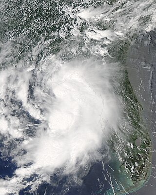
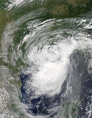
Tropical Storm Helene was a long-lived tropical cyclone that oscillated for ten days between a tropical wave and a 70 mph (110 km/h) tropical storm. It was the twelfth tropical cyclone and eighth tropical storm of the 2000 Atlantic hurricane season, forming on September 15 east of the Windward Islands. After degenerating into a tropical wave, the system produced flooding and mudslides in Puerto Rico. It reformed into a tropical depression on September 19 south of Cuba, and crossed the western portion of the island the next day while on the verge of dissipation. However, it intensified into a tropical storm in the Gulf of Mexico, reaching its peak intensity while approaching the northern Gulf Coast.

<span class="mw-page-title-main">Tropical Storm Bertha (2002)</span> Atlantic tropical storm in 2002

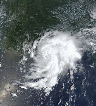
Tropical Storm Bertha was a minimal tropical storm that made landfall twice along the Gulf Coast of the United States in August 2002. The second tropical storm of the 2002 Atlantic hurricane season, Bertha developed in the northern Gulf of Mexico out of a trough of low pressure that extended into the Atlantic on August 4. It quickly organized and reached tropical storm strength before making landfall on southeastern Louisiana. Bertha turned to the southwest over the state, and re-entered the Gulf of Mexico on August 7. It remained disorganized due to proximity to land, and after making landfall on south Texas, Bertha dissipated on August 9.

<span class="mw-page-title-main">Tropical Storm Edouard (2002)</span> Atlantic tropical cyclone

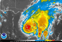
Tropical Storm Edouard was the first of eight named storms to form in September 2002, the most such storms in the North Atlantic for any month at the time. The fifth tropical storm of the 2002 Atlantic hurricane season, Edouard developed into a tropical cyclone on September 1 from an area of atmospheric convection associated with a cold front east of Florida. Under weak steering currents, Edouard drifted to the north and executed a clockwise loop to the west. Despite moderate to strong levels of wind shear, the storm reached a peak intensity of 65 mph (105 km/h) on September 3, but quickly weakened as it tracked westward. Edouard made landfall on northeastern Florida on September 5, and after crossing the state it dissipated on September 6 while becoming absorbed into the larger circulation of Tropical Storm Fay.

<span class="mw-page-title-main">Tropical Storm Claudette (2009)</span> Atlantic tropical storm in 2009

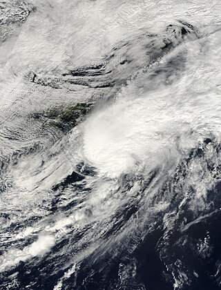
Tropical Storm Claudette was the third named storm of the 2009 Atlantic hurricane season and the first tropical cyclone of 2009 to affect the United States. Forming out of a tropical wave and an upper-level low pressure system on August 16, Claudette quickly intensified into a tropical storm offshore south of Tallahassee, Florida. By the afternoon, the storm had attained winds of 60 mph (97 km/h) and steadily tracked towards the Florida Panhandle. Early on August 17, the center of Claudette made landfall on Santa Rosa Island. Several hours after landfall, the storm weakened to a tropical depression and the Hydrometeorological Prediction Center took over primary responsibility of the storm. Later on August 17, the final public advisory was issued on the system as it dissipated over Alabama.

<span class="mw-page-title-main">2021 Pacific hurricane season</span> Hurricane season in the Pacific Ocean

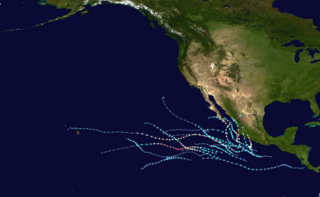
The 2021 Pacific hurricane season was a moderately active Pacific hurricane season, with above-average activity in terms of number of named storms, but below-average activity in terms of major hurricanes, as 19 named storms, 8 hurricanes, and 2 major hurricanes formed in all. It also had a near-normal accumulated cyclone energy (ACE). The season officially began on May 15, 2021 in the Eastern Pacific Ocean, and on June 1, 2021, in the Central Pacific in the Northern Hemisphere. The season ended in both regions on November 30, 2021. These dates historically describe the period each year when most tropical cyclogenesis occurs in these regions of the Pacific and are adopted by convention. However, the formation of tropical cyclones is possible at any time of the year, as illustrated by the formation of Tropical Storm Andres on May 9, which was the earliest forming tropical storm on record in the Eastern Pacific. Conversely, 2021 was the second consecutive season in which no tropical cyclones formed in the Central Pacific.

<span class="mw-page-title-main">Hurricane Barry (2019)</span> Category 1 Atlantic hurricane in 2019

Hurricane Barry was an asymmetrical Category 1 hurricane that was the wettest tropical cyclone on record in Arkansas and the fourth-wettest in Louisiana. The second tropical or subtropical storm and first hurricane of the 2019 Atlantic hurricane season, Barry originated as a mesoscale convective vortex over southwestern Kansas on July 2. The system eventually emerged into the Gulf of Mexico from the Florida Panhandle on July 10, whereupon the National Hurricane Center (NHC) designated it as a potential tropical cyclone. Early on July 11, the system developed into a tropical depression, and strengthened into a tropical storm later that day. Dry air and wind shear caused most of the convection, or thunderstorms, to be displaced south of the center. Nevertheless, Barry gradually intensified. On July 13, Barry attained its peak intensity as Category 1 hurricane with 1-minute sustained winds of 75 mph (120 km/h) and a minimum central pressure of 993 millibars (29.3 inHg). At 15:00 UTC, Barry made its first landfall at Marsh Island, and another landfall in Intracoastal City, Louisiana, both times as a Category 1 hurricane. Barry quickly weakened after landfall, falling to tropical depression status on July 15. The storm finally degenerated into a remnant low over northern Arkansas on the same day, subsequently opening up into a trough on July 16. The storm's remnants persisted for another few days, while continuing its eastward motion, before being absorbed into another frontal storm to the south of Nova Scotia on July 19.

<span class="mw-page-title-main">Tropical Storm Nestor (2019)</span> Atlantic tropical storm in 2019

Tropical Storm Nestor was a large but short-lived and disorganized tropical storm which caused widespread tornadoes and heavy rain in the Southeastern United States during mid-October 2019. The sixteenth depression and fourteenth named storm of the erratic 2019 Atlantic hurricane season, Nestor originated from a broad area of low pressure over the Western Caribbean. It emerged in the Gulf of Mexico and began to organize slightly, becoming Potential Tropical Cyclone Sixteen due to its threat to the Southeastern United States. It gained a sufficient enough of a circulation to be designated Tropical Storm Nestor near the Florida Panhandle early on October 18, crawling to the northeast, and then finally transitioning into an extratropical cyclone due to strong shear from a nearby upper-level low before making landfall on the Florida Panhandle on October 19.

<span class="mw-page-title-main">Tropical Storm Fay (2020)</span> Atlantic tropical storm in 2020

Tropical Storm Fay was the first tropical cyclone to make landfall in the U.S state of New Jersey since Hurricane Irene in 2011. The sixth named storm of the very active 2020 Atlantic hurricane season, Fay was the earliest sixth named storm on record in the basin when it formed on July 9. Fay originated from a surface low that formed over the Northern Gulf of Mexico on July 3 and slowly drifted eastward, before crossing over the Florida Panhandle. The system subsequently drifted across the Southeastern United States as a well-defined low pressure system, before emerging off the coast of North Carolina on July 8. From there, the storm utilized favorable conditions for development, or tropical cyclogenesis, and coalesced into a tropical storm on July 9. The storm intensified, reaching its peak intensity on July 10, with maximum 1-minute sustained winds of 60 mph (97 km/h) and a minimum central pressure of 998 millibars (29.5 inHg). While moving northward, Fay made landfall on New Jersey later that day. After making landfall, the storm quickly lost most of its organization and rapidly transitioned into a post-tropical cyclone over New York on July 11, before being absorbed by a larger extratropical low over Quebec on July 12.

<span class="mw-page-title-main">Hurricane Dolores (2015)</span> Category 4 Pacific hurricane in 2015

Hurricane Dolores was a powerful and moderately damaging tropical cyclone whose remnants brought record-breaking heavy rains and strong winds to California. The seventh named storm, fourth hurricane, and third major hurricane of the record-breaking 2015 Pacific hurricane season, Dolores formed from a tropical wave on July 11. The system gradually strengthened, attaining hurricane status on July 13. Dolores rapidly intensified as it neared the Baja California peninsula, finally peaking as a Category 4 hurricane on the Saffir–Simpson scale with winds of 130 mph (215 km/h) on July 15. An eyewall replacement cycle began and cooler sea-surface temperatures rapidly weakened the hurricane, and Dolores weakened to a tropical storm two days later. On July 18, Dolores degenerated into a remnant low west of the Baja California peninsula.

<span class="mw-page-title-main">Hurricane Isaias</span> Category 1 Atlantic hurricane in 2020

Hurricane Isaias was a destructive Category 1 hurricane that caused extensive damage across the Caribbean and the East Coast of the United States while also spawning the strongest tropical cyclone-spawned tornado since Hurricane Rita in 2005. The ninth named storm and second hurricane of the extremely active and record-breaking 2020 Atlantic hurricane season, Isaias originated from a vigorous tropical wave off the coast of Africa that was first identified by the National Hurricane Center on July 23. The tropical wave gradually became more organized and obtained gale-force winds on July 28 before organizing into Tropical Storm Isaias on July 30. Isaias marked the earliest ninth named storm on record, surpassing 2005's Hurricane Irene by eight days. Isaias strengthened into a Category 1 hurricane on the next day, reaching an initial peak of 85 mph (137 km/h), with a minimum central pressure of 987 mbar. On August 1, the storm made landfall on North Andros, Bahamas and subsequently weakened to a tropical storm, before paralleling the east coast of Florida and Georgia. As Isaias approached the Carolina coastline, it reintensified back into a hurricane. Soon afterward, Isaias reached its peak intensity, with maximum 1-minute sustained winds of 90 mph (140 km/h) and a minimum central pressure of 986 millibars (29.1 inHg), before making landfall near Ocean Isle Beach, North Carolina, at 03:10 UTC on August 4, at the same intensity. The storm proceeded to accelerate up the East Coast of the United States as a strong tropical storm, before transitioning into an extratropical cyclone over Quebec on August 4. Isaias's extratropical remnants persisted for another day, before dissipating on August 5.

<span class="mw-page-title-main">Hurricane Marco (2020)</span> Category 1 Atlantic hurricane in 2020

Hurricane Marco was the first of two tropical cyclones to threaten the Gulf Coast of the United States within a three-day period. The thirteenth named storm and third hurricane of the record-breaking 2020 Atlantic hurricane season, Marco developed from a fast-moving tropical wave west of the Windward Islands and south of Jamaica on August 20. The fast motion of the wave inhibited intensification initially, but as the wave slowed down and entered a more favorable environment, the system developed into a tropical depression, which in turn rapidly intensified into a strong tropical storm. Due to strong wind shear, Marco's intensification temporarily halted. However, after entering the warm waters of the Gulf of Mexico on August 23, Marco briefly intensified into a hurricane, only to quickly weaken later that evening due to another rapid increase in wind shear. Marco subsequently weakened to a tropical depression before degenerating into a remnant low early the next morning. Marco's remnants subsequently dissipated on August 26.

<span class="mw-page-title-main">Hurricane Sally</span> Category 2 Atlantic hurricane in 2020

Hurricane Sally was a destructive and slow-moving Atlantic hurricane that was the first hurricane to make landfall in the U.S. state of Alabama since Ivan in 2004, coincidentally on the same date in the same place. The eighteenth named storm and seventh hurricane of the extremely active 2020 Atlantic hurricane season, Sally developed from an area of disturbed weather which was first monitored over the Bahamas on September 10. The system grew a broad area of low-pressure on September 11, and was designated as a tropical depression late that day. Early the next day, the depression made landfall at Key Biscayne and subsequently strengthened into Tropical Storm Sally that afternoon. Moderate northwesterly shear prevented significant intensification for the first two days, but convection continued to grow towards the center and Sally slowly intensified. On September 14, a center reformation into the center of the convection occurred, and data from a hurricane hunter reconnaissance aircraft showed that Sally had rapidly intensified into a strong Category 1 hurricane. However, an increase in wind shear and upwelling of colder waters halted the intensification and Sally weakened slightly on September 15 before turning slowly northeastward. Despite this increase in wind shear, it unexpectedly re-intensified, reaching Category 2 status early on September 16 before making landfall at peak intensity at 09:45 UTC on September 16, near Gulf Shores, Alabama, with maximum sustained winds of 110 mph (180 km/h) and a minimum central pressure of 965 millibars (28.5 inHg). The storm rapidly weakened after landfall before transitioning into an extratropical low at 12:00 UTC the next day. Sally's remnants lasted for another day as they moved off the coast of the Southeastern United States before being absorbed into another extratropical storm on September 18.

<span class="mw-page-title-main">Tropical Storm Beta (2020)</span> Atlantic tropical storm in 2020

Tropical Storm Beta was a tropical cyclone that brought heavy rainfall, flooding, and severe weather to the Southeastern United States in September 2020. The twenty-third tropical depression and twenty-third named storm of the record-breaking 2020 Atlantic hurricane season, Beta originally formed from a trough of low pressure that developed in the northeastern Gulf of Mexico on September 10. The low moved slowly southwestward, with development hampered initially by the development of nearby Hurricane Sally. After Sally moved inland over the Southeastern United States and weakened, the disturbance became nearly stationary in the southwestern Gulf, where it began to organize. By September 16, the storm had gained a low-level circulation center and had enough organization to be designated as Tropical Depression Twenty-Two. The system held its intensity for a day due to the influence of strong wind shear and dry air, before eventually attaining tropical storm strength. It slowly moved northward and intensified to a mid-range tropical storm before dry air and wind shear halted its intensification. Beta then became nearly stationary on September 19, before starting to move west towards the Texas coast the next day, weakening as it approached. On September 21, Beta made landfall near Matagorda Peninsula, Texas as a minimal tropical storm. It subsequently weakened to a tropical depression the next day before becoming post-tropical early on September 23. Its remnants moved northeastward, before the center elongated and merged with a cold front early on September 25.

<span class="mw-page-title-main">Hurricane Delta</span> Category 4 Atlantic hurricane in 2020

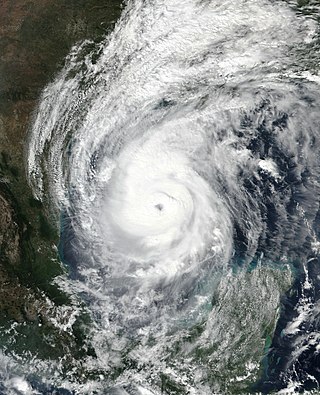
Hurricane Delta was the record-tying fourth named storm of 2020 to make landfall in Louisiana, as well as the record-breaking tenth named storm to strike the United States in that year. The twenty-sixth tropical cyclone, twenty-fifth named storm, tenth hurricane, and third major hurricane of the record-breaking 2020 Atlantic hurricane season, Delta formed from a tropical wave which was first monitored by the National Hurricane Center (NHC) on October 1. Moving westward, the tropical wave began to quickly organize. A well-defined center of circulation formed with sufficiently organized deep convection on October 4, and was designated as Tropical Depression Twenty-six and soon thereafter, Tropical Storm Delta. Extremely rapid intensification ensued throughout October 5 into October 6, with Delta becoming a Category 4 hurricane within 28 hours of attaining tropical storm status. The rate of intensification was the fastest in the Atlantic basin since Hurricane Wilma in 2005. After peaking in intensity however, an unexpected increase in wind shear and dry air quickly weakened the small storm before it made landfall in Puerto Morelos, Mexico as a Category 2 hurricane with 105 mph (169 km/h) winds. It weakened some more over land before emerging into the Gulf of Mexico, where it was downgraded to a Category 1 hurricane. After that, it began to restrengthen, regaining Category 3 status late on October 8. It then turned northward and reached a secondary peak intensity of 953 mbar (28.14 inHg) and winds of 120 mph early on October 9. Delta then began to turn more north-northeastward into an area of cooler waters, higher wind shear, and dry air, causing it to weaken back to Category 2 status. Delta then made landfall at 23:00 UTC near Creole, Louisiana with winds of 100 mph (160 km/h) and a pressure of 970 mbar (29 inHg). The storm began to weaken more rapidly after landfall, becoming post-tropical just 22 hours later.

<span class="mw-page-title-main">Tropical Storm Claudette (2021)</span> Atlantic tropical storm in 2021

Tropical Storm Claudette was a weak tropical cyclone that caused heavy rain and tornadoes across the Southeastern United States in June 2021, leading to severe damage. The third named storm of the 2021 Atlantic hurricane season, Claudette originated from a broad trough of low pressure over the Bay of Campeche on June 12. The disturbance moved erratically over the region for the next several days, before proceeding northward with little development due to unfavorable upper-level winds and land interaction. Despite this, the National Hurricane Center (NHC) initiated advisories on it as a Potential Tropical Cyclone late on June 17, due to its imminent threat to land. The disturbance finally organized into Tropical Storm Claudette at 00:00 UTC on June 19 just before landfall in southeast Louisiana. Claudette weakened to a depression as it turned east-northeastward before moving through Mississippi, Alabama, Georgia, and South Carolina. Baroclinic forcing then caused Claudette to reintensify into a tropical storm over North Carolina early on June 21 before it accelerated into the Atlantic Ocean later that day. Soon afterward, it degenerated into a low-pressure trough on the same day, before being absorbed into another extratropical cyclone on the next day.

<span class="mw-page-title-main">Tropical Storm Fred (2021)</span> Atlantic tropical storm in 2021

Tropical Storm Fred was a strong tropical storm which affected much of the Greater Antilles and the Southeastern United States in August 2021. The sixth tropical storm of the 2021 Atlantic hurricane season, Fred originated from a tropical wave first noted by the National Hurricane Center on August 4. As the wave drifted westward, advisories were initiated on the wave as a potential tropical cyclone by August 9 as it was approaching the Leeward Islands. Entering the Eastern Caribbean Sea after a close pass to Dominica by the next day, the potential tropical cyclone continued northwestward. By August 11, the disturbance had formed into Tropical Storm Fred just south of Puerto Rico, shortly before hitting the Dominican Republic on the island of Hispaniola later that day. The storm proceeded to weaken to a tropical depression over the highly mountainous island, before emerging north of the Windward Passage on August 12. The disorganized tropical depression turned to the west and made a second landfall in Northern Cuba on August 13. After having its circulation continuously disrupted by land interaction and wind shear, the storm degenerated into a tropical wave as it was turning northward near the western tip of Cuba the following day. Continuing north, the remnants of Fred quickly re-organized over the Gulf of Mexico, regenerating into a tropical storm by August 15. Fred continued towards the Florida Panhandle and swiftly intensified to a strong 65 mph (105 km/h) tropical storm before making landfall late on August 16 and moving into the state of Georgia. Afterward, Fred continued moving north-northeastward, before degenerating into an extratropical low on August 18. Fred's remnants later turned eastward, and the storm's remnants dissipated on August 20, near the coast of Massachusetts.

References

  1. "Fay's 4th Florida landfall is one for record books", By BRENDAN FARRINGTON, Associated Press Writer, August 23, 2008
  2. 1 2 Brent Kallestad (August 26, 2008). "Fay's Lasting Wrath". The Press Democrat. Archived from the original on August 27, 2008. Retrieved August 26, 2008.
  3. 1 2 3 Stewart/Beven (February 8, 2009). "Tropical Cyclone Report: Tropical Storm Fay" (PDF). National Hurricane Center . Retrieved February 9, 2009.
  4. Gladys Rubio (August 7, 2008). "Tropical Weather Discussion (2)". National Hurricane Center. Retrieved August 15, 2008.[ dead link ]
  5. Blake (August 9, 2008). "Tropical Weather Outlook". National Hurricane Center. Retrieved August 15, 2008.[ dead link ]
  6. Knabb (August 10, 2008). "Tropical Weather Outlook". National Hurricane Center. Retrieved August 15, 2008.[ dead link ]
  7. Blake (August 10, 2008). "Tropical Weather Outlook (2)". National Hurricane Center. Retrieved August 15, 2008.[ dead link ]
  8. Rhome (August 11, 2008). "Tropical Weather Outlook". National Hurricane Center. Retrieved August 15, 2008.[ dead link ]
  9. Rhome/Brown (August 12, 2008). "Tropical Weather Outlook". National Hurricane Center. Retrieved August 15, 2008.[ dead link ]
  10. Blake/Franklin (August 12, 2008). "Special Tropical Disturbance Statement". National Hurricane Center. Archived from the original on October 5, 2008. Retrieved August 15, 2008.{{cite web}}: CS1 maint: unfit URL (link)
  11. Brown/Pasch (August 13, 2008). "Tropical Weather Outlook". National Hurricane Center. Retrieved August 15, 2008.[ dead link ]
  12. Franklin (August 13, 2008). "Tropical Weather Outlook (2)". National Hurricane Center. Retrieved August 15, 2008.[ dead link ]
  13. Knabb (August 14, 2008). "Tropical Weather Outlook (2)". National Hurricane Center. Retrieved August 15, 2008.[ dead link ]
  14. Beven (August 14, 2008). "Special Tropical Disturbance Statement". National Hurricane Center. Archived from the original on October 5, 2008. Retrieved August 15, 2008.{{cite web}}: CS1 maint: unfit URL (link)
  15. Knabb (August 15, 2008). "Tropical Weather Outlook". National Hurricane Center. Retrieved August 15, 2008.[ dead link ]
  16. 1 2 Beven (August 15, 2008). "Tropical Storm Fay Discussion One". National Hurricane Center. Retrieved August 15, 2008.
  17. Avila (August 16, 2008). "Tropical Storm Fay Discussion Two". National Hurricane Center. Retrieved August 17, 2008.
  18. Knabb (August 16, 2008). "Tropical Storm Fay Public Advisory Three-A". National Hurricane Center. Retrieved August 17, 2008.
  19. Beven (August 16, 2008). "Tropical Storm Fay Discussion Four". National Hurricane Center. Retrieved August 17, 2008.
  20. Beven (August 16, 2008). "Tropical Storm Fay Discussion Five". National Hurricane Center. Retrieved August 17, 2008.
  21. Avila (August 17, 2008). "Tropical Storm Fay Discussion Six". National Hurricane Center. Retrieved August 17, 2008.
  22. Beven (August 17, 2008). "Tropical Storm Fay Discussion Eight". National Hurricane Center. Retrieved August 17, 2008.
  23. Beven (August 17, 2008). "Tropical Storm Fay Discussion Nine". National Hurricane Center. Retrieved June 1, 2009.
  24. [ dead link ]
  25. Avila (August 19, 2008). "Tropical Storm Fay Discussion Seventeen". National Hurricane Center. Retrieved August 19, 2008.
  26. Pasch (August 19, 2008). "Tropical Storm Fay Discussion Eighteen". National Hurricane Center. Retrieved August 19, 2008.
  27. "Tropical Storm FAY". www.nhc.noaa.gov. Retrieved November 19, 2020.
  28. "Tropical Storm FAY". www.nhc.noaa.gov. Retrieved November 19, 2020.
  29. 1 2 "Tropical Storm FAY". www.nhc.noaa.gov. Retrieved November 19, 2020.
  30. "Tropical Storm FAY". www.nhc.noaa.gov. Retrieved November 19, 2020.
  31. "Tropical Storm FAY". www.nhc.noaa.gov. Retrieved November 19, 2020.
  32. "Tropical Storm FAY". www.nhc.noaa.gov. Retrieved November 19, 2020.
  33. 1 2 "Tropical Storm FAY". www.nhc.noaa.gov. Retrieved November 19, 2020.
  34. "Tropical Storm FAY". www.nhc.noaa.gov. Retrieved November 19, 2020.
  35. 1 2 "Tropical Storm FAY". www.nhc.noaa.gov. Retrieved November 19, 2020.
  36. 1 2 "Tropical Storm FAY". www.nhc.noaa.gov. Retrieved November 19, 2020.
  37. "Tropical Storm FAY". www.nhc.noaa.gov. Retrieved November 19, 2020.
  38. "Tropical Storm FAY". www.nhc.noaa.gov. Retrieved November 19, 2020.
  39. "Tropical Storm FAY". www.nhc.noaa.gov. Retrieved November 19, 2020.
  40. Brown, Daniel P (December 17, 2007). Tropical Cyclone Report: Hurricane Noel (PDF) (Report). United States National Hurricane Center. p. 4. Retrieved April 25, 2016.
  41. Avila, Lixion A; Stewart, Stacy R; Berg, Robbie; Hagen, Andrew B (April 20, 2020). Tropical Cyclone Report: Hurricane Dorian (PDF) (Report). United States National Hurricane Center. Retrieved April 28, 2020.
  42. Stewart, Stacy R (April 3, 2017). Tropical Cyclone Report: Hurricane Matthew (PDF) (Report). United States National Hurricane Center. Retrieved April 6, 2017.
  43. 1 2 3 Roth, David M. (January 3, 2023). "Tropical Cyclone Point Maxima". Tropical Cyclone Rainfall Data. United States Weather Prediction Center. Retrieved January 6, 2023.PD-icon.svg This article incorporates text from this source, which is in the public domain.
  44. Beven III, John L (January 23, 2002). Tropical Cyclone Report: Hurricane Michelle (PDF) (Report). United States National Hurricane Center. Retrieved June 10, 2012.
  45. Rappaport, Edward N (November 26, 1995). Preliminary Report: Hurricane Erin (PDF) (Report). United States National Hurricane Center. Retrieved June 10, 2012.
  46. Beven III, John L; Stewart, Stacey R (February 8, 2009). Tropical Cyclone Report: Tropical Storm Fay 2008 (PDF) (Report). United States National Hurricane Center. Retrieved June 10, 2012.
  47. Pasch, Richard J; Kimberlain, Todd B; Stewart, Stacey R (November 18, 1999). Preliminary Report: Hurricane Floyd (PDF) (Report). United States National Hurricane Center. Retrieved June 10, 2012.
  48. JONATHAN M. KATZ (August 15, 2008). "Tropical Storm Fay Forms Over Dominican Republic". ABC News. Archived from the original on August 17, 2008. Retrieved August 16, 2008.
  49. 1 2 AFP (2008). "Killer storm powers into hurricane mode for Florida landfall". Herald Sun. Archived from the original on August 30, 2008. Retrieved August 16, 2008.
  50. Evans Sanon (2008). "Tropical Storm Leaves 4 Dead in Haiti, DR". ABC News. Archived from the original on August 17, 2008. Retrieved August 16, 2008.
  51. Associated Press/Yahoo! News UK (August 18, 2008). "Haiti bus overturns in Fay-flooded river". Yahoo! UK. Archived from the original on September 8, 2008. Retrieved August 18, 2008.
  52. Evans Sanon (August 19, 2008). "2 drowned babies on Haiti bus raise Fay toll to 14". Sun-Sentinel. Retrieved August 22, 2008.[ dead link ]
  53. "Tropical Storm Fay" (PDF). National Hurricane Center. Retrieved October 17, 2017.
  54. "Preliminary Storm Damage Survey Results for Wellington Tornado". National Weather Service. August 21, 2008. Archived from the original on August 21, 2008. Retrieved August 21, 2008.{{cite web}}: CS1 maint: unfit URL (link)
  55. "Storm Reports for August 18, 2008". Storm Prediction Center. August 19, 2008. Retrieved August 19, 2008.
  56. Price, Stephen; J. Ash; B. Cotterell (August 20, 2008). "Updated: Tropical Storm Fay approaches Florida's east coast". Tallahassee Democrat. Archived from the original on August 23, 2008. Retrieved August 20, 2008.
  57. "Fay drenches parts of Florida; 8,000 homes flooded". CNN. August 20, 2008. Retrieved August 20, 2008.
  58. "Fay Dumps Record-Breaking Rain; Flood Victims Warned Of Alligator Swimming In Streets". WKMG-TV. August 20, 2008. Archived from the original on August 22, 2008. Retrieved August 20, 2008.
  59. 1 2 Lundy, Sarah; W. Mariano (August 22, 2008). "Fay brings flooding to Volusia, Seminole; Brevard estimates damage at more than $10 million". Orlando Sentinel . Archived from the original on August 22, 2008. Retrieved August 22, 2008.
  60. TCPALM: Scripps Treasure Coast Newspapers: Tornado touches down near Monroe St., U.S. 1 in Stuart
  61. Higgins, Matt (August 19, 2008). "After Kite Boarder's Accident, Some Say Winds Were Too Much". The New York Times. Retrieved August 19, 2008.
  62. Brian Skoloff (2008). "Florida Suffers 'Catastrophic Flooding'". Associated Press. Archived from the original on August 24, 2008. Retrieved August 21, 2008.
  63. BRIAN SKOLOFF (2008). "Fay kills an extra 3, Death toll in Florida becomes 5". Yahoo News UK/AP. Retrieved August 22, 2008.[ dead link ]
  64. "Woman drowns as Fay comes ashore again". CNN. August 21, 2008. Retrieved August 21, 2008.
  65. "Tornado Touches Down in Polk County". WFTV. August 22, 2008. Archived from the original on August 19, 2012. Retrieved August 23, 2008.
  66. "NWS Jacksonville, FL [JAX Post Storm Hurricane Report]". Srh.noaa.gov. Retrieved November 27, 2008.
  67. "Fay Now Blamed For 11 Florida Deaths". WKRG. August 23, 2008. Archived from the original on August 28, 2008. Retrieved August 23, 2008.
  68. "Boy Drowns As Fay Soaks South Georgia". WGCL-TV. August 23, 2008. Archived from the original on August 27, 2008. Retrieved August 24, 2008.
  69. "Death blamed on Fay". Press-Register. August 25, 2008. Archived from the original on August 29, 2008. Retrieved August 26, 2008.
  70. 1 2 "Notification of Suspension of Operations / Request for Silent STA (BLSTA - 20080825ABB)". FCC Media Bureau. August 25, 2008.
  71. "Application Search Details (BLSTA-20080825ABB)". FCC Media Bureau. December 24, 2008.
  72. "Public Information Statement". NWS Birmingham, AL. August 27, 2008. Archived from the original on September 1, 2008. Retrieved August 27, 2008.
  73. "Public Information Statement". NWS Atlanta, GA. August 27, 2008. Archived from the original on September 1, 2008. Retrieved August 27, 2008.
  74. "NRWA loan gives Alabama town way to repair disaster damage". National Rural Water Association. March 17, 2009. Archived from the original on May 8, 2009. Retrieved March 17, 2009.
  75. Dorell, Oren (August 26, 2008). "Fay brings relief to areas in drought". USA Today. Retrieved September 8, 2008.
  76. Stuart Hinson (2008). "Tennessee Event Report: Flash Flood". National Climatic Data Center. Archived from the original on August 5, 2012. Retrieved June 11, 2009.
  77. Stuart Hinson (2008). "Tennessee Event Report: Flash Flood". National Climatic Data Center. Archived from the original on August 5, 2012. Retrieved June 11, 2009.
  78. Stuart Hinson (2008). "South Carolina Event Report: Heavy Rains". National Climatic Data Center. Retrieved June 11, 2009.[ dead link ]
  79. 1 2 Stuart Hinson (2008). "North Carolina Event Report: Flash Flood". National Climatic Data Center. Retrieved June 11, 2009.[ dead link ]
  80. 1 2 Stuart Hinson (2008). "North Carolina Event Report: Flash Flood". National Climatic Data Center. Retrieved June 11, 2009.[ dead link ]
  81. 1 2 Stuart Hinson (2009). "North Carolina Event Report: Flash Flood". National Climatic Data Center. Archived from the original on July 29, 2012. Retrieved June 11, 2009.
  82. "Tropical Storm Fay Makes Fourth Florida Landfall; Death Toll Rises to 10". Fox News. Associated Press. August 23, 2008. Retrieved August 28, 2008.
  83. "Atlantic Hurricane Season Sets Records". National Oceanic and Atmospheric Administration. November 26, 2008. Retrieved December 15, 2008.