Harlem is a neighborhood in Upper Manhattan, New York City. It is bounded roughly by the Hudson River on the west; the Harlem River and 155th Street on the north; Fifth Avenue on the east; and Central Park North on the south. The greater Harlem area encompasses several other neighborhoods and extends west and north to 155th Street, east to the East River, and south to Martin Luther King Jr. Boulevard, Central Park, and East 96th Street.

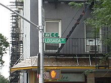
Alphabet City is a neighborhood located within the East Village in the New York City borough of Manhattan. Its name comes from Avenues A, B, C, and D, the only avenues in Manhattan to have single-letter names. It is bounded by Houston Street to the south and 14th Street to the north, and extends roughly from Avenue A to the East River. Some famous landmarks include Tompkins Square Park, the Nuyorican Poets Cafe and the Charlie Parker Residence.
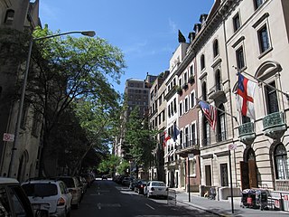
The Upper East Side, sometimes abbreviated UES, is a neighborhood in the borough of Manhattan in New York City, bounded approximately by 96th Street to the north, the East River to the east, 59th Street to the south, and Central Park and Fifth Avenue to the west. The area incorporates several smaller neighborhoods, including Lenox Hill, Carnegie Hill, and Yorkville. Once known as the Silk Stocking District, it has long been the most affluent neighborhood in New York City.

East Harlem, also known as Spanish Harlem or El Barrio, is a neighborhood of Upper Manhattan in New York City, north of the Upper East Side and bounded by 96th Street to the south, Fifth Avenue to the west, and the East and Harlem Rivers to the east and north. Despite its name, it is generally not considered to be a part of Harlem proper, but it is one of the neighborhoods included in Greater Harlem.

Avenue D is the easternmost named avenue in the East Village neighborhood of Manhattan, New York City, east of Avenue C and west of the FDR Drive. It runs through East 13th and Houston Streets, and continues south of Houston Street as Columbia Street until Delancey Street and Abraham E. Kazan Street until its end at Grand Street. Avenues A, B, C and D are the origin of the name of the section of the East Village neighborhood through which they run, Alphabet City.
Second Avenue is located on the East Side of the New York City borough of Manhattan extending from Houston Street at its south end to the Harlem River Drive at 128th Street at its north end. A one-way street, vehicular traffic on Second Avenue runs southbound (downtown) only, except for a one-block segment of the avenue in Harlem. South of Houston Street, the roadway continues as Chrystie Street south to Canal Street.
125th Street, co-named Martin Luther King Jr. Boulevard, is a two-way street that runs east–west in the New York City borough of Manhattan, from First Avenue on the east to Marginal Street, a service road for the Henry Hudson Parkway along the Hudson River in the west. It is often considered to be the "Main Street" of Harlem.
Seventh Avenue—co-named Fashion Avenue in the Garment District and known as Adam Clayton Powell Jr. Boulevard north of Central Park—is a thoroughfare on the West Side of the borough of Manhattan in New York City. It is southbound below the park and a two-way street north of it.
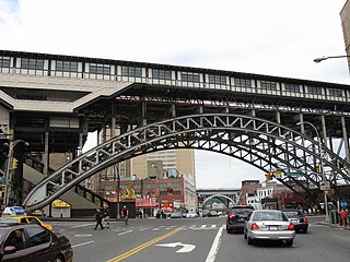
Eighth Avenue is a major north–south avenue on the west side of Manhattan in New York City, carrying northbound traffic below 59th Street. It is one of the original avenues of the Commissioners' Plan of 1811 to run the length of Manhattan, though today the name changes twice: At 59th Street/Columbus Circle, it becomes Central Park West, where it forms the western boundary of Central Park, and north of 110th Street/Frederick Douglass Circle, it is known as Frederick Douglass Boulevard before merging onto Harlem River Drive north of 155th Street.

Avenue A is a north–south avenue located in Manhattan, New York City, east of First Avenue and west of Avenue B. It runs from Houston Street to 14th Street, where it continues into a loop road in Stuyvesant Town, connecting to Avenue B. Below Houston Street, Avenue A continues as Essex Street.

Manhattanville is a neighborhood in the New York City borough of Manhattan bordered on the north by 135th Street; on the south by 122nd and 125th Streets; on the west by Hudson River; and on the east by Adam Clayton Powell Jr. Boulevard and the campus of City College.

96th Street is a major two-way street on the Upper East Side and Upper West Side sections of the New York City borough of Manhattan. It runs in two major sections: between the FDR Drive and Fifth Avenue on the Upper East Side, and between Central Park West and Henry Hudson Parkway on the Upper West Side. The two segments are connected by the 97th Street transverse across Central Park, which links the disconnected segments of 96th and 97th Streets on each side.

The 14th Street Crosstown Line is a public transit line in Manhattan, New York City, running primarily along 14th Street from Chelsea or the West Village to the Lower East Side. Originally a streetcar line, it is now the M14 bus route, operated by the New York City Transit Authority. The line's two variants, the M14A SBS and M14D SBS, use Avenue A and Avenue D respectively from 14th Street south into the Lower East Side.

Lenox Hill is a neighborhood on the Upper East Side of Manhattan in New York City. It forms the lower section of the Upper East Side, east of Park Avenue in the 60s and 70s.
The West Side of Manhattan refers to the side of Manhattan Island that abuts the Hudson River and faces the U.S. state of New Jersey. The West Side is home to several famed New York City locations, including Fifth Avenue, Central Park, and lower Broadway. The major neighborhoods on the West Side are Inwood, Hudson Heights, Washington Heights, West Harlem, Morningside Heights, Manhattan Valley, the Upper West Side, Hell's Kitchen, Chelsea, the West Village, SoHo, and Tribeca. The 8th Avenue and West Side subway lines connect all parts of the West Side.
Mulry Square is a triangular parking lot at the southwest corner of Greenwich Avenue and Seventh Avenue South in Greenwich Village, Manhattan, New York City. It was once thought to be the site of a wedge-shaped diner that was the inspiration for Edward Hopper's famous painting Nighthawks. The parking lot's fencing supports Tiles for America, a September 11 memorial consisting of some 6,000 tiles created across the country.

The Madison Square North Historic District is in Manhattan, New York City, and was created on June 26, 2001, by the city's Landmarks Preservation Commission.

The East 10th Street Historic District is a small historic district located in the Alphabet City area of the East Village neighborhood of Manhattan, New York City. It includes all 26 buildings, numbered 293 to 345, on East 10th Street between Avenue A and Avenue B, across from Tompkins Square Park. The district was designated by the New York City Landmarks Preservation Commission on January 17, 2012.
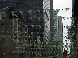
Little Brazil is a small neighborhood in Manhattan, New York City that is centered on the single block of West 46th Street between Fifth and Sixth Avenues. In the 1960s, the street was home to dozens of Brazilian commercial enterprises and Brazilian restaurants, although only a handful remain in the 2000s. It is demarcated by signs between Fifth Avenue and Seventh Avenue, along 46th Street, and several vendors display the green and yellow colors of the Brazilian flag.